Districts of Hungary

Last updated

Districts of Hungary are the second-level divisions of Hungary after counties. They replaced the 175 subregions of Hungary in 2013.

Contents

There are 174 districts in the 19 counties, and there are 23 districts in Budapest. Districts of the 19 counties are numbered by Arabic numerals and named after the district seat, while districts of Budapest are numbered by Roman numerals and named after the historical towns and neighbourhoods. In Hungarian, the districts of the capital and the rest of the country hold different titles. The districts of Budapest are called kerületek (lit. district, pl.) and the districts of the country are called járások.

Districts of Hungary Townships (districts) of Hungary.png
Districts of Hungary

By county

Baranya County

A map of the districts in Baranya County Baranya districts.png
A map of the districts in Baranya County
Baranya County
DistrictDistrict seat Area
(km2)
Population
(2013)
Density
(pop/km2)
No. of
municipalitiestowns
1 Bóly District Bóly 220.0311,87954161
2 Hegyhát District Sásd 360.7212,66635252
3 Komló District Komló 292.4835,084120201
4 Mohács District Mohács 600.9834,90158261
5 Pécs District Pécs 623.07180,138289402
6 Pécsvárad District Pécsvárad 246.4411,78748171
7 Sellye District Sellye 493.6914 38329381
8 Siklós District Siklós 652.9936,10155533
9 Szentlőrinc District Szentlőrinc 282.4315,04453211
10 Szigetvár District Szigetvár 656.7625,15838451

Bács-Kiskun County

A map of the districts in Bacs-Kiskun County Bacs-Kiskun districts.png
A map of the districts in Bács-Kiskun County
Bács-Kiskun County
DistrictDistrict seat Area
(km2)
Population
(2013)
Density
(pop/km2)
No. of
municipalitiestowns
1 Bácsalmás District Bácsalmás 522.5419,98338101
2 Baja District Baja 1,008.8066,60066171
3 Jánoshalma District Jánoshalma 439.0317,2973952
4 Kalocsa District Kalocsa 1,062.2751,02848213
5 Kecskemét District Kecskemét 1,212.21156,413129163
6 Kiskőrös District Kiskőrös 1,130.3355,15549154
7 Kiskunfélegyháza District Kiskunfélegyháza 582.3736,8566361
8 Kiskunhalas District Kiskunhalas 826.3543,7355392
9 Kiskunmajsa District Kiskunmajsa 485.1319,2064061
10 Kunszentmiklós District Kunszentmiklós 769.8129,9063993
11 Tiszakécske District Tiszakécske 405.9923,4355951

Békés County

A map of the districts in Bekes County Bekes districts.png
A map of the districts in Békés County
Békés County
DistrictDistrict seat Area
(km2)
Population
(2013)
Density
(pop/km2)
No. of
municipalitiestowns
1 Békéscsaba District Békéscsaba 636.1682,42413093
2 Békés District Békés 525.2437,2597172
3 Gyomaendrőd District Gyomaendrőd 686.2123,9803552
4 Gyula District Gyula 413.2241,57910142
5 Mezőkovácsháza District Mezőkovácsháza 881.4940,60846184
6 Orosháza District Orosháza 717.1851,3927282
7 Sarkad District Sarkad 570.9723,22841111
8 Szarvas District Szarvas 485.0628,5585961
9 Szeghalom District Szeghalom 714.1930,1254274

Borsod-Abaúj-Zemplén County

A map of the districts in Borsod-Abauj-Zemplen County Borsod-Abauj-Zemplen districts.png
A map of the districts in Borsod-Abaúj-Zemplén County
Borsod-Abaúj-Zemplén County
DistrictDistrict seat Area
(km2)
Population
(2013)
Density
(pop/km2)
No. of
municipalitiestowns
1 Cigánd District Cigánd 389.9916,29442151
2 Edelény District Edelény 717.8634,01247452
3 Encs District Encs 378.3921,78358291
4 Gönc District Gönc 549.6019,54935322
5 Kazincbarcika District Kazincbarcika 341.7265,828193223
6 Mezőcsát District Mezőcsát 351.2714,6354281
7 Mezőkövesd District Mezőkövesd 723.8642,44259232
8 Miskolc District Miskolc 972.80245,384252396
9 Ózd District Ózd 385.5754,527141172
10 Putnok District Putnok 391.2519,25249261
11 Sárospatak District Sárospatak 477.6725,05752161
12 Sátoraljaújhely District Sátoraljaújhely 321.3822,67371212
13 Szerencs District Szerencs 432.0938,25989141
14 Szikszó District Szikszó 309.2417,56637241
15 Tiszaújváros District Tiszaújváros 248.8731,801128161
16 Tokaj District Tokaj 255.8013,38352111

Csongrád-Csanád County

A map of the districts in Csongrad County Csongrad districts.png
A map of the districts in Csongrád County
Csongrád-Csanád County
DistrictDistrict seat Area
(km2)
Population
(2013)
Density
(pop/km2)
No. of
municipalitiestowns
1 Csongrád District Csongrád 339.2422,6976741
2 Hódmezővásárhely District Hódmezővásárhely 707.7756,1647942
3 Kistelek District Kistelek 410.2018,4294561
4 Makó District Makó 688.8544,61265152
5 Mórahalom District Mórahalom 561.7128,74151101
6 Szeged District Szeged 741.10197,679267132
7 Szentes District Szentes 813.8441,2495181

Fejér County

A map of the districts in Fejer County Fejer districts.png
A map of the districts in Fejér County
Fejér County
DistrictDistrict seat Area
(km2)
Population
(2013)
Density
(pop/km2)
No. of
municipalitiestowns
1 Bicske District Bicske 578.2535,66062151
2 Dunaújváros District Dunaújváros 650.0591,854141164
3 Enying District Enying 433.1213,1874691
4 Gárdony District Gárdony 306.7929,77597102
5 Martonvásár District Martonvásár 277.1326,5319682
6 Mór District Mór 417.5534,43183132
7 Sárbogárd District Sárbogárd 653.5228,50944121
8 Székesfehérvár District Székesfehérvár 1,032.05156,935152253

Győr-Moson-Sopron County

A map of the districts in Gyor-Moson-Sopron County Gyor-Moson-Sopron districts.png
A map of the districts in Győr-Moson-Sopron County
Győr-Moson-Sopron County
DistrictDistrict seat Area
(km2)
Population
(2013)
Density
(pop/km2)
No. of
municipalitiestowns
1 Csorna District Csorna 579.7732,88257331
2 Győr District Győr 903.41189,857210351
3 Kapuvár District Kapuvár 372.1423,70564192
4 Mosonmagyaróvár District Mosonmagyaróvár 899.9772,53281262
5 Pannonhalma District Pannonhalma 312.3515,52250171
6 Sopron District Sopron 867.7599,271114393
7 Tét District Tét 272.6214,54353141

Hajdú-Bihar County

A map of the districts in Hajdu-Bihar County Hajdu-Bihar districts.png
A map of the districts in Hajdú-Bihar County
Hajdú-Bihar County
DistrictDistrict seat Area
(km2)
Population
(2013)
Density
(pop/km2)
No. of
municipalitiestowns
1 Balmazújváros District Balmazújváros 827.4430,4883752
2 Berettyóújfalu District Berettyóújfalu 1,073.9045,53942253
3 Debrecen District Debrecen 531.13217,21740922
4 Derecske District Derecske 650.3141,82064132
5 Hajdúböszörmény District Hajdúböszörmény 471.4340,4248622
6 Hajdúhadház District Hajdúhadház 137.0222,32816332
7 Hajdúnánás District Hajdúnánás 547.2729,6385462
8 Hajdúszoboszló District Hajdúszoboszló 732.6543,1755952
9 Nyíradony District Nyíradony 510.3129,8465892
10 Püspökladány District Püspökladány 729.0540,87756122

Heves County

A map of the districts in Heves County Heves districts.png
A map of the districts in Heves County
Heves County
DistrictDistrict seat Area
(km2)
Population
(2013)
Density
(pop/km2)
No. of
municipalitiestowns
1 Bélapátfalva District Bélapátfalva 180.898,8704981
2 Eger District Eger 602.0586,241143222
3 Füzesabony District Füzesabony 578.5630,39653161
4 Gyöngyös District Gyöngyös 750.7873,46098252
5 Hatvan District Hatvan 352.1650,872144132
6 Heves District Heves 697.6835,11650172
7 Pétervására District Pétervására 475.0721,38145201

Jász-Nagykun-Szolnok County

A map of the districts in Jasz-Nagykun-Szolnok County Jasz-Nagykun-Szolnok districts.png
A map of the districts in Jász-Nagykun-Szolnok County
Jász-Nagykun-Szolnok County
DistrictDistrict seat Area
(km2)
Population
(2013)
Density
(pop/km2)
No. of
municipalitiestowns
1 Jászapáti District Jászapáti 544.4533,1606192
2 Jászberény District Jászberény 617.0150,9288393
3 Karcag District Karcag 857.2643,1525053
4 Kunhegyes District Kunhegyes 464.5820,4344472
5 Kunszentmárton District Kunszentmárton 576.4936,30063112
6 Mezőtúr District Mezőtúr 725.7427,7983852
7 Szolnok District Szolnok 914.48118,245129185
8 Tiszafüred District Tiszafüred 417.0519,8954871
9 Törökszentmiklós District Törökszentmiklós 464.5436,7427972

Komárom-Esztergom County

A map of the districts in Komarom-Esztergom County Komarom-Esztergom districts.png
A map of the districts in Komárom-Esztergom County
Komárom-Esztergom County
DistrictDistrict seat Area
(km2)
Population
(2013)
Density
(pop/km2)
No. of
municipalitiestowns
1 Esztergom District Esztergom 537.2692,902173245
2 Kisbér District Kisbér 510.5520 22140171
3 Komárom District Komárom 378.7639,55910493
4 Oroszlány District Oroszlány 199.3925,97313061
5 Tatabánya District Tatabánya 331.6585,054256101
6 Tata District Tata 306.7238,742126101

Nógrád County

A map of the districts in Nograd County Nograd districts.png
A map of the districts in Nógrád County
Nógrád County
DistrictDistrict seat Area
(km2)
Population
(2013)
Density
(pop/km2)
No. of
municipalitiestowns
1 Balassagyarmat District Balassagyarmat 532.9439,82975291
2 Bátonyterenye District Bátonyterenye 215.4521,59010081
3 Pásztó District Pásztó 551.5731,49757261
4 Rétság District Rétság 435.0323,78955251
5 Salgótarján District Salgótarján 525.2364,504123291
6 Szécsény District Szécsény 285.2519,53768141

Pest County

A map of the districts in Pest County Pest districts.png
A map of the districts in Pest County
Pest County
DistrictDistrict seat Area
(km2)
Population
(2013)
Density
(pop/km2)
No. of
municipalitiestowns
1 Aszód District Aszód 298.3736,992126112
2 Budakeszi District Budakeszi 288.9584,646293124
3 Cegléd District Cegléd 886.3089,261101123
4 Dabas District Dabas 614.2348,74679112
5 Dunakeszi District Dunakeszi 103.0778,75776443
6 Érd District Érd 184.29117,30463774
7 Gödöllő District Gödöllő 449.66140,205312156
8 Gyál District Gyál 170.9940,30923642
9 Monor District Monor 329.8164,227195113
10 Nagykáta District Nagykáta 710.1274,168104163
11 Nagykőrös District Nagykőrös 349.2527,8248031
12 Pilisvörösvár District Pilisvörösvár 130.8152,46640192
13 Ráckeve District Ráckeve 417.0536,12087111
14 Szentendre District Szentendre 326.5877,720238134
15 Szigetszentmiklós District Szigetszentmiklós 211.28110,03352196
16 Szob District Szob 438.3224,48756172
17 Vác District Vác 362.2367,781187182
18 Vecsés District Vecsés 119.7447,12639443

Somogy County

A map of the districts in Somogy County Somogy districts.png
A map of the districts in Somogy County
Somogy County
DistrictDistrict seat Area
(km2)
Population
(2013)
Density
(pop/km2)
No. of
municipalitiestowns
1 Barcs District Barcs 696.4723,81734261
2 Csurgó District Csurgó 496.2016,80734181
3 Fonyód District Fonyód 645.4434,59954214
4 Kaposvár District Kaposvár 1,591.36117,49274784
5 Marcali District Marcali 904.2434,73438371
6 Nagyatád District Nagyatád 647.0726,10040181
7 Siófok District Siófok 657.0551,76179243
8 Tab District Tab 427.2412,78630241

Szabolcs-Szatmár-Bereg County

A map of the districts in Szabolcs-Szatmar-Bereg County Szabolcs-Szatmar-Bereg districts.png
A map of the districts in Szabolcs-Szatmár-Bereg County
Szabolcs-Szatmár-Bereg County
DistrictDistrict seat Area
(km2)
Population
(2013)
Density
(pop/km2)
No. of
municipalitiestowns
1 Baktalórántháza District Baktalórántháza 254.4719,52177121
2 Csenger District Csenger 246.5113,83956111
3 Fehérgyarmat District Fehérgyarmat 707.3838,36354501
4 Ibrány District Ibrány 304.9123,8507882
5 Kemecse District Kemecse 246.4122,18590112
6 Kisvárda District Kisvárda 523.0957,050109233
7 Mátészalka District Mátészalka 624.7064,810104263
8 Nagykálló District Nagykálló 377.3730,4308182
9 Nyírbátor District Nyírbátor 695.9443,55763203
10 Nyíregyháza District Nyíregyháza 809.60166,684206154
11 Tiszavasvári District Tiszavasvári 381.6127,3067262
12 Vásárosnamény District Vásárosnamény 617.9436,68959282
13 Záhony District Záhony 145.9219,369133112

Tolna County

A map of the districts in Tolna County Tolna districts.png
A map of the districts in Tolna County
Tolna County
DistrictDistrict seat Area
(km2)
Population
(2013)
Density
(pop/km2)
No. of
municipalitiestowns
1 Bonyhád District Bonyhád 476.8131,58266252
2 Dombóvár District Dombóvár 509.0232,33364161
3 Paks District Paks 836.0049,61059152
4 Szekszárd District Szekszárd 656.1859,41291172
5 Tamási District Tamási 1,019.9338,78538323
6 Tolna District Tolna 205.2418,2108941

Vas County

A map of the districts in Vas County Vas districts.png
A map of the districts in Vas County
Vas County
DistrictDistrict seat Area
(km2)
Population
(2013)
Density
(pop/km2)
No. of
municipalitiestowns
1 Celldömölk District Celldömölk 474.1324,78752282
2 Körmend District Körmend 614.5326,86544462
3 Kőszeg District Kőszeg 286.4525,47389213
4 Sárvár District Sárvár 685.4538,86257422
5 Szentgotthárd District Szentgotthárd 255.0415,18060161
6 Szombathely District Szombathely 646.36110,504171402
7 Vasvár District Vasvár 374.1413,63636231

Veszprém County

A map of the districts in Veszprem County Veszprem districts.png
A map of the districts in Veszprém County
Veszprém County
DistrictDistrict seat Area
(km2)
Population
(2013)
Density
(pop/km2)
No. of
municipalitiestowns
1 Ajka District Ajka 320.7139,154122111
2 Balatonalmádi District Balatonalmádi 239.7624,479102103
3 Balatonfüred District Balatonfüred 357.7424,25068221
4 Devecser District Devecser 421.7314,94835281
5 Pápa District Pápa 1,022.0958,93558491
6 Sümeg District Sümeg 306.4115,39050211
7 Tapolca District Tapolca 540.3034,68964332
8 Várpalota District Várpalota 294.2837,45112782
9 Veszprém District Veszprém 629.6182,353131192
10 Zirc District Zirc 331.0219,51659151

Zala County

A map of the districts in Zala County Zala districts.png
A map of the districts in Zala County
Zala County
DistrictDistrict seat Area
(km2)
Population
(2013)
Density
(pop/km2)
No. of
municipalitiestowns
1 Keszthely District Keszthely 535.9349,38492302
2 Lenti District Lenti 624.1219,78332481
3 Letenye District Letenye 388.6816,41342271
4 Nagykanizsa District Nagykanizsa 907.9178,02286492
5 Zalaegerszeg District Zalaegerszeg 1,044.70102,55398843
6 Zalaszentgrót District Zalaszentgrót 282.5615,51855201

Statistics

By area

By population

By pop. density

By municipalities

See also

Related Research Articles

A county is a geographic region of a country used for administrative or other purposes in some nations. The term is derived from the Old French comté denoting a jurisdiction under the sovereignty of a count (earl) or a viscount. Literal equivalents in other languages, derived from the equivalent of "count", are now seldom used officially, including comté, contea, contado, comtat, condado, Grafschaft, graafschap, and zhupa in Slavic languages; terms equivalent to 'commune' or 'community' are now often instead used.

An independent city or independent town is a city or town that does not form part of another general-purpose local government entity.

<span class="mw-page-title-main">Local government</span> Lowest tier of administration within a sovereign state

Local government is a generic term for the lowest tiers of governance or public administration within a particular sovereign state.

<span class="mw-page-title-main">Bačka</span> Geographical area in the Pannonian Plain

Bačka or Bácska is a geographical and historical area within the Pannonian Plain bordered by the river Danube to the west and south, and by the river Tisza to the east. It is divided between Serbia and Hungary. Most of the area is located within the Vojvodina region in Serbia and Novi Sad, the capital of Vojvodina, lies on the border between Bačka and Syrmia. The smaller northern part of the geographical area is located within Bács-Kiskun County in Hungary.

<span class="mw-page-title-main">Prelog, Croatia</span> Town in Međimurje, Croatia

Prelog is a town in Međimurje County, in northern Croatia. The total population of the town is 4,042, with 7,027 in the town's administrative area, making it the second most populated settlement in the county, after Čakovec.

<span class="mw-page-title-main">Counties of Hungary</span> First-level administrative divisions of Hungary

Hungary is subdivided administratively into 19 counties and the capital city (főváros) Budapest. The counties are further subdivided into 174 districts. The capital Budapest is subdivided into 23 districts.

<span class="mw-page-title-main">Counties of Hungary (1000–1920)</span> Historic administration unit in Hungary

A county is the name of a type of administrative unit in Hungary.

<span class="mw-page-title-main">Gheorgheni</span> Municipality in Harghita, Romania

Gheorgheni is a municipality in Harghita County, Romania, with a population of 15,844, as of 2021. It lies in the Székely Land, an ethno-cultural region in eastern Transylvania. The city administers four villages: Covacipeter (Kovácspéter), Lacu Roșu (Gyilkostó), Vargatac (Vargatag), and Visafolio (Visszafolyó).

<span class="mw-page-title-main">Mohács</span> Town in Baranya, Hungary

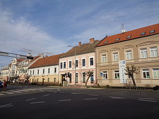
Mohács is a town in Baranya County, Hungary, on the right bank of the Danube.

The NUTS codes of Hungary have three levels:

<span class="mw-page-title-main">Administrative divisions of Yemen</span> One of two main types of bureaucratic divisions in Yemen

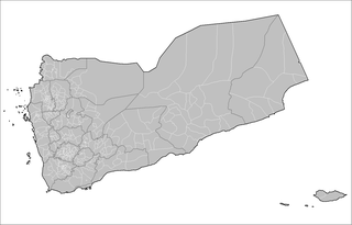
The administrative division of Yemen consists of two main divisions. There are 22 governorates, including the capital Sana'a and Socotra Archipelago. The 22 governorates are then divided into 333 districts, subdivided into 2,210 sub-districts, and then into 38,284 villages.

<span class="mw-page-title-main">Subregions of Hungary</span>

Subregions of Hungary were subdivisions of Hungary, dividing the twenty counties of Hungary into 175 administrative subregions. The subregions were abolished and replaced by 198 districts in 2013.

The ispán or count was the leader of a castle district in the Kingdom of Hungary from the early 11th century. Most of them were also heads of the basic administrative units of the kingdom, called counties, and from the 13th century the latter function became dominant. The ispáns were appointed and dismissed by either the monarchs or a high-ranking royal official responsible for the administration of a larger territorial unit within the kingdom. They fulfilled administrative, judicial and military functions in one or more counties.

<span class="mw-page-title-main">Administrative divisions of the Kingdom of Hungary (1941–1945)</span>

This article discusses the administrative divisions of the Kingdom of Hungary between 1941 and 1945. As a result of the First (1938) and Second Vienna Award (1940), territories that had been ceded by the Kingdom of Hungary at the 1920 Treaty of Trianon were partly regained from Czechoslovakia and Romania respectively. This required modification of the administrative divisions.

There are currently several types of administrative divisions of Hungary; these include:

<span class="mw-page-title-main">Kisbudmér</span> Municipality in Southern Transdanubia, Hungary

Kisbudmér is a village and municipality in Baranya county, Hungary.