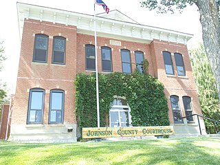
Johnson County is a county in the north central part of the U.S. state of Wyoming. At the 2010 United States Census, the population was 8,569. The county seat is Buffalo. Kaycee is the only other incorporated town in the county.

Big Horn County is a county in the U.S. state of Wyoming. As of the 2010 United States Census, the population was 11,668. The county seat is Basin. Its north boundary abuts the south boundary of Montana.

Worland is a city in Washakie County, Wyoming, United States. The population was 5,487 at the 2010 census. It is the county seat of Washakie County. It is located within the Big Horn Basin and along the Big Horn River in northwestern Wyoming.

The Absaroka Range is a sub-range of the Rocky Mountains in the United States. The range stretches about 150 mi (240 km) across the Montana-Wyoming border, and 75 miles at its widest, forming the eastern boundary of Yellowstone National Park along Paradise Valley, and the western side of the Bighorn Basin. The range borders the Beartooth Mountains to the north and the Wind River Range to the south. The northern edge of the range rests along I-90 and Livingston, Montana. The highest peak in the range is Francs Peak, located in Wyoming at 13,153 ft (4,009 m). There are 46 other peaks over 12,000 ft (3,700 m).
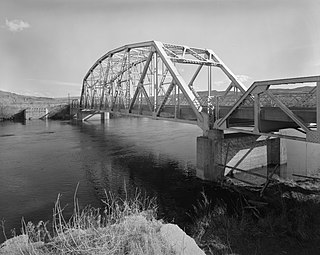
The Bighorn River is a tributary of the Yellowstone, approximately 461 miles (742 km) long, in the states of Wyoming and Montana in the western United States. The river was named in 1805 by fur trader François Larocque for the bighorn sheep he saw along its banks as he explored the Yellowstone.

The Little Bighorn River is a 138-mile-long (222 km) tributary of the Bighorn River in the United States in the states of Montana and Wyoming. The Battle of the Little Bighorn, also known as the Battle of the Greasy Grass, was fought on its banks on June 25–26, 1876, as well as the Battle of Crow Agency in 1887.

The Bighorn Mountains are a mountain range in northern Wyoming and southern Montana in the United States, forming a northwest-trending spur from the Rocky Mountains extending approximately 200 miles (320 km) northward on the Great Plains. They are separated from the Absaroka Range, which lie on the main branch of the Rockies to the west, by the Bighorn Basin. Much of the land is contained within the Bighorn National Forest.

The Bridger Mountains are a short subrange of the Rocky Mountains, approximately 40 miles (64 km) long, in central Wyoming in the United States. The range forms a bridge between the Owl Creek Mountains to the west and the southern end of the Bighorn Mountains to the east. The Wind River passes through the gap between the range and the Owl Creek Mountains. Bridger Creek passes through the gap between the range and the Bighorns. The highest point in the range is Copper Mountain at 8,300 feet (2,500 m).
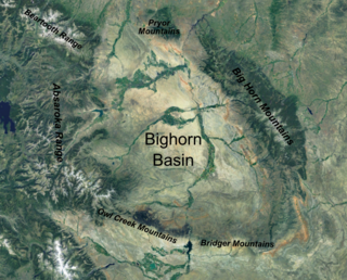
The Bighorn Basin is a plateau region and intermontane basin, approximately 100 miles (160 km) wide, in north-central Wyoming in the United States. It is bounded by the Absaroka Range on the west, the Pryor Mountains on the north, the Bighorn Mountains on the east, and the Owl Creek Mountains and Bridger Mountains on the south. It is drained to the north by tributaries of the Bighorn River, which enters the basin from the south, through a gap between the Owl Creek and Bridger Mountains, as the Wind River, and becomes the Bighorn as it enters the basin. The region is semi-arid, receiving only 6–10 in (15–25 cm) of rain annually.

The Uinta Mountains are an east-west trending chain of mountains in northeastern Utah extending slightly into southern Wyoming in the United States. As a subrange of the Rocky Mountains, they are unusual for being the highest range in the contiguous United States running east to west, and lie approximately 100 miles (160 km) east of Salt Lake City. The range has peaks ranging from 11,000 to 13,528 feet, with the highest point being Kings Peak, also the highest point in Utah. The Mirror Lake Highway crosses the western half of the Uintas on its way to Wyoming.
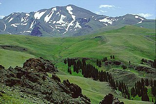
Francs Peak is the highest point in the Absaroka Range which extends from north central Wyoming into south central Montana, in the United States. It is in the Washakie Wilderness of Shoshone National Forest, and the peak is also the highest point in Park County, Wyoming, which includes much of Yellowstone National Park. It was named after Otto Franc, a cattle baron and homesteader in the Big Horn Basin.
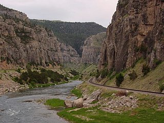
Wind River Canyon is a scenic Wyoming canyon on the Wind River. It is located between the towns of Shoshoni and Thermopolis and is a popular stop for visitors to Yellowstone National Park. It is accessible by U.S. Highway 20 and Wyoming Highway 789. It was designated as a Wyoming Scenic Byway in 2005.

The Bridger Trail, also known as the Bridger Road and Bridger Immigrant Road, was an overland route connecting the Oregon Trail to the gold fields of Montana. Gold was discovered in Virginia City, Montana in 1863, prompting settlers and prospectors to find a trail to travel from central Wyoming to Montana. In 1863, John Bozeman and John Jacobs scouted the Bozeman Trail, which was a direct route to the Montana gold fields through the Powder River Country. At the time the region was controlled by the Sioux, Cheyenne and Arapaho, who stepped up their raids in response to the stream of settlers along the trail.
In the U.S. state of Wyoming, U.S. Highway 14 runs east to west across the northern part of the state. The road connects South Dakota on the east with Yellowstone National Park on the west. It is mostly a two lane surface road except for several sections that it shares with Interstate 90.
The Nowood River is a river in the U.S. state of Wyoming. The 95 miles (153 km)-river rises in the Bridger Mountains on the southeastern side of the Bighorn Basin. The stream runs north through the foothills of the Bighorn Mountains and past the town of Ten Sleep where it is joined by Tensleep Creek. The river then flows out of the Bighorn mountains to join the Big Horn River near Manderson. Local tradition relates that a group of men arrived on the river and found no wood to construct a fire, thus the name "No wood".
Wyoming Highway 433 is a 18.81-mile-long (30.27 km) Wyoming state road in Washakie and Big Horn counties.
Wyoming Highway 434 is a 20.63-mile-long (33.20 km) Wyoming state road in Washakie county.

The Mesaverde Group is a Late Cretaceous stratigraphic group found in areas of Colorado, New Mexico, Utah, and Wyoming, in the Western United States.

Mayoworth is an unincorporated place in the southwestern part of Johnson County in north-central Wyoming, United States. It lies in the eastern valleys of the Bighorn Mountains. Mayoworth is at the western terminus of Wyoming Highway 191, approximately 12 miles west of the Kaycee exit off Interstate 25.
Barnum is an unincorporated place in the southwestern part of Johnson County in north-central Wyoming, United States. It lies in the eastern valleys of the Bighorn Mountains. Barnum is at the western terminus of Wyoming Highway 190, approximately 17 miles west of the Kaycee exit off Interstate 25.

