Related Research Articles

Roanoke is an independent city in the U.S. state of Virginia. At the 2020 census, the population was 100,011, making it the eighth-most populous city in the state and the largest city west of Richmond. It is located in the Roanoke Valley of the Roanoke Region of Virginia.
Stokes County is a county located in the U.S. state of North Carolina. As of the 2020 census, the population was 44,520. Its county seat is Danbury.
Paxson is a census-designated place (CDP) in Copper River Census Area, Alaska, United States. As of the 2020 census, its population was 26, down from 40 in 2010. It is located on the Richardson Highway at the junction with the Denali Highway.

Louisa is an American city located in eastern Kentucky at the merger of the Levisa and Tug Forks into the Big Sandy River, which forms part of the state's border with West Virginia. It is located in Lawrence County the seat of its county. The population was 2,467 at the 2010 census and an estimated 2,375 in 2018.

Bozeman is a city and the county seat of Gallatin County, Montana, United States. Located in southwest Montana, the 2020 census put Bozeman's population at 53,293 making it the fourth-largest city in Montana. It is the principal city of the Bozeman, MT Micropolitan Statistical Area, consisting of all of Gallatin County with a population of 118,960. It is the largest micropolitan statistical area in Montana, the fastest growing micropolitan statistical area in the United States in 2018, 2019 and 2020, as well as the second-largest of all Montana's statistical areas.

Clintwood is a town in Dickenson County, Virginia, United States. The population was 1,414 at the 2010 census, with an estimated population of 1,304 in 2018. It is the county seat of Dickenson County.

Pearisburg is a town in Giles County, Virginia, and the county seat. The population was 2,786 at the time of the 2010 census. Pearisburg is part of the Blacksburg–Christiansburg Metropolitan Statistical Area.

Abingdon is a town in Washington County, Virginia, United States, 133 miles (214 km) southwest of Roanoke. The population was 8,376 at the 2020 census. It is the county seat of Washington County. The town encompasses several historically significant sites and features a fine arts and crafts scene centered on the galleries and museums along Main Street.
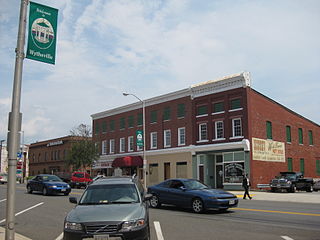
Wytheville is a town in, and the county seat of, Wythe County, Virginia, United States. It is named after George Wythe, a signer of the United States Declaration of Independence, and mentor to Thomas Jefferson. Wytheville's population was 8,211 at the 2010 census. Interstate Highways 77 and 81 were constructed to intersect at the town, long a crossroads for travelers.

Whitesville is a town and former coal town in Boone County, West Virginia, United States, along the Big Coal River. The population was 361 at the 2020 census. Whitesville was incorporated on August 15, 1935 by the Boone County Circuit Court. The town derives its name from B. W. White, a pioneer settler. Whitesville was formerly known as Jarrold's Valley and Pritchard City.

Ripley is a city in and the county seat of Jackson County, West Virginia, United States. The population was 3,074 at the 2020 census.

The James River is a river in Virginia that begins in the Appalachian Mountains and flows 348 miles (560 km) to the Chesapeake Bay. The river length extends to 444 miles (715 km) if the Jackson River is included, the longer of its two headwaters. It is the longest river in Virginia. Jamestown and Williamsburg, Virginia's first colonial capitals, and Richmond, Virginia's current capital, lie on the James River.

The Cumberland River is a major waterway of the Southern United States. The 688-mile-long (1,107 km) river drains almost 18,000 square miles (47,000 km2) of southern Kentucky and north-central Tennessee. The river flows generally west from a source in the Appalachian Mountains to its confluence with the Ohio River near Paducah, Kentucky, and the mouth of the Tennessee River. Major tributaries include the Obey, Caney Fork, Stones, and Red Rivers.

The Eastern Continental Divide, Eastern Divide or Appalachian Divide is a hydrographic divide in eastern North America that separates the easterly Atlantic Seaboard watershed from the westerly Gulf of Mexico watershed. The divide nearly spans the United States from south of Lake Ontario through the Florida peninsula, and consists of raised terrain including the Appalachian Mountains to the north, the southern Piedmont Plateau and lowland ridges in the Atlantic Coastal Plain to the south. Water including rainfall and snowfall, lakes, streams and rivers on the eastern/southern side of the divide drains to the Atlantic Ocean; water on the western/northern side of the divide drains to the Gulf of Mexico. The ECD is one of six continental hydrographic divides of North America which define several drainage basins, each of which drains to a particular body of water.

Tazewell County is a county located in the southwestern portion of the U.S. state of Virginia. As of the 2020 census, the population was 40,429. Its county seat is Tazewell.
The Cumberland Gap is a pass in the eastern United States through the long ridge of the Cumberland Mountains, within the Appalachian Mountains and near the tripoint of Kentucky, Virginia, and Tennessee. At an elevation of 1,631 feet (497 m) above sea level, it is famous in American colonial history for its role as a key passageway through the lower central Appalachians.

The Rapidan River, flowing 88 miles (142 km) through north-central Virginia in the United States, is the largest tributary of the Rappahannock River. The two rivers converge just west of the city of Fredericksburg. The Rapidan River begins west of Doubletop Mountain in Shenandoah National Park where the Mill Prong meets the Laurel Prong at Rapidan Camp, approximately 3 miles (4.8 km) south of Big Meadows. The river defines the border of Orange County with Culpeper and Madison Counties.

Steins is a ghost town in Stein's Pass of Hidalgo County, New Mexico. It was originally called Stein's Pass after the nearby pass through the Peloncillo Mountains. The pass was named after United States Army Major Enoch Steen, who camped nearby in 1856, as he explored the recently acquired Gadsden Purchase.

Stein's Pass, is a gap or mountain pass through the Peloncillo Mountains of Hidalgo County, New Mexico. The pass was named after United States Army Major Enoch Steen, who camped nearby in 1856, as he explored the recently acquired Gadsden Purchase. The pass is in the form of a canyon cut through the mountains through which Steins Creek flows to the west just west of the apex of the pass to the canyon mouth at 32°13′19″N109°01′48″W.
References
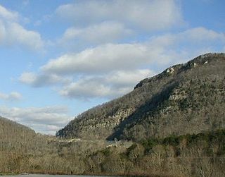
- ↑ "Walker Mountain". Geographic Names Information System . United States Geological Survey, United States Department of the Interior . Retrieved June 28, 2023.
- ↑ Proceedings, American Philosophical Society (vol. 24, 1887). American Philosophical Society. ISBN 9781422373668 . Retrieved 19 April 2023.
- ↑ Bolbert, Judy (26 August 2019). Virginia Off the Beaten Path®. Globe Pequot. ISBN 9781493042661 . Retrieved 19 April 2023.
- ↑ Oliver, Lance (April 2003). "Peak Experience". American Motorcyclist. Retrieved 19 April 2023.