This article needs additional citations for verification .(October 2018) |
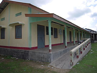
Bilasipara is a town, sub-division and town area committee in Dhubri district in the state of Assam, India.
This article needs additional citations for verification .(October 2018) |
Bilasipara is a town, sub-division and town area committee in Dhubri district in the state of Assam, India.
This town is under Bilasipara Municipal Board (BMB) and is part of two MLA constituency namely 27 Bilasipara East 26 Bilasipara West. It has a population of approximately fifty thousand (excluding the Bilasipara sub-division). The widely spoken language of the town is 'Ujani'; the locals call it 'Desi'. People of many religions, castes and mother-tongues are found here.
The official population of the town in 2015 is more than 50,000. The MLA of 27 Bilasipara East constituency is Samsul Huda (AIUDF) and the MLA of 26 Bilasipara West is Hafiz Bashir Ahmed (AIUDF)
Bilasipara is located at 26°14′N90°14′E / 26.23°N 90.23°E . [1] It has an average elevation of 26 metres (85 feet).
The outer parts of the town suffer from flooding almost yearly; it poses a major problem.
A large number of people residing near the town in the sub-divisional areas are involved in farming and food production. Products available in the market are mostly from the nearby villages and the surrounding area. Paddy fields line either side of the highway. The fields produce mustard seeds in their season. Food and paddy products are exported to other towns, cities and states. A river known as Gaurang, which is a tributary of the Brahmaputra, enters the town from the east. It is the only water source other than small lakes and ponds.

This town is well known for its educational institutions. There are many English medium and Assamese medium schools in the town, and Hindi and Bengali medium schools and colleges.
Bilasipara
The town has one civil hospital, one SHC hospital and a few private clinics.
Traditionally, Goalparia music is the main form of traditional music here.
The town is well connected by Bus routes especially with north Bengal, North of Assam and Upper Assam as well, on 25 March 2019 Bilasipara connected with Rail routes too. , 3-wheeler and 4 wheeler passenger carriers, rickshaws and tuk-tuks are available.

Nagaon is the second largest city of Assam, India and the largest district of Assam. Nagaon is the headquarters of central Assam division. It is situated 120 km east of state's capital Dispur, Guwahati and 55 km west of Kaziranga National Park.

Jorhat is an administrative district of the Indian state of Assam situated in the central part of the Brahmaputra Valley. The district is bounded by Majuli on north, Nagaland state on the south, Sivasagar on the east and Golaghat on the west. On the north of the district, the river Brahmaputra forms the largest riverine island of the world. The administrative seat is at Jorhat city.
Barpathar is a town and a municipality board in Golaghat district in the state of Assam, India. Popular Industrialist Shri Balabux Sutodiya, Shri Om Prakash Sutodiya
Dergaon is a town and a municipality in the Golaghat district of Assam, India. It is 282 km from the state capital Guwahati.
Hojai is a town and a municipal board in Hojai district in the Indian state of Assam. It is located on the banks of the two tributaries of Brahmaputra, namely Kapili and Jamuna.
Jagiroad is a town in the state of Assam. Jagiroad located in Mayong Sub-Division, in Morigaon district. It is situated on the south bank of Kolong river.
Mankachar is a census town in South Salmara-Mankachar District in the Indian state of Assam. It is situated at the extreme south-westernmost end of North-East India.
Mariani is a neighbourhood town of Jorhat. It is about 17.5 km from Jorhat Town railway station. Mariani is in the border of Nagaland. Mariani is famous for the Gibbon Wildlife Sanctuary which is located on the roadside on the way to Nakachari from Mariani at a distance of 5 km. Pincode of Mariani is 785634.
Nazira is a town and a municipal board in Sivasagar district in the Indian state of Assam.

North Lakhimpur is a city and a municipal board in Lakhimpur district in the Indian state of Assam, about 394 kilometres (245 mi) northeast of Guwahati. It is the district headquarters of Lakhimpur district.
Sarupathar is a town and the Sub-Divisional headquarter of Dhansiri Sub-Division in Golaghat district in the state of Assam, India.
Sonari is a district Headquarter, mid-size town and a municipal board in newly announced Charaideo district in the Indian state of Assam.

Chokapara is a village under Lakhiganj Gaon Panchayat, some 7 kilometers distance north from the Bilasipara town in the Dhubri district of Assam, one of the seven sister states of North-East India. It is one of the very old revenue villages of the erstwhile Goalpara district. According to 2001 India census, Chokapara had a population of 1,148 in 253 households. Males constitute ~52 % of the population and females ~48 %.
Lakhiganj is a village, a small Bazaar (market), a post office and a Gaon Panchayat in the Dhubri district of Assam, around 8 km north from Bilasipara,. It is situated on the Bilasipara-Kokrajhar state highway, around 12 km from Kokrajhar town and 9 km from Fakiragram railway station. The bazaar hosts weekly market on Monday and Friday. It has a small township comprising people of different backgrounds and as such they represent a mixed culture. The people of this Bazzar area basically speak Goalpariya, Assamese, although Marawari, Bihari and Bengalis’ are also there. The people are primarily dependent on small-scale business. However, it is surprising that this the place where Motram Surajmal Dugar first established a small firm in 1906 and now it is a big business house, named "the MS Dugar group of companies" operate all over India.
Kaliabor, a sub-division town in Nagaon district of Assam situated at a distance of 48 km east of Nagaon town. It was the headquarters of Borphukans during the Ahom era. Kaliabor lies in the middle of assam and surrounded in the north by the Brahmaputra, in the south by the hills of Karbi Anglong district, in the east by Kaziranga National Park under Golaghat district and in the west by Samaguri under Nagaon Sadar Sub-Division.
Ghilamara is a small town situated in the far east of Lakhimpur district in Assam.
Agomani is a sub town area of Dhubri district (Assam) India. It is an area on the bank of Gangadhar River with historical significance. Agomani stands in a rural area, but it is not a revenue village. Some portions of the village of Kaldoba and Shernagar and total number of 41 villages in block formed the big area of Agomani. The area of Agomani is about 214 km2 Agomani is situated at a distance of 50 km to the North West of Dhubri, 12 km to the South of West Bengal border and 8 km to the North East of Bangladesh border. National Highway 17 passes through Agomani from North to South and the historical Gohain Kamal Ali (Road) runs from East to West. Both the roads crossed it the heart of Agomani. At the conjunction, there is a daily market and shops of all kinds are established. In 1963 a terrible Cyclone blew over Agomani and swept away many houses, lives and properties and the name of Agomani appeared on Newspaper, Radio & T.V and Agomani had been known to all over Assam.

Bhuragaon is the name of a town in the Indian state of Assam. Bhuragaon is located in Morigaon district. The town is situated on the south bank of the river Brahmaputra.
Charbari (Gazarikandi) is a village under Kathalbari and Kukurmara Gaon panchayat in Mankachar revenue circle, South Salmara-Mankachar district of Assam a north east state of India.
Jamunamukh is a town located in the district of Hojai in the Indian state of Assam. It is situated on the bank of the Jamuna River, which flows through the town and gives it its name. Jamunamukh is surrounded by three rivers - Jamuna, Kapili, and Nikhari.