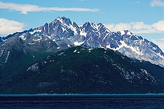
Mount Abdallah is a prominent 6,210-foot (1,893-meter) mountain summit located in the Alsek Ranges of the Saint Elias Mountains, in southeast Alaska. The mountain is situated in Glacier Bay National Park and Preserve, as the highest point between Tarr Inlet and Rendu Inlet, 93 mi (150 km) northwest of Juneau, and 10.5 mi (17 km) southeast of Mount Barnard, which is the nearest higher peak. Although modest in elevation, relief is significant since the mountain rises up from tidewater in less than three miles. The mountain was named in 1892 by Harry Fielding Reid, an American geophysicist, who in 1892 hired a small crew of men for an expedition to study glaciology in Glacier Bay. There is no record of who Reid named this mountain for, but a member of his expeditionary crew who accompanied him might be a possibility. The months May through June offer the most favorable weather for viewing Mount Abdallah. Weather permitting, Mount Abdallah can be seen from Glacier Bay, which is a popular destination for cruise ships.
Blackthorn Peak, also known as Black Thorn, is a 4,117 foot mountain summit located at the head of Glacier Bay's Geikie Inlet in Glacier Bay National Park and Preserve, in the Fairweather Range of the Saint Elias Mountains, in southeast Alaska. The mountain is situated immediately east of Geikie Glacier, 80 mi (129 km) west-northwest of Juneau, and 2.5 mi (4 km) north of Threesome Mountain, which is the nearest higher peak. Although modest in elevation, relief is significant since the mountain rises up from tidewater in a little over two miles. The mountain was given its descriptive name in 1896 by Harry Fielding Reid, an American geophysicist who studied glaciology in Glacier Bay. Weather permitting, Blackthorn Peak can be seen from Glacier Bay, which is a popular destination for cruise ships. The months May through June offer the most favorable weather for viewing or climbing the peak.

Mount Merriam is a prominent 5,083-foot (1,549-meter) mountain summit located in Glacier Bay National Park and Preserve, in the Alsek Ranges of the Saint Elias Mountains, in southeast Alaska. The mountain is situated 75 mi (121 km) northwest of Juneau, 3.1 mi (5 km) south of Mount Wordie, 3.5 mi (6 km) north of Black Cap Mountain, and 13.4 mi (22 km) southeast of Mount Abdallah which is the nearest higher peak. Although modest in elevation, relief is significant as the mountain rises up from tidewater in less than three miles, and it ranks 85th in prominence for all peaks in Alaska.

Black Cap Mountain is a 3,321-foot (1,012-meter) mountain summit located in Glacier Bay National Park and Preserve, in the Alsek Ranges of the Saint Elias Mountains, in southeast Alaska. The mountain is situated immediately north of the entrance to Tidal Inlet, 80 mi (129 km) northwest of Juneau, and 3.5 mi (6 km) south of Mount Merriam, which is the nearest higher peak. Although modest in elevation, relief is significant as the mountain rises up from tidewater in less than two miles. The mountain's descriptive name was given by the U.S. Geological Survey in 1956 because the summit is composed of black limestone which contrasts with the color of the flanks of the mountain, making it visible for many miles. The mountain's name was officially adopted in 1960 by the U.S. Board on Geographic Names. Weather permitting, Black Cap Mountain can be seen from Glacier Bay, which is a popular destination for cruise ships. The months May through June offer the most favorable weather for viewing or climbing the peak.

Mount Wordie is a 4,700+ foot mountain summit located in Glacier Bay National Park and Preserve, in the Alsek Ranges of the Saint Elias Mountains, in southeast Alaska. The mountain is situated 80 mi (129 km) northwest of Juneau, 4 mi (6 km) south of Carroll Glacier, and 3.1 mi (5 km) north of Mount Merriam which is the nearest higher peak. Although modest in elevation, relief is significant as the mountain rises up from tidewater in less than two miles.

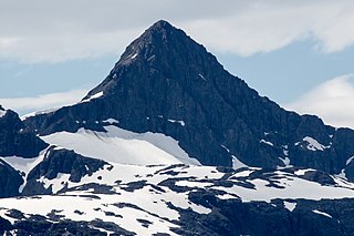
Mount Case is a prominent 5,545-foot (1,690 m) mountain summit located in the Alsek Ranges of the Saint Elias Mountains, in southeast Alaska. The mountain is situated in Glacier Bay National Park and Preserve, as the highest point between Adams Inlet and White Glacier, 65 mi (105 km) northwest of Juneau, and 2.47 mi (4 km) northeast of Mount Wright, which is the nearest peak. Although modest in elevation, relief is significant as the mountain rises up from tidewater in less than three miles, and it ranks 73rd in prominence for all peaks in Alaska. The mountain was named in 1890 by Harry Fielding Reid, an American geophysicist, who studied glaciology in Glacier Bay. Reid named this mountain for his school, the Case School of Applied Science, in Cleveland, Ohio. The months May through June offer the most favorable weather for viewing or climbing Mount Case. Weather permitting, Mount Case can be seen from Glacier Bay, which is a popular destination for cruise ships.

Marble Mountain is a 3,366-foot (1,026-meter) mountain summit located in the Fairweather Range of the Saint Elias Mountains, in southeast Alaska. The peak is situated in Glacier Bay National Park and Preserve at the entrance to Geikie Inlet, 68 mi (109 km) west-northwest of Juneau, and 10.7 mi (17 km) east-northeast of Blackthorn Peak. Although modest in elevation, relief is significant since the mountain rises up from tidewater in Shag Cove in less than one mile. The mountain's name was in local use as reported by the United States Geological Survey in 1951. Marble Mountain can be seen from Glacier Bay which is a popular destination for cruise ships. The months May through June offer the most favorable weather for viewing and climbing Marble Mountain.

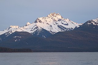
Black Mountain is a prominent 5,891 foot mountain summit located in the Alsek Ranges of the Saint Elias Mountains, in southeast Alaska. The mountain is situated in Glacier Bay National Park and Preserve, 75 mi (121 km) northwest of Juneau, between the Riggs and McBride glaciers. The months May through June offer the most favorable weather for viewing or climbing Black Mountain. Weather permitting, Black Mountain can be seen from Muir Inlet of Glacier Bay, which is a popular destination for cruise ships.

Double Peak is a prominent 6,818 foot mountain summit located in Lake Clark National Park and Preserve, in the Chigmit Mountains of the Aleutian Range, in the US state of Alaska. It is the highest non-volcanic peak in the Chigmit Mountains, and third-highest overall. The mountain is situated immediately north of Double Glacier, 100 mi (161 km) west-southwest of Anchorage, and 17.74 mi (29 km) north-northeast of Redoubt Volcano, which is the nearest higher peak. Although modest in elevation, relief is significant since the mountain rises up from tidewater at Cook Inlet in about 20 miles, and it ranks 71st in prominence for all peaks in Alaska.. Published in 1912 by the United States Coast and Geodetic Survey, the mountain takes its name from the Double Glacier which the peak overlooks. The first ascent of the mountain was made May 19, 1973, by Steve Hackett, John Samuelson, Helmut Tschaffert, Toby Wheeler, Daniel Hurd, and Daniel Jones via the steep northwest snow face. The months May through June offer the most favorable weather for viewing or climbing the peak.

Mount Tom White is a prominent 11,191-foot glaciated mountain summit located in the Chugach Mountains, in the U.S. state of Alaska. The remote peak is situated on land managed by Chugach National Forest, 72 mi (116 km) northeast of Cordova, and 20 mi (32 km) north of the Bering Glacier, North America's largest glacier. The mountain lies within the Copper River drainage basin, and is the eighth-highest major peak in the Chugach Mountains. Topographic relief is significant as it ranks 17th in prominence for all peaks in Alaska, and 52nd for all North America peaks.. The first ascent of the mountain was made in 1973 by Story Clark, Chris Hall, Tom Kizzia, William Resor, Sarah Robey, and Don White.

Dillon Mountain is a prominent 4,820-foot mountain summit located in the Philip Smith Mountains of the Brooks Range, in the U.S. state of Alaska. The peak is situated 93 miles north of the Arctic Circle near milepost 207 on the Dalton Highway, and 200 mi (322 km) north-northwest of Fairbanks, where the Bettles and Dietrich Rivers merge to form West Fork Koyukuk River. Sukakpak Mountain rises 3 mi (5 km) to the southwest, and Dietrich Camp of the Trans-Alaska Pipeline lies 3 mi (5 km) to the northwest. The peak was named after John Thomas Dillon (1947-1987), a geologist with the Alaska Division of Geological and Geophysical Surveys who mapped the geology of the southern Brooks Range mineral belt. He died tragically with his father, Stephen Patrick Dillon, in an airplane crash in the Brooks Range while returning home from field work in July 1987. The name was officially adopted in 1990 by the U.S. Board on Geographic Names. This landmark is notable for its massive west face composed of Skajit limestone rising nearly 3,400 feet above the surrounding valley.

Passage Peak is a prominent 5,990-foot (1,826 m) mountain summit located in the Chugach Mountains, in the U.S. state of Alaska. The unofficially named peak is situated in Chugach National Forest, 9 mi (14 km) northeast of Whittier, Alaska, near the isthmus of the Kenai Peninsula, where the Chugach Mountains meet the Kenai Mountains. Nearby peaks include Maynard Mountain and Boggs Peak, each approximately 10 mi (16 km) to the southwest. Although modest in elevation, relief is significant since the southern aspect of the mountain rises up from the tidewater of Prince William Sound's Passage Canal in approximately five miles. The peak takes its name from Passage Canal, which in turn was named in 1794 by Captain George Vancouver, presumably because it leads to a portage connecting Prince William Sound with Cook Inlet.

Sinclair Mountain is a prominent 6,800+ ft mountain summit located in the Boundary Ranges of the Coast Mountains, in the U.S. state of Alaska. The peak is situated 26 mi (42 km) south of Skagway, and 15 mi (24 km) north of Lions Head Mountain, on land managed by Tongass National Forest. Although modest in elevation, relief is significant since Sinclair Mountain rises 6,800 feet above the entrance to Chilkoot Inlet in 3.5 mi (6 km). The peak's name was established in 1920 by the U.S. Coast and Geodetic Survey to remember Cephas Hempstone Sinclair (1847–1920), hydrographic and geodetic engineer who had 47 years of field service with that agency. The mountain's name was officially adopted in 1920 by the U.S. Board on Geographic Names. The first ascent of this seldom climbed peak was made in mid-June 1973 by Jerry Buckley, Joe Greenough, and Craig Lingle.
Mount Harding is a prominent 5,321 ft (1,620 m) mountain summit located in the Boundary Ranges of the Coast Mountains, in the U.S. state of Alaska. The peak is situated 4.5 mi (7 km) southwest of Skagway, and 3 mi (5 km) south of Face Mountain, on land managed by Tongass National Forest. Although modest in elevation, relief is significant since Mount Harding rises 5,300 feet above Taiya Inlet in less than 2 mi (3 km). The peak was named in 1924 by the Skagway Alpine Club to honor President Warren G. Harding (1865–1923), 29th president of the United States who visited Skagway on July 11, 1923. He was the first and only president to visit Skagway. Harding died three weeks later in San Francisco. The mountain's name was officially adopted in 1986 by the U.S. Board on Geographic Names. Precipitation runoff from the mountain drains east into Taiya Inlet, and west into Ferebee River.

Face Mountain is a 5,052 ft (1,540 m) mountain summit located in the Boundary Ranges of the Coast Mountains, in the U.S. state of Alaska. The peak is situated 4.2 mi (7 km) west-northwest of Skagway, and 4.3 mi (7 km) north of Mount Harding, on land managed by Tongass National Forest. Although modest in elevation, relief is significant since Face Mountain rises above tidewater of Taiya Inlet in less than 2.5 miles. This geographic feature was named "Parsons Peak" in 1897 by the U.S. Coast and Geodetic Survey, and has had variant names "Gnome Mountain", and "The Sphinx" used locally to describe a face in the rock. The mountain's present name and summit location was officially adopted in 1985 by the U.S. Board on Geographic Names, however USGS maps still show the old name, Parsons Peak, as the summit. Precipitation runoff from the mountain drains into tributaries of Taiya Inlet.
Eagle Peak is a prominent 4,650-foot (1,417 m) elevation mountain summit located on Admiralty Island in the Alexander Archipelago, in the U.S. state of Alaska. It is the second-highest peak on the island, and is situated 14 mi (23 km) southwest of Juneau, within Admiralty Island National Monument, on land managed by Tongass National Forest. Although modest in elevation, relief is significant since the peak rises up from tidewater at Stephens Passage in 4.5 mi (7 km). This geographic feature's local name was published by the U.S. Geological Survey in 1951.

Mount Nagishlamina is an 11,068-foot glaciated mountain summit located in the Tordrillo Mountains of the Alaska Range, in the US state of Alaska. The mountain is situated 90 mi (145 km) west of Anchorage, 7.4 mi (12 km) northwest of Mount Spurr, and 1.9 mi (3 km) southeast of Mount Torbert, which is the nearest higher neighbor. It is the fifth-highest peak in the Tordrillo Mountains, a subset of the Alaska Range. The mountain takes its Denaʼina language name from the Nagishlamina River which drains the west side of the peak. Mount Nagishlamina's name was in use by local mountaineers since the 1970s, and was officially adopted in 1999 by the U.S. Board on Geographic Names. This geographic feature was likely the highest unclimbed peak in the United States at the time of its first ascent in 1989 by Dave Johnston.

Mount Carmack is a prominent 6,808 ft (2,080 m) elevation mountain summit located in the Boundary Ranges of the Coast Mountains, in the U.S. state of Alaska. The peak is situated 7 mi (11 km) north-northeast of Skagway, and 3.5 mi (6 km) south of Mount Cleveland, on land managed by Tongass National Forest. As the highpoint on the divide between the Taiya River and the Skagway River, precipitation runoff from the mountain drains east into the Skagway River and west into Taiya River, both of which empty into Taiya Inlet. Although modest in elevation, relief is significant since Mount Carmack rises 6,800 feet above the Taiya valley in less than 2 mi (3 km), and 5,800 feet above Skagway valley in about 2 miles. Mount Carmack has a lower subsidiary summit, elevation 6,621 ft (2,020 m), about 0.5 mi (1 km) to the northeast of the true summit. The USGS map has this lower northeast peak labelled as Mount Carmack.

McHugh Peak is a 4,308-foot (1,313 m) mountain summit located in the western Chugach Mountains, in Anchorage Municipality, in the U.S. state of Alaska. McHugh Peak is situated in Chugach State Park, 14 mi (23 km) southeast of downtown Anchorage, and 5 mi (8 km) southwest of O'Malley Peak. Reaching the top involves hiking on a ridge trail and scrambling the final summit tor. The hike to McHugh Peak is detailed in several popular guidebooks. This geographic feature's local name was reported in 1942 by the Army Map Service, and was officially adopted in 1969 by the U.S. Board on Geographic Names.. The mountain's name is derived from McHugh Creek which drains the south slope of this peak, and the creek's name was first published in 1912 by the U.S. Coast and Geodetic Survey. This mountain is called Q'isqa Dghelaya in the Denaʼina language, meaning Banjo Snowshoe Mountain. "Q'isqa" are temporary snowshoes made of lashed brush.
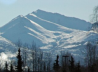
Wolverine Peak is a 4,491-foot (1,369 m) mountain summit located in the western Chugach Mountains, in Anchorage Municipality, in the U.S. state of Alaska. Wolverine Peak is situated in Chugach State Park, 10 mi (16 km) southeast of downtown Anchorage, and 2.6 mi (4 km) northwest of O'Malley Peak. It is a prominent mountain on the Anchorage skyline. This geographic feature was so-named in 1963 by members of the Mountaineering Club of Alaska who found wolverine tracks in the snow near the summit. The name was officially adopted in 1964 by the U.S. Board on Geographic Names. A popular hike on a five-mile trail leads to the summit with views of Mount Williwaw, Denali, Mount Foraker, Cook Inlet, and Anchorage.

