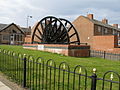
Seaham is a seaside town in County Durham, England. Located on the Durham Coast, Seaham is situated 6 miles south of Sunderland and 13 miles (21 km) east of Durham. The town grew from the late 19th century onwards as a result of investments in its harbour and coal mines. The town is twinned with the German town of Gerlingen.

Peterlee is a town in County Durham, England. It lies between Sunderland to the north, Hartlepool to the south, the Durham Coast to the east and Durham to the west. It gained town status in 1948 under the New Towns Act 1946. The act also created the nearby settlement of Newton Aycliffe and later Washington, Tyne and Wear.
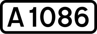
The A1086 is a road in County Durham, north-east England.

Hesleden is a village in County Durham, England, south of Peterlee. The name is a combination of Dene and Hesle, which is from "hazel". The combined population of the five communities making up the parish of Monk Hesleden was 5,722 at the 2011 Census.
Blackhall Rocks is a village on the North Sea coast of County Durham, North East England. It is situated on the A1086 between Horden and Hartlepool, and just south of Blackhall Colliery which it adjoins. It is sometimes referred to by locals in the area as "The Rocks".

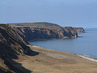
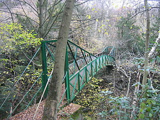
Horden is a village and electoral ward in County Durham, England. It is situated on the North Sea coast, to the east of Peterlee, approximately 12 miles south of Sunderland. Horden was a mining village until the closure of the Horden Colliery in 1987. Main features include the Welfare and Memorial Parks and St Mary's church. It is connected to the villages of Blackhall Colliery and Blackhall Rocks to its south by a spectacular rail viaduct which spans Castle Eden Dene near Denemouth. Horden Dene provides Horden's northern boundary with Easington Colliery.
Monk Hesleden is a village and civil parish in County Durham, England. The population of the parish at the 2011 Census was 5,722. The parish is situated to the north-west of Hartlepool, and is on the North Sea coast. Monk Hesleden village is situated a short distance to the south of High Hesleden.

Thornley is a village in County Durham, in England. It is situated about 5 miles (9 km) to the east of Durham and 5 miles (7 km) west of Peterlee. Thornley is part of the Sedgefield parliamentary constituency of which Tony Blair was the Member of Parliament from 1983 until 2007.

Hutton Henry is a village in County Durham, in England near Peterlee, Castle Eden and Wingate. The population of the parish at the 2011 census was 1,565. It is situated to the west of Hartlepool, near the villages of Wingate and Station Town. At the top of hills in Hutton Henry the sea, Blackhall Colliery, Castle Eden, Wingate, Peterlee and Shotton can be seen.

The Durham Coast Line is an approximately 39.5-mile (63.6 km) railway line running between Newcastle and Middlesbrough in North East England. Heavy rail passenger services, predominantly operated Northern Trains, and some freight services operate over the whole length of the line; it provides an important diversionary route at times when the East Coast Main Line is closed. Light rail services of the Tyne and Wear Metro's Green Line also operate over the same tracks between a junction just south of Sunderland station and Pelaw Junction.
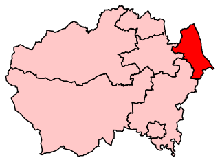
Easington is a constituency created in 1950 represented in the House of Commons of the UK Parliament since 2010 by Grahame Morris of the Labour Party.
Castle Eden Dene is a Site of Special Scientific Interest and National Nature Reserve in the Easington district of County Durham, England. It is located mostly in Peterlee, between the A19 and A1086 roads.

Horden is a railway station on the Durham Coast Line, which runs between Newcastle and Middlesbrough via Hartlepool. The station, situated 10 miles 74 chains (17.6 km) south-east of Sunderland, serves the villages of Horden, Blackhall Colliery and Easington along with the town of Peterlee in County Durham, North East England. It is owned by Network Rail and managed by Northern Trains.

Blackhall Colliery railway station served the village of Blackhall Colliery in County Durham, North East England. It was located on the Durham Coast Line, north of Blackhall Rocks and south of Horden.

Shotton Bridge railway station was a railway station built by the North Eastern Railway (NER) on the route of the Hartlepool Dock & Railway (HD&R) as part of a programme of works to modernise that line and link it with the Durham & Sunderland Railway (D&SR) so as to create a railway through-route between West Hartlepool and Sunderland. On opening, the station served the relatively new village of Shotton Colliery, which grew around the nearby Shotton Grange Colliery, as well as Old Shotton on the Stockton to Sunderland turnpike road, further to the east.

Blackhall Rocks was one of two railway stations to have served the Blackhalls in County Durham, North East England, and was a stop on the Durham Coast Line. The station was poorly sited for the village that grew around Blackhall Colliery in the years following its opening and, after the opening of the more conveniently sited Blackhall Colliery station in 1936, it came to primarily serve the more southerly village of Blackhall Rocks.