Blacksville, Georgia

Last updated

Blacksville, Georgia
Henry County Georgia Incorporated and Unincorporated areas Blacksville Highlighted.svg
Location in Henry County and the state of Georgia
Coordinates: 33°25′18″N84°9′3″W / 33.42167°N 84.15083°W / 33.42167; -84.15083
Country United States
State Georgia
County Henry
Area
  Total0.1 sq mi (0.2 km2)
  Land0.1 sq mi (0.2 km2)
  Water0 sq mi (0 km2)
Elevation
886 ft (270 m)
Population
 (2000)
  Total4
  Density40/sq mi (20/km2)
Time zone UTC-5 (Eastern (EST))
  Summer (DST) UTC-4 (EDT)
FIPS code 13-08340 [1]
GNIS feature ID0331179 [2]

Blacksville is an unincorporated community in Henry County, Georgia, United States. At the 2000 census it was recorded as a census-designated place (CDP), with a population of four. It was no longer a CDP at the 2010 census.

Contents

Blacksville is named after the Black family of McDonough, Georgia. Their family were one of the early pioneers to move to the village of McDonough where Blacksville is now located. [3] The segregation-era black high school for Henry County was in Blacksville and is now used as Henry County Middle School. Most of the community was subsequently annexed by nearby McDonough.

Geography

According to the United States Census Bureau, the CDP had a total area of 0.1 square miles (0.26 km2), all land.

Major highways

Demographics

Historical population
CensusPop.Note
1980 1,521
1990 1,112−26.9%
2000 4−99.6%
source: [4]

While many people continue to live in the area formerly known as Blacksville, as of the census [1] of 2000, there were 4 people, 1 household, and 1 family residing in the CDP, down from 1,112 in 1990. The population density was 50.7 inhabitants per square mile (19.6/km2). There was one housing unit at an average density of 12.7 per square mile (4.9/km2). The racial makeup of the CDP was 75.00% White and 25.00% from two or more races. None of the population were Hispanic or Latino of any race.

The single household consisted of a married couple living together with children under the age of 18. The average household size was 4.00 and the average family size was 4.00.

In the CDP the population was spread out, with 25.0% under the age of 18, 50.0% from 25 to 44 and 25.0% from 45 to 64. The median age was 28 years. For every 100 females, there were 100.0 males. For every 100 females age 18 and over, there were 50.0 males.

The median income for a household in the CDP was $53,750, and the median income for a family was $53,750. Males had a median income of $26,250 versus $21,250 for females. The per capita income for the CDP was $13,527.

Related Research Articles

<span class="mw-page-title-main">Henry County, Georgia</span> County in Georgia, United States

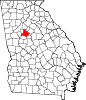
Henry County is located in the north central portion of the U.S. state of Georgia. According to the 2020 census, the population of Henry County was 240,712, up from 203,922 in 2010. The seat of government is McDonough. The county was named for Patrick Henry.

<span class="mw-page-title-main">Denali Park (CDP), Alaska</span> Census-designated place in Alaska, United States

Denali Park, formerly McKinley Park, is a census-designated place (CDP) in Denali Borough, in the U.S. state of Alaska. As of the 2020 census, the population of the CDP was 163, down from 185 at the 2010 census.

<span class="mw-page-title-main">Lowell Point, Alaska</span> Census-designated place in Alaska, United States

Lowell Point is a census-designated place (CDP) in Kenai Peninsula Borough, Alaska, United States, just outside Seward. At the 2010 census the population was 80, down from 92 in 2000.

<span class="mw-page-title-main">Kensington, Connecticut</span> Census-designated place in Connecticut, United States

Kensington is a census-designated place (CDP) and section of the town of Berlin in Hartford County, Connecticut, United States. The Berlin town offices are located in Kensington. The population was 8,459 at the 2010 census.

<span class="mw-page-title-main">Putney, Georgia</span> Place in Georgia, United States

Putney is an unincorporated community and census-designated place (CDP) in Dougherty County, Georgia, United States. The population was 2,898 at the 2010 census. It is part of the Albany, Georgia Metropolitan Statistical Area.

<span class="mw-page-title-main">Mountain Park, Gwinnett County, Georgia</span> Place in Georgia, United States

Mountain Park is an unincorporated community and census-designated place (CDP) in Gwinnett County, Georgia, United States. The population was 11,554 at the 2010 census. The older name for the area is Trickum, which is reflected in Five Forks-Trickum Road which bisects the community. The older community was centered on Five Forks and Rockbridge Roads.

<span class="mw-page-title-main">Hampton, Georgia</span> City in Georgia, United States

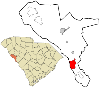
Hampton is a city in southwestern Henry County, Georgia, United States. The 2020 census was 8,368. As of the 2010 census, the city had a population of 6,987, up from 3,857 at the 2000 census. By 2018 the estimated population was 7,922. "Hampton" mailing addresses outside the city limits reach into rural parts of eastern Clayton County and northern Spalding County. It is a southeastern suburb in the Atlanta metropolitan area.

<span class="mw-page-title-main">McDonough, Georgia</span> City in Georgia, United States

McDonough is a city in Henry County, Georgia, United States. It is part of the Atlanta metropolitan area. Its population was 22,084 at the 2010 census, up from 8,493 in 2000. The city is the county seat of Henry County. The unincorporated communities of Blacksville, Flippen, Kelleytown, and Ola are located near McDonough, and addresses in those communities have McDonough ZIP Codes.

<span class="mw-page-title-main">St. James, Maryland</span> CDP in Maryland, United States

St. James is a census-designated place (CDP) in Washington County, Maryland, United States. The population was 1,657 at the 2000 census. It is also the home of St. James School, Hagerstown, a small, Episcopalian, boarding school. St. James was formerly named "Lydia."

Jaars, capitalized as JAARS on some maps, is a census-designated place (CDP) in Union County, North Carolina, United States. The population was 597 at the 2010 census. The region's name comes from JAARS, a non-profit organization that is located there.

<span class="mw-page-title-main">Narcissa, Oklahoma</span> CDP in Oklahoma, United States

Narcissa is a census-designated place (CDP) in Ottawa County, Oklahoma, United States. The population was 92 at the time of the 2020 United States census.

<span class="mw-page-title-main">Fernville, Pennsylvania</span> Census-designated place in Pennsylvania, United States

Fernville is a census-designated place (CDP) in Columbia County, Pennsylvania, United States. It is part of Northeastern Pennsylvania. The population was 481 at the 2020 census. It is part of the Bloomsburg-Berwick micropolitan area.

<span class="mw-page-title-main">Quentin, Pennsylvania</span> Census-designated place in Pennsylvania, United States

Quentin is an unincorporated community and census-designated place (CDP) in Lebanon County, Pennsylvania, United States. It was named after Quentin Roosevelt, youngest son of President Theodore Roosevelt. The population was 594 at the 2010 census, up from 529 at the 2000 census.

Renningers is a census-designated place (CDP) in Schuylkill County, Pennsylvania, United States. The population was 380 at the 2000 census.

<span class="mw-page-title-main">Princeton, South Carolina</span> Census-designated place in South Carolina, United States

Princeton is an unincorporated community and census-designated place (CDP) in Laurens County, South Carolina, United States of America. The population was 62 at the 2010 census. It is part of the Greenville–Mauldin–Easley Metropolitan Statistical Area.

<span class="mw-page-title-main">Modoc, South Carolina</span> CDP in South Carolina, United States

Modoc is a census-designated place (CDP) in McCormick County, South Carolina, United States. The population was 256 at the 2000 census, and 218 at the 2010 census, a decline of 14.8%.

<span class="mw-page-title-main">Lake McMurray, Washington</span> CDP in Washington, United States

Lake McMurray is a census-designated place (CDP) in Skagit County, Washington, United States. The population was 382 at the 2020 census. It is included in the Mount Vernon–Anacortes, Washington Metropolitan Statistical Area.

<span class="mw-page-title-main">Van Tassell, Wyoming</span> Town in Wyoming, United States

Van Tassell is a town in Niobrara County, Wyoming, United States. The population was 15 at the 2010 census.

<span class="mw-page-title-main">Calpet, Wyoming</span> Unincorporated community in Wyoming, United States

Calpet is an unincorporated community in Sublette County, Wyoming, United States. The population was 7 at the 2000 census, when it was a census-designated place (CDP).

<span class="mw-page-title-main">McKinnon, Wyoming</span> Census-designated place in Sweetwater County, Wyoming, United States

McKinnon is a census-designated place (CDP) in Sweetwater County, Wyoming, United States. The population was 60 at the 2010 census.

References

  1. 1 2 "U.S. Census website". United States Census Bureau . Retrieved January 31, 2008.
  2. "US Board on Geographic Names". United States Geological Survey. October 25, 2007. Retrieved January 31, 2008.
  3. Rainer, Vessie Thrasher (1971). Henry County,Georgia:The Mother of Counties (1st ed.). McDonough,Ga: Dr.Robert A. Rainer,Jr.
  4. "CENSUS OF POPULATION AND HOUSING (1790-2000)". U.S. Census Bureau . Retrieved July 17, 2010.