Bloxwich

Last updated

Bloxwich
Bloxwich Market - geograph.org.uk - 3539403.jpg
Bloxwich Market
Bloxwich town flag.svg
Flag
West Midlands UK location map.svg
Red pog.svg
Bloxwich
Location within the West Midlands
Population25,401 (2011 Wards) [1] [2]
OS grid reference SJ998025
Metropolitan borough
Shire county
Metropolitan county
Region
Country England
Sovereign state United Kingdom
Areas of the town
(2011 census BUASD)
List
Post town WALSALL
Postcode district WS3
Dialling code 01922
Police West Midlands
Fire West Midlands
Ambulance West Midlands
UK Parliament
List of places
UK
England
West Midlands
52°36′50″N2°00′14″W / 52.614°N 2.004°W / 52.614; -2.004

Bloxwich is a market town and civil parish in the Metropolitan Borough of Walsall, West Midlands, England. It is located between the towns of Walsall, Cannock, Willenhall and Brownhills.

Contents

St Peter's R C Church St Peter's Roman Catholic Church, Bloxwich.jpg
St Peter's R C Church

Early history

Bloxwich has its origins at least as early as the Anglo-Saxon period, when the place name evidence suggests it was a small Mercian settlement named after the family of Bloc (Bloxwich, earlier Blochescwic, meaning "Bloc's village"). [3]

All Saints Church, Bloxwich which is the parish church of the town All Saints Bloxwich.jpg
All Saints Church, Bloxwich which is the parish church of the town

Some 19th-century works suggest that at one time Bloxwich was a settlement in the ancient manor of Wednesbury. There is no conclusive evidence for this and Bloxwich has since at least medieval times been associated with the manor and town of Walsall (which for reasons unknown does not appear in the Domesday Book of 1086). Bloxwich itself is however mentioned in this book under the name 'Blockeswich'. [4] Traditionally there has been a strong rivalry between Bloxwich and Walsall with origins as early as the English Civil War, when Walsall was Parliamentarian in sympathy and Bloxwich, centre of the Foreign of Walsall, was Royalist. This situation was exacerbated by disputes over local taxation for the poor rate in the 17th and 18th centuries. [3]

18th and 19th centuries

Bloxwich grew rapidly in the 18th century around coal mining, iron smelting and various manufacturing industries, as part of the Industrial Revolution. Manufacturing in the area consisted of bridle bits, stirrups, keys, cabinet locks, plane irons, buckle tongues, chains and saddles. Its most famous product of manufacture were awl blades, which it is reputed to have surpassed all other places in the United Kingdom in manufacturing. [4] In the early 19th century, Bloxwich was still a village. Most of its inhabitants were employed in the newly founded mining and forging industries, as well as light metalworking. [ citation needed ] It is also known for its canals.

20th and 21st centuries

Bloxwich was heavily developed between the wars for council housing. Most were constructed around Blakenall Heath, as well as Harden and Goscote. In the 20 years which followed the Second World War, the Lower Farm, Beechdale and Mossley estates were also erected as council housing developments, while the southern side of Harden was developed along with the Rivers Estate at Blakenall Heath. Many privately owned houses, mostly in the Little Bloxwich area, were also constructed. In the 1990s and 2000s, many new housing developments have sprung up both in Bloxwich and at Blakenall Heath. [ citation needed ]

Bloxwich was struck by an F1/T2 tornado on 23 November 1981, as part of the record-breaking nationwide tornado outbreak on that day. [5] The tornado later moved out over Walsall town centre, causing further damage.

Bloxwich has in recent years completed numerous redevelopment projects. Bloxwich Police Station, opened in 1884 on Elmore Green Road, was closed for reconstruction in 2000, and reopened by Princess Anne on 26 September 2002. (It also has responsibility for Walsall, Willenhall and Darlaston.) The market square and library have also been refurbished.

Town centre

Bloxwich town centre is mostly made up of Victorian and Edwardian buildings and leafy parks and gardens, which maintain its origins as a Staffordshire town. Good built examples are Bloxwich Hospital, Bloxwich Hall, All Saints' Church and several private houses in Station Street, Stafford Road, Wolverhampton Street and Sandbank.

A 2013 report from the Townscape Heritage Research Unit at Oxford Brookes University states that, as a result of economic decline "the architectural quality of Bloxwich has been steadily eroded, with a high proportion of upper floor disuse and deteriorating/lost architectural detail, poor shop fronts and inappropriate advertising". [6]

From the Georgian period to the 1960s, Bloxwich had more public houses than any other town in the Metropolitan Borough of Walsall, though these have begun to disappear.[ citation needed ]

Beyond Bloxwich Golf Club, Yieldfields Hall, to the north of the town on the A34 marks the northernmost edge of Bloxwich, Walsall and the West Midlands, currently in the border with Staffordshire.

Deprivation

Bloxwich is the most deprived area of Walsall, which is itself in the 10% most deprived areas of the UK. [7] 32% of children in the north of Walsall, covering Bloxwich, Blakenall and Birchills-Leamore received free school meals in 2021. [7] Of the four areas of Walsall, the north had the highest number of children excluded from school in 2021. [7] Ofsted states that "Bloxwich West is an area of higher than average unemployment and lower than average academic achievement. Bloxwich East contains a more affluent community, with pockets of higher deprivation". [8]

Bloxwich was part of the Blakenall New Deal for Communities (NDC) area. [9] [10] A review of heritage and conservation work carried out in Bloxwich between 2001 and 2010 under the NDC and other regeneration schemes reported a "mixed" picture of progress. [6] Not all available funding had been used. [6] People did feel that they were safer in the area, and school results had improved, but the sense of community in Bloxwich was weak and "Not surprisingly, people’s hopes for their future income and job prospects are not very positive ... Bloxwich remains a challenging town in terms of quality of life, and its economic prospects". [6]

Districts

Education

Primary schools

Secondary schools

Defunct schools

R C Thomas School

Transport

Bloxwich is well-served by public transport and has two railway stations, Bloxwich and Bloxwich North. Trains from these stations are operated by West Midlands Railway.

Regular buses link Bloxwich with Walsall, whilst others link the area to the surrounding towns and cities of Wolverhampton, Bilston, Willenhall, Brownhills, Wednesfield, Cannock and Birmingham. Other local services serve nearby estates of Coalpool, Harden, Mossley, Lower Farm, Goscote, Leamore, Beechdale, Dudley Fields, Landywood, Great Wyrley and Pelsall.

The main operator of bus services in the area is National Express West Midlands, but Chaserider (formerly Arriva Midlands), Walsall Community Transport and Diamond Bus also operate on routes in the area. Notable bus routes include:

Roadwise, the A34, Southampton/Oxford/Manchester road, goes straight through the town and forms its High Street. Most shops are based on this linear development. The A4124 Wolverhampton to Brownhills road crosses to the north of the town. Bloxwich is four miles from the M6 motorway between junctions 10 and 11.

Notable residents

Related Research Articles

<span class="mw-page-title-main">Walsall</span> Market town in West Midlands County, England

Walsall is a market town and administrative centre in the West Midlands County, England. Historically part of Staffordshire, it is located 9 miles (14 km) north-west of Birmingham, 7 miles (11 km) east of Wolverhampton and 9 miles (14 km) from Lichfield.

<span class="mw-page-title-main">Metropolitan Borough of Walsall</span> Metropolitan borough in England

The Metropolitan Borough of Walsall is a metropolitan borough in the West Midlands, England. It is named after its largest settlement, Walsall, but covers a larger area which also includes Aldridge, Bloxwich, Brownhills, Darlaston, Pelsall and Willenhall.

<span class="mw-page-title-main">Wednesfield</span> Town in West Midlands, England

Wednesfield is a town and historic village in the City of Wolverhampton, West Midlands, England, It is 2 miles (3.2 km) east-northeast of Wolverhampton city centre and about 10 miles (16 km) from Birmingham and is part of the West Midlands conurbation. It was historically within the county of Staffordshire.

<span class="mw-page-title-main">Ashmore Park</span> Human settlement in England

Ashmore Park is a large housing estate in Wednesfield, England. It has been part of the city of Wolverhampton, West Midlands since 1966, when the majority of Wednesfield was incorporated into Wolverhampton. It constitutes mostly of the Wednesfield North ward of the Wolverhampton council.

<span class="mw-page-title-main">Blakenall Heath</span> Human settlement in England


Blakenall Heath is a suburban village in the Metropolitan Borough of Walsall in the West Midlands County, England. It straddles the border of Walsall and Bloxwich. Historically the village was a part of Staffordshire. It was originally a rural area between Walsall and Bloxwich with a small amount of private housing as recently as the beginning of the 20th century, but the area began to change dramatically after the end of the Great War.

<span class="mw-page-title-main">Walsall North (UK Parliament constituency)</span> Parliamentary constituency in the United Kingdom, 1955 onwards

Walsall North is a constituency created in 1955 represented in the House of Commons of the UK Parliament since 2017 by Eddie Hughes, a member of the Conservative Party.

New Invention is a large estate around three miles (4.8 km) north of the town of Willenhall and four miles (6.4 km) east of the city of Wolverhampton in the Metropolitan Borough of Walsall, West Midlands, England. It is halfway between Walsall and Wolverhampton on the busy main A4124 and A462 roads.

Harden is an area to the north of Walsall and borders with Bloxwich, Blakenall Heath, Coalpool, Goscote and Rushall. The whole area was part of the industrial revolution, with mining and metal processing being the main industries. Although close to the A34 main road from the Stoke (potteries) to Birmingham, it is still served by canals.

<span class="mw-page-title-main">Pelsall</span> Human settlement in England

Pelsall is a village and civil parish in the Metropolitan Borough of Walsall, West Midlands, England. Forming part of the borough's border with Staffordshire, Pelsall is located 4 miles north of Walsall, midway between the towns of Bloxwich and Brownhills and 4 miles northwest of Aldridge. The southern edge of Cannock Chase is 6 miles to the north. Pelsall is also 8 miles southwest of Lichfield and 8 miles northeast of Wolverhampton.

Bentley is an area in the Metropolitan Borough of Walsall located around Junction 10 of the M6 Motorway. It is also a rural village of houses towards its eastern sides. It shares borders with the areas of Willenhall, Beechdale, Ashmore Park, Pleck, Darlaston and Alumwell.

<span class="mw-page-title-main">Rushall, West Midlands</span> Suburban Village in Walsall, West Midlands, England

Rushall is a suburb in the Metropolitan Borough of Walsall in the West Midlands, England. It is centred on the main road between Walsall and Lichfield. It is mentioned in the Domesday Book but has mostly developed since the 1920s. Rushall was historically a part of the county of Staffordshire before it was incorporated with much of the old Aldridge-Brownhills Urban District into the modern-day Walsall district.

Pelsall Comprehensive School was a secondary school located in Pelsall, an area of the Metropolitan Borough of Walsall in the West Midlands of England.

The Lodge Farm estate is located in the area of Short Heath in the town of Willenhall, which is in the Metropolitan Borough of Walsall.

<span class="mw-page-title-main">Clayhanger, West Midlands</span> Human settlement in England

Clayhanger is a village in the Metropolitan Borough of Walsall in the West Midlands, England. The village is situated between Pelsall, Walsall Wood and Brownhills. The village has only one road running through it from Pelsall/Brownhills to Walsall Wood. The village has no other through roads and is predominantly residential.

<span class="mw-page-title-main">Walsall Council</span> Local government body in England

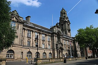
Walsall Council, formally Walsall Metropolitan Borough Council, is the local authority for the Metropolitan Borough of Walsall.

The Walsall Silver Thread Tapestries are a set of eleven artworks, in the form of tapestries, designed by the artist Hunt Emerson in conjunction with the various communities of Walsall, England and hand stitched by local people there during 2016. They depict the people, places, history and wildlife of the towns and districts that, since 1974, have formed the Metropolitan Borough of Walsall.

References

  1. "Bloxwich East Ward population 2011". Neighbourhood Statistics. Office for National Statistics. Retrieved 19 December 2015.
  2. "Bloxwich West Ward population 2011". Neighbourhood Statistics. Office for National Statistics. Retrieved 19 December 2015.
  3. 1 2 Ernest James Homeshaw (1955). The Story of Bloxwich. Geoff J. Clark Ltd. p. 281.
  4. 1 2 Edward Lees Glew (1856). History of the Borough and Foreign of Walsall. J.R. Robinson. p. 75.
  5. "European Severe Weather Database". eswd.eu. Retrieved 9 January 2023.
  6. 1 2 3 4 Reeve, Alan; Shipley, Robert (2013). "TOWNSCAPE HERITAGE INITIATIVE SCHEMES EVALUATION: Ten Year Review Report" (PDF). Heritage Fund. Oxford Brookes University. Retrieved 11 March 2022.
  7. 1 2 3 Thandi, Gurdip (24 November 2021). "Grim statistics show levels of child poverty across Walsall". Birmingham Live. Retrieved 11 March 2022.
  8. Law, Joy (2012). "Inspection report for Bloxwich Children's Centre". Ofsted. Retrieved 11 March 2022.
  9. Lucas, Karen; Tyler, Sophie; Christodoulou, Georgina (2008). "The value of new transport in deprived areas: Who benefits, how and why? An assessment of the value of new transport services to people living in deprived neighbourhoods in England" (PDF). Joseph Rowntree Foundation. University of Westminster. Retrieved 11 March 2022.
  10. Beatty, Christina; Lawless, Paul; Pearson, Sarah; Wilson, Ian (2009). "Residential mobility and outcome change in deprived areas Evidence from the New Deal for Communities Programme" (PDF). Sheffield Hallam University. Department for Communities and Local Government. Retrieved 11 March 2022.
  11. "Services & timetables". nxbus.co.uk. Retrieved 17 April 2023.
  12. "Services - West Midlands - 301: Walsall to Mossley". diamondbuses.com. Archived from the original on 18 May 2015. Retrieved 9 May 2015.
  13. "Services - West Midlands - 302: Lower Farm to Walsall". diamondbuses.com. Archived from the original on 18 May 2015. Retrieved 9 May 2015.
  14. "Pat Collins fair and cinema". Rediscover Bloxwich. 7 July 2016. Retrieved 4 October 2023.
  15. "Tom Major". Great War Theatre. Retrieved 4 October 2023.
  16. "Remembering Harold Parry – 100 years on". The Bloxwich Telegraph. 5 May 2017. Archived from the original on 6 May 2017.
  17. "Maurice Wiggin". Medlar Press. Retrieved 4 October 2023.
  18. "Phil Drabble". The Guardian. 2 August 2007. Retrieved 4 October 2023.
  19. "Not Now Arthur!". Morecambe and Wise. Retrieved 4 October 2023.
  20. "Slade's Noddy Holder gives lecture at his old school in Walsall". Express and Star. 25 February 2016. Retrieved 4 October 2023.
  21. Young, Graham (26 September 2020). "Judas Priest star says he was a panto dame 'trying to make music for everybody'". Birmingham Mail. Retrieved 4 October 2023.
  22. Ellen, Barbara (10 April 2022). "Meera Syal: 'It's a golden age for TV – the streamers have kicked us all up the arse'". The Guardian. Retrieved 4 October 2023.
  23. Phillips, Terry (28 March 2013). "Lee Naylor confident Bluebirds will get better". Wales Online. Retrieved 4 October 2023.
  24. "Facepunch Bloxwich". garry.net. 5 June 2023. Retrieved 9 August 2023.
  25. "careers at". facepunch. Retrieved 9 August 2023.

Commons-logo.svg Media related to Bloxwich at Wikimedia Commons