Bonduel, Wisconsin

Last updated

Bonduel, Wisconsin
Motto(s): 
Village of Bonduel, Gateway to Recreation
Shawano County Wisconsin Incorporated and Unincorporated areas Bonduel Highlighted.svg
Location of Bonduel in Shawano County, Wisconsin.
Coordinates: 44°44′25″N88°26′43″W / 44.74028°N 88.44528°W / 44.74028; -88.44528
Country Flag of the United States.svg  United States
State Flag of Wisconsin.svg  Wisconsin
County Shawano
Government
  Village PresidentRuss Gehm
Area
[1]
  Total2.26 sq mi (5.85 km2)
  Land2.26 sq mi (5.84 km2)
  Water0.00 sq mi (0.01 km2)
Elevation
[2]
889 ft (271 m)
Population
 (2010) [3]
  Total1,478
  Estimate 
(2019) [4]
1,417
  Density628.10/sq mi (242.54/km2)
Time zone UTC-6 (Central (CST))
  Summer (DST) UTC-5 (CDT)
Area codes 715 & 534
FIPS code 55-08725 [5]
GNIS feature ID1562052 [2]
Website http://www.villageofbonduel.com

Bonduel is a village in Shawano County, Wisconsin, United States. The population was 1,417 at the 2020 census, [6] and 1,478 at the 2010 census.

Contents

History

As founded, the community did not have an officially agreed upon name. Some early news reports called it Hartland Corners, presumably in reference to the surrounding town, named Hartland. The name Bonduel was not established for the community until an application for a post office was made in 1864, at which point "Hartland" was rejected as already being in use as a village name in Wisconsin. Therefore, the village was named Bonduel when the post office was created. [7] The village is named after a Jesuit missionary, the Rev. Florimond Bonduel, who served Wisconsin parishes and who worked with the Menominee Indians, helping them settle on their newly created reservation in 1853. [8]

Bonduel incorporated as a village in 1916. Prior to this time, administrative affairs for the community were managed by the surrounding town of Hartland. [7]

In 1964 attempts by the National Farmers Organization to get farmers to withhold their produce, milk and livestock from the market in order to boost prices resulted in the deaths of two NFO members who were run over by a cattle truck in Bonduel. [9]

Geography

Bonduel is located at 44°44′25″N88°26′43″W / 44.74028°N 88.44528°W / 44.74028; -88.44528 (44.740388, -88.445291). [10]

According to the United States Census Bureau, the village has a total area of 2.33 square miles (6.03 km2), all of it land. [11]

Demographics

Historical population
CensusPop.Note
1920 504
1930 5346.0%
1940 66123.8%
1950 74212.3%
1960 87618.1%
1970 99513.6%
1980 1,16016.6%
1990 1,2104.3%
2000 1,41617.0%
2010 1,4784.4%
2019 (est.)1,417 [4] −4.1%
U.S. Decennial Census [12]

2010 census

As of the census [3] of 2010, there were 1,478 people, 601 households, and 405 families living in the village. The population density was 634.3 inhabitants per square mile (244.9/km2). There were 645 housing units at an average density of 276.8 per square mile (106.9/km2). The racial makeup of the village was 95.4% White, 0.8% African American, 1.6% Native American, 0.4% Asian, 0.8% from other races, and 1.0% from two or more races. Hispanic or Latino of any race were 1.7% of the population.

There were 601 households, of which 34.1% had children under the age of 18 living with them, 51.7% were married couples living together, 10.5% had a female householder with no husband present, 5.2% had a male householder with no wife present, and 32.6% were non-families. 28.0% of all households were made up of individuals, and 11.8% had someone living alone who was 65 years of age or older. The average household size was 2.43 and the average family size was 2.96.

The median age in the village was 37.2 years. 26.2% of residents were under the age of 18; 7.8% were between the ages of 18 and 24; 27.3% were from 25 to 44; 22.5% were from 45 to 64; and 16.2% were 65 years of age or older. The gender makeup of the village was 49.7% male and 50.3% female.

2000 census

As of the census [5] of 2000, there were 1,416 people, 581 households, and 392 families living in the village. The population density was 645.0 people per square mile (248.5/km2). There were 598 housing units at an average density of 272.4 per square mile (104.9/km2). The racial makeup of the village was 96.68% White, 0.14% African American, 1.20% Native American, 1.13% from other races, and 0.85% from two or more races. Hispanic or Latino of any race were 1.91% of the population.

There were 581 households, out of which 33.6% had children under the age of 18 living with them, 55.9% were married couples living together, 7.1% had a female householder with no husband present, and 32.4% were non-families. 27.5% of all households were made up of individuals, and 13.9% had someone living alone who was 65 years of age or older. The average household size was 2.42 and the average family size was 2.94.

In the village, the population was spread out, with 26.2% under the age of 18, 8.0% from 18 to 24, 30.2% from 25 to 44, 18.3% from 45 to 64, and 17.3% who were 65 years of age or older. The median age was 34 years. For every 100 females, there were 96.9 males. For every 100 females age 18 and over, there were 92.8 males.

The median income for a household in the village was $39,625, and the median income for a family was $48,264. Males had a median income of $34,632 versus $21,741 for females. The per capita income for the village was $20,482. About 2.3% of families and 4.1% of the population were below the poverty line, including 3.4% of those under age 18 and 2.3% of those age 65 or over.

Images

Related Research Articles

<span class="mw-page-title-main">Shannon, Illinois</span> Village in Illinois, United States

Shannon is a village in Carroll County, Illinois, United States. The population was 801 at the 2020 census, up from 757 at the 2010 census.

<span class="mw-page-title-main">Stockbridge, Michigan</span> Village in Michigan, United States

Stockbridge is a village in Ingham County in the U.S. state of Michigan. It is located within Stockbridge Township about 36 miles (58 km) southeast from downtown Lansing. The population was 1,218 at the 2010 census.

<span class="mw-page-title-main">Hartland, Minnesota</span> City in Minnesota, United States

Hartland is a city in Freeborn County, Minnesota, United States. The population was 315 at the 2010 census.

<span class="mw-page-title-main">Hillsdale, Missouri</span> Village in Missouri, United States

Hillsdale is a village in St. Louis County, Missouri, United States. Greenwood Cemetery is located in Hillsdale. The population was 1,478 at the 2010 census.

<span class="mw-page-title-main">Royalton, New York</span> Town in New York, United States

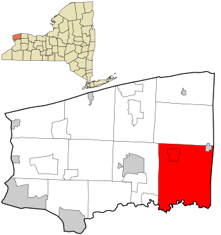
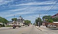
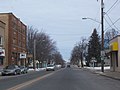
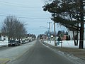
Royalton is a town in Niagara County, New York, United States. The population was 7,660 at the 2010 census.

<span class="mw-page-title-main">Shorewood Hills, Wisconsin</span> Village in Wisconsin, United States

Shorewood Hills is a village in Dane County, Wisconsin, United States. It was established in 1927. The population was 2,169 at the 2020 census. Entirely surrounded by the city of Madison and Lake Mendota, it is part of the Madison Metropolitan Statistical Area.

<span class="mw-page-title-main">Neosho, Wisconsin</span> Village in Wisconsin, United States

Neosho is a village in Dodge County, Wisconsin, United States. The population was 574 at the 2010 census.

<span class="mw-page-title-main">Dickeyville, Wisconsin</span> Village in Wisconsin, United States

Dickeyville is a village in Grant County, Wisconsin, United States. The population was 1,061 at the 2010 census.

<span class="mw-page-title-main">Alma Center, Wisconsin</span> Village in Wisconsin, United States

Alma Center is a village in Jackson County, Wisconsin, United States. The population was 503 at the 2010 census. The village is located within the Town of Alma.

<span class="mw-page-title-main">Hatley, Wisconsin</span> Village in Wisconsin, United States

Hatley is a village in Marathon County, Wisconsin, United States. It is part of the Wausau, Wisconsin Metropolitan Statistical Area. The population was 574 at the 2010 census.

<span class="mw-page-title-main">Phillips, Wisconsin</span> City in Wisconsin, United States

Phillips is a city and the county seat of Price County, Wisconsin, United States. The population was 1,478 at the 2010 census.

<span class="mw-page-title-main">Hartland, Shawano County, Wisconsin</span> Town in Wisconsin, United States

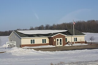
Hartland is a town in Shawano County, Wisconsin, United States. The population was 825 at the 2000 census. The unincorporated community of Slab City is located within the town. The unincorporated communities of Frazer Corners and Zachow are also located partially in the town. Hartland was established in 1859.

<span class="mw-page-title-main">Tigerton, Wisconsin</span> Village in Wisconsin, United States

Tigerton is a village in Shawano County, Wisconsin, United States. The population was 741 at the 2010 census.

<span class="mw-page-title-main">Hartland, Wisconsin</span> Village in Wisconsin, United States

Hartland is a village along the Bark River in Waukesha County, Wisconsin, United States, that is a suburb of Milwaukee. The population was 9,501 at the 2020 census.

<span class="mw-page-title-main">Oakfield, Wisconsin</span> Village in Wisconsin, United States

Oakfield is a village in Fond du Lac County, Wisconsin, United States. The population was 1,052 at the 2020 census. The village is located within the Town of Oakfield.

<span class="mw-page-title-main">Linden, Wisconsin</span> Village in Wisconsin, United States

Linden is a village in Iowa County, Wisconsin, United States. The population was 549 at the 2010 census. The village is located within the Town of Linden.

<span class="mw-page-title-main">Melrose, Wisconsin</span> Village in Wisconsin, United States

Melrose is a village in Jackson County, Wisconsin, United States. The population was 503 at the 2010 census. The village is located within the Town of Melrose.

<span class="mw-page-title-main">Elderon, Wisconsin</span> Village in Wisconsin, United States

Elderon is a village in Marathon County, Wisconsin, United States. It is part of the Wausau, Wisconsin Metropolitan Statistical Area. The population was 179 at the 2010 census.

<span class="mw-page-title-main">Star Prairie, Wisconsin</span> Village in Wisconsin, United States

Star Prairie is a village in St. Croix County in the U.S. state of Wisconsin. The population was 561 at the 2010 census. The village is located along the Apple River on the boundary between the Town of Star Prairie and the Town of Stanton.

<span class="mw-page-title-main">Merton (village), Wisconsin</span> Village in Wisconsin, United States

Merton is a village in Waukesha County, Wisconsin. The population was 3,441 at the 2020 census. It is partially within the Town of Merton.

References

  1. "2019 U.S. Gazetteer Files". United States Census Bureau. Retrieved August 7, 2020.
  2. 1 2 "US Board on Geographic Names". United States Geological Survey. October 25, 2007. Retrieved January 31, 2008.
  3. 1 2 "U.S. Census website". United States Census Bureau . Retrieved November 18, 2012.
  4. 1 2 "Population and Housing Unit Estimates". United States Census Bureau. May 24, 2020. Retrieved May 27, 2020.
  5. 1 2 "U.S. Census website". United States Census Bureau . Retrieved January 31, 2008.
  6. "Explore Census Data". data.census.gov. Retrieved May 23, 2024.
  7. 1 2 "Town of Hartland - History". www.townofhartlandwi.com. Retrieved October 4, 2016.
  8. "Bonduel - History". Archived from the original on January 5, 2009. Retrieved November 20, 2008.
  9. The History of Wisconsin, Vol. VI - Continuity and Change, 1940-1965 by William F. Thompson, State Historical Society of Wisconsin, p. 156.
  10. "US Gazetteer files: 2010, 2000, and 1990". United States Census Bureau. February 12, 2011. Retrieved April 23, 2011.
  11. "US Gazetteer files 2010". United States Census Bureau. Archived from the original on January 25, 2012. Retrieved November 18, 2012.
  12. "Census of Population and Housing". Census.gov. Retrieved June 4, 2015.