
Orchard Mesa is a census-designated place (CDP) in and governed by Mesa County, Colorado, United States. It is part of the Grand Junction, CO Metropolitan Statistical Area. The population of the Orchard Mesa CDP was 6,688 at the 2020 census. The Grand Junction post office serves the area.
Culloden is a city in Monroe County, Georgia, United States. The population was 200 in the 2020 census. It is part of the Macon Metropolitan Statistical Area.
Grandwood Park is a census-designated place (CDP) in Warren Township, Lake County, Illinois, United States. Per the 2020 census, the population was 5,297.
Long Lake is an unincorporated community and census-designated place (CDP) in Lake County, Illinois, United States. Per the 2020 census, the population was 3,663.
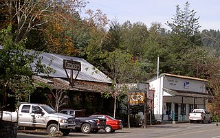
Cazadero is an unincorporated community and census-designated place (CDP) in western Sonoma County, California, United States with a population of 354 in 2010. The downtown of Cazadero consists of two churches, a general store, a post office, a hardware store, an auto repair garage, private office space, and the Cazadero Volunteer Fire Department.

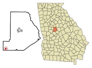
Juliette is an unincorporated community and census-designated place (CDP) in Monroe County, Georgia, United States. The community is part of the Macon Metropolitan Statistical Area. Named for Juliette McCracken, daughter of a railroad engineer, the town formed with the merging of Brownsville and Iceberg. The film Fried Green Tomatoes was filmed there, and the town has been the focal point of three popular Southern humor books. After the filming of Fried Green Tomatoes, the sets used for the town's main street were renovated into a tourist district, complete with a fully operational "Whistle Stop Cafe".
Prairietown is an unincorporated community and census-designated place (CDP) in Madison County, Illinois, United States. As of the 2020 census, it had a population of 153. It is part of the Metro East region of Greater St. Louis.
Bolingbroke, founded in 1867, is an unincorporated community and census-designated place (CDP) in Monroe County, Georgia, United States. It lies just north of Macon, between Interstates 475 and 75. The community is part of the Macon Metropolitan Statistical Area.

Nanafalia is an unincorporated community and census-designated place (CDP) in Marengo County, Alabama, United States. As of the 2020 census, its population was 75, down from 94 at the 2010 census. The community is located on a ridge above the Tombigbee River, and the name is derived from the Choctaw words for long hill. Nanafalia has a post office with a zip code of 36764.

Putnam is an unincorporated community and census-designated place (CDP) in Marengo County, Alabama, United States. As of the 2020 census, its population was 172.
Solon Mills is an unincorporated community and census-designated place in McHenry County, Illinois, United States. Solon Mills is located on U.S. Route 12, 2 miles (3.2 km) southwest of Spring Grove. Solon Mills is part of ZIP code 60071; it once had its own post office with ZIP code 60080 before it closed on September 28, 2002. It was named a CDP before the 2020 census, at which time it had a population of 133.
Elwin is an unincorporated community and census-designated place (CDP) in South Wheatland Township, Macon County, Illinois, United States. It was first listed as a CDP in 2020, with a population of 119.
Moro is an unincorporated community and census-designated place (CDP) in Madison County, Illinois, United States. As of the 2020 census it had a population of 387. Moro, like all of Madison County, is part of the Illinois Metro-East region of the Greater St. Louis metropolitan area.
Holiday Shores is an unincorporated community and census-designated place (CDP) in Madison County, Illinois, United States. Its population was 2,840 as of the 2020 census.
Twin Grove is an unincorporated community and census-designated place (CDP) in McLean County, Illinois, United States. As of the 2020 census, Twin Grove had a population of 1,524.
Cleaton is an unincorporated community and census-designated place in Muhlenberg County, Kentucky, United States. As of the 2020 census, it had a population of 168.
Cedar Springs is a census-designated place and unincorporated community in Early County, Georgia, United States. At the time of the 2020 census, the population was 75. Cedar Springs has a post office with ZIP code 39832. Georgia State Route 273 passes through the community. Georgia Pacific is 2 miles southwest from it.

Painted Hills is an unincorporated community and census-designated place (CDP) in Jackson Township, Morgan County, in the U.S. state of Indiana. Its population was 766 as of the 2020 census, up from 677 in 2010. The community is located on the shores of Lake Holiday and Lake Nebo southeast of Martinsville, the Morgan county seat. The two lakes are a combined 196 acres (79 ha) in size.
Godfrey is an unincorporated community and census-designated place in Morgan County, in the U.S. state of Georgia. It first appeared as a CDP in the 2020 Census with a population of 108.

Tazewell is an unincorporated community and census-designated place (CDP) in Marion County, in the U.S. state of Georgia.


