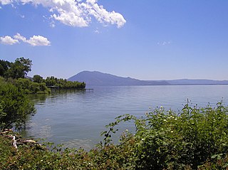
Clear Lake is a natural freshwater lake in Lake County in the U.S. state of California, north of Napa County and San Francisco. It is the largest natural freshwater lake wholly within the state, with 68 square miles (180 km2) of surface area. At an age of 2.5 million years, it is the oldest lake in North America. It is the latest lake to occupy a site with a history of lakes stretching back at least 2,500,000 years.

The Lake of the Arbuckles is a reservoir located in southern Oklahoma, 8 miles (13 km) southwest of Sulphur in Murray County. The lake covers 2,350 acres (950 ha) and is a principal water supply reservoir for the city of Ardmore, some 30 mi (48 km) to the southwest. It also supplies water to the cities of Sulphur, Davis, Wynnewood and a large oil refinery near Wynnewood. The lake also provides flood control, fish and wildlife habitat and recreation opportunities.
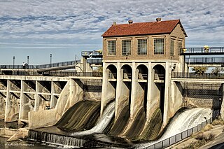
Lake Overholser is a reservoir within the city limits of Oklahoma City, Oklahoma. Lake Overholser is formed by Overholser Dam on the North Canadian River in Oklahoma County, Oklahoma. The lake is 2.9 miles (4.7 km) west of Bethany. And 4.4 mile from Yukon. Lake Overholser is named after Ed Overholser who was the 16th Mayor of the City of Oklahoma City.
Canton Lake is a lake in Blaine and Dewey Counties in Oklahoma, near Longdale and Canton. Its main source of water is the North Canadian River. It is about an hour away from Enid. The lake serves as a municipal water supply reservoir for Oklahoma City, which pays to have water released from the lake for water-supply purposes.

Fort Cobb Reservoir is a reservoir located in Caddo County in the U.S. state of Oklahoma. It impounds the waters of Cobb Creek, Lake Creek, and Willow Creek. The lake covers approximately 4,000 acres (16 km2) of water and 45 mi (72 km) of shoreline. Its drainage area is 285 square miles (740 km2). It was constructed in 1958. The towns of Carnegie, Fort Cobb, and Eakly are located nearby.
Konawa Reservoir is a reservoir located in Seminole County, Oklahoma. The lake covers approximately 1,350 acres (5.5 km2) and has a capacity of 23,000 acre-feet (28,000,000 m3). It is owned by Oklahoma Gas and Electric (OG&E) Company. and was constructed in 1968-70, to provide cooling for a nearby gas-fired electric power generation plant. It impounds Jumper Creek, about 2 miles (3.2 km) east of the city of Konawa, Oklahoma.

Lake Altus-Lugert, also known as Lake Altus, Lake Lugert, Lake Lugert-Altus, and Lugert Lake, is a reservoir located on the North Fork Red River, about 17 miles (27 km) north of Altus, Oklahoma on the former site of the town of Lugert, Oklahoma. The river is the boundary between Greer County and Kiowa County, Oklahoma. The lake is used for fishing, boating, swimming, and irrigation. This is also the principal water supply for Altus.
Lake Ellsworth is a lake in Caddo and Comanche counties in the state of Oklahoma in the United States. It was built by the City of Lawton, Oklahoma in 1962, primarily to serve as a water supply source for Lawton and the surrounding area. The nearest community is Elgin, Oklahoma.

Spruce Run Recreation Area is a 1,290-acre (5.2 km2) New Jersey state recreation area located in Union Township and Clinton Township in Hunterdon County, New Jersey, United States. It encompasses the Spruce Run Reservoir that is used as a backup reservoir to protect the state from prolonged droughts. The reservoir is the third largest in the state, after Round Valley and Wanaque Reservoir. The reservoir is used for recreation purposes, including hunting, fishing, boating and swimming.

Englebright Lake is an 815 acre reservoir on the Yuba River, impounded by Englebright Dam, in the Sierra Nevada, Northern California, United States. The reservoir stores 45,000 acre feet of water with nearly 24 miles of shoreline.
Boone Lake is a reservoir in Sullivan and Washington counties in northeastern Tennessee, formed by the impoundment of the South Fork Holston River and Watauga River behind Boone Dam.
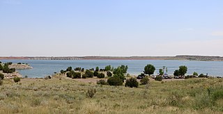
Lake Pueblo State Park is a state park located in Pueblo County, Colorado. It includes 60 miles (97 km) of shoreline and 10,000 acres (40 km2) of land. Activities it offers include two full-service marinas, recreational fishing, hiking, camping and swimming at a special swim beach.
Lake W. R. Holway, or Chimney Rock Lake is a reservoir in Mayes County, Oklahoma on the Saline Creek arm of Lake Hudson (Oklahoma). It was created in 1968 by the Grand River Dam Authority (GRDA) as an integral part of the Salina Pumped Storage Project. It is northeast of Locust Grove and southeast of Salina, Oklahoma. Originally named Chimney Rock Lake, it was renamed in 1981 to honor W. R. Holway, the consulting engineer who was responsible for constructing the Spavinaw Water Project, Pensacola Dam, and other important projects. Its primary purpose is peak power generation.

Lake Alan Henry is a reservoir situated in the upper Brazos River Basin in the United States. Created by the construction of the John T. Montford Dam in 1993, it is operated and used as a future tertiary water supply by the city of Lubbock, Texas and serves as a recreational spot for the region of West Texas. The surface area of the lake is 2,880 acres (1,170 ha) with a mean depth of 40 ft (12 m). Lake Alan Henry is located 4 mi (6.4 km) east of Justiceburg, Texas, and 45 mi (72 km) south of Lubbock.
Lake Elmer is a reservoir in Kingfisher County, Oklahoma that is owned by the Oklahoma Department of Wildlife Conservation. The nearest town is Kingfisher, about 4 miles (6.4 km) southeast of the lake. Constructed in 1962, it was completely drained in 1978 for deepening the shoreline and constructing fishing jetties. It was reimpounded and restocked with fish, after a fish kill in 1979. It has a surface area of 60 acres (24 ha) and a shoreline of 3.4 miles (5.5 km). Its elevation is 1,119 feet (341 m). The latitude and longitude are 35.8798, -97.9878. It has an average depth of 6 feet (1.8 m) and a maximum depth of 18 feet (5.5 m).
Lake Jean Neustadt is a 462-acre (187 ha) artificial lake in Carter County, Oklahoma. Located 7 miles (11 km) north of Ardmore in south-central Oklahoma, Named for a local businessman, Jean Neustadt, it was completed in 1969 and is currently operated by the city of Ardmore as a water supply.
Cedar Lake is in Le Flore County, Oklahoma inside the Ouachita National Forest. Considered a part of Indian Nations National Scenic and Wildlife Area, it is about 12 miles (19 km) south of Heavener, Oklahoma, and 40 miles (64 km) west of Mena, Arkansas.
Lake Lone Chimney owned by the Tri-County Development Authority, is in Pawnee County, Oklahoma, east of Glencoe. The lake, whose dam is also known as Lower Black Bear Creek Watershed Dam 19M, also extends into southern Payne County, Oklahoma. It was built in 1980 by the Tri-County Development Authority, Pawnee County Conservancy District and the Black Bear Conservancy District, assisted by the Oklahoma Conservation Commission and the USDA Natural Resources Conservation Service (NRCS) Watershed Protection and Flood Protection Program.
Holdenville Lake, also called Lake Holdenville, is a reservoir in Hughes County, Oklahoma. Owned and operated by the City of Holdenville, Oklahoma, it supplies most of the drinking water for Hughes County. It is just 3.5 miles (5.6 km) south of Holdenville and a 1.5 hour drive from Oklahoma City.
Lake Carl Etling, elevation 4,311 feet, also called Lake Carl G. Etling and Carl Etling Lake, is located southeast of Kenton, Oklahoma in Cimarron County, Oklahoma, inside Black Mesa State Park. Fed by South Carrizo Creek, it is 159 surface acres in size and has 5 miles of shoreline. It has an average depth of 11 feet, with a maximum depth of 38 feet.


