Borders of Belgium

Last updated
Belgium-France-Luxembourg tripoint Luxemburgischer-Grenzpfahl.jpg
Belgium–France–Luxembourg tripoint
Belgium and her neighbors Be-map.png
Belgium and her neighbors

Belgium shares borders with France, Germany, Luxembourg and the Netherlands. Belgium became de facto independent from the United Kingdom of the Netherlands in 1830. Its borders were formalized between 1839 and 1843. Over the years there have been various adjustments, notably after the Treaty of Versailles (1919) when some territory was transferred to Luxembourg. There remain enclaves of Germany and the Netherlands within Belgium and enclaves of Belgium within the Netherlands.

Contents

General

Belgium obtained de facto independence from the United Kingdom of the Netherlands with the Belgian Revolution in 1830. Its extent was formalized by the Treaty of London (1839). [1] The border between Belgium and the Netherlands was only delimited by the Boundary Treaty signed in the Hague on 5 November 1842, and the Convention of Maastricht of 8 August 1843. The Hague Treaty delimited the border in general terms while the Maastricht Convention delineated the boundary with detailed descriptions and maps on a 1:10,000 or, where necessary, 1:2,500 scale. [2]

Belgium–France border

The limits of the Belgium–France border are outlined in the 1820 Treaty of Kortrijk, agreed between France and the then-United Kingdom of the Netherlands. Belgium inherited the border upon its independence. [3] Maintenance of and disputes concerning the border markers are managed by a mixed Franco-Belgian border delimitation commission, which is convened when required. A commission was convened in 2000 concerning maintenance of the 78 border markers between France and the Belgian province of West Flanders. [3]

On 4 May 2021 a border post was moved by a Belgian farmer, shifting it approximately 2.29 metres (7 ft 6 in) into France. [4]

Belgium–Luxembourg border

The border between Belgium and Luxembourg is about 148 kilometres (92 mi) long. It runs between the Belgian provinces of Luxembourg and Liège and the Luxembourg regions of Ardennes, Luxembourg City and Red Lands. There are 507 border markers along the S-shaped border. [5]

The Belgium–Luxembourg border was defined in 1839. The French-speaking part of the Grand Duchy of Luxembourg and the Arlon region were allocated to Belgium, while the German speaking part of the Grand Duchy was within the German Confederation. The border was redrawn in 1919 after the Treaty of Versailles, with the French-speaking province being transferred to Luxembourg. [5]

Belgium–Germany border

Belgium-Germany border and German enclaves Belgrenz.jpg
Belgium–Germany border and German enclaves

The border between the modern states of Belgium and Germany has a length of 136 km (85 mi). [6] [lower-alpha 1] The border runs between the Belgian region of Liege and the German regions of North Rhine-Westphalia and Rhineland-Palatinate. It runs from the Germany-Belgium-Luxembourg tripoint to the Germany-Belgium-Netherlands tripoint. There were many changes to the border demarcation until World War II. After the war ended in 1945, Belgium was given administration of the German territories of Aachen-Bildchen, Losheim and Losheimergraben. The accord of 26 September 1956 returned these towns to Germany. [1]

The Vennbahn was a railway line built in Germany close to the Belgian border. When the areas of Eupen, Malmedy and St. Vith became part of Belgium as a result of the Versailles Treaty, a strip 5 metres (16 ft) wide along the railway line became Belgian territory. Some of the land to the west of the line remained German in five small enclaves. From north to south they are named Munsterbildchen, Rötgener Wald, Rückschlag, Mützenich and Ruitzhof. [7] A sixth German enclave to the south, Hemmeres, was also cut off by a railway line, but it was handed back to Germany in 1956. [8]

Belgium–Netherlands border

A total of 365 border posts were erected to indicate the border between Belgium and the Netherlands after it was agreed in 1843. [2] While the two treaties resulted in the finalisation and demarcation of the main border between the two countries, they left the complicated territorial situation in Baarle unresolved. The current Belgian enclaves as well as Dutch counter-enclaves have resulted in what has been called the world's most complicated international boundary. [9] This is a continuation of land ownership from the feudal age. Several subsequent negotiations failed to resolve the territorial issues here. [2]

Notes

  1. When the German enclaves in Belgium are included, the border is 167 kilometres (104 mi) long. [1]

Related Research Articles

<span class="mw-page-title-main">Foreign relations of Belgium</span>

Belgium is a country in Europe and member of major international organizations like the European Union and NATO which are both headquartered in Brussels, Belgium.

<span class="mw-page-title-main">Baarle-Hertog</span> Municipality in Flemish Community, Belgium

Baarle-Hertog is a Flemish municipality of Belgium, much of which consists of a number of small Belgian enclaves fully surrounded by the Netherlands.

<span class="mw-page-title-main">Southern Netherlands</span> Historical region in Belgium

The Southern Netherlands, also called the Catholic Netherlands, were the parts of the Low Countries belonging to the Holy Roman Empire which were at first largely controlled by Habsburg Spain and later by the Austrian Habsburgs until occupied and annexed by Revolutionary France (1794–1815).

<span class="mw-page-title-main">German-speaking Community of Belgium</span> One of three federal communities of Belgium

The German-speaking Community also known as East Belgium, is one of the three federal communities of Belgium, with an area of 854 km2 (330 sq mi) in the Liège Province of Wallonia, including nine of the eleven municipalities of Eupen-Malmedy. Traditionally speakers of Limburgish, Ripuarian and Moselle Franconian varieties; the population numbers 77,949 – about 7.0% of Liège Province and about 0.7% of the national total.

<span class="mw-page-title-main">Our (river)</span> River in Belgium, Germany and Luxembourg

The Our is a river in Belgium, Luxembourg and Germany. It is a left-hand tributary of the river Sauer/Sûre. Its total length is 78 kilometres (48 mi).

<span class="mw-page-title-main">Tripoint</span> Geographical point at which the boundaries of three countries or subnational entities meet

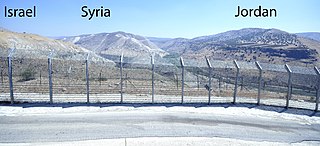
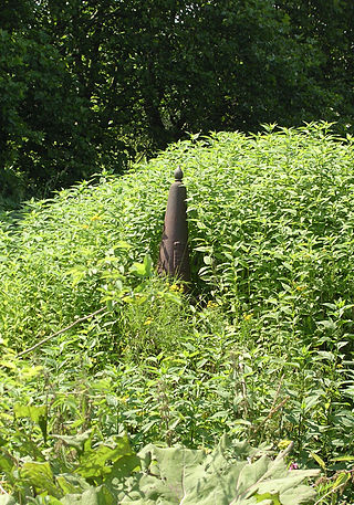
A tripoint, trijunction, triple point, or tri-border area is a geographical point at which the boundaries of three countries or subnational entities meet. There are 175 international tripoints as of 2020. Nearly half are situated in rivers, lakes or seas. On dry land, the exact tripoints may be indicated by markers or pillars, and occasionally by larger monuments.

<span class="mw-page-title-main">Belgium–Luxembourg Economic Union</span> Economic union between Belgium and Luxembourg

The Belgium–Luxembourg Economic Union, abbreviated to BLEU or UEBL, is an economic union between Belgium and Luxembourg, two countries in the Benelux Union.

<span class="mw-page-title-main">Enclave and exclave</span> Territory (or part of one) entirely surrounded by the territory of one other state

An enclave is a territory that is entirely surrounded by the territory of one other state or entity. Enclaves may also exist within territorial waters. Enclave is sometimes used improperly to denote a territory that is only partly surrounded by another state. Vatican City and San Marino, both enclaved by Italy, and Lesotho, enclaved by South Africa, are completely enclaved sovereign states.

<span class="mw-page-title-main">Partitions of Luxembourg</span> Losses of territory of the Grand Duchy of Luxembourg

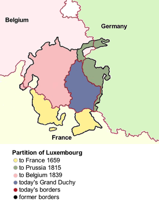
There were three Partitions of Luxembourg between 1659 and 1839. Together, the three partitions reduced the territory of the Duchy of Luxembourg from 10,700 km2 (4,100 sq mi) to the present-day area of 2,586 km2 (998 sq mi) over a period of 240 years. The remainder forms parts of modern-day Belgium, France, and Germany.

<span class="mw-page-title-main">Vennbahn</span> Former railway line in Northern Europe

The Vennbahn is a former railway line that was built partly across what was then German territory by the Prussian state railways. It is now entirely in Belgium, because the trackbed of the line, as well as the stations and other installations, were made provisional Belgian territory in 1919 under an article of the Treaty of Versailles.

<span class="mw-page-title-main">Territorial evolution of Germany</span>

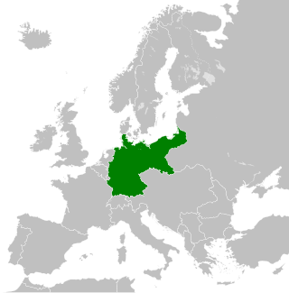
The territorial evolution of Germany in this article include all changes in the modern territory of Germany from its unification making it a country on 1 January 1871 to the present although the history of "Germany" as a territorial polity concept and the history of the ethnic Germans are much longer and much more complex. Modern Germany was formed when the Kingdom of Prussia unified most of the German states, with the exception of multi-ethnic Austria, into the German Empire. After the First World War, on 10 January 1920, Germany lost about 10% of its territory to its neighbours, and the Weimar Republic was formed two days before this war was over. This republic included territories to the east of today's German borders.

<span class="mw-page-title-main">1996 France–United Kingdom Maritime Delimitation Agreements</span>

The 1996 France – United Kingdom Maritime Delimitation Agreements are two treaties between France and the United Kingdom which establish a number of maritime boundary between French territories and British territories in the Caribbean Sea.

<span class="mw-page-title-main">Belgium–France border</span> International border

The Belgium–France border, or more commonly the Franco-Belgian border, separates France and Belgium and is 620 km (390 mi) long. Part of it is defined by the Lys river. The western end is at the North Sea. The eastern end is at the Belgium–France–Luxembourg tripoint. The straight distance between these points is 289 km (180 mi).

After the defeat of Nazi Germany in World War II in 1945, Belgium planned to annex parts of the territory along the Belgian–German border. In addition to monetary compensations and the lending of labour forces, this was considered a way of reparations. In mid-April 1949, Belgium surprisingly waived any interest in most of the previously claimed areas.

<span class="mw-page-title-main">France–Germany border</span> International border

The France–Germany border separates France and Germany and has a length of 450 km (280 mi), about half of it along the Rhine.

<span class="mw-page-title-main">Belgium–Netherlands border</span> International border

The Belgium–Netherlands border separates Belgium and the Netherlands and is 450 km (280 mi) long.

<span class="mw-page-title-main">Germany–Netherlands border</span> International border

The Germany–Netherlands border consists of a 570-kilometre (350 mi) land and maritime border across the Dollart through the Frisian Islands into the North Sea.

<span class="mw-page-title-main">Belgium–Germany border</span> International border

The border between the modern states of Belgium and Germany has a length of 204 km (127 mi).

<span class="mw-page-title-main">Greater Belgium</span>

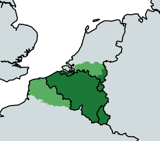
Greater Belgium is a Belgian irredentist concept which lays claim on territory nationalists deem as rightfully Belgian. It usually laid claim to: German territory historically belonging to the former Duchy of Limburg (Eupen-Malmedy), Dutch Limburg, Zeelandic Flanders, and the Grand Duchy of Luxembourg. To a lesser degree, they also claimed the Dutch province of North Brabant and the French Netherlands (Nord-Pas-de-Calais). Shortly after the Belgian Revolution, some groups even proposed a Belgo-Rhine federation. Nowadays, belief in Belgian irredentism is very uncommon and overshadowed by talk of partitioning Belgium or the incorporation of Flanders into the Netherlands.

The France–Luxembourg border stretches 73 kilometers in length, to the northeast of France and to the south of Luxembourg.

References

  1. 1 2 3 Border: Belgium-Germany MOT.
  2. 1 2 3 Randall Lesaffer 2016.
  3. 1 2 Question nº 309 de M. Vandenbroeke.
  4. Belgian farmer accidentally moves French border.
  5. 1 2 Border: Belgium-Luxembourg MOT.
  6. Länge der Grenzen von Deutschland...
  7. Jan S. Krogh.
  8. Die Bahn blieb belgisch.
  9. Kaid Benfield 2012.

Sources