History
Early history
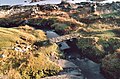
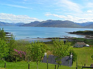
Boreraig, lying in a green and fertile glen, sheltered and south-facing, [1] is an of a traditional, pre-crofting baile or township. It was forcibly cleared by the agents of Lord MacDonald to make way for sheep in 1853.
Many of the inhabitants, mainly crofters, emigrated after they were evicted. [2] The Scottish census reveals that, by 1851, in the parish of Strath, Shire of Inverness, approximately one hundred and twenty men, women and children lived in Boreraig's 22 households. Not every adult's occupation was recorded, but where the census taker kept a record, he described most individuals as crofters, agricultural labourers, or farm servants. Among them he also recorded a few weavers, a fisherman, and a house carpenter.
Croft tenancy records dating back to 1823, now held by the Clan Donald Centre at the Armadale Museum of the Isles in Sleat on the Isle of Skye, indicate that the twenty two households were spread across ten landholdings, each of 6 acres (2.4 hectares). [3] Many of the inhabitants were related. Anglicised death records indicate a good number of the inhabitants had maternal or paternal forebears born with the surname MacInnes.
The Boreraig evictions coincided with the high water mark of the Highland and Island Emigration Society. [4] During the few years of operation, the scheme resettled some 5000 highlanders and islanders in Australia. By 1853, the HIES had accepted at least eight of Boreraig's 22 households, or just under half the occupants of the cleared village, for sponsored resettlement. [5]
In 1852 families from three Boreraig households sailed on the Araminta, the Allison, and the Ontario. Late in the same year, five more Boreraig households set out to emigrate with the HIES. The berths allocated to them were on HMS Hercules. Fever broke out on board. Passengers were dying before the ship reached Ireland. [6]
If other Boreraig families had been accepted for HIES resettlement, they decided not to take up the HIES option.
Clan Donald records indicate approximately seven of the household listed as 1852 Boreraig tenants (whether solely or jointly) eventually ended up as tenants of crofts in other villages. Scottish General Registry Office records confirm this. [7]
Modern era
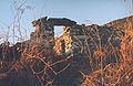
All that is left in Boreraig now is the ruined housing, much of it still standing to wallhead height, and the well-preserved field walls. [8] The biggest ruins are those of the house and steading built for the tenant-farmer. The village lost its last residents in 1877. [1] Scottish Gaelic was the language of the inhabitants.
The sheep farmhouse was abandoned in 1910. [1] However the land is still used for grazing a flock of approximately 300 breeding ewes of the North Country Cheviot breed, which are hefted onto the area and run from Kilbride. Boreraig cannot be reached by any vehicular transport at all, thus making winter feed supplementation impossible, but the township has some of the most fertile grassland in Strath Swordale so the sheep remain in reasonable condition.
There is a standing stone and a remarkable footbridge over a stream consisting of a single slab of stone, which is said to have been lifted into place by one man - "Glagan-glùine" or "Knock-knees", who was alive in the early 18th century. [9] The remains of a promontory dun and an anchorage can be seen.
There is a very popular circular walk of about 8–9 miles (13–14.5 kilometres), starting and finishing at Kilchrist (Cill Chrìosda or Cill a' Chrò), taking in Boreraig, neighbouring Suisnish (Suidhisnis) and Kilbride (Cille Bhrìghde).
The land today, like much of Strath Swordale, is owned by the Scottish Government.

The Highlands is a historical region of Scotland. Culturally, the Highlands and the Lowlands diverged from the Late Middle Ages into the modern period, when Lowland Scots language replaced Scottish Gaelic throughout most of the Lowlands. The term is also used for the area north and west of the Highland Boundary Fault, although the exact boundaries are not clearly defined, particularly to the east. The Great Glen divides the Grampian Mountains to the southeast from the Northwest Highlands. The Scottish Gaelic name of A' Ghàidhealtachd literally means "the place of the Gaels" and traditionally, from a Gaelic-speaking point of view, includes both the Western Isles and the Highlands.

North Uist is an island and community in the Outer Hebrides of Scotland.

The first Highland Land League emerged as a distinct political force in Scotland during the 1880s, with its power base in the country's Highlands and Islands. It was known also as the Highland Land Law Reform Association and the Crofters' Party. It was consciously modelled on the Irish Land League.

Crofting is a form of land tenure and small-scale food production particular to the Scottish Highlands, the islands of Scotland, and formerly on the Isle of Man. Within the 19th-century townships, individual crofts were established on the better land, and a large area of poorer-quality hill ground was shared by all the crofters of the township for grazing of their livestock. In the 21st century, crofting is found predominantly in the rural Western and Northern Isles and in the coastal fringes of the western and northern Scottish mainland.
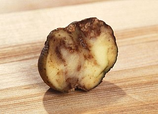
The Highland Potato Famine was a period of 19th-century Highland and Scottish history over which the agricultural communities of the Hebrides and the western Scottish Highlands saw their potato crop repeatedly devastated by potato blight. It was part of the wider food crisis facing Northern Europe caused by potato blight during the mid-1840s, whose most famous manifestation is the Great Irish Famine, but compared with its Irish counterpart, it was much less extensive and took many fewer lives as prompt and major charitable efforts by the rest of the United Kingdom ensured relatively little starvation. The terms on which charitable relief was given, however, led to destitution and malnutrition amongst its recipients. A government enquiry could suggest no short-term solution other than reduction of the population of the area at risk by emigration to Canada or Australia. Highland landlords organised and paid for the emigration of more than 16,000 of their tenants and a significant but unknown number paid for their own passage. Evidence suggests that the majority of Highlanders who permanently left the famine-struck regions emigrated, rather than moving to other parts of Scotland. It is estimated that about a third of the population of the western Scottish Highlands emigrated between 1841 and 1861.
The Napier Commission, officially the Royal Commission of Inquiry into the Condition of Crofters and Cottars in the Highlands and Islands was a royal commission and public inquiry into the condition of crofters and cottars in the Highlands and Islands of Scotland.

A croft is a traditional Scottish term for a fenced or enclosed area of land, usually small and arable, and usually, but not always, with a crofter's dwelling thereon. A crofter is one who has tenure and use of the land, typically as a tenant farmer, especially in rural areas.

Strathnaver or Strath Naver is the fertile strath of the River Naver, a famous salmon river that flows from Loch Naver to the north coast of Scotland. The term has a broader use as the name of an ancient province also known as the Mackay Country, once controlled by the Clan Mackay and extending over most of northwest Sutherland.

Tarskavaig is a crofting village on the west coast of Sleat on the Isle of Skye in Scotland. It sits in a glen which meets Tarskavaig Bay and lies opposite the Isles of Eigg, Rum and Canna. It is often said that Tarskavaig has the best view of the Cuillin in Skye.
Torrin is a settlement on the island of Skye in Scotland.
Strathrusdale Glen in the Highlands of Scotland forming the western part of the area known as Ardross. The Strath runs east to west for 2.5 miles and the river Blackwater flows through it to merge at the eastern end with another tributary to form the River Alness. The floor of the strath is mainly fields used for sheep grazing. The strath is surrounded by commercial pine forest, except to the north, which is dominated by the mountain Beinn Tharsuinn (2831 ft). Traditionally the strath was populated by tenant crofters, however in recent years there has been an increase in the number of new homes and restorations, after many decades of gradual decline.

Camustianavaig is a crofting township on the island of Skye in Scotland. It is located on the shores of the Sound of Raasay, 5 kilometres southeast of Portree. The Lòn Bàn watercourse flows from Loch Fada to "An Eas Mhòr" below which it is named "Allt Ósglan" and discharges into the sea at Camas Tianabhaig. The stream forms the boundary between the township and Conordan to the south. Ósglan itself is the land on the right bank of Allt Ósglan.
Camuscross is a small crofting township on the Isle of Skye in Scotland.

The Isle of Skye, or simply Skye, is the largest and northernmost of the major islands in the Inner Hebrides of Scotland. The island's peninsulas radiate from a mountainous hub dominated by the Cuillin, the rocky slopes of which provide some of the most dramatic mountain scenery in the country. Although Sgitheanach has been suggested to describe a winged shape, no definitive agreement exists as to the name's origins.

The Highland Clearances were the forced evictions of a significant number of tenants in the Scottish Highlands and Islands, mostly in two phases from 1750 to 1860.

Drumfearn is a small crofting township, lying at the head of the Sleat peninsula, at the head of Loch Eishort, on the isle of Skye in the Highalnds of Scotland and is in the Scottish council area of Highland.

Glendale is a community-owned estate on the north-western coastline of the Duirinish peninsula on the island of Skye and is in the Scottish council area of Highland. The estate encompasses the small crofting townships of Skinidin, Colbost, Fasach, Glasphein, Holmisdale, Lephin, Hamaraverin, Borrodale, Milovaig, Waterstein, Feriniquarrie, Totaig, Hamara, and others.

Cill Chriosd or Kilchrist is a ruined former parish church of Strath, on the Isle of Skye, Scotland. It was constructed around the 16th century, replacing an earlier medieval church on the same location, and was used until 1840 when the parish church was relocated to Broadford. It lies on the B8083 Broadford to Torrin and Elgol road.

Kilbride is a small township in Strath Swordale, Isle of Skye, Scotland.

Lochalsh is a district of mainland Scotland that is currently part of the Highland council area. The Lochalsh district covers all of the mainland either side of Loch Alsh - and of Loch Duich - between Loch Carron and Loch Hourn, ie. from Stromeferry in the north on Loch Carron down to Corran on Loch Hourn and as (south-)west as Kintail. It was sometimes more narrowly defined as just being the hilly peninsula that lies between Loch Carron and Loch Alsh. The main settlement is Kyle of Lochalsh, located at the entrance to Loch Alsh, opposite the village of Kyleakin on the adjacent island of Skye. A ferry used to connect the two settlements but was replaced by the Skye Bridge in 1995.