Bounty Islands

Last updated

Bounty Islands
Moutere Hauriri (Māori)
Bounty Islands Sub-Antarctic New Zealand Panorama 1.jpg
Panorama of a seabird colony on Proclamation Island, part of the Bounty Islands
Bounty Islands New Zealand geographic map en.svg
Map of the Bounty Islands
Pacific Ocean laea relief location map.jpg
Red pog.svg
Bounty Islands
Location of the Bounty Islands within the Pacific Ocean
Geography
Coordinates 47°45′S179°03′E / 47.750°S 179.050°E / -47.750; 179.050
Area1 [lower-alpha 1]  km2 (0.39 sq mi)
Highest elevation73 m (240 ft)
Administration
Flag of New Zealand.svg New Zealand
Demographics
Population0

The Bounty Islands (Māori : Moutere Hauriri; "Island of angry wind") are a small group of uninhabited granite islets and numerous rocks, with a combined area of circa 50 ha (120 acres) in the South Pacific Ocean. Territorially part of New Zealand, they lie about 670 km (420 mi) east-south-east of New Zealand's South Island, 530 km (330 mi) south-west of the Chatham Islands, and 215 km (134 mi) north of the Antipodes Islands. The group is a World Heritage Site. [4]

Contents

The islands are listed with the New Zealand Outlying Islands. The islands are an immediate part of New Zealand, but not part of any region or district. Rather, they are listed as an Area Outside Territorial Authority, similar to all other outlying islands except for the Solander Islands / Hautere.

History

Captain William Bligh discovered the Bounty Islands en route from Spithead to Tahiti in 1788, and named them after his ship HMS Bounty, just months before the famous mutiny. The location of the islands were only roughly marked on charts. In early 1866 Commander W. H. Norman of HMVS Victoria (1855) was tasked with determining more accurately their position. He reported them as being latitude 47°50' South and longitude 179°00' East. [5] Captain George Palmer, during the search for the Matoaka , placed the islands at 47°46'24" South 178°56'45" East. Palmer also annexed the islands for New Zealand. [6]

During the 19th century the area was a popular hunting-ground for sealers. [7] The islands were also searched from time to time for missing ships and crews, including those from the General Grant and the Matoaka. [8]

The Hinemoa visited the islands in March 1886 and erected a depot for marooned sailors on the largest island. Captain Fairchild noted that there was no fresh water available on these islands. [9] The depot had been destroyed by the sea by the time the Stella visited the island in 1887. [10] A new Admiralty chart 1022 was issued for the area in 1888, which took into account survey work undertaken by the Hinemoa.

In November 1891 the Hinemoa returned to the islands and built a fresh provisions storage. [11]

Pacificana cockayni spider from Proclamation Island (subadult male) Pacificana cockayni adult male Bounty Islands New Zealand.jpg
Pacificana cockayni spider from Proclamation Island (subadult male)

Flora and fauna

Ecologically, the islands are part of the Antipodes Subantarctic Islands tundra ecoregion. Plants include Cook's scurvy grass. The group is home to an endemic spider Pacificana cockayni , [12] endemic insects, and large numbers of seabirds.

Important Bird Area

The Bounty group has been identified as an Important Bird Area (IBA) by BirdLife International because of its significance as a breeding site for erect-crested penguins, Salvin's albatrosses and Bounty shags. [13]

Geography

The whole chain is only 5 km (3.1 mi) across at its longest axis, and comprises three subgroups: the Main Group, the Centre Group, and the East Group. The total area is only 1.35 km2 (0.52 sq mi). The islands are at the antipodes of Bouillé-Ménard, in France (Pays de la Loire).

The Main Group is the largest of the three groups, and is located in the northwest of the chain. It includes the group's largest island, Depot Island, which is around 700 metres in length and 400 metres across at its widest point. Proclamation and Tunnel Islands are separated from Depot Island by only a narrow cleft, and are joined to it at low tide. A small islet off the north coast of this group's Spider Island is the chain's northernmost point; the westernmost point is the western tip of Penguin Island. [14]

The Centre Group is located some 1.5 to 2 kilometres to the southeast of the Main Group, and contains three main islands, arrayed in a north–south line. A smaller islet lies immediately to the west. The northernmost of the Centre Group, Funnel Island, contains the chain's highest point, at 73 m (240 ft) above sea level. [15] A further 1.5 kilometres to the east is the East Group, which is also arrayed roughly in a north–south line. The largest island in this group, Molly Cap, is the group's southernmost island, and contains the chain's second-highest point, 70 m (230 ft) above sea level. This group contains two large islets and one small islet, along with several reefs and stacks, one of which is the easternmost point in the chain. [14]

Islands

The following table includes named islands according to Land Information New Zealand. [2]

LocationArea
(ha)
Group
Depot Island 13.0Main
Ruatara Island5.5
Penguin Island5.1
Lion Island4.8
Spider Island4.7
Proclamation Island3.4
Tunnel Island1.7
Ranfurly Island1.4
Skua Rock0.7
Seal Rock0.5
unnamed0.2
Dog Rock0.2
Main Group41.2
Funnel Island2.7Centre
Prion Island1.2
Castle Island0.7
Coronet Island0.3
Centre Group5.0
Molly Cap2.4East
North Rock0.9
Con Island0.4
East Group3.9
Total
50.2

See also

Notes

  1. The Department of Conservation (New Zealand) gives a "total land mass" of 1.35 km2 [1] while Land Information New Zealand gives both 1.35 km2 or 0.5 km2 depending on the dataset. [2] [3]

Related Research Articles

<span class="mw-page-title-main">Auckland Islands</span> Volcanic archipelago in New Zealand

The Auckland Islands are an archipelago of New Zealand, lying 465 km (289 mi) south of the South Island. The main Auckland Island, occupying 460 km2 (180 sq mi), is surrounded by smaller Adams Island, Enderby Island, Disappointment Island, Ewing Island, Rose Island, Dundas Island, and Green Island, with a combined area of 570 km2 (220 sq mi). The islands have no permanent human inhabitants.

<span class="mw-page-title-main">Dusky Sound</span> Fiord on New Zealands South Island

Tamatea / Dusky Sound is a fiord on the southwest corner of New Zealand, in Fiordland National Park.

<span class="mw-page-title-main">Snares Islands</span> Island group in New Zealand

The Snares Islands, known colloquially as The Snares, is a group of uninhabited islands lying about 200 km (120 mi) south of New Zealand's South Island and to the south-southwest of Stewart Island / Rakiura. The Snares consist of the main North East Island and the smaller Broughton Island and Alert Stack, as well as the Western Chain Islands some 5 km (3.1 mi) to the west-southwest. Collectively, the Snares have a total land area of 3.4 km2 (1.3 sq mi).

<span class="mw-page-title-main">Antipodes Islands</span> Subantarctic archipelago of New Zealand

The Antipodes Islands are inhospitable and uninhabited volcanic islands in subantarctic waters to the south of – and territorially part of – New Zealand. The 21 km2 (8.1 sq mi) archipelago lies 860 km (530 mi) to the southeast of Stewart Island/Rakiura, and 730 km (450 mi) to the northeast of Campbell Island. They are very close to being the antipodal point to Normandy in France, meaning that the city farthest away is Cherbourg-en-Cotentin, France.

<span class="mw-page-title-main">New Zealand Subantarctic Islands</span> Southernmost parts of the South Pacific country

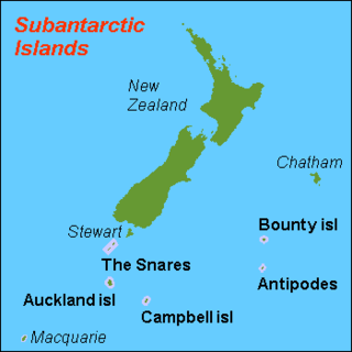
The New Zealand Subantarctic Islands comprise the five southernmost groups of the New Zealand outlying islands. They are collectively designated as a UNESCO World Heritage Site.

<span class="mw-page-title-main">Campbell Islands</span> Island group in New Zealand

The Campbell Islands are a group of subantarctic islands, belonging to New Zealand. They lie about 600 km south of Stewart Island. The islands have a total area of 113 km2 (44 sq mi), consisting of one big island, Campbell Island, and several small islets, notably Dent Island, Isle de Jeanette Marie, Folly Island, Jacquemart Island, and Monowai Island. Ecologically, they are part of the Antipodes Subantarctic Islands tundra ecoregion. The islands are one of five subantarctic island groups collectively designated as a World Heritage Site by UNESCO.

<span class="mw-page-title-main">Subantarctic snipe</span> Species of bird

The Subantarctic snipe is a species of snipe endemic to New Zealand's subantarctic islands. The Maori call it "Tutukiwi". The nominate race C. a. aucklandica is found on the Auckland Islands. Other subspecies include C. a. meinertzhagenae from the Antipodes Islands, and C. a. perseverance from Campbell Island / Motu Ihupuku. The former subspecies from the Snares Islands has been separated as a full species, the Snares snipe, as have the extinct South Island and North Island snipes.

<span class="mw-page-title-main">Bollons Island</span> Island in Antipodes Islands group

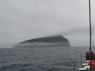
Bollons Island is a small island in New Zealand's subantarctic Antipodes Islands group. It is the second largest island in the group behind Antipodes Island.

<span class="mw-page-title-main">Campbell Plateau</span> Large oceanic plateau south of New Zealand and the Chatham Rise

The Campbell Plateau is a large oceanic plateau south of New Zealand and the Chatham Rise. It originated in the Gondwanan breakup and is part of Zealandia, a largely submerged continent. The above sea level parts of the plateau — the Bounty Islands, Antipodes Islands, Auckland Islands and Campbell Island — form part of the New Zealand Subantarctic Islands which were declared a World Heritage Site in 1998. Large parts of the Campbell Plateau lie less than 1000 m below sea level. It rises to 500 m at the Pukaki Rise and emerges above sea level at the Auckland and Campbell Islands.

The Tītī / Muttonbird Islands are an island group near Stewart Island in the far south of New Zealand. The islands are not permanently inhabited, and are named for the traditional seasonal harvesting ("muttonbirding") of the sooty shearwater by Māori. These birds are known as "muttonbirds" due to their supposedly mutton-like taste.

<i>Dundonald</i> (ship) Former British barque

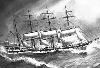
Dundonald was a British four-masted steel barque measuring 2,205 gross register tons launched in Belfast in 1891. It was involved in a wreck in 1907 in the New Zealand Subantarctic Islands. Only 15 of its 28 crew survived; they were rescued seven months later by a scientific expedition.

<span class="mw-page-title-main">Castaway depot</span> Hut or store used to aid persons lost at sea

A castaway depot is a store or hut placed on an isolated island to provide emergency supplies and relief for castaways and victims of shipwrecks.

NZGSS <i>Hinemoa</i>

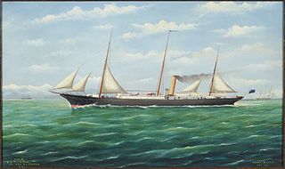
NZGSS Hinemoa was a 542-ton New Zealand Government Service Steamer designed specifically for lighthouse support and servicing, and also for patrolling New Zealand's coastline and carrying out castaway checks and searching for missing ships. It operated in New Zealand's territorial waters from 1876 to 1944.

<span class="mw-page-title-main">John Bollons</span>

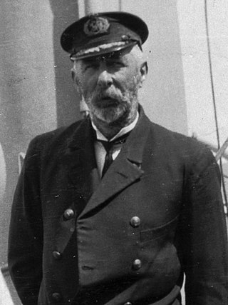
John Peter Bollons was a New Zealand marine captain, naturalist and ethnographer. For many years he captained New Zealand government steamers, including the NZGSS Hinemoa, which undertook lighthouse work and patrols through New Zealand's subantarctic islands. Bollons Island, in the Antipodes Islands, is named after him. In 1928 he was appointed a Companion of the Imperial Service Order.

The Antipodes snipe, also known as the Antipodes Island snipe, is an isolated subspecies of the Subantarctic snipe that is endemic to the Antipodes Islands, a subantarctic island group south of New Zealand in the Southern Ocean.

Matoaka was a 1092-ton wooden New Brunswick full-rigged ship built in 1853 for Willis, Gunn, & Co. She was sold to Shaw, Savill, & Albion by 1859. Between 1859 and 1869 she made eight voyages to New Zealand. Her fastest run from Bristol to Lyttelton, New Zealand was 82 days in 1862. On 13 May 1869 she left Lyttelton for London under Captain Alfred Stevens with 45 passengers and 32 crew but was never seen again. In 1865 she was classed as 1322 tons.

<span class="mw-page-title-main">Moutere Ihupuku / Campbell Island Marine Reserve</span>

Moutere Ihupuku / Campbell Island Marine Reserve or Campbell Island / Moutere Ihupuku Marine Reserve is a marine reserve around Campbell island in the New Zealand Subantarctic Islands.

<span class="mw-page-title-main">Moutere Mahue / Antipodes Island Marine Reserve</span> Marine reserve in New Zealand territorial waters

Moutere Mahue / Antipodes Island Marine Reserve is a marine reserve covering an area of 217,287 hectares around the Antipodes Islands south of New Zealand's South Island and Stewart Island / Rakiura. It was established in 2014 and is administered by the New Zealand Department of Conservation.

Moutere Hauriri / Bounty Islands Marine Reserve is a marine reserve covering an area of 104,626 hectares around New Zealand's Bounty Islands. It was established in 2014 and is administered by the Department of Conservation.

<span class="mw-page-title-main">Depot Island (Bounty Islands)</span> Island in the Bounty Islands, New Zealand

Depot Island is the largest island in the Bounty Islands, a chain of uninhabited subantarctic islands 800 kilometres off the southeast coast of New Zealand's South Island. The island is an important bird nesting site, and is located within the Bounty Islands/Moutere Hauriri Marine Reserve.

References

  1. "Bounty Islands". doc.govt.nz. Retrieved 7 February 2024.
  2. 1 2 "NZ Primary Parcels". linz.govt.nz. Retrieved 7 February 2024.
  3. "Protected Areas". linz.govt.nz. Retrieved 7 February 2024.
  4. New Zealand Sub-Antarctic Islands. UNESCO.org (27 June 2013). Retrieved 2 August 2013.
  5. "Shipping," Lyttelton Times, Volume XXV, Issue 1609, 9 February 1866, Page 2
  6. "Proclamation," Otago Daily Times, Issue 2680, 8 September 1870, Page 2
  7. "Bluff Harbour," Southland Times, Issue 3773, 26 July 1880, Page 2
  8. "The missing boats crew," Hawke's Bay Herald, Volume 12, Issue 918, 18 February 1868, Page 3
  9. "The SS Hinemoa's trip," Press, Volume XLIII, Issue 6397, 22 March 1886, Page 2
  10. "The SS Stella's Visit to the Islands," Evening Post, Volume XXXIII, Issue 71, 25 March 1887, Page 3
  11. "The Hinemoa's Cruise," Oamaru Mail, Volume XVI, Issue 5125, 7 November 1891, Page 3
  12. . 'Radio New Zealand Going on a spider hunt'. Retrieved 3 December 2016 3:00 pm
  13. BirdLife International. (2012). Important Bird Areas factsheet: Bounty Islands. Downloaded from "BirdLife International - conserving the world's birds". Archived from the original on 10 July 2007. Retrieved 17 August 2013. on 27 January 2012.
  14. 1 2 NZMS 272/1+5 (1981) "Snares Islands and Bounty Islands", Wellington:NZ Government Department of Lands and Surveys.
  15. ""New Zealand offshore islands maps – BI01 Bounty Islands"". Land Information New Zealand. 2 October 2017. Retrieved 27 August 2019.