
Lubbock Preston Smith International Airport is five miles north of Lubbock, in Lubbock County, Texas, United States. Originally Lubbock International Airport, it was renamed in 2004 for former Texas governor Preston E. Smith, an alumnus of Texas Tech University.

Easterwood Airport is a regional airport in College Station, Texas, with Texas A&M University, Bryan-College Station, and Brazos County, Texas as its communities. Reached from Farm-To-Market Road 60 West, it is 3 miles (4.8 km) southwest of the center of College Station, and 0.25 miles (0.40 km) from Texas A&M University. There is no public transportation from Easterwood Airport to the surrounding cities; however, in the fall of 2019, a new university bus route was established to connect Easterwood Airport with the Engineering Quad and the Texas A&M Hotel and Conference Center. The airport bus route is available only to those with a University ID or Brazos Transit District ID. Despite owning and managing the airport, there are no aviation courses at the university.
Fort Lauderdale Executive Airport is a general aviation airport located within the city limits of Fort Lauderdale, in Broward County, Florida, United States, five miles (8.0 km) north of downtown Fort Lauderdale. It is a division of the Transportation and Mobility Department of the City of Fort Lauderdale.
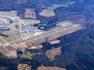
Atlanta Speedway Airport (formerly 4A7), is a public-use airport located three nautical miles (6 km) west of the central business district of Hampton, a city in Henry County, Georgia, United States. It was known as Clayton County Airport – Tara Field, which was the name still used by the Federal Aviation Administration (FAA) and the Georgia Department of Transportation (GDOT) until 2011. The airport was renamed Atlanta South Regional Airport, which was approved by the airport board of commissioners in December 2011, and was approved by the GDOT and the FAA before it went into effect. It was also known as Henry County Airport from 2013 to 2017.

Fort Worth Meacham International Airport is a general aviation airport located near the intersection of Interstate 820 and Business U.S. Highway 287 in Fort Worth, Texas, United States. It is named after former Fort Worth Mayor Henry C. Meacham. The airport covers 745 acres.

Addison Airport is a public airport in Addison, in Dallas County, Texas, United States, 9 mi north of downtown Dallas. It opened in 1954 and was purchased by the town of Addison in 1976. It is home to the Cavanaugh Flight Museum.

Sherman Municipal Airport is a city-owned public airport located 1 mile (1.6 km) mile southeast of the central business district of Sherman, in Grayson County, Texas.

Southern Wisconsin Regional Airport is a public airport located southwest of Janesville and north of Beloit in Rock County, Wisconsin, United States. Formerly known as Rock County Airport, it is owned and operated by the Rock County government. The airport has no scheduled commercial passenger service.

Camarillo Airport is a public airport located three miles (5 km) west of the central business district of Camarillo, a city in Ventura County, California, United States. The airport has one runway and serves privately operated general aviation and executive aircraft with no scheduled commercial service. A separate airfield in the southwest quadrant of the airport is for exclusive use of light-sport aircraft and ultralights. The airport is the site for an annual air show "Wings Over Camarillo", organized by the Southern California Wing of the Commemorative Air Force.

Arlington Municipal Airport is a public airport located three miles (5 km) southwest of the central business district of Arlington, a city in Snohomish County, Washington, United States. It is owned and operated by the City of Arlington.

Danbury Municipal Airport is a public use general aviation and commercial airport located three miles (5 km) southwest of the central business district of Danbury, in Fairfield County, Connecticut, United States. The airport opened in 1930. It is currently run by the City of Danbury under the management of Michael Safranek. It is included in the Federal Aviation Administration (FAA) National Plan of Integrated Airport Systems for 2017–2021, in which it is categorized as a regional reliever airport facility.

Chino Airport is a county-owned airport about three miles southeast of Chino, in San Bernardino County, California, United States. The Federal Aviation Administration's National Plan of Integrated Airport Systems for 2007–2011 classified it as a reliever airport, due to its proximity to the Ontario International Airport and the John Wayne Airport.
Iowa City Municipal Airport, is two miles southwest of downtown Iowa City, in Johnson County, Iowa. It is the oldest civil airport west of the Mississippi River still in its original location.
Bridgeport Municipal Airport is a public airport near Bridgeport, in Wise County, Texas. It is owned by the City of Bridgeport and is located 4 nautical miles (7.4 km) southwest of the central business district.

Treasure Coast International Airport is a public airport located three miles (5 km) northwest of the central business district of Fort Pierce, a city in St. Lucie County, Florida, United States. It is owned by the St. Lucie Board of County Commissioners.

Lebanon-Warren County Airport is a public airport located three miles (5 km) northwest of the central business district of Lebanon, on Greentree Road, in Warren County, Ohio, United States.

Conroe-North Houston Regional Airport is a public-use airport in Conroe, Texas, United States, 37 miles (60 km) north of the central business district of Houston. It is publicly owned by Montgomery County.
Fort Worth Spinks Airport is a city-owned, public-use airport located 14 nautical miles (26 km) south of the central business district of Fort Worth, in Tarrant County, Texas, United States. It is the newest of the three airports that are owned by the City of Fort Worth and it serves the cities of Fort Worth, Burleson, and Mansfield. The airport is located at the intersection of Interstate 35W and HWY 1187 and serves as a reliever airport for Fort Worth Meacham International Airport and Dallas–Fort Worth International Airport and has Class D designation.
Parker County Airport is a privately owned public airport in Hudson Oaks, Parker County, Texas, United States. The airport serves the city of Weatherford, and is located approximately 5 nautical miles (9.3 km) east of the central business district.
Horseshoe Bend Airport is a privately owned public airport in Weatherford, Parker County, Texas, United States, located approximately 12 nautical miles (22 km) southwest of the central business district. The airport has no IATA or ICAO designation.
