Bowling Green, Florida

Last updated

Bowling Green, Florida
Bowling green1.jpg
Bowling Green FL depot03.jpg
Bowling Green FL old hotel pano01.jpg
Hardee County Florida Incorporated and Unincorporated areas Bowling Green Highlighted.svg
Location in Hardee County and the state of Florida
Coordinates: 27°38′16″N81°49′32″W / 27.63778°N 81.82556°W / 27.63778; -81.82556
Country Flag of the United States.svg  United States
State Flag of Florida.svg  Florida
County   Hardee
Area
[1]
  Total1.26 sq mi (3.28 km2)
  Land1.26 sq mi (3.27 km2)
  Water0.00 sq mi (0.00 km2)
Elevation
118 ft (36 m)
Population
 (2020)
  Total2,405
  Density1,902.69/sq mi (734.90/km2)
Time zone UTC-5 (Eastern (EST))
  Summer (DST) UTC-4 (EDT)
ZIP code
33834
Area code 863
FIPS code 12-07775 [2]
GNIS feature ID0279294 [3]
Website City of Bowling Green, FL Website

Bowling Green is a city in Hardee County, Florida, United States. The population was 2,930 at the 2010 census.

Contents

Geography

Bowling Green is located at 27°38′16″N81°49′32″W / 27.637823°N 81.825609°W / 27.637823; -81.825609 . [4]

According to the United States Census Bureau, the city has a total area of 1.4 square miles (3.6 km2), all land.

History

One of the first settlers of the vicinity, A.M. Chester of Bowling Green, Kentucky, established a homestead in 1883. In 1886, he gave 40 acres to the Florida Southern Railway, a service that continues to operate in the area. As the town began to develop, the industries of Citrus Farming and Phosphate Mining took hold with in the town. [5]

Demographics

Historical population
CensusPop.Note
1910 422
1920 69264.0%
1930 1,02548.1%
1940 950−7.3%
1950 884−6.9%
1960 1,17132.5%
1970 1,35715.9%
1980 2,31070.2%
1990 1,836−20.5%
2000 2,75550.1%
2010 2,9306.4%
2020 2,405−17.9%
U.S. Decennial Census [6]

At the 2000 census, there were 2,892 people in 815 households, including 647 families, in the city. The population density was 2,042.0 inhabitants per square mile (788.4/km2). There were 933 housing units at an average density of 658.8 per square mile (254.4/km2). The racial makeup of the city was 57.05% White, 13.52% African American, 0.83% Native American, 0.35% Asian, 0.31% Pacific Islander, 26.00% from other races, and 1.94% from two or more races. Hispanic or Latino of any race were 46.06%. [2]

Of the 815 households, 41.3% had children under the age of 18 living with them, 54.5% were married couples living together, 18.3% had a female householder with no husband present, and 20.6% were non-families. 12.8% of households were one person and 7.1% were one person aged 65 or older. The average household size was 3.44 and the average family size was 3.68.

The age distribution was 33.1% under the age of 18, 12.2% from 18 to 24, 27.8% from 25 to 44, 16.0% from 45 to 64, and 10.9% 65 or older. The median age was 28 years. For every 100 females, there were 108.8 males. For every 100 females age 18 and over, there were 106.7 males.

The median household income was $28,209 and the median family income was $28,333. Males had a median income of $22,695 versus $17,125 for females. The per capita income for the city was $9,978. About 22.0% of families and 30.5% of the population were below the poverty line, including 33.5% of those under age 18 and 20.5% of those age 65 or over.

In 2010 Bowling Green had a population of 2,930. The racial and ethnic makeup of the population was 49.9% Mexican, 8.5% other Hispanic, 29.4% non-Hispanic white, 10.5% black or African American, 0.5% Native American, 0.5% Asian, and 2.3% two or more races. [7] The current Mayor of Bowling Green is Dr. N'kosi L. Jones.

Media

See also

Related Research Articles

<span class="mw-page-title-main">West Puente Valley, California</span> Census-designated place in California, United States

West Puente Valley is an unincorporated community and census-designated place in Los Angeles County, California, USA, northwest of La Puente. The population was 22,636 at the 2010 census, up from 22,589 at the 2000 census. The community is probably named for its location related to the city of La Puente.

<span class="mw-page-title-main">Neptune Beach, Florida</span> City in Florida, United States of America

Neptune Beach is a beachfront city east of Jacksonville in Duval County, Florida, United States. When the majority of Duval County communities consolidated with Jacksonville in 1968, Neptune Beach, along with Jacksonville Beach, Atlantic Beach and Baldwin remained quasi-independent. Like those other municipalities, it maintains its own municipal government but its residents vote in the Jacksonville mayoral election and are represented on the Jacksonville city council. As of the 2020 census, the population is 7,217. Neptune Beach is the smallest of the Jacksonville Beaches communities.

<span class="mw-page-title-main">Wauchula, Florida</span> City in Florida, United States of America

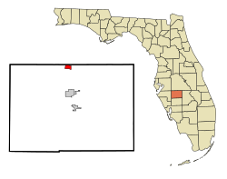
Wauchula is a city and the county seat of Hardee County, Florida, United States. As of the 2020 census, it had a population of 5,001.

<span class="mw-page-title-main">Mascotte, Florida</span> City in Florida

Mascotte is a city in Lake County, Florida, United States. As of the 2020 census, the population was 6,609, up from 5,101 in 2010. It is part of the Orlando–Kissimmee–Sanford Metropolitan Statistical Area.

<span class="mw-page-title-main">Minneola, Florida</span> City in Florida

Minneola is a city in Lake County, Florida, United States. It is part of the Orlando–Kissimmee–Sanford Metropolitan Statistical Area. The Minneola tangelo is named after the city. The population was 13,843 at the 2020 census.

<span class="mw-page-title-main">Tice, Florida</span> Census-designated place in Florida, United States

Tice is an unincorporated community and census-designated place (CDP) in Lee County, Florida, United States. As of the 2020 census, the CDP population was 4,853. It is part of the Cape Coral-Fort Myers, Florida Metropolitan Statistical Area.

<span class="mw-page-title-main">Belle Isle, Florida</span> City in Florida, United States

Belle Isle is a city in Orange County, Florida, United States. The population was 7,032 at the 2020 census. It is part of the Orlando–Kissimmee–Sanford Metropolitan Statistical Area.

<span class="mw-page-title-main">Edgewood, Florida</span> City in Florida, United States

Edgewood is a city in Orange County, Florida, United States. The population was 2,503 at the 2010 census. It is part of the Orlando–Kissimmee–Sanford Metropolitan Statistical Area.

<span class="mw-page-title-main">Meadow Woods, Florida</span> Census-designated place in Florida, United States

Meadow Woods is a census-designated place (CDP) and an unincorporated suburban development area located in southern Orange County, Florida, United States, between Orlando International Airport and Kissimmee. It is part of the Orlando–Kissimmee–Sanford, Florida Metropolitan Statistical Area. As of 2020, the population was 43,790.

<span class="mw-page-title-main">Oak Ridge, Florida</span> Census-designated place in Florida, United States

Oak Ridge is a census-designated place and unincorporated area in Orange County, Florida, United States. The population was 22,685 at the 2010 census. It is part of the Orlando–Kissimmee–Sanford, Florida Metropolitan Statistical Area.

<span class="mw-page-title-main">South Apopka, Florida</span> Census-designated place in Florida, United States

South Apopka is a census-designated place and an unincorporated area in Orange County, Florida, United States. Per the 2020 census, the population was 6,803. It is part of the Orlando–Kissimmee Metropolitan Statistical Area.

<span class="mw-page-title-main">Southchase, Florida</span> Census-designated place in Florida, United States

Southchase is a census-designated place and an unincorporated area in Orange County, Florida, United States. The population was 15,921 at the 2010 census. It is part of the Orlando–Kissimmee–Sanford, Florida Metropolitan Statistical Area.

<span class="mw-page-title-main">Lakeside Green, Florida</span> Unincorporated place in Florida, United States

Lakeside Green is a former census-designated place (CDP) and current unincorporated place in Palm Beach County, Florida, United States. The population was 3,311 at the 2000 census.

<span class="mw-page-title-main">South Pasadena, Florida</span> City in Florida, United States

South Pasadena is a city in southern Pinellas County, Florida, United States, near St. Pete Beach and Gulfport. The city is part of the Tampa–St. Petersburg–Clearwater metropolitan statistical area. The population was 5,353 at the 2020 census.

<span class="mw-page-title-main">East Palatka, Florida</span> CDP in Florida, United States

East Palatka is a census-designated place (CDP) in Putnam County, Florida, United States. It is located on the east side of the City of Palatka at the intersection of U.S. Route 17/State Road 20/State Road 100 and the southwestern terminus of State Road 207. The population was 1,654 at the 2010 census.

<span class="mw-page-title-main">Holly Hill, Florida</span> City in Florida, United States

Holly Hill is a city in Volusia County, Florida, United States. Holly Hill's city limits lie entirely on the Florida mainland, unlike the larger cities on either side of it, Daytona Beach and Ormond Beach, which encompass both the mainland and the beachfront barrier island across the Halifax River. The population was 12,958 at the 2020 census.

<span class="mw-page-title-main">South Daytona, Florida</span> City in Florida, United States

South Daytona is a city in Volusia County, Florida, United States. The population was 12,865 at the 2020 census.

<span class="mw-page-title-main">Smiths Grove, Kentucky</span> City in Kentucky, United States

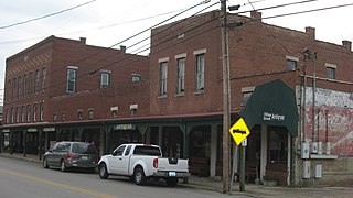
Smiths Grove is a home rule-class city in Warren County, Kentucky, United States. The population was 752 as of the 2020 Census. It is included in the Bowling Green, Kentucky Metropolitan Statistical Area.

<span class="mw-page-title-main">Woodburn, Kentucky</span> City in Kentucky, United States

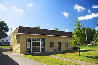
Woodburn is a home rule-class city in Warren County, Kentucky, United States. The population was 303 as of the 2020 Census. It is included in the Bowling Green, Kentucky Metropolitan Statistical Area.

<span class="mw-page-title-main">Bowling Green, Missouri</span> City in Missouri, United States

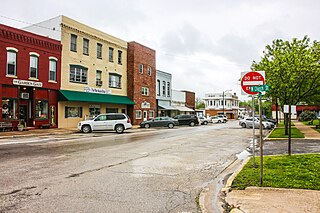
Bowling Green is a city and the county seat of in Pike County, Missouri, United States. The population was 5,334 at the 2010 census.

References

  1. "2020 U.S. Gazetteer Files". United States Census Bureau. Retrieved October 31, 2021.
  2. 1 2 "U.S. Census website". United States Census Bureau . Retrieved January 31, 2008.
  3. "US Board on Geographic Names". United States Geological Survey. October 25, 2007. Retrieved January 31, 2008.
  4. "US Gazetteer files: 2010, 2000, and 1990". United States Census Bureau. February 12, 2011. Retrieved April 23, 2011.
  5. "Bowling Green, Florida. Founded by Pioneers from Kentucky". Florida Back Roads Travel. Retrieved July 26, 2023.
  6. "Census of Population and Housing". Census.gov. Retrieved June 4, 2015.
  7. 2010 general demographic characteristics report for Bowling Green