Related Research Articles

Deschutes County is one of the 36 counties in the U.S. state of Oregon. As of the 2020 census, the population was 198,253. The county seat is Bend. The county was created in 1916 out of part of Crook County and was named for the Deschutes River, which itself was named by French-Canadian trappers of the early 19th century. It is the political and economic hub of Central Oregon. Deschutes comprises the Bend, Oregon Metropolitan Statistical Area. Deschutes is Oregon's fastest-growing and most recently formed county.

Newberry National Volcanic Monument was designated on November 5, 1990, to protect the area around the Newberry Volcano in the U.S. state of Oregon. The monument was created within the boundaries of the Deschutes National Forest, which is managed by the U.S. Forest Service, and includes 54,822 acres of lakes, lava flows, and geologic features in central Oregon.

The Deschutes River in central Oregon is a major tributary of the Columbia River. The river provides much of the drainage on the eastern side of the Cascade Range in Oregon, gathering many of the tributaries that descend from the drier, eastern flank of the mountains. The Deschutes provided an important route to and from the Columbia for Native Americans for thousands of years, and then in the 19th century for pioneers on the Oregon Trail. The river flows mostly through rugged and arid country, and its valley provides a cultural heart for central Oregon. Today the river supplies water for irrigation and is popular in the summer for whitewater rafting and fishing.

Newberry Volcano is a large active shield-shaped stratovolcano located about 20 miles (32 km) south of Bend, Oregon, United States, 35 miles (56 km) east of the major crest of the Cascade Range, within the Newberry National Volcanic Monument. Its highest point is Paulina Peak. The largest volcano in the Cascade Volcanic Arc, Newberry has an area of 1,200 square miles (3,100 km2) when its lava flows are taken into account. From north to south, the volcano has a length of 75 miles (121 km), with a width of 27 miles (43 km) and a total volume of approximately 120 cubic miles (500 km3). It was named for the geologist and surgeon John Strong Newberry, who explored central Oregon for the Pacific Railroad Surveys in 1855. The surrounding area has been inhabited by Native American populations for more than 10,000 years.

Belknap Crater is a shield volcano in the Cascade Range in the U.S. state of Oregon. Located in Linn County, it is associated with lava fields and numerous subfeatures including the Little Belknap and South Belknap volcanic cones. It lies north of McKenzie Pass and forms part of the Mount Washington Wilderness. Belknap is not forested and most of its lava flows are not vegetated, though there is some wildlife in the area around the volcano, as well as a number of tree molds formed by its eruptive activity.
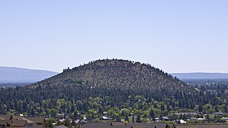
Pilot Butte is a lava dome that was created from an extinct volcano located in Bend, Oregon. It is a cinder cone butte which rises nearly 500 feet (150 m) above the surrounding plains. Bend is one of six cities in the United States to have a volcano within its boundaries. The other examples are Mount Tabor in Portland, Oregon, Jackson Volcano in Jackson, Mississippi, Diamond Head in Honolulu, Glassford Hill in Prescott Valley and Pilot Knob in Austin, Texas.

The Three Sisters are closely spaced volcanic peaks in the U.S. state of Oregon. They are part of the Cascade Volcanic Arc, a segment of the Cascade Range in western North America extending from southern British Columbia through Washington and Oregon to Northern California. Each more than 10,000 feet (3,000 m) in elevation, they are the third-, fourth- and fifth-highest peaks in Oregon. Located in the Three Sisters Wilderness at the boundary of Lane and Deschutes counties and the Willamette and Deschutes national forests, they are about 10 miles (16 km) south of the nearest town, Sisters. Diverse species of flora and fauna inhabit the area, which is subject to frequent snowfall, occasional rain, and extreme temperature variation between seasons. The mountains, particularly South Sister, are popular destinations for climbing and scrambling.
Lava Butte is a cinder cone in central Oregon, United States, just west of U.S. Route 97 between the towns of Bend, and Sunriver in Deschutes County. It is part of a system of small cinder cones on the northwest flank of Newberry Volcano, a massive shield volcano which rises to the southeast. The cinder cone is capped by a crater which extends about 60 feet (20 m) deep beneath its south rim, and 160 feet (50 m) deep from the 5,020-foot (1,530 m) summit on its north side. Lava Butte is part of the Newberry National Volcanic Monument.

Diamond Peak is a volcano in Klamath and Lane counties of central Oregon in the United States. It is a shield volcano, though it might also be considered a modest stratocone. Diamond Peak forms part of the Cascade Volcanic Arc, a segment of the Cascade Range in western North America extending from southern British Columbia through Oregon to Northern California. Reaching an elevation of 8,748 feet (2,666 m), the mountain is located near Willamette Pass in the Diamond Peak Wilderness within the Deschutes and Willamette national forests. Surrounded by coniferous forest and visible in the skyline from foothills near Eugene, Diamond Peak offers a few climbing routes and can be scrambled. Diamond Peak is one of Oregon's Matterhorns.

The Deschutes National Forest is a United States National Forest located in parts of Deschutes, Klamath, Lake, and Jefferson counties in central Oregon. It comprises 1.8 million acres (7,300 km2) along the east side of the Cascade Range. In 1908, the Deschutes National Forest was established from parts of the Blue Mountains, Cascade, and Fremont National Forests. In 1911, parts of the Deschutes National Forest were split off to form the Ochoco and Paulina National Forests, and parts of the Cascade and Oregon National Forests were added to the Deschutes. In 1915, the lands of the Paulina National Forest were rejoined to the Deschutes National Forest. A 1993 Forest Service study estimated that the extent of old growth in the forest was 348,100 acres (140,900 ha). Within the boundaries of the Deschutes National Forest is the Newberry National Volcanic Monument, containing cinder cones, lava flows, and lava tubes. The Deschutes National Forest as a whole contains in excess of 250 known caves. The forest also contains five wilderness areas, six National Wild and Scenic Rivers, the Oregon Cascade Recreation Area, and the Metolius Conservation Area. Forest headquarters are located in Bend, Oregon. There are local ranger district offices in Bend, Crescent, and Sisters.

Four Craters Lava Field is a basaltic volcanic field located south east of Newberry Caldera in the U.S. state of Oregon. The volcanic field covers about 30 square kilometers and post-dates Mount Mazama's eruption. Four Holocene cinder cones are the source of the flows in the field and are aligned along a fissure trending N 30° W. The cones rise 75 to 120 meters above the flows and the distance between the northernmost and southernmost cones is about 3.5 kilometers.

The Oregon Badlands Wilderness is a 29,301-acre (11,858 ha) wilderness area located east of Bend in Deschutes and Crook counties in the U.S. state of Oregon. The wilderness is managed by the Bureau of Land Management as part of the National Landscape Conservation System and was created by the Omnibus Public Land Management Act of 2009, which was signed into law by President Barack Obama on 30 March 2009.

The Horse Lava Tube System is a series of lava tubes within Deschutes County, Oregon, of the United States. The system starts within the Deschutes National Forest on the northern flank of Newberry Volcano and heads north into and near the city of Bend. The system continues north to Redmond and includes the Redmond Caves. The flow diverts into the Redmond Dry Canyon, where the last known segment is known to exist; however, the basalt flow that created the system goes beyond to Crooked River Ranch and terminates just short of the Crooked River Gorge. The lava flow that created the Horse system is also referred to as the Horse Cave lobe and it filled the ancient channel of the Deschutes River which at that time flowed around the east side of Pilot Butte. The Horse Cave lobe is a part of the basalt of Lava Top Butte which also consists of the Arnold Lava Tube System, the Badlands rootless shield, and the Lava Top butte basalt. All have a geologic age around 80,000 years old.
The Arnold Lava Tube System is series of lava tubes in Deschutes County, Oregon, in the United States. It is located several miles southeast of the city of Bend. The system starts in the Deschutes National Forest on the northern flank of Newberry Volcano, heads northeast onto BLM land before finally terminating on private property near Horse Ridge. The system acted as a conduit for the lavas from Lava Top Butte that later fed the Badlands rootless shield. The lava flow that created the Arnold system is also referred to as the basalt of Lava Top Butte and is related to the Horse Cave lobe which is a lava flow that created the Horse Lava Tube System. The lava flows of Lava Top Butte, the Badlands, the Horse system, and the Arnold system all have a geologic age around 80,000 years old.
The Paulina Mountains are a mountain range in Deschutes County, Oregon. There are 97 named mountains in the Paulina Mountains, the tallest and most famous one being Paulina Peak, which sits at 7,969 feet in elevation."Paulina Peak serves as the highest point of the Newberry Volcano, a large active stratovolcano that sits just 35 miles east of the crest of the Cascade Range. These summits are actually the remnants of an old crater called the Newberry Crater.

The Redmond Caves are a group of six lava tubes in Deschutes County, Oregon, United States. The caves are located in the city of Redmond and are jointly managed by the city and the Bureau of Land Management (BLM). Five of the caves are in the Redmond Caves Park and have been known locally for over 100 years. The caves are part of the Horse Lava Tube System and the farthest northern extent of the system. The lava flow that created both the Horse system and the Redmond Caves continued into the Redmond Dry Canyon and terminated near Crooked River Ranch. The caves have a geologic age of about 80,000 years.

Benham Falls are rapids of the Deschutes River located between Sunriver and Bend, Oregon, United States. With a pitch of 22.5°, they are rated Class 5 for watercraft, and are the largest falls on the upper Deschutes.

Skeleton Cave is a lava tube within Deschutes County, Oregon, of the United States. The cave is within Deschutes National Forest and is located on the northern flank of Newberry Volcano near the city of Bend. The cave is between 75,000 and 400,000 years old.
References
- ↑ "Boyd Cave Day Use Area". Fs.usda.gov. Retrieved 2017-12-24.
- ↑ Donnelly-Nolan, Julie M.; Stovall, Wendy K.; Ramsey, David W.; Ewert, John W.; Jensen, Robert A. (2011). James W. Hendley II (ed.). "USGS Fact Sheet 2011-3145: Newberry Volcano: Central Oregon's Sleeping Giant" (PDF). USGS.
- 1 2 Greeley, Ronald (1971). "Geology of Selected Lava Tubes in the Bend Area, Oregon, Bulletin 71" (PDF). Oregon State Dept. of Geology and Mineral Industries. Retrieved 2021-11-21.
- ↑ "Hike to Boyd Cave". theoutbound.com. Retrieved 2017-12-24.
- ↑ Purcell, David (1977), Guide to the Lava Tube Caves of Central Oregon, p. 53
- ↑ "Spelunking in Deschutes County teases out the primordial". bendbulletin.com. Retrieved 2017-12-24.
- ↑ "Lava caves show off Bend's dark side". blog.oregonlive.com. Retrieved 2017-12-24.
- 1 2 Skeels, Matt (2010), Undiscovered Country - 2010 NCA Regional Guidebook, p. 66
- ↑ Larson, Charles (1987). Central Oregon Caves. ABC Publishing. p. 44.
- ↑ Axon, Russ (2016). "The World Beneath Bend".