
Sevier County is a county of the U.S. state of Tennessee. As of the 2020 census, the population was 98,380. Its county seat and largest city is Sevierville. Sevier County comprises the Sevierville, TN Micropolitan Statistical Area, which is included in the Knoxville-Morristown-Sevierville, TN Combined Statistical Area.

Newport is a city in and the county seat of Cocke County, Tennessee, United States. The population was 6,945 at the 2010 census, down from 7,242 at the 2000 census. The estimated population in 2018 was 6,801. It is located along the Pigeon River.
Pittman Center is a town in Sevier County, Tennessee, United States. The population was 454 at the 2020 census and 502 at the 2010 census. The town borders Gatlinburg and the Great Smoky Mountains National Park. U.S. 321 passes through the town.
Sevierville is a city in and the county seat of Sevier County, Tennessee, United States, located in eastern Tennessee. The population was 17,889 at the 2020 United States Census.
The State of Franklin was an unrecognized proposed state located in what is today East Tennessee, United States. Franklin was created in 1784 from part of the territory west of the Appalachian Mountains that had been offered by North Carolina as a cession to Congress to help pay off debts related to the American War for Independence. It was founded with the intent of becoming the 14th state of the new United States.

The Territory South of the River Ohio, more commonly known as the Southwest Territory, was an organized incorporated territory of the United States that existed from May 26, 1790, until June 1, 1796, when it was admitted to the United States as the State of Tennessee. The Southwest Territory was created by the Southwest Ordinance from lands of the Washington District that had been ceded to the U.S. federal government by North Carolina. The territory's lone governor was William Blount.

John Sevier was an American soldier, frontiersman, and politician, and one of the founding fathers of the State of Tennessee. A member of the Democratic-Republican Party, he played a leading role in Tennessee's pre-statehood period, both militarily and politically, and he was elected the state's first governor in 1796. He served as a colonel of the Washington District Regiment in the Battle of Kings Mountain in 1780, and he commanded the frontier militia in dozens of battles against the Cherokee in the 1780s and 1790s.

James Robertson was an American explorer, soldier and Indian agent, and one of the founding fathers of what became the State of Tennessee. An early companion of explorer Daniel Boone, Robertson helped establish the Watauga Association in the early 1770s, and to defend Fort Watauga from an attack by Cherokee in 1776. In 1779, he co-founded what is now Nashville, and was instrumental in the settlement of Middle Tennessee. He served as a brigadier general in the Southwest Territory militia in the early 1790s, and as an Indian Commissioner in later life.

The Overmountain Men were American frontiersmen from west of the Blue Ridge Mountains which are the leading edge of the Appalachian Mountains, who took part in the American Revolutionary War. While they were present at multiple engagements in the war's southern campaign, they are best known for their role in the American victory at the Battle of Kings Mountain in 1780. The term "overmountain" arose because their settlements were west of, or "over", the Blue Ridge, which was the primary geographical boundary dividing several of the 13 American states from the Native American lands to the west. The Overmountain Men hailed from parts of Virginia, North Carolina, and what is now Tennessee and Kentucky.

The Watauga Association was a semi-autonomous government created in 1772 by frontier settlers living along the Watauga River in what is now Elizabethton, Tennessee. Although it lasted only a few years, the Watauga Association provided a basis for what later developed into the state of Tennessee and likely influenced other western frontier governments in the trans-Appalachian region. North Carolina annexed the Watauga settlement area, by then known as the Washington District, in November 1776. Within a year, the area was placed under a county government, becoming Washington County, North Carolina, in November 1777. This area covers the present day Washington County, Carter County, and other areas now located in the northeast part of the state of Tennessee.

The Sycamore Shoals of the Watauga River, usually shortened to Sycamore Shoals, is a rocky stretch of river rapids along the Watauga River in Elizabethton, Tennessee. Archeological excavations have found Native Americans lived near the shoals since prehistoric times, and Cherokees gathered there. As Europeans began settling the Trans-Appalachian frontier, the shoals proved strategic militarily, as well as shaped the economies of Tennessee and Kentucky. Today, the shoals are protected as a National Historic Landmark and are maintained as part of Sycamore Shoals State Historic Park.

The Cherokee–American wars, also known as the Chickamauga Wars, were a series of raids, campaigns, ambushes, minor skirmishes, and several full-scale frontier battles in the Old Southwest from 1776 to 1794 between the Cherokee and American settlers on the frontier. Most of the events took place in the Upper South region. While the fighting stretched across the entire period, there were extended periods with little or no action.

Fort Watauga, also known as Fort Caswell, was a fortification located in the Watauga River's Sycamore Shoals near modern-day Elizabethton, Tennessee. It was constructed from 1775 to 1776 by the Watauga Association, a semi-autonomous government founded by American settlers living near the river, to defend the settlers against attacks from British-allied Indians. The fort was originally named Fort Caswell after the governor of North Carolina, Richard Caswell.
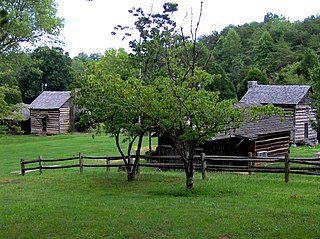
Marble Springs, also known as the Gov. John Sevier Home, is a state historic site in south Knox County, Tennessee, in the southeastern United States. The site was the home of John Sevier (1745–1815)—a Revolutionary War and frontier militia commander and later the first governor of Tennessee—from 1790 until his death in 1815. A cabin at the site was once believed to have been Sevier's cabin, although recent dendrochronological analyses place the cabin's construction date in the 1830s, well after Sevier had died.

Overhill Cherokee was the term for the Cherokee people located in their historic settlements in what is now the U.S. state of Tennessee in the Southeastern United States, on the western side of the Appalachian Mountains. This name was used by 18th-century European traders and explorers from British colonies along the Atlantic coast, as they had to cross the mountains to reach these settlements.
The Battle of Hightower in 1793 was part of the Cherokee–American wars, in which the Cherokee sought to defend tribal territory from increasing settlement by the citizens of the new United States. This particular battle took place at the Cherokee village of High Town (Itawayi), overlooking downtown Rome in present-day Floyd County, Georgia, resulting in the defeat of the Cherokee by a force led by John Sevier, future Governor of Tennessee.

Kodak is an unincorporated community and a neighborhood of Sevierville in Sevier County, Tennessee, United States. It is located along State Highway 139 and State Highway 66, and just south of I-40 and Knoxville, Tennessee. The elevation of Kodak is about 896 feet above sea level.
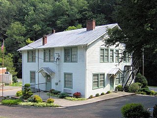
Wheatlands is an antebellum plantation in Sevier County, in the U.S. state of Tennessee. The plantation's surviving structures— which include the plantation house, a storage shed, and smokehouse— have been placed on the National Register of Historic Places. The plantation house has been called "the best example of a Federal-style building remaining in Sevier County."

The moon-eyed people are a legendary group of short, bearded white-skinned people who are said to have lived in Appalachia until the Cherokee expelled them. Stories about them, attributed to Cherokee tradition, are mentioned by early European settlers in America. In a 1797 book, Benjamin Smith Barton explains they are called "moon-eyed" because they saw poorly during the day. Some stories claim they created the area's pre-Columbian ruins, and they disappeared from the area. Barton cited as his source a conversation with Colonel Leonard Marbury, an early settler of Georgia. Marbury, a Revolutionary War officer and a Congressman in the Second Provincial Congress of Georgia (1775), acted as intermediary between Native American Indians in the state of Georgia and the United States government.
Samuel Wear was an American War of Independence soldier who fought at the Battle of Kings Mountain. He was one of the early inhabitants of, and a founder of, the "Lost State of Franklin". He later helped draft the Constitution of the State of Tennessee.


