Braden, Tennessee

Last updated

Braden, Tennessee
Fayette County Tennessee Incorporated and Unincorporated areas Braden Highlighted 4707840.svg
Location of Braden in Fayette County, Tennessee.
Coordinates: 35°22′30″N89°34′30″W / 35.37500°N 89.57500°W / 35.37500; -89.57500
Country United States
State Tennessee
County Fayette
Area
[1]
  Total3.67 sq mi (9.52 km2)
  Land3.67 sq mi (9.52 km2)
  Water0.00 sq mi (0.00 km2)
Elevation
315 ft (96 m)
Population
 (2020) [2]
  Total255
  Density69.39/sq mi (26.79/km2)
Time zone UTC-6 (Central (CST))
  Summer (DST) UTC-5 (CDT)
ZIP code
38010
Area code 901
FIPS code 47-07840 [3]
GNIS feature ID1305377 [4]

Braden is a town in Fayette County, Tennessee. The population was 282 at the 2010 census. The town is named after Joseph P. Braden. [5]

Contents

History

Braden was founded in 1850 as a depot on the Louisville and Nashville Railroad. [6]

Geography

Braden is located at 35°22′30″N89°34′30″W / 35.37500°N 89.57500°W / 35.37500; -89.57500 (35.374867, -89.574942). [7]

According to the United States Census Bureau, the town has a total area of 3.8 square miles (9.8 km2), all land.

Demographics

Historical population
CensusPop.Note
1880 77
1980 293
1990 35420.8%
2000 271−23.4%
2010 2824.1%
2020 255−9.6%
Sources: [8] [9] [2]

As of the census [3] of 2000, there were 271 people, 104 households, and 79 families residing in the town. The population density was 71.2 inhabitants per square mile (27.5/km2). There were 109 housing units at an average density of 28.6 per square mile (11.0/km2). The racial makeup of the town was 91.14% White, 7.01% Black or African American, 0.37% Native American, and 1.48% from two or more races. Hispanic or Latino of any race were 0.37% of the population.

There were 104 households, out of which 31.7% had children under the age of 18 living with them, 66.3% were married couples living together, 7.7% had a female householder with no husband present, and 24.0% were non-families. 16.3% of all households were made up of individuals, and 4.8% had someone living alone who was 65 years of age or older. The average household size was 2.61 and the average family size was 2.97.

In the town, the population was spread out, with 22.5% under the age of 18, 7.7% from 18 to 24, 33.9% from 25 to 44, 28.0% from 45 to 64, and 7.7% who were 65 years of age or older. The median age was 37 years. For every 100 females, there were 103.8 males. For every 100 females age 18 and over, there were 103.9 males.

The median income for a household in the town was $48,333, and the median income for a family was $51,750. Males had a median income of $35,625 versus $30,000 for females. The per capita income for the town was $19,610. About 4.9% of families and 7.0% of the population were below the poverty line, including 10.3% of those under the age of eighteen and none of those 65 or over.

Related Research Articles

<span class="mw-page-title-main">Fayette County, Tennessee</span> County in Tennessee, United States

Fayette County is a county located in the U.S. state of Tennessee. As of the 2020 census, the population was 41,990. Its county seat is Somerville. The county was named after the Marquis de la Fayette, French hero of the American Revolution. A part of the Memphis, TN-MS-AR Metropolitan Statistical Area, Fayette County is culturally alike to the Mississippi Delta and was a major area of cotton plantations dependent on slave labor in the nineteenth century.

<span class="mw-page-title-main">Vina, Alabama</span> Town in Alabama, United States

Vina is a town in Franklin County, Alabama, United States. At the 2010 census the population was 358, down from 400 in 2000.

<span class="mw-page-title-main">Point MacKenzie, Alaska</span> CDP in Alaska, United States

Point MacKenzie is a census-designated place (CDP) in Matanuska-Susitna Borough, Alaska, United States. It is part of the Anchorage, Alaska Metropolitan Statistical Area. At the 2020 census the population was 1,852, up from 529 in 2010.

<span class="mw-page-title-main">Pine Castle, Florida</span> Census-designated place in Florida, United States

Pine Castle is a census-designated place and unincorporated area in Orange County, Florida, United States. It is part of the Orlando–Kissimmee–Sanford, Florida Metropolitan Statistical Area.

<span class="mw-page-title-main">Culdesac, Idaho</span> City in Idaho, United States

Culdesac is a city in Nez Perce County, Idaho, United States. The population was 380 at the 2010 census. It is part of the Lewiston, ID-WA Metropolitan Statistical Area.

<span class="mw-page-title-main">Cedarville, Illinois</span> Village in Illinois, United States

Cedarville is a village in Stephenson County, Illinois, United States. The population was 741 at the 2010 census, up from 719 in 2000. It is the birthplace of social activist Jane Addams, the 1931 Nobel Peace Prize winner.

<span class="mw-page-title-main">Carrsville, Kentucky</span> City in Kentucky, United States

Carrsville is a home rule-class city beside the Ohio River in Livingston County, Kentucky, in the United States. The population was 50 at the 2010 census, declining from 64 as of 2000. It is part of the Paducah, KY-IL Metropolitan Statistical Area. It is situated just west of the junction of where Buck Creek empties into the Ohio River.

<span class="mw-page-title-main">Fayette, Maine</span> Town in the state of Maine, United States

Fayette is a town in Kennebec County, Maine, United States. The population was 1,160 as of the 2020 census. A popular recreation spot in central Maine, Fayette is part of the Winthrop Lakes Region.

<span class="mw-page-title-main">Herald Harbor, Maryland</span> Census-designated place in Maryland, United States

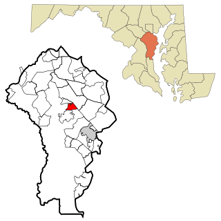
Herald Harbor is a census-designated place and an unincorporated community in Anne Arundel County, Maryland, United States. As of the 2010 census, the population was 2,603. It is a quiet residential area with a scenic view of the Severn River and is near the community of Crownsville and Interstate 97. Herald Harbor is known for its area immediately along the Severn River known as Long Point on the Severn, a fairly affluent neighborhood composed mainly of retired and wealthy land owners.

<span class="mw-page-title-main">Cedar Creek Township, Wexford County, Michigan</span> Civil township in Michigan, United States

Cedar Creek Township is a civil township of Wexford County in the U.S. state of Michigan. The population was 1,855 at the 2020 census.

<span class="mw-page-title-main">Connellsville Township, Pennsylvania</span> Township in Pennsylvania, United States

Connellsville Township is a township in Fayette County, Pennsylvania, United States. The population was 2,073 at the 2020 census, a decline from the figure of 2,391 tabulated in 2010.

<span class="mw-page-title-main">Jefferson Township, Greene County, Pennsylvania</span> Township in Pennsylvania, United States

Jefferson Township is a township that is located in Greene County, Pennsylvania, United States. The population was 2,352 at the time of the 2020 census, even with the 2,352 at the 2010 census.

<span class="mw-page-title-main">Butler Township, Schuylkill County, Pennsylvania</span> Township in Pennsylvania, United States

Butler Township is a township in Schuylkill County, Pennsylvania, United States. Formed in 1848 from part of Barry Township, it is named for war hero William Orlando Butler.

<span class="mw-page-title-main">Gallaway, Tennessee</span> City in Tennessee, United States

Gallaway is a city in Fayette County, Tennessee, United States. The population was 680 at the 2010 census.

<span class="mw-page-title-main">La Grange, Tennessee</span> Town in Tennessee, United States

La Grange is a town in Fayette County, Tennessee, United States. The population was 133 at the 2010 census. A large area in the town is listed on the National Register of Historic Places as La Grange Historic District.

<span class="mw-page-title-main">Moscow, Tennessee</span> City in Tennessee, United States

Moscow is a city in Fayette County, Tennessee, United States. The population was 568 at the 2020 census, 556 at the 2010 census, and 422 at the 2000 census. The town was named after a Cherokee Chief [Mosgo], meaning "Town between 2 rivers." North Fork and Wolf Rivers.

<span class="mw-page-title-main">Somerville, Tennessee</span> Town in Tennessee, United States

Somerville is a town in Fayette County, Tennessee, United States. It is part of the Memphis metropolitan area. The population was 3,415 at the 2020 census, up from 3,094 at the 2010 census. It is the county seat of Fayette County.

<span class="mw-page-title-main">Williston, Tennessee</span> City in Tennessee, United States

Williston is a city in Fayette County, Tennessee, United States. The population was 395 at the 2010 census.

<span class="mw-page-title-main">Fayetteville, Texas</span> City in Texas, United States

Fayetteville is a city in Fayette County, Texas, United States. The population was 246 at the 2020 census.

<span class="mw-page-title-main">Lumberport, West Virginia</span> Town in West Virginia, United States

Lumberport is a town in Harrison County, located in northern West Virginia, United States. The population was 720 at the 2020 census.

References

  1. "ArcGIS REST Services Directory". United States Census Bureau. Retrieved October 15, 2022.
  2. 1 2 "Census Population API". United States Census Bureau. Retrieved October 15, 2022.
  3. 1 2 "U.S. Census website". United States Census Bureau . Retrieved January 31, 2008.
  4. "US Board on Geographic Names". United States Geological Survey. October 25, 2007. Retrieved January 31, 2008.
  5. Larry Miller, Tennessee Place Names (Indiana University Press, 2001), p. 28
  6. "City of Braden". Fayette County Chamber of Commerce. Archived from the original on February 4, 2014. Retrieved January 29, 2014.
  7. "US Gazetteer files: 2010, 2000, and 1990". United States Census Bureau. February 12, 2011. Retrieved April 23, 2011.
  8. "Census of Population and Housing: Decennial Censuses". United States Census Bureau . Retrieved March 4, 2012.
  9. "Incorporated Places and Minor Civil Divisions Datasets: Subcounty Resident Population Estimates: April 1, 2010 to July 1, 2012". Population Estimates. U.S. Census Bureau. Archived from the original on June 11, 2013. Retrieved December 11, 2013.

35°22′30″N89°34′30″W / 35.374867°N 89.574942°W / 35.374867; -89.574942