Bradley, Arkansas | |
---|---|
Coordinates: 33°05′58″N93°39′25″W / 33.09944°N 93.65694°W | |
Country | United States |
State | Arkansas |
County | Lafayette |
Area | |
• Total | 0.91 sq mi (2.36 km2) |
• Land | 0.91 sq mi (2.36 km2) |
• Water | 0.00 sq mi (0.00 km2) |
Elevation | 259 ft (79 m) |
Population (2020) | |
• Total | 405 |
• Density | 443.59/sq mi (171.30/km2) |
Time zone | UTC−06:00 (Central (CST)) |
• Summer (DST) | UTC−05:00 (CDT) |
ZIP Code | 71826 |
Area code | 870 |
FIPS code | 05-08290 |
GNIS feature ID | 2403911 [2] |
Bradley is a city in Lafayette County, Arkansas, United States. The population was 628 at the 2010 census. [3]
Bradley is located in southern Lafayette County. It sits at the intersection of Arkansas Highways 29 and 160. Highway 29 leads north 19 miles (31 km) to Lewisville and south 6 miles (10 km) to the Louisiana border at Arkana. Plain Dealing, Louisiana, is 14 miles (23 km) south of Bradley. Highway 160 leads east from Bradley 7 miles (11 km) to the community of State Line and west 15 miles (24 km) to Interstate 49 near Doddridge.
According to the United States Census Bureau, Bradley has a total area of 0.93 square miles (2.4 km2), all land. [3]
Census | Pop. | Note | %± |
---|---|---|---|
1910 | 123 | — | |
1920 | 290 | 135.8% | |
1930 | 363 | 25.2% | |
1940 | 409 | 12.7% | |
1950 | 444 | 8.6% | |
1960 | 712 | 60.4% | |
1970 | 706 | −0.8% | |
1980 | 790 | 11.9% | |
1990 | 585 | −25.9% | |
2000 | 563 | −3.8% | |
2010 | 628 | 11.5% | |
2020 | 405 | −35.5% | |
U.S. Decennial Census [4] |
Race / Ethnicity (NH = Non-Hispanic) | Pop 2000 [5] | Pop 2010 [6] | Pop 2020 [7] | % 2000 | % 2010 | % 2020 |
---|---|---|---|---|---|---|
White alone (NH) | 261 | 263 | 165 | 46.36% | 41.88% | 40.74% |
Black or African American alone (NH) | 291 | 353 | 222 | 51.69% | 56.21% | 54.81% |
Native American or Alaska Native alone (NH) | 0 | 1 | 0 | 0.00% | 0.16% | 0.00% |
Asian alone (NH) | 2 | 1 | 1 | 0.36% | 0.16% | 0.25% |
Pacific Islander alone (NH) | 0 | 0 | 0 | 0.00% | 0.00% | 0.00% |
Some Other Race alone (NH) | 0 | 0 | 0 | 0.00% | 0.00% | 0.00% |
Mixed Race or Multi-Racial (NH) | 5 | 1 | 8 | 0.89% | 0.16% | 1.98% |
Hispanic or Latino (any race) | 4 | 9 | 9 | 0.71% | 1.43% | 2.22% |
Total | 563 | 628 | 405 | 100.00% | 100.00% | 100.00% |
As of the census [8] of 2000, there were 563 people, 223 households, and 134 families residing in the city. The population density was 614.8 inhabitants per square mile (237.4/km2). There were 285 housing units at an average density of 311.2 per square mile (120.2/km2). The racial makeup of the city was 46.36% White, 52.40% Black or African American, 0.36% Asian, and 0.89% from two or more races. 0.71% of the population were Hispanic or Latino of any race.
There were 223 households, out of which 30.0% had children under the age of 18 living with them, 32.7% were married couples living together, 22.4% had a female householder with no husband present, and 39.9% were non-families. 37.2% of all households were made up of individuals, and 20.6% had someone living alone who was 65 years of age or older. The average household size was 2.52 and the average family size was 3.38.
In the city, the population was spread out, with 33.6% under the age of 18, 9.6% from 18 to 24, 23.1% from 25 to 44, 17.9% from 45 to 64, and 15.8% who were 65 years of age or older. The median age was 31 years. For every 100 females, there were 80.4 males. For every 100 females age 18 and over, there were 70.8 males.
The median income for a household in the city was $14,375, and the median income for a family was $19,306. Males had a median income of $21,719 versus $14,688 for females. The per capita income for the city was $2,455. About 43.9% of families and 49.6% of the population were below the poverty line, including 66.5% of those under age 18 and 42.2% of those age 65 or over.
Public education for elementary and secondary students is provided by the Emerson-Taylor-Bradley School District, which includes Bradley Elementary School and Bradley High School. The school's mascot and athletic emblem is the Bear, with purple and gold serving as the school colors.
The former Bradley School District consolidated into the Emerson-Taylor district effective July 1, 2013. [9]
Lafayette County is a county located in the U.S. state of Arkansas. As of the 2020 census, the population was 6,308, making it the third-least populous county in Arkansas. The county seat is Lewisville. Lafayette County was formed on October 15, 1827, and named in honor of the Marquis de Lafayette, a French military hero of the American Revolutionary War. It is a dry county; therefore, the sale of alcohol is prohibited.
Columbia County is a county located in the U.S. state of Arkansas. As of the 2020 census, the population was 22,801. The county seat is Magnolia. The county was formed on December 17, 1852, and was named for Christopher Columbus. The Magnolia, AR Micropolitan Statistical Area includes all of Columbia County.
Harrell is a town in Calhoun County, Arkansas, United States. The population was 254 at the 2010 census. It is part of the Camden Micropolitan Statistical Area.
Emerson is a town in Columbia County, Arkansas, United States. The population was 368 at the 2010 census.
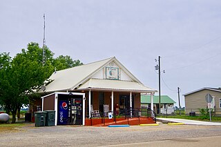
Taylor is a city in Columbia County, Arkansas, United States. The population was 566 at the 2010 census.
Anthonyville is a town in Crittenden County, Arkansas, United States. The population was 161 at the 2010 census, down from 250 in 2000.
Edmondson is a town in Crittenden County, Arkansas, United States. The population was 427 at the 2010 census.
Turrell is a city in Crittenden County, Arkansas, United States. Per the 2020 census, the population was 517.
Carthage is a town in Dallas County, Arkansas, United States. The population was 343 at the 2010 census.
Washington is a city in Ozan Township, Hempstead County, Arkansas, United States. The population was 180 at the 2010 census, up from 148 in 2000. It is part of the Hope Micropolitan Statistical Area. The city is home to Historic Washington State Park.
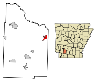
Lewisville is a city in Lafayette County, Arkansas, United States. The population was 1,280 at the 2010 census. It is the county seat of Lafayette County.
Stamps is a city in Lafayette County, Arkansas, United States. The population was 1,693 at the 2010 census, down from 2,131 at the 2000 census.
Summit is a city in Marion County, Arkansas, United States. The population was 544 at the 2020 census, down from 604 in 2010.
Garland, also known as Garland City, is a town in Miller County, Arkansas, United States. It is part of the Texarkana, Texas - Texarkana, Arkansas Metropolitan Statistical Area. The population was 195 at the 2020 census, down from 242 in 2010.
Dell is a town in Mississippi County, Arkansas, United States. The population was 194 at the 2020 census.
Etowah is a town in Mississippi County, Arkansas, United States. The population was 254 at the 2020 census, down from 351 in 2010.
Bluff City is an unincorporated town in Nevada County, Arkansas, United States. The population was 158 at the 2000 census. It is part of the Hope Micropolitan Statistical Area.
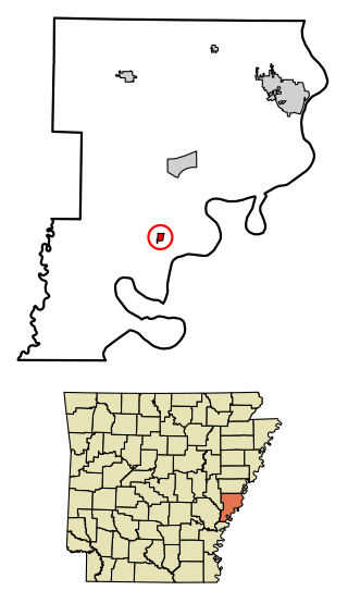
Elaine is a small town in Phillips County, Arkansas, United States, in the Arkansas Delta region of the Mississippi River. The population was 636 at the 2010 census.
Freeport is a city in Walton County, Florida, United States. It is part of the Crestview–Fort Walton Beach–Destin metropolitan area. As of the 2020, the population recorded by the U.S. Census Bureau was 5,861. Freeport is one of the fastest growing cities in Florida. After the construction of the massive group of neighborhoods, Hammock Bay, the population exploded.
Lula is a town in Coahoma County, Mississippi, United States. Per the 2020 census, the population was 204.