Brantford and Hamilton Electric Railway

Last updated
Brantford and Hamilton Electric Railway
B&H interurban in Ancaster, 1907-8.jpg
In the earliest known photograph of the B&H in operation, an interurban car is seen at Ancaster during the winter of 1907-8.
Overview
Parent companyDominion Power and Transmission Company
Headquarters Hamilton, Ontario
Reporting mark B&H
Locale Southern Ontario
Dates of operationDecember 21, 1907 (1907-12-21Tdf) to AncasterJune 30, 1931 (1931-06-30Tdf)
Technical
Track gauge 4 ft 8+12 in (1,435 mm) standard gauge
Electrification 600 V overhead
Route map

Contents

BSicon exKBHFa.svg
Hamilton Terminal Station
BSicon exHST.svg
Hamilton James Street
BSicon exCONTgq.svg
BSicon exKRZ.svg
BSicon exCONTfq.svg
BSicon exHST.svg
Hamilton Garth Street
BSicon numN300.svg
BSicon exSTR.svg
BSicon exELC-PT.svg
Ancaster electrical substation
BSicon exHST.svg
Ancaster
BSicon exHST.svg
Alberton
BSicon exHST.svg
Langford
BSicon exHST.svg
Cainsville
BSicon exHST.svg
Brantford Mohawk Park
BSicon exSTR.svg
BSicon exELC-PT.svg
Brantford Murray Street electrical substation
BSicon exHST.svg
Brantford Alfred Street
B&H freight station
BSicon exCONTgq.svg
BSicon exKRZ.svg
BSicon exCONTfq.svg
BSicon exBST.svg
Brantford Market Street
terminus 1908–1916
BSicon exSTR.svg
BSicon exCONTgq.svg
BSicon exKBHFe.svg
BSicon exSTRq.svg
BSicon exCONTfq.svg
Brantford LE&N station
Lake Erie and Northern Railway

The Brantford and Hamilton Electric Railway (B&H) was an interurban electric railway which operated between Hamilton and Brantford in Ontario, Canada. According to Hilton & Due, this was the last radial (interurban) railway constructed in the Hamilton area and the only one built to a high standard. [1]

Route and operations

By the end of 1916, the Brantford and Hamilton Electric Railway line was at its maximum length. From Hamilton Terminal at Catherine Street, the line went east along Main Street and south on Hess Street to Aberdeen Avenue where it left the street to run southwest to the foot of Hamilton Mountain near present-day Dundurn Street South. It then climbed the escarpment on a 2.5 percent grade, [2] that was 11 kilometres (7 mi) long and elevated the line by 150 metres (500 ft). Halfway up the escarpment, there was a station to serve a golf club and a sanitarium. [3] The line reached the top of the escarpment near present-day Scenic Drive. The B&H passed through the communities of Ancaster, Alberton, Langford, and Cainsville. [2] It entered Brantford on a private right-of-way running along Glenwood Drive paralleling a derelict canal. It terminated at the Lake Erie and Northern (LE&N) station at Lorne Bridge. [2] [3]

The LE&N, an interurban that ran between Port Dover and Galt, shared its station in Brantford with the B&H. Since LE&N used 1500 volts and the B&H 600 volts, two overhead wires were used at the station, and B&H crews had to be careful to select the correct wire. To avoid this problem, B&H cars were often parked outside of the station structure, which was a two-storey building with a single track passing through it on the ground floor. [3] Except for the station area, B&H cars could not run on the LE&N rails because of the voltage difference. [2]

After 1917, the LE&N had an interchange with the Grand Trunk Railway's (GTR) Tillsonburg line, which it accessed via the B&H to the east of the LE&N station. There was a small yard south of Wharfe Street for freight cars. To protect nearby B&H cars from electrical damage, there was also a storage track to park B&H cars while the LE&N was switching freight cars. The overhead wires in the shared area were isolated so they could be switched as needed between 1500 volts for LE&N or 600 volts for the B&H. [2]

According to a B&H timetable, the service frequency was hourly with service from Hamilton starting at 6:30 am (8:20 am on Sundays) to 11:20 pm (10:20 pm on Sundays). A trip over the 37-kilometre (23 mi) line was scheduled to take 65 minutes. B&H customers could purchase interline tickets which allowed them to transfer to the LE&N in Brantford using a single ticket. Freight traffic included express, mail and milk which could be carried on box motors. [3]

History

On July 18, 1904, the Brantford and Hamilton Electric Railway was incorporated by federal charter. [2] A token amount of construction was performed in 1905 to meet legal obligations. Grading for the line began on July 27, 1906. During construction, the original backers of the line ran into financial difficulties, and ownership of the line passed to the Dominion Power and Transmission Company in 1907. [3]

Six cars were ordered from J. G. Brill Company which had a designed speed of 80 kilometres per hour (50 mph). [3] The first cars arrived in June 1907; test runs started June 16. [2]

The line was opened to Ancaster on December 21, 1907 and to Alfred Street in Brantford on May 23, 1908. After building a crossing with the Tillsonburg branch of the Grand Truck Railway (GTR), the line was extended to Market Street on November 3, 1908. After the interurban Lake Erie and Northern Railway (LE&N) constructed its line into Brantford, the B&H extended its line to Lorne Bridge on December 16, 1916 in order to share the LE&N station there, which the LE&N opened on March 12, 1917. [3]

In 1917, the Board of Railway Commissioners ordered the LE&N and the GTR to interhange freight in Brantford. Since there was no suitable location along the LE&N line, the interchange was built on the B&H with the provision to switch the overhead wire between the LE&N's 1500 volts and the B&H's 600 volts. After a few months, a separate siding was built for B&H cars to lay over while the LE&N switched freight cars. [3]

Circa 1921, the B&H set up a freight station at Alfred Street in Brantford. It used the body of a box car with the platform being a flat car. [3]

On October 18, 1925, the B&H was interlined with the Hamilton Radial Electric Railway (HRER) so that trains ran from Burlington through to Brantford. This arrangement came to an end on January 5, 1929, when the HRER was replaced by buses. Also on that date, buses alternated with interurban cars to service the route between Hamilton and Brantford. [3]

Dominion Power wished to sell its bus operations, but a condition of sale was that the remaining Hamilton radial lines be shut down. Thus, the final day of operation for the B&H was June 30, 1931. On February 2, 1932, an interurban car made one additional non-revenue run to collect portable equipment from substations along the line. The LE&N took over joint trackage from the B&H in Brantford. [3] After much of the B&H's track was removed in 1932, the B&H discovered it left a freight motor stranded at Trinity; it had to be trucked to the scapyard. [2]

The LE&N purchased the section of the B&H line it used from the LE&N station to just west of Lynwood Drive in order to serve several industries in the area as well as to maintain the interchange with Canadian National Railway (formerly the GTR). The former B&H tracks stayed in service until 1972. [2]

Postscript

Much of the route of the Brantford-Hamilton Electric Railway from Dundas ran parallel to the present-day Highway 403, also known as the Chedoke Expressway. The section east of Highway 403 is now operated by the City of Hamilton as the Chedoke Radial Trail, a 2.7-kilometre (1.7 mi) pedestrian and bicycle pathway. The trail includes the grade up the escarpment where there is a cut leaving a stone face on either side. [4] The path of the former railway track is lost at the Highway 403 interchange at Mohawk Road, but can be picked up again as the Radial Right of Way Ancaster at the west end of Hiawatha Boulevard. The trail terminates at Wilson Street in the former municipality of Ancaster. [5]

See also

Related Research Articles

<span class="mw-page-title-main">Ancaster, Ontario</span> Community/former town in Ontario, Canada

Ancaster is a historic town in the city of Hamilton, Ontario, Canada, located on the Niagara Escarpment. Founded as a town in 1793, it immediately developed itself into one of the first significant and influential early British Upper Canada communities established during the late 18th century eventually amalgamating with the city of Hamilton in 2001. By 1823, due to its accessible waterpower and location at the juncture of prehistoric indigenous trading routes, Ancaster had become Upper Canada's largest industrial and commercial centre. Additionally, Ancaster had at that time attracted the 2nd largest populace (1,681) in Upper Canada, trailing only Kingston, but surpassing the populations of nearby Toronto (1,376) and Hamilton (1,000). After this initial period of prosperity in the late 18th century, sudden significant water and rail transportation advancements of the early 19th century would soon better benefit Ancaster's neighbouring towns nearer the Lake Ontario waterfront. Stationary steam engines for industries rapidly developing in the 19th century would eventually make Ancaster's water-powered industries less vital. As a result, after the 1820s, Ancaster's influence would begin to wane during the remainder of the 19th century.

<span class="mw-page-title-main">Cincinnati and Lake Erie Railroad</span> Interurban railway in Ohio, US

The Cincinnati and Lake Erie Railroad (C&LE) was a short-lived electric interurban railway that operated in 1930–1939 Depression-era Ohio and ran between the major cities of Cincinnati, Dayton, Springfield, Columbus, and Toledo. It had a substantial freight business and interchanged with other interurbans to serve Detroit and Cleveland. Its twenty high-speed "Red Devil" interurban passenger cars operated daily between Cincinnati and Cleveland via Toledo, the longest same equipment run by an interurban in the United States. The C&LE failed because of the weak economy and the loss of essential freight interchange partners. It ceased operating in 1939.

King's Highway 403, or simply Highway 403, is a 400-series highway in the Canadian province of Ontario that travels between Woodstock and Mississauga, branching off from and reuniting with Highway 401 at both ends and travelling south of it through Hamilton and Mississauga. It is concurrent with the Queen Elizabeth Way (QEW) for 22 km (14 mi) from Burlington to Oakville. The Highway 403 designation was first applied in 1963 to a short stub of freeway branching off the QEW, and the entire route was completed on August 15, 1997, when the section from Brantford to the then-still independent Town of Ancaster was opened to traffic. The section of Highway 403 between Woodstock and Burlington was formally dedicated as the Alexander Graham Bell Parkway on April 27, 2016, in honour of Alexander Graham Bell.

The Toronto Suburban Railway was a Canadian electric railway operator with local routes in west Toronto, and a radial (interurban) route to Guelph.

<span class="mw-page-title-main">Metropolitan line (Toronto)</span> Toronto railway electric radial line

The Metropolitan line in the Toronto area, operated by the Metropolitan Street Railway, started out as a local horsecar line and transformed itself into an electric radial line extending to Lake Simcoe, following an old stage coach route. In 1904, the railway was acquired by the Toronto and York Radial Railway (T&YRR) and became the T&YRR Metropolitan Division. In 1922, the City of Toronto acquired the T&YRR and contracted Ontario Hydro to manage the four T&YRR lines including the Metropolitan. In 1927, the TTC took over the operation of the Metropolitan Line to Sutton, and renamed it the Lake Simcoe line. In 1930, the TTC closed the Metropolitan Line but shortly reopened the portion between Glen Echo and Richmond Hill operating it as the North Yonge Railways until 1948.

<span class="mw-page-title-main">North Yonge Railways</span>

The North Yonge Railways was a radial railway line operated by the Toronto Transportation Commission from 1930 to 1948 between Glen Echo (Toronto) and Richmond Hill. The line was created by reopening the southern portion of the TTC's Lake Simcoe radial line that had closed in 1930.

<span class="mw-page-title-main">Toronto, Hamilton and Buffalo Railway</span> Former railway in Canada

The Toronto, Hamilton and Buffalo Railway was a railway based in Hamilton that ran in Southern Ontario from 1892 to 1987. It never reached the other two cities in its name although it had branch lines extending to Dunnville and Port Maitland.

The Cincinnati, Hamilton and Dayton Railway (CH&DR) was an electric interurban railway that existed between 1926 and 1930 in the U.S. state of Ohio. It was absorbed in 1930 into the new Cincinnati and Lake Erie interurban railway. In typical interurban fashion, it had its own right of way in open country, although this was often adjacent or parallel to a road. In cities and towns it operated on city streets. This included two and three car freight/express trains as well as passenger cars.

<span class="mw-page-title-main">Grand River Railway</span> Former interurban railway in Waterloo Region, Ontario, Canada

The Grand River Railway was an interurban electric railway in what is now the Regional Municipality of Waterloo, in Southwestern Ontario, Canada.

The Hamilton and Dundas Street Railway was an interurban railway operator which ran between Hamilton and Dundas in Southern Ontario, Canada.

The Hamilton, Grimsby and Beamsville Electric Railway (HG&B) was an interurban railway that operated between Hamilton and Vineland in the Niagara Peninsula in Ontario, Canada. It was incorporated in 1894.

The Hamilton–Brantford–Cambridge Trails are a network of multiuse interurban recreational rail trails connecting several municipalities in southern Ontario, Canada. The trails are part of the Southern Ontario Loop of the Trans Canada Trail. From end to end, the trail is 80 kilometres (50 mi) long, running from Cambridge south through Paris to Brantford and then East to central Hamilton.

<span class="mw-page-title-main">Dundas Valley Conservation Area</span> Conservation area in Ontario, Canada

Dundas Valley Conservation Area is located on the Niagara Escarpment in Dundas, Ontario, a constituent community of Hamilton, Ontario, and is owned and operated by the Hamilton Conservation Authority. Its 40-kilometre trail system provides a connection to the Bruce Trail. The area contains a trailhead of the Hamilton-Brantford-Cambridge Trails, Canada's first fully developed interurban multi-use trail system, which is a part of the Trans Canada Trail.

<span class="mw-page-title-main">Schomberg and Aurora Railway</span>

The Schomberg and Aurora Railway was a 36 km long railway in Ontario, Canada, running from the town of Schomberg to Oak Ridges, just south of Aurora. It connected Schomberg to the Metropolitan Line of the Toronto and York Radial Railway (T&YRR) tram service running along Yonge Street, and from there into the Toronto city proper. The service ran for 25 years between 1902 and 1927; the rails were pulled up shortly thereafter.

Ainslie Wood is a residential neighbourhood in Hamilton, Ontario, Canada. It is centered on Alexander Park and located near McMaster University. It is bordered to the north by Main Street, Cootes Drive and Dundas, to the south and east by Highway 403, and to the west by Dundas and Ancaster.

<span class="mw-page-title-main">Lake Erie and Northern Railway</span> Former interurban railway in Ontario, Canada

The Lake Erie and Northern Railway was an interurban electric railway which operated in the Grand River Valley in Ontario, Canada. The railway owned and operated a north–south mainline which ran from Galt in the north to Port Dover on the shore of Lake Erie in the south. Along the way, it ran through rural areas of Waterloo County, Brant County, and Norfolk County, as well as the city of Brantford, where it had an interchange with the Brantford and Hamilton Electric Railway. Construction on the mainline began in 1913. The railway began operations in 1916 as a subsidiary of the Canadian Pacific Railway (CPR), which had purchased the line before construction had finished. In 1931, it was consolidated with the Grand River Railway under a single CPR subsidiary, the Canadian Pacific Electric Lines (CPEL), which managed both interurban railways, though they continued to exist as legally separate entities. Passenger service was discontinued in 1955 but electric freight operations continued until 1961, when the LE&N's electric locomotives were replaced by diesel CPR locomotives and the line was de-electrified. In the same year, service on the mainline from Simcoe to Port Dover was discontinued, but the remainder continued to operate as a branchline which as early as 1975 was known as the CP Simcoe Subdivision. The remainder of the line was officially abandoned in the early 1990s, ending almost seventy-five years of operation.

<span class="mw-page-title-main">Toronto-gauge railways</span> Railway track gauge (1495 mm)

Toronto-gauge railways are tram and rapid transit lines built to Toronto gauge, a broad gauge of 4 ft 10+78 in. This is 2+38 in (60 mm) wider than standard gauge of 4 ft 8+12 in which is by far the most common track gauge in Canada. The gauge is unique to the Greater Toronto Area and is currently used on the Toronto streetcar system and the Toronto subway, both operated by the Toronto Transit Commission. As well, the Halton County Radial Railway, a transport museum, uses the Toronto gauge so its rail line can accommodate its collection of Toronto streetcars and subway trains. Several now-defunct interurban rail systems also once used this gauge.

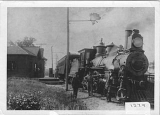
The Hamilton and Lake Erie Railway (H&LE) is a historical shortline railway in Ontario, Canada. It ran from Hamilton to Port Dover, about 40 miles (64 km), providing trans-shipping service between Lake Erie and Lake Ontario, and with connections, to Lake Huron at Georgian Bay.

<span class="mw-page-title-main">Hamilton Radial Electric Railway</span>

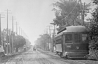
The Hamilton Radial Electric Railway (HRER) was an interurban electric railway which at its maximum extent operated between Hamilton and Oakville in Ontario, Canada.

References

  1. Hilton, George W.; Due, John Fitzgerald (1960). The Electric Interurban Railways in America. Stanford, CA: Stanford University Press. ISBN   978-0-8047-4014-2. OCLC   237973.
  2. 1 2 3 4 5 6 7 8 9 Luton, Tom (August 1, 2022). "The Brantford & Hamilton Electric Railway (B&H)". Hamilton Transit History.
  3. 1 2 3 4 5 6 7 8 9 10 11 John M. Mills (1971). Cataract Traction The Railways of Hamilton. Ontario Electric Railway Historical Association. pp. 59–69.
  4. "Chedoke Radial Trail". Ontario Trails Council . Retrieved January 18, 2021.
  5. "Radial Right of Way Ancaster". Google Maps. Retrieved February 23, 2023.