Purgitsville is an unincorporated community in Hampshire County in the U.S. state of West Virginia. According to the 2000 census, the ZCTA for Purgitsville had a population of 813. Purgitsville is located on U.S. Highway 220/West Virginia Route 28 at its intersection with Huffman Road south of Junction. An elementary school, Mill Creek Elementary, was open here until 1993 when it was consolidated with Romney Elementary.

Rio is an unincorporated community in southern Hampshire County in the U.S. state of West Virginia. Rio is located just north of the Hardy County line at the crossroads of Augusta-Ford Hill Road and Delray Road in the North River Valley. According to the 2000 census, the Rio community has a population of 154.
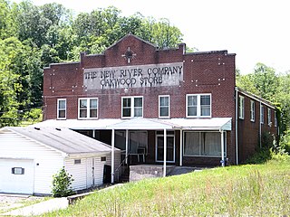
Lehew is an unincorporated community in Hampshire County, West Virginia, United States on the Virginia state line. Lehew is located on Timber Ridge along West Virginia Route 259 at its crossroads with H.G. Brill Road and White Pine Ridge Road.
Rada is an unincorporated community in Hampshire County in the U.S. state of West Virginia. Rada is located on U.S. Highway 220/West Virginia Route 28 between Junction and Purgitsville in southwest Hampshire County along Mill Creek. It lies at an intersection of US 220/WV 28 with Rada Road.
Tabler Station is an unincorporated community in Berkeley County, West Virginia, United States. It lies on County Route 32, south of Martinsburg off U.S. Route 11 near Eastern West Virginia Regional Airport.
Scherr is an unincorporated community in Grant County, West Virginia, United States. The community's name is pronounced like "sheer." Scherr lies to the west of the community of Greenland at the crossroads of West Virginia Route 42, West Virginia Route 93, and U.S. Route 48. Scherr is home to a rock quarry, asphalt plant, and a small country store.
Gilliam is an unincorporated community on the North Fork River in McDowell County, West Virginia, United States. It lies between Algoma and Rolfe along County Route 17.

Quick is a small unincorporated community in Kanawha County, West Virginia, United States. It is located along Indian Creek Road. The community is where Whitoak Fork and Blue Creek come together and meet. It is also where the abandoned railroad that follows Blue Creek joins the road, and follows it all the way to the community of Hitop, along Pond Fork. Its post office is closed.
Belva is an unincorporated community and census-designated place in west Nicholas County and north Fayette County, West Virginia, United States; while the CDP only includes the Nicholas County portion, the Fayette County portion is considered part of the community. The town is situated at the bottomland surrounding the convergence of Bells Creek with Twentymile Creek and, subsequently, Twenty Mile Creek with the Gauley River. Belva is also the location of the convergence of two state highways: West Virginia Route 16 and West Virginia Route 39.
Tioga is a census-designated place (CDP) in northeastern Nicholas County, West Virginia, United States. As of the 2010 census, its population was 98. The town is located along a road alternatively called Tioga Road in Nicholas County and Strouds Creek Road in Webster County. The road can be accessed from West Virginia Route 20 in Allingdale and West Virginia Route 55 near Craigsville.
Maben is an unincorporated community in Wyoming County, West Virginia, United States, along the Slab Fork and West Virginia Route 54. The community is home to Integrated Resources of Wyoming County as well as the county's only 7 Eleven.

Landisburg is an unincorporated community in Fayette County, West Virginia, United States. Landisburg is located along West Virginia Route 41, 11 miles (18 km) east of Oak Hill.
Surveyor is an unincorporated community in Raleigh County, West Virginia, United States. Surveyor is located on West Virginia Route 305, 7 miles (11 km) west of Beckley. Surveyor has a post office with ZIP code 25932.
Crow is an unincorporated community in Raleigh County, West Virginia, United States. Crow is located on West Virginia Route 307, 6 miles (9.7 km) east-southeast of Beckley.
Carlisle is an unincorporated community in Fayette County, West Virginia, United States. Carlisle is located on West Virginia Route 612, 2 miles (3.2 km) southwest of Oak Hill.
Dickinson, also known as Quincy, is an unincorporated community in Kanawha County, West Virginia, United States. Dickinson is located on the north bank of the Kanawha River, 3 miles (4.8 km) southeast of Belle. The community is served by U.S. Route 60.
Liverpool is an unincorporated community in Jackson and Roane counties, West Virginia, United States. Liverpool is located along the Right Fork Sandy Creek at the junction of Jackson County Route 13 and Roane County Route 1, 5.7 miles (9.2 km) west of Reedy Liverpool had a post office, which closed on May 30, 1989. The community was named after Liverpool, in England.
Mead is an unincorporated community in Raleigh County, West Virginia, United States. Mead is located on County Route 33 and Stonecoal Creek, 2.7 miles (4.3 km) east-northeast of Rhodell. Mead had a post office, which closed on June 10, 1989. It was also known as Vanwood.
McAlpin is an unincorporated community in Raleigh County, West Virginia, United States. McAlpin is located on County Route 30 and Winding Gulf, 1.9 miles (3.1 km) west-southwest of Sophia.


