Bremo Bluff, Virginia

Last updated

Bremo Bluff
Bremo Bluff, Virginia USGS 1994.jpeg
Aerial photo of Bremo Bluff in 1994
USA Virginia location map.svg
Red pog.svg
Bremo Bluff
Location within the Commonwealth of Virginia
Usa edcp location map.svg
Red pog.svg
Bremo Bluff
Bremo Bluff (the United States)
Coordinates: 37°42′43″N78°17′53″W / 37.712°N 78.298°W / 37.712; -78.298
CountryUnited States
State Virginia
County Fluvanna
Land patent March 6, 1636
Elevation
452 ft (138 m)
Population
 (2010) [1]
  Total656
Time zone UTC−5 (Eastern (EST))
  Summer (DST) UTC−4 (EDT)
ZIP codes
23022
Area code 434 [1]

Bremo Bluff is an unincorporated community located on the northern bank of the James River in Fluvanna County, Virginia, United States. [1] The locale was established by the Cocke family in 1636. [2] During the American Civil War, the family of General Robert E. Lee sought refuge in the community. [3] It is home to Bremo Power Station, which, at one point, generated 3 percent of the total electricity delivered by utility company Dominion Energy. [4]

Contents

History

Bremo Plantation Bremo Plantation (Fluvanna County, Virginia).jpg
Bremo Plantation

The history of Bremo Bluff can be traced back to the prominent Cocke family of the Tidewater region of Virginia. [5] Richard Cocke, an English immigrant, was granted a land patent on March 6, 1636, that covered 3,000 acres (12 km2) along the James River. [2] The Cocke family settlement was named "Bremo" after their ancestral home of Braemore in the United Kingdom. [5]

To retain their claim as descendants, the brothers Benjamin and Richard Cocke cleared and developed the area of Bremo Bluff around 1725. In 1808, John Hartwell Cocke II began building a plantation estate of three houses, which he named Bremo. He invested in the James River and Kanawha Company to develop a series of locks and canals that began operating around 1840 to improve river transportation. A boat wharf was built to accommodate the river traffic that became an important part of the local economy by the 1850s. However, a series of floods and the American Civil War brought an end to this era. [5]

Mary Anna Custis Lee Mary Anna Custis Lee cropped.jpg
Mary Anna Custis Lee

Mary Anna Custis Lee, the wife of the Confederate general Robert E. Lee, stayed in the Fluvanna County area on several occasions as a safe haven from the Civil War. [3] She spent time at the Bremo Plantation, [6] where her family friend and owner, Dr. Cary Charles Cocke, had a special bed built to accommodate her needs because of rheumatoid arthritis. She was usually accompanied by her son Rob and daughters Agnes and Mildred. Despite the risk of prosecution, Mary Anna Custis Lee and Dr. Cocke taught slaves to read, which was illegal at that time in the Confederate States of America, as they were opposed to slavery. [3]

In November 1865 after the war, the Lee family departed for Lexington, Virginia, where Robert E. Lee had become the president of Washington College. A few months before the death of her husband in 1870, Mary Anna Custis Lee returned to visit the area once again. [3]

Industrial development

The remnants of the local canal route were acquired by the Richmond and Allegheny Railroad in 1880 to build a new railway. Bremo Bluff soon became one of the five busiest stops for passenger and freight traffic. By 1918, four trains each day were stopping at the town. [5]

In 1931, the Virginia Electric & Power Company constructed a 30-megawatt coal-fired power station along the path of the James River Line at Bremo Bluff. [4] [7] The Chesapeake and Ohio Railroad's Strathmore Yard, located nearby to the west, was once a junction to the Virginia Air Line Railway, but was later abandoned. The railway along the James River is now owned by CSX Transportation and is connected by the Buckingham Branch Railroad to Dillwyn, Virginia, which provides the coal to feed the power station. [8]

Bremo Power Station was operated most recently by Dominion Energy. An 80-megawatt generator entered service in 1950, followed by a 170-megawatt unit in 1958. After the original 30-megawatt system was shut down in 1972, total capacity has remained over 240 megawatts, delivered over a 30,000 sq mi (78,000 km2) area. [4] On June 25, 2008, the Virginia Air Pollution Control Board voted to require Dominion Resources to adapt the plant to utilize natural gas. [9] The power station is scheduled to be completely demolished by the end of 2022. [10]

Landmarks

Bremo Slave Chapel Bremo slave chapel.jpg
Bremo Slave Chapel

Bremo Bluff can be accessed from U.S. Route 15 and lies across the James River from Buckingham County, Virginia to the south. The historic area of the village, called "Bachelor's Quarters", is located along Route 657. [5]

Nearby to the west, the Bremo Historic District includes the Cocke family plantation and is a National Historic Landmark. Based on the Palladian architecture of Thomas Jefferson, the plantation mansion was designed by John Hartwell Cocke with master builder John Neilson, who had worked with Jefferson on Monticello. The estate once included the Bremo Slave Chapel, which has since been moved to the center of the Blemo Bluff village and is now listed on the National Register of Historic Places. [11] [12]

Also listed on the National Register of Historic Places are Glen Arvon and Rivanna Farm. [13]

Demographics

Bremo Bluff is part of the Charlottesville metropolitan area. The local zip code of 23022 was populated by 328 men and 328 women in 2010. The median ages of the men and women were 40.8 and 41.8, respectively. The average home value was $56,000 and the average annual household income was $54,396. 129 people were employed across 14 local businesses, generating a total annual payroll of $6,243,000 as of 2010. [1]

Geology

The "Big Sandstone" vein of quartzite was discovered at Bremo Bluff by the Tellurium Mine, [14] which also had been a source of various precious metals since 1832. [15]

Climate

The climate of Bremo Bluff is characterized by relatively high temperatures and evenly distributed precipitation throughout the year. The Köppen Climate Classification subtype for this climate is "Cfa" (Humid temperate hot summer). [16]

Climate data for Bremo Bluff, Virginia(1991-2020 Normals)
MonthJanFebMarAprMayJunJulAugSepOctNovDecYear
Average high °C (°F)9.4
(48.9)
11.6
(52.8)
16.3
(61.4)
22.6
(72.6)
26.7
(80.1)
30.9
(87.6)
33.2
(91.7)
32.3
(90.1)
28.6
(83.5)
22.7
(72.9)
16.5
(61.7)
11.2
(52.2)
21.8
(71.3)
Average low °C (°F)−5.5
(22.1)
−4.5
(23.9)
−0.9
(30.3)
4.3
(39.8)
9.9
(49.9)
14.7
(58.5)
17.4
(63.3)
16.6
(61.9)
12.4
(54.4)
5.2
(41.3)
−0.8
(30.6)
−3.8
(25.2)
5.4
(41.8)
Average precipitation mm (inches)84
(3.30)
71
(2.79)
102
(4.01)
83
(3.28)
123
(4.86)
109
(4.28)
130
(5.13)
97
(3.81)
105
(4.15)
101
(3.99)
92
(3.63)
92
(3.62)
1,189
(46.85)
Source: NOAA [17]

Related Research Articles

<span class="mw-page-title-main">Fluvanna County, Virginia</span> County in Virginia, United States

Fluvanna County is a county located in the Piedmont region of the Commonwealth of Virginia, United States. As of the 2020 census, the population was 27,249. Its county seat is Palmyra, while the most populous community is the census designated place of Lake Monticello.

<span class="mw-page-title-main">George Washington Parke Custis</span> Step-grandson of George Washington (1781–1857)

George Washington Parke Custis was an American plantation owner, antiquarian, author, and playwright. His father John Parke Custis was the stepson of George Washington. He and his sister Eleanor grew up at Mount Vernon and in the Washington presidential household.

Buckingham Branch Railroad is a Class III short-line railroad operating over 275 miles (443 km) of historic and strategic trackage in Central Virginia. Sharing overhead traffic with CSX and Amtrak, the company's headquarters are in Dillwyn, Virginia in the former Chesapeake and Ohio Railroad (C&O) station, itself a historic landmark in the community. The railroad was featured in the January 2012 issue of Trains Magazine. It is referenced in the How It’s Made episode “Railway Bridge Ties”, showing it crossing a curved bridge.

Virginia Air Line Railroad (VAL) was a short-line railroad that operated from 1908 to 1975 in Central Virginia. It was built by the Virginia Air Line Railway Company to connect the Chesapeake and Ohio Railroad's (C&O) Piedmont Subdivision at Lindsay, Virginia, to the Rivanna Subdivision of C&O's James River Line at Strathmore Yard, near Bremo Bluff, Virginia.

<span class="mw-page-title-main">Varina, Virginia</span> Former unincorporated community and current magisterial district in Virginia, United States

Varina is a former unincorporated community and current magisterial district in the easternmost portion of Henrico County, Virginia, United States.

<span class="mw-page-title-main">Mary Anna Custis Lee</span> Wife of Robert E. Lee (1807–1873)

Mary Anna Randolph Custis Lee was the wife of the Confederate general Robert E. Lee and the last private owner of Arlington Estate. She was the daughter of George Washington Parke Custis who was the grandson of Martha Dandridge Custis Washington, the wife of George Washington.

<span class="mw-page-title-main">U.S. Route 15 in Virginia</span> Highway in Virginia

U.S. Route 15 (US 15) is a part of the United States Numbered Highway System that runs from Walterboro, South Carolina, to Painted Post, New York. In Virginia, the U.S. Highway runs 230.37 miles (370.74 km) from the North Carolina state line near Clarksville north to the Maryland state line at the Potomac River near Lucketts. US 15 is a major north–south highway through the Piedmont of Virginia, connecting Clarksville and Farmville in Southside with Culpeper, Warrenton, and Leesburg in Northern Virginia.

<span class="mw-page-title-main">Edward Randolph</span>

Edward Randolph, sometimes referred to as Edward Randolph of Bremo, was a ship captain, a London tobacco merchant, and the seventh and youngest son of William Randolph and Mary Isham.

<span class="mw-page-title-main">Bremo Slave Chapel</span> Only slave chapel known to exist in the Commonwealth of Virginia

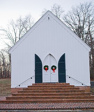
Bremo Slave Chapel, constructed in 1835 and located in Bremo Bluff, Virginia, United States, is the only slave chapel known to exist in the Commonwealth of Virginia. This Gothic Revival structure originally served as a place of worship for the slaves at the Bremo Plantation of General John Hartwell Cocke. Cocke was deeply concerned with the religious and moral state of his slaves, which drove him to construct this chapel.

<span class="mw-page-title-main">Bremo Historic District</span> Historic district in Virginia, United States

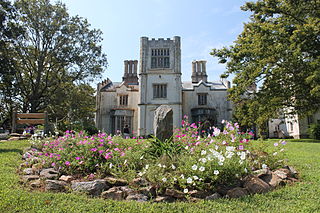
Bremo, also known as Bremo Plantation or Bremo Historic District, is a plantation estate covering over 1,500 acres (610 ha) on the west side of Bremo Bluff in Fluvanna County, Virginia. The plantation includes three separate estates, all created in the 19th century by the planter, soldier, and reformer John Hartwell Cocke on his family's 1725 land grant. The large neo-palladian mansion at "Upper" Bremo was designed by Cocke in consultation with John Neilson, a master joiner for Thomas Jefferson's Monticello. The Historic District also includes two smaller residences known as Lower Bremo and Bremo Recess.

<span class="mw-page-title-main">Philip St. George Cocke</span>

Philip St. George Cocke was a brigadier general in the Confederate States Army during the first year of the American Civil War. He is best known for organizing the defense of Virginia along the Potomac River soon after the state's secession from the Union. He commanded troops in the Battle of Blackburn's Ford and the First Battle of Bull Run in July 1861 before becoming despondent and committing suicide.

<span class="mw-page-title-main">John Hartwell Cocke</span> American military officer, planter and businessman (1780–1866)

Brigadier-General John Hartwell Cocke II was an American military officer, planter and businessman. During the War of 1812, Cocke served in the Virginia militia. After his military service, he invested in the James River and Kanawha Canal and helped Thomas Jefferson establish the University of Virginia. The family estate that Cocke built at Bremo Plantation is now a National Historic Landmark.

Carysbrook is an unincorporated community in Fluvanna County, in the U.S. state of Virginia.

Cohasset is an unincorporated community in Fluvanna County, in the U.S. state of Virginia located about two miles west of Fork Union on State Route 6.

<span class="mw-page-title-main">Glen Arvon</span> Historic house in Virginia, United States

Glen Arvon, originally known as Glenarvon, is a historic plantation house and farm located near Bremo Bluff, Fluvanna County, Virginia. The main house was built in 1836, and is a two-story, five bay, brick dwelling in the Greek Revival style. It measures 50 feet by 40 feet and is topped by a shallow hipped roof with balustrade. The front facade features a two-story Greek Doric order portico. Also on the property is the contributing two-story, brick servant's house. The house is a twin of Point of Fork, as they were built by brothers William and James Galt.

<span class="mw-page-title-main">Belmead (Powhatan, Virginia)</span> Historic house in Virginia, United States

Belmead is a historic plantation located near Powhatan, Powhatan County, Virginia, designed by architect Alexander Jackson Davis for Philip St. George Cocke — and constructed about 1845.

<span class="mw-page-title-main">Seven Islands Archeological and Historic District</span> Archaeological site in Virginia, United States

The Seven Islands Archeological and Historic District encompasses a 312-acre (126 ha) site near the confluence of the James and Slate Rivers in Buckingham and Fluvanna Counties in Virginia. The site is notable for a number of prehistoric archaeological sites, the largest of which is a Woodland period Native American site, while smaller sites from earlier periods also exist in the area. The site is also notable for the Seven Islands house, a well-preserved Greek Revival I-house. It is situated on a bluff in Buckingham County with commanding views of the James River, across from the Bremo Plantation.

<span class="mw-page-title-main">Swann's Point Plantation Site</span> Archaeological site and former plantation in Virginia, USA

The Swann's Point Plantation Site is an archaeological site near the James River in Surry County, Virginia. The Swann's Point area, located west of the mouth of Gray Creek, has a rich historic of precolonial Native American occupation, as well as significant early colonial settlements. It was first granted to Richard Pace, whose warning famously saved the Jamestown Colony during the Indian Massacre of 1622. The Paces abandoned their settlement in 1624.

The John H. Cocke Memorial Bridge is a bridge along U.S. Route 15 in the state of Virginia that crosses over the James River. Its northern terminus is at Bremo Bluff, VA and the Bremo Historic District in southern Fluvanna County and its southern terminus is at New Canton, Virginia in northern Buckingham County. The bridge is named in honor of John Hartwell Cocke, a notable Virginian whose Bremo Plantation was nearby and who once owned the property on which it was built.

John Neilson (c.1770—1827) was an Irish immigrant to the United States who eventually settled in Virginia and became a prominent 19th-century master carpenter and joiner, as well as architect and builder. He is most known for his work at Monticello, Montpelier, Bremo, and the University of Virginia.

References

  1. 1 2 3 4 "23022 Zip Code Profile". Neighborhood Link. Retrieved December 1, 2010.
  2. 1 2 Moore, William Cabell (October 1933). "Gen. John Hartwell Cocke of Bremo 1780–1866: A Brief Biography and Genealogical Review with a Short History of Old Bremo". William and Mary Quarterly . The College of William & Mary. 13 (4): 207–218. JSTOR   1919767.
  3. 1 2 3 4 Holen, O.T. (June 26, 2008). "Mrs. Robert E. Lee's Visit(s) to Bremo Bluff". Fluvanna Review. Retrieved December 4, 2010.[ permanent dead link ]
  4. 1 2 3 "Bremo Power Station". Dominion Resources. 2008. Archived from the original on December 5, 2010. Retrieved November 30, 2010.
  5. 1 2 3 4 5 Browning, Sally (February 26, 2004). "Bremo Bluff: From Beginning to End". Fluvanna Review. Archived from the original on July 8, 2011. Retrieved December 4, 2010.{{cite journal}}: CS1 maint: bot: original URL status unknown (link)
  6. Thompson, Mary V. (August 22, 2006). "Statements by Washington/Custis Family Members Concerning Religion, God, Life, Death, Charity, and Morality" (PDF). The Mount Vernon Ladies' Association. Archived from the original (PDF) on August 4, 2010. Retrieved December 6, 2010.
  7. "Dominion History". Dominion Resources. 2008. Archived from the original on December 5, 2010. Retrieved November 30, 2010.
  8. Wilson, Paul A. (February 18, 1998). "Buckingham Branch Railroad". TrainWeb. Retrieved December 1, 2010.
  9. Kranz, Garry; Squires, Paula C. (July 1, 2008). "Keeping the lights on in a low-carbon world". Virginia Business. Retrieved December 4, 2010.
  10. Michon, Heather (June 15, 2022). "Demolition of Bremo Power Station to be completed by year's end". Fluvanna Review. Retrieved September 22, 2022.
  11. Loth, Calder (1999). "Fluvanna County". The Virginia Landmarks Register. University of Virginia Press: 172. Retrieved December 3, 2010.
  12. Chiat, Marilyn Joyce Segal (1997). "Bremo Slave Chapel". America's Religious Architecture: Sacred Places for Every Community. New York City: John Wiley & Sons: 237. Retrieved December 3, 2010.
  13. "National Register Information System". National Register of Historic Places . National Park Service. July 9, 2010.
  14. Taber, Stephen (1913). "Geology of the Gold Belt in the James River Basin". Bulletin, Virginia Division of Mineral Resources, Virginia Geological Survey, Virginia Division of Geology. Charlottesville: University of Virginia: 16–19. Retrieved December 2, 2010. bremo bluff.
  15. "Tellurium Mine". Mindat.org . Retrieved December 1, 2010.
  16. Climate Summary for Bremo Bluff, Virginia
  17. "weather.gov". NOAA. 2023. Retrieved on August 23, 2023.

Further reading