Brian McClendon

Last updated

Brian McClendon
Brian McClendon 7-21-11.jpg
Personal details
Born1964 (age 5960)
Political party Democratic
SpouseBeth Ellyn McClendon
Education University of Kansas, Lawrence (BS)

Brian A McClendon (born 1964) is an American software executive, engineer, and inventor. [1] He was a co-founder and angel investor in Keyhole, Inc., a geospatial data visualization company that was purchased by Google in 2004 [2] [3] to produce Google Earth. Keyhole itself was spun off from another company called Intrinsic Graphics, of which McClendon was also a co-founder. McClendon was elected a member of the National Academy of Engineering in 2015 for strategic, technical, and managerial leadership resulting in widespread accurate and useful geographic information.

Contents

Early life

McClendon grew up in Lawrence, Kansas. His childhood home, Meadowbrook Apartments in Lawrence, is the default center point of Google Earth. [4] He graduated from Lawrence High School in 1982 and from the University of Kansas in 1986 with a degree in electrical engineering. [5]

Career

Early years

McClendon spent eight years with Silicon Graphics developing high-end workstation 3D graphics including GT, GTX, RealityEngine, and InfiniteReality, and then worked as an engineering director with @Home Network.

Keyhole

In 2001, he was one of the original investors in Keyhole, Inc., a software development company specializing in geospatial data visualization applications. He served as a board member and later joined the company as vice president of engineering.

Google

When Google acquired Keyhole in 2004, McClendon became a director of engineering [6] for Google Geo, a team focussed on geospatial data visualization applications. He was later promoted to vice president, overseeing the Geo team. [7]

Keyhole's main application suite, Earth Viewer, and Keyhole Markup Language (KML), formed the basis for Google Earth. Under McClendon's tenure, Google Geo products included Google Maps, Google Maps API, Street View, Google Local Search, Panoramio, Sketchup, Waze, Google Earth, and Google Earth Engine. Brian was also instrumental in the creation of Google Santa Tracker [8]

Uber

He left Google to join Uber in June 2015 to work on mapping and machine learning. [9]

Niantic

In November, 2021, McClendon joined Niantic as a senior vice president of augmented reality, research and mapping [10]

Politics

In March 2017, McClendon resigned his full-time role at Uber, though remaining an adviser, in order to return to his hometown of Lawrence, Kansas, indicating an interest in politics. [11] In January 2018, he announced his intention to run for Kansas Secretary of State as a Democrat. [12] He ran unopposed in the primary election and was selected as the Democratic candidate. [13] He was defeated in the general election by Republican candidate Scott Schwab. [14]

Teaching and philanthropy

McClendon maintains close ties with his alma mater, the University of Kansas, serving on advisory boards for both the School of Engineering and the Department of Electrical Engineering and Computer Science. He and his wife Beth Ellyn McClendon established the McClendon Engineering Scholarship at the university in 2007, donated computer tablets for electrical engineering and computer science students, and provided a Google Liquid Galaxy interactive display at the University's Eaton Hall.

In 2013, he served as Grand Marshal of the University's homecoming parade. [15]

He currently serves as a research professor at the University of Kansas, having received an honorary doctorate in electrical engineering from the university in 2015. [16] His research subjects include machine learning, autonomous vehicles, and world-scale mapping. [16]

Awards and recognitions

McClendon received an honorary doctorate from his alma mater, the University of Kansas, "for outstanding contributions to the fields of electrical engineering and computer science." He has been recognized by the United Nations as a Champions of the Earth in 2013, which is its top environmental prize, "for harnessing the power of technology to support conservation and green economic development." [17]

McClendon holds 41 issued patents, [18] including thirteen relating to KML, [19] the XML-based language schema for expressing geographic annotation and visualization in two-dimensional maps and three-dimensional Earth browsers. KML became an open standard for GIS data in 2008. [20]

Depiction in media

See also

Related Research Articles

A GIS file format is a standard for encoding geographical information into a computer file, as a specialized type of file format for use in geographic information systems (GIS) and other geospatial applications. Since the 1970s, dozens of formats have been created based on various data models for various purposes. They have been created by government mapping agencies, GIS software vendors, standards bodies such as the Open Geospatial Consortium, informal user communities, and even individual developers.

<span class="mw-page-title-main">NASA WorldWind</span> Open-source virtual globe

NASA WorldWind is an open-source virtual globe. According to the website, "WorldWind is an open source virtual globe API. WorldWind allows developers to quickly and easily create interactive visualizations of 3D globe, map and geographical information. Organizations around the world use WorldWind to monitor weather patterns, visualize cities and terrain, track vehicle movement, analyze geospatial data and educate humanity about the Earth." It was first developed by NASA in 2003 for use on personal computers and then further developed in concert with the open source community since 2004. As of 2017, a web-based version of WorldWind is available online. An Android version is also available.

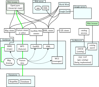
In computing, GeoServer is an open-source server written in Java that allows users to share, process and edit geospatial data. Designed for interoperability, it publishes data from any major spatial data source using open standards. GeoServer has evolved to become an easy method of connecting existing information to virtual globes such as Google Earth and NASA World Wind as well as to web-based maps such as OpenLayers, Leaflet, Google Maps and Bing Maps. GeoServer functions as the reference implementation of the Open Geospatial Consortium Web Feature Service standard, and also implements the Web Map Service, Web Coverage Service and Web Processing Service specifications.

A GIS software program is a computer program to support the use of a geographic information system, providing the ability to create, store, manage, query, analyze, and visualize geographic data, that is, data representing phenomena for which location is important. The GIS software industry encompasses a broad range of commercial and open-source products that provide some or all of these capabilities within various information technology architectures.

<span class="mw-page-title-main">Google Earth</span> 3D Internet global map program

Google Earth is a computer program that renders a 3D representation of Earth based primarily on satellite imagery. The program maps the Earth by superimposing satellite images, aerial photography, and GIS data onto a 3D globe, allowing users to see cities and landscapes from various angles. Users can explore the globe by entering addresses and coordinates, or by using a keyboard or mouse. The program can also be downloaded on a smartphone or tablet, using a touch screen or stylus to navigate. Users may use the program to add their own data using Keyhole Markup Language and upload them through various sources, such as forums or blogs. Google Earth is able to show various kinds of images overlaid on the surface of the Earth and is also a Web Map Service client. In 2019, Google revealed that Google Earth now covers more than 97 percent of the world, and has captured 10 million miles of Street View imagery.

Keyhole Markup Language (KML) is an XML notation for expressing geographic annotation and visualization within two-dimensional maps and three-dimensional Earth browsers. KML was developed for use with Google Earth, which was originally named Keyhole Earth Viewer. It was created by Keyhole, Inc, which was acquired by Google in 2004. KML became an international standard of the Open Geospatial Consortium in 2008. Google Earth was the first program able to view and graphically edit KML files, but other projects such as Marble have added KML support.

The concept of a Geospatial Web may have first been introduced by Dr. Charles Herring in his US DoD paper, An Architecture of Cyberspace: Spatialization of the Internet, 1994, U.S. Army Construction Engineering Research Laboratory.

Digital Earth is the name given to a concept by former US vice president Al Gore in 1998, describing a virtual representation of the Earth that is georeferenced and connected to the world's digital knowledge archives.

<span class="mw-page-title-main">OpenLayers</span> JavaScript library for displaying map data in web browsers

OpenLayers is an open-source JavaScript library for displaying map data in web browsers as slippy maps. It provides an API for building rich web-based geographic applications similar to Google Maps and Bing Maps.

<span class="mw-page-title-main">John Hanke</span> American technology executive (born 1967)

John Hanke is an American technology executive. Hanke led Google's Geo product division, which includes Google Earth, Google Maps, StreetView, SketchUp, and Panoramio. He is founder and CEO of Niantic, Inc., a software company spun out of Google and the creator of Pokémon Go.

<span class="mw-page-title-main">Family tree mapping</span>

Family tree mapping is the process of geocoding places in family tree files to produce geospatial data suitable for viewing with a virtual globe or 2D mapping program.

The University of Kansas School of Engineering, founded in 1891 is the oldest Engineering School in the State of Kansas, although engineering degrees were awarded as early as 1873. It is an ABET accredited, public engineering school located on the main campus of the University of Kansas in Lawrence, Kansas.

Neogeography is the use of geographical techniques and tools for personal and community activities or by a non-expert group of users. Application domains of neogeography are typically not formal or analytical.

<span class="mw-page-title-main">Google Fusion Tables</span> Data management web service

Google Fusion Tables was a web service provided by Google for data management. Fusion tables was used for gathering, visualising and sharing data tables. Data are stored in multiple tables that Internet users can view and download.

<span class="mw-page-title-main">Open Geospatial Consortium</span> Standards organization

The Open Geospatial Consortium (OGC), an international voluntary consensus standards organization for geospatial content and location-based services, sensor web and Internet of Things, GIS data processing and data sharing. It originated in 1994 and involves more than 500 commercial, governmental, nonprofit and research organizations in a consensus process encouraging development and implementation of open standards.

<span class="mw-page-title-main">Google Santa Tracker</span> Website that simulates tracking Santa Claus

Google Santa Tracker is an annual Christmas-themed entertainment website first launched in 2004 by Google that simulates the tracking of the legendary character Santa Claus on Christmas Eve, using pre-determined location information. It also allows users to play, watch, and learn through various Christmas-themed activities. The service was inspired by NORAD Tracks Santa, which has operated since 1955.

The Billion Dollar Code is a 2021 German television miniseries starring Björn Freiberg, Seumas F. Sargent and Leonard Scheicher. Based on true events, the series was developed for Netflix, where it was first aired in October 2021 along with an additional feature story episode.

<span class="mw-page-title-main">Terravision (computer program)</span> Computer program

Terravision is a 3D mapping software developed in 1993 by the German company ART+COM in Berlin as a "networked virtual representation of the Earth based on satellite images, aerial shots, altitude data and architectural data". Development of the project was supported by the Deutsche Post.

<span class="mw-page-title-main">Web GIS</span> Technologies employing the World Wide Web to manage spatial data

Web GIS, or Web Geographic Information Systems, are GIS that employ the World Wide Web to facilitate the storage, visualization, analysis, and distribution of spatial information over the Internet. The World Wide Web, or the Web, is an information system that uses the internet to host, share, and distribute documents, images, and other data. Web GIS involves using the World Wide Web to facilitate GIS tasks traditionally done on a desktop computer, as well as enabling the sharing of maps and spatial data. While Web GIS and Internet GIS are sometimes used interchangeably, they are different concepts. Web GIS is a subset of Internet GIS, which is itself a subset of distributed GIS, which itself is a subset of broader Geographic information system. The most common application of Web GIS is Web mapping, so much so that the two terms are often used interchangeably in much the same way as Digital mapping and GIS. However, Web GIS and web mapping are distinct concepts, with web mapping not necessarily requiring a Web GIS.

References

  1. "Google's Road Map to Global Domination". The New York Times Magazine. December 11, 2013.
  2. "Google Acquires Keyhole Corp" (Press release). Mountain View, California. October 27, 2004. Retrieved November 7, 2018.
  3. "Google Buys Digital Mapping Company". PC World. October 27, 2004. Archived from the original on August 4, 2012. Retrieved March 31, 2010.
  4. "Lawrence Pinpointed as Center of Google Earth". Lawrence Journal World. December 21, 2005.
  5. "Brian McClendon: Alumni Spotlight". University of Kansas Center for Undergraduate Research. February 2014. Archived from the original on June 13, 2021. Retrieved February 1, 2023.
  6. "Greensburg, Kansas, Tornado Imagery". Google Maps. May 9, 2007.
  7. "Google's Road Map to Global Domination". The New York Times Magazine. December 11, 2013.
  8. "Tracking Santa: the Backstory". Official Google Blog. Google. Retrieved December 22, 2022.
  9. "Uber Hires Google’s Former Head of Maps to Oversee Location Technology, Pittsburgh Center" re code, June 16, 2015 Archived August 16, 2015, at the Wayback Machine
  10. Dorrian, Blythe (December 7, 2021). "Former Google, Uber exec joins maker of Pokémon Go — and he's building a team of developers in Lawrence". Startland News. Retrieved July 1, 2022.
  11. "Uber's Head of Mapping Leaves, Wants to go Home". USA Today. March 20, 2017.
  12. "Former Tech Exec, Lawrence native Brian McClendon announces run for Kansas secretary of state". Lawrence Journal. January 22, 2018.
  13. "2018 Primary Election Official Vote Totals" (PDF). August 31, 2018.
  14. "Kansas Republicans win races for secretary of state, insurance commissioner, attorney general, treasurer; Estes and Marshall keep congressional seats".
  15. "Google's Brian McClendon to serve as grand marshal for KU Homecoming parade". University of Kansas. September 13, 2013.
  16. 1 2 "Brian McClendon". University of Kansas Electrical Engineering and Computer Science. Retrieved March 8, 2021.
  17. "University of Kansas Honorary Degrees profile for Brian McClendon". October 14, 2015. Retrieved November 7, 2018.
  18. "US Patent Database Search Results: IN/"McCLendon, Brian" in US Patent Collection" . Retrieved November 7, 2018.
  19. "Patent Database Search Results: IN/"McCLendon, Brian" AND "Keyhole markup language" in US Patent Collection" . Retrieved November 7, 2018.
  20. "OGC Approves KML as Open Standard". OGC. Retrieved November 7, 2018.
  21. Jennings, Ken (2011). Maphead : charting the wide, weird world of geography wonks. S. McArthur (1st Scribner hardcover ed.). New York: Scribner. ISBN   978-1-4391-6717-5. OCLC   687665983.
  22. Kilday, Bill (2018). Never Lost Again: the Google mapping revolution that sparked new industries and augmented our reality (First ed.). New York, New York. ISBN   978-0-06-267304-6. OCLC   994315355.{{cite book}}: CS1 maint: location missing publisher (link)
  23. Jungen, Oliver. "The Billion Dollar Code: David gegen Googliath". Frankfurter Allgemeine (in German).
  24. Bar-Zeev, Avi (October 24, 2021). "Was Google Earth Stolen? (no)". Medium.
  25. Garfield, Simon (2012). On the map : why the world looks the way it does. London: Profile. ISBN   978-1-84668-509-5. OCLC   819941645.
  26. Garfield, Simon (2013). On the map : a mind-expanding exploration of the way the world looks. New York, New York: Gotham Books. ISBN   978-1-59240-779-8. OCLC   795167619.