Brookridge, Florida

Last updated

Brookridge, Florida
Brookridge, Florida Sign.jpg
The gateway to Brookridge on State Road 50
Hernando County Florida Incorporated and Unincorporated areas Brookridge Highlighted.svg
Location in Hernando County and the state of Florida
Coordinates: 28°32′55″N82°29′26″W / 28.54861°N 82.49056°W / 28.54861; -82.49056
Country United States
State Florida
County Hernando
Area
[1]
  Total2.53 sq mi (6.56 km2)
  Land2.53 sq mi (6.56 km2)
  Water0.00 sq mi (0.00 km2)
Elevation
62 ft (19 m)
Population
 (2020)
  Total4,658
  Density1,838.93/sq mi (710.04/km2)
Time zone UTC-5 (Eastern (EST))
  Summer (DST) UTC-4 (EDT)
ZIP code
34613 [2]
Area code 352
FIPS code 12-08762 [3]
GNIS feature ID1867119 [4]

Brookridge is a census-designated place (CDP) in Hernando County, Florida, United States. The population was 4,420 at the 2010 census, [5] up from 3,279 at the 2000 census.

Contents

Geography

Brookridge is located in central Hernando County at 28°32′55″N82°29′26″W / 28.54861°N 82.49056°W / 28.54861; -82.49056 (28.548698, -82.490423). [6] It is bordered to the east by Florida State Road 589 (the Suncoast Parkway), to the south across Florida State Road 50 by Spring Hill, and to the west by High Point. SR 589 leads south 50 miles (80 km) to Tampa and north 10 miles (16 km) to its terminus at U.S. Route 98 near Sugarmill Woods. SR 50 leads east 6 miles (10 km) to Brooksville, the Hernando County seat, and west 5 miles (8 km) to U.S. Route 19 at Weeki Wachee.

According to the United States Census Bureau, the Brookridge CDP has a total area of 2.5 square miles (6.5 km2), all land. [5]

Demographics

Historical population
CensusPop.Note
2020 4,658
U.S. Decennial Census [7]

As of the census [3] of 2000, there were 3,279 people, 1,823 households, and 1,168 families residing in the CDP. The population density was 1,617.7 inhabitants per square mile (624.6/km2). There were 2,129 housing units at an average density of 1,050.4 per square mile (405.6/km2). The racial makeup of the CDP was 98.87% White, 0.15% African American, 0.09% Native American, 0.18% Asian, 0.21% from other races, and 0.49% from two or more races. Hispanic or Latino of any race were 0.95% of the population.

There were 1,823 households, out of which 2.5% had children under the age of 18 living with them, 59.0% were married couples living together, 4.0% had a female householder with no husband present, and 35.9% were non-families. 33.5% of all households were made up of individuals, and 29.0% had someone living alone who was 65 years of age or older. The average household size was 1.76 and the average family size was 2.14.

In the CDP, the population was spread out, with 2.9% under the age of 18, 1.3% from 18 to 24, 5.4% from 25 to 44, 19.0% from 45 to 64, and 71.4% who were 65 years of age or older. The median age was 72 years. For every 100 females, there were 82.0 males. For every 100 females age 18 and over, there were 81.4 males.

The median income for a household in the CDP was $24,774, and the median income for a family was $30,139. The per capita income for the CDP was $18,122. About 4.2% of families and 5.7% of the population were below the poverty line, including none of those under age 18 and 5.7% of those age 65 or over.

Related Research Articles

<span class="mw-page-title-main">Citrus Hills, Florida</span> Census-designated place in Florida, US

Citrus Hills is a census-designated place (CDP) in Citrus County, Florida, United States. The population was 7,470 at the 2010 census, up from 4,029 in 2000.

<span class="mw-page-title-main">Floral City, Florida</span> Census-designated place in Florida, US

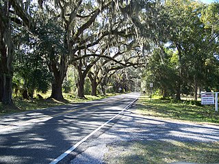
Floral City is a census-designated place (CDP) in Citrus County, Florida, United States. The population was 5,216 at the 2010 census. The community is home to the Floral City Heritage Hall Museum and hosts the Floral City Heritage Days the first weekend in December. The area has a history of phosphate mining and includes historic homes.

<span class="mw-page-title-main">Hernando, Florida</span> Census-designated place in Florida, US

Hernando is a census-designated place in Citrus County, Florida, United States. The population was 9,054 at the 2010 census. At one time it was a city but it was disincorporated in the 1970s.

<span class="mw-page-title-main">Bayport, Florida</span> Census-designated place in Florida, United States

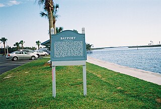
Bayport is an unincorporated community and census-designated place (CDP) in Hernando County, Florida, United States. The population was 43 at the 2010 census.

<span class="mw-page-title-main">Hernando Beach, Florida</span> Census-designated area in Hernando County Florida, United States

Hernando Beach is a census-designated place (CDP) in Hernando County, Florida, United States. The population was 2,299 at the 2010 census.

<span class="mw-page-title-main">High Point, Hernando County, Florida</span> Census-designated place in Florida, United States

High Point is an unincorporated area and census-designated place (CDP) in Hernando County, Florida, United States. The population was 3,686 at the 2010 census.

<span class="mw-page-title-main">Hill 'n Dale, Florida</span> Census-designated place in Florida, United States

Hill 'n Dale is a census-designated place (CDP) in Hernando County, Florida, United States. The population was 1,934 at the 2010 census.

<span class="mw-page-title-main">Istachatta, Florida</span> Census-designated place in Florida, United States

Istachatta is an unincorporated community and census-designated place (CDP) in Hernando County, Florida, United States. The population was 116 at the 2010 census, up from 65 at the 2000 census. The name "Istachatta" is derived from a Seminole word meaning "man snake".

<span class="mw-page-title-main">Lake Lindsey, Florida</span> Census-designated place in Florida, United States

Lake Lindsey is an unincorporated community and census-designated place (CDP) in Hernando County, Florida, United States. The population was 71 at the 2010 census.

<span class="mw-page-title-main">Masaryktown, Florida</span> Census-designated place in Florida, United States

Masaryktown is an unincorporated community and census-designated place (CDP) in Hernando County, Florida, United States. The population was 1,077 at the 2020 census. It is named after the first president of Czechoslovakia, Tomáš Garrigue Masaryk.

<span class="mw-page-title-main">Nobleton, Florida</span> Census-designated place in Florida, United States

Nobleton is an unincorporated community and census-designated place (CDP) in Hernando County, Florida, United States. The population was 282 at the 2010 census, up from 160 at the 2000 census.

<span class="mw-page-title-main">North Brooksville, Florida</span> Census-designated place in Florida, United States

North Brooksville is a census-designated place (CDP) in Hernando County, Florida, United States. The population was 3,544 at the 2010 census. It is a suburb included in the Tampa-St. Petersburg-Clearwater, Florida Metropolitan Statistical Area.

<span class="mw-page-title-main">North Weeki Wachee, Florida</span> Census-designated place in Florida, United States

North Weeki Wachee is a census-designated place (CDP) in Hernando County, Florida, United States. The population was 8,524 at the 2010 census, up from 4,253 at the 2000 census.

<span class="mw-page-title-main">Pine Island, Hernando County, Florida</span> Census-designated place in Florida, United States

Pine Island is an unincorporated community and census-designated place (CDP) in Hernando County, Florida, United States. The population was 64 at the 2010 census, unchanged from the 2000 census.

<span class="mw-page-title-main">Ridge Manor, Florida</span> Census-designated place in Florida, United States

Ridge Manor is a census-designated place (CDP) in Hernando County, Florida, United States. The population was 4,513 at the 2010 census.

<span class="mw-page-title-main">South Brooksville, Florida</span> Census-designated place in Florida, United States

South Brooksville is a census-designated place (CDP) in Hernando County, Florida, United States. The population was 4,007 at the 2010 census. It is a suburb included in the Tampa-St. Petersburg-Clearwater, Florida Metropolitan Statistical Area.

<span class="mw-page-title-main">Spring Hill, Florida</span> Census-designated place in Hernando County Florida, United States

Spring Hill is a census-designated place (CDP) in Hernando County, Florida, United States. The population was 113,568 at the 2020 census, up from 98,621 at the 2010 census. Spring Hill belongs to Florida's Nature Coast region and is in the Tampa-St. Petersburg-Clearwater metro area. It is east of Hernando Beach, southwest of Brooksville, and north of Tampa.

<span class="mw-page-title-main">Spring Lake, Florida</span> Census-designated place in Florida, United States

Spring Lake is an unincorporated community and census-designated place (CDP) in Hernando County, Florida, United States. The population was 458 at the 2010 census, up from 327 at the 2000 census.

<span class="mw-page-title-main">Timber Pines, Florida</span> Census-designated place in Florida, United States

Timber Pines is a census-designated place (CDP) in Hernando County, Florida, United States. The population was 5,386 at the 2010 census.

<span class="mw-page-title-main">Weeki Wachee Gardens, Florida</span> Census-designated place in Florida, United States

Weeki Wachee Gardens is a census-designated place (CDP) in Hernando County, Florida, United States. The population was 1,146 at the 2010 census.

References

Commons-logo.svg Media related to Brookridge, Florida at Wikimedia Commons

  1. "2020 U.S. Gazetteer Files". United States Census Bureau. Retrieved October 31, 2021.
  2. "Brookridge FL ZIP Code". zipdatamaps.com. 2023. Retrieved February 17, 2023.
  3. 1 2 "U.S. Census website". United States Census Bureau . Retrieved January 31, 2008.
  4. "US Board on Geographic Names". United States Geological Survey. October 25, 2007. Retrieved January 31, 2008.
  5. 1 2 "Geographic Identifiers: 2010 Demographic Profile Data (G001): Brookridge CDP, Florida". American Factfinder. U.S. Census Bureau. Retrieved April 26, 2017.[ dead link ]
  6. "US Gazetteer files: 2010, 2000, and 1990". United States Census Bureau. February 12, 2011. Retrieved April 23, 2011.
  7. "Census of Population and Housing". Census.gov. Retrieved June 4, 2016.