Related Research Articles

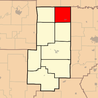
Butler County is a county located in the southeast Ozark Foothills Region in the U.S. state of Missouri. As of the 2020 Census, the county's population was 42,130. The largest city and county seat is Poplar Bluff. The county was officially organized from Wayne County on February 27, 1849, and is named after former U.S. Representative William O. Butler (D-Kentucky), who was also an unsuccessful candidate for Vice President of the United States. The first meeting in the Butler County Courthouse was held on June 18, 1849.
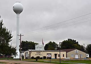
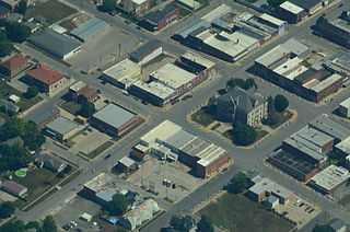
Fisk is a small city in Butler County, Southeast Missouri, United States. It is located right along the Butler-Stoddard County line on U.S. Route 60, along the St. Francis River. The population was 312 at the 2020 census.
Carrollton is a city in Carroll County, Missouri, United States. Carrollton won the 2005 All-America City Award, given out annually by the National Civic League. The population was 3,514 at the 2020 census. Carrollton is the county seat of Carroll County.
QulinKEW-lin is a city located in Butler County in Southeast Missouri, United States. The population was 460 at the 2020 census.
Golden is an unincorporated community and census-designated place in southeastern Barry County, Missouri, United States. It is approximately 20 miles (32 km) southeast of Cassville. It is located south of Table Rock Lake and one mile north of Missouri Route 86 on Highway J. At the 2020 census, Golden had a population of 275.
Eagle Rock is an unincorporated community and census-designated place in Barry County, Missouri, United States. As of the 2020 census, it had a population of 193.
Success is an unincorporated community in Texas County, Missouri, United States. It is located approximately twelve miles northwest of Houston at the southern intersection of Routes 17 and 32.
Dawn is an unincorporated community and census-designated place (CDP) in Livingston County, Missouri, United States. As of the 2020 census it had a population of 100.
Ravanna is a census-designated place in Mercer County, Missouri, United States. It is located approximately seven miles northeast of Princeton on U.S. Route 136. The population was 60 at the 2020 census.
Harviell is an unincorporated community and census-designated place in Butler County, Missouri, United States. As of the 2020 census it had a population of 98.
Deering is an unincorporated community in Pemiscot County, Missouri, United States. It is located fifteen miles west of Caruthersville.

Millersville is an unincorporated community in western Cape Girardeau County, Missouri, United States. It is located six miles (10 km) west of Jackson on Route 72.

Lorance Township is one of eight townships in Bollinger County, Missouri, USA. As of the 2000 U.S. Census, its population was 4,406. As of the 2010 U.S. Census, the population had decreased to 4,366. Lorance Township covers 104.5 square miles (271 km2).

Union Township is one of eight townships in Bollinger County, Missouri, USA. As of the 2000 U.S. Census, its population was 1,035. As of the 2010 U.S. Census, the population had increased to 1,058. Union Township covers an area of 56.99 square miles (147.6 km2).
Whitewater Township is one of eight townships in Bollinger County, Missouri, USA. As of the 2000 U.S. Census, its population was 911. As of the 2010 U.S. Census, the population had increased to 1,029. Whitewater Township covers an area of 51.76 square miles (134.1 km2).
Spring Bluff is an unincorporated community in southwest Franklin County, Missouri, United States.
Connelsville is an unincorporated community in Nineveh Township, Adair County, Missouri, United States. The community is on Missouri Route 149 about three miles north of Novinger and eight miles northwest of Kirksville. Shuteye Creek flows past the north side of the town and its confluence with the Chariton River is about one mile to the east.
Batesville is an unincorporated community in eastern Butler County, in the U.S. state of Missouri. The community is located in the flatlands of southeast Missouri on Missouri Route 51 between Broseley to the south and Rossville to the north. Poplar Bluff is 8.5 miles (13.7 km) to the northwest.
Twin Rivers R-X School District is a school district headquartered in Broseley in unincorporated Butler County, Missouri. It was created in 1969 through the consolidation of the Fisk-Rombauer School District, Broseley School District, and Qulin School District. The Senior Class of 1970 decided on the name of the district, its mascot, school colors of royal blue and white, the yearbook "The Royal Shield", and the newspaper, "The Royal Scepter".
Nyssa is an unincorporated community in southeast Butler County, in the U.S. state of Missouri.
References
- ↑ "ArcGIS REST Services Directory". United States Census Bureau. Retrieved September 5, 2022.
- 1 2 U.S. Geological Survey Geographic Names Information System: Broseley, Missouri
- ↑ U.S. Geological Survey Geographic Names Information System: Broseley, Missouri
- ↑ Missouri Atlas & Gazetteer, DeLorme, 1998, First edition, p. 67, ISBN 0-89933-224-2
- ↑ "Butler County Place Names, 1928–1945 (archived)". The State Historical Society of Missouri. Archived from the original on June 24, 2016. Retrieved September 5, 2016.
{{cite web}}: CS1 maint: bot: original URL status unknown (link) - ↑ "Contact Us Archived 2017-10-22 at the Wayback Machine ." Twin Rivers R-X School District. Retrieved on October 22, 2017.
- ↑ "Census of Population and Housing". Census.gov. Retrieved June 4, 2016.
Municipalities and communities of Butler County, Missouri, United States | ||
|---|---|---|
| Cities |  | |
| Townships | ||
| CDPs | ||
| Other communities | ||
| Ghost town | ||
| Footnotes | ‡This populated place also has portions in an adjacent county or counties | |
| | This Butler County, Missouri state location article is a stub. You can help Wikipedia by expanding it. |