Brunswick, North Carolina

Last updated

Brunswick, North Carolina
USA North Carolina location map.svg
Red pog.svg
Brunswick
Location within the state of North Carolina
Coordinates: 34°17′17″N78°42′04″W / 34.28806°N 78.70111°W / 34.28806; -78.70111
Country United States
State North Carolina
County Columbus
Area
[1]
  Total0.60 sq mi (1.55 km2)
  Land0.60 sq mi (1.55 km2)
  Water0.00 sq mi (0.00 km2)
Elevation
[2]
82 ft (25 m)
Population
 (2020)
  Total973
  Density1,624.37/sq mi (626.74/km2)
Time zone UTC-5 (Eastern (EST))
  Summer (DST) UTC-4 (EDT)
ZIP code
28424
Area codes 910, 472
FIPS code 37-08420 [3]
GNIS feature ID2405337 [2]

Brunswick is a town in Columbus County, North Carolina, United States. The population was 1,119 at the 2010 census.

Contents

Geography

According to the United States Census Bureau, the town has a total area of 0.4 square miles (1.0 km2), all land.

Demographics

Historical population
CensusPop.Note
1930 416
1940 227−45.4%
1950 190−16.3%
1960 169−11.1%
1970 20621.9%
1980 2238.3%
1990 30235.4%
2000 36019.2%
2010 1,119210.8%
2020 973−13.0%
U.S. Decennial Census [4]

2020 census

Brunswick racial composition [5]
RaceNumberPercentage
White (non-Hispanic)27127.85%
Black or African American (non-Hispanic)57559.1%
Native American 171.75%
Asian 40.41%
Other/Mixed 303.08%
Hispanic or Latino 767.81%

As of the 2020 United States census, there were 973 people, 172 households, and 113 families residing in the town.

2000 census

At the 2000 census there were 360 people, 144 households, and 101 families in the town. The population density was 866.9 inhabitants per square mile (334.7/km2). There were 165 housing units at an average density of 397.3 per square mile (153.4/km2). The racial makeup of the town was 41.94% White, 55.00% African American, 2.78% Native American, and 0.28% from two or more races. Hispanic or Latino of any race were 0.83%. [3]

Of the 144 households 27.1% had children under the age of 18 living with them, 40.3% were married couples living together, 26.4% had a female householder with no husband present, and 29.2% were non-families. 25.7% of households were one person and 9.7% were one person aged 65 or older. The average household size was 2.50 and the average family size was 3.02.

The age distribution was 23.6% under the age of 18, 10.8% from 18 to 24, 21.9% from 25 to 44, 23.9% from 45 to 64, and 19.7% 65 or older. The median age was 40 years. For every 100 females, there were 73.1 males. For every 100 females age 18 and over, there were 73.0 males.

The median household income was $15,795 and the median family income was $16,786. Males had a median income of $22,361 versus $20,625 for females. The per capita income for the town was $10,288. About 37.0% of families and 42.3% of the population were below the poverty line, including 72.4% of those under age 18 and 31.1% of those age 65 or over.

Related Research Articles

<span class="mw-page-title-main">Graysville, Alabama</span> City in Alabama, United States

Graysville is a city in northwestern Jefferson County, Alabama, United States, located north of Adamsville. At the 2020 census, the population was 1,950.

<span class="mw-page-title-main">Caswell, Maine</span> Town in the state of Maine, United States

Caswell is a town in Aroostook County, Maine, United States. The population was 293 at the 2020 census.

<span class="mw-page-title-main">Chapman, Maine</span> Town in the state of Maine, United States

Chapman is a town in Aroostook County, Maine, United States. The population was 491 at the 2020 census.

<span class="mw-page-title-main">Frenchville, Maine</span> Town in the state of Maine, United States

Frenchville is a town in Aroostook County, Maine, United States. The population was 1,052 at the 2020 census.

<span class="mw-page-title-main">Haynesville, Maine</span> Town in the state of Maine, United States

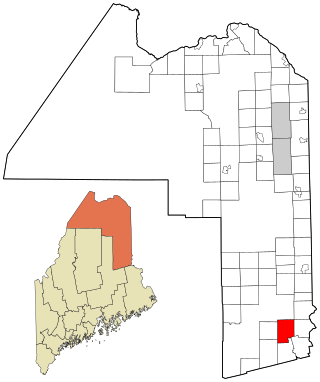
Haynesville is a town in Aroostook County, Maine, United States. The population was 97 at the 2020 census.

<span class="mw-page-title-main">St. Agatha, Maine</span> Town in the state of Maine, United States

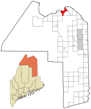
St. Agatha is a town in Aroostook County, Maine, United States. The population was 730 at the 2020 census.

Talmadge is a town in Washington County, Maine, United States. The town was named after landowner Benjamin Tallmadge. The population was 70 at the 2020 census.

Vanceboro is a town in Washington County, Maine, United States. The town was named after landowner William Vance. The main village in town is located at the eastern terminus of Maine State Route 6. Vanceboro is across the St. Croix River from St. Croix, New Brunswick, Canada, to which it is connected by the Saint Croix–Vanceboro Bridge. Vanceboro is also connected to St. Croix by the Saint Croix–Vanceboro Railway Bridge, which is used by the New Brunswick Southern Railway.

<span class="mw-page-title-main">Whitneyville, Maine</span> Town in the state of Maine, United States

Whitneyville is a town in Washington County, Maine, United States. The town was named after Colonel Joseph Whitney, a mill owner. The population was 202 at the 2020 census.

<span class="mw-page-title-main">St. Marys Point, Minnesota</span> City in Minnesota, United States

St. Marys Point or Saint Marys Point is a city in Washington County, Minnesota, United States. The population was 353 at the 2020 census.

<span class="mw-page-title-main">West Alton, Missouri</span> City in Missouri, United States

West Alton is a city in St. Charles County, Missouri, United States. The population was 359 at the 2020 census. It is located at the tip of the peninsula formed by the confluence of the Missouri and Mississippi Rivers and is directly across Alton, Illinois.

<span class="mw-page-title-main">Oak City, North Carolina</span> Town in North Carolina, United States

Oak City, formerly known as Goose Nest, is a town in Martin County, North Carolina, United States. The population was 266 at the 2020 census.

<span class="mw-page-title-main">Arthur, North Dakota</span> City in North Dakota, United States

Arthur is a city in Cass County, North Dakota, United States. The population was 328 at the 2020 census.

<span class="mw-page-title-main">Medina, North Dakota</span> City in North Dakota, United States

Medina is a city in Stutsman County, North Dakota, United States. The population was 264 at the 2020 census. Medina was founded in 1899.

<span class="mw-page-title-main">Pittsfield Township, Pennsylvania</span> Township in Pennsylvania, United States

Pittsfield Township is a township in Warren County, Pennsylvania, United States. The population was 1,283 at the 2020 census, down from 1,405 at the 2010 census. 1,519 at the 2000 census.

<span class="mw-page-title-main">Brunswick, Vermont</span> Town in Vermont, United States

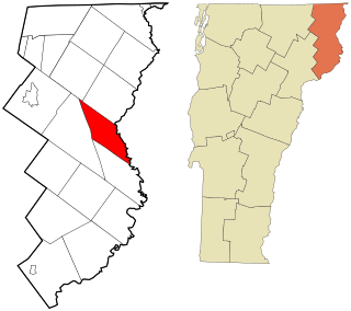
Brunswick is a town in Essex County, Vermont, United States. The town was named after Prince Karl Wilhelm Ferdinand of Brunswick-Lunenburg. The population was 88 at the 2020 census. It is part of the Berlin, NH-VT Micropolitan Statistical Area. Brunswick is home to six mineral springs that made the town a popular resort destination in the 19th century. The land the springs are on is now owned by the Abenaki people.

<span class="mw-page-title-main">Onley, Virginia</span> Town in Virginia, United States

Onley is a town in Accomack County, Virginia, United States. The population was 516 at the 2010 census.

<span class="mw-page-title-main">Durbin, West Virginia</span> Town in West Virginia, United States

Durbin is a town in Pocahontas County, West Virginia, United States. The population was 235 at the 2020 census.

<span class="mw-page-title-main">Dunn, Dunn County, Wisconsin</span> Town in Wisconsin, United States

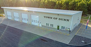
Dunn is a town in Dunn County, Wisconsin, United States. The population was 1,492 at the 2000 census. The unincorporated communities of Downsville and Dunnville are located in the town.

<span class="mw-page-title-main">East Millinocket, Maine</span> Town in the state of Maine, United States

East Millinocket is a town in Penobscot County, Maine, United States. The population was 1,572 at the 2020 census.

References

  1. "ArcGIS REST Services Directory". United States Census Bureau. Retrieved September 20, 2022.
  2. 1 2 U.S. Geological Survey Geographic Names Information System: Brunswick, North Carolina
  3. 1 2 "U.S. Census website". United States Census Bureau . Retrieved January 31, 2008.
  4. "Census of Population and Housing". Census.gov. Retrieved June 4, 2015.
  5. "Explore Census Data". data.census.gov. Retrieved December 22, 2021.