Brussels, Illinois

Last updated

Brussels
St Mary's Church, Brussels.jpg
St. Mary's Catholic Church, May 2014
Calhoun County Illinois Incorporated and Unincorporated areas Brussels Highlighted.svg
Location of Brussels in Calhoun County, Illinois.
Illinois in United States (US48).svg
Location of Illinois in the United States
Coordinates: 38°56′50″N90°35′19″W / 38.94722°N 90.58861°W / 38.94722; -90.58861
CountryUnited States
StateIllinois
County Calhoun
Area
[1]
  Total0.558 sq mi (1.45 km2)
  Land0.558 sq mi (1.45 km2)
  Water0.00 sq mi (0.0 km2)
Elevation
[2]
515 ft (157 m)
Population
 (2020)
  Total116
  Density210/sq mi (80/km2)
Time zone UTC-6 (CST)
  Summer (DST) UTC-5 (CDT)
Area code 618
FIPS code 17-09148
GNIS feature ID2397479 [2]
Wikimedia CommonsBrussels, Illinois

Brussels is a village in southern Calhoun County, Illinois, United States. The population was 116 at the 2020 census.

Contents

General information

Brussels is the headquarters location of the Two Rivers National Wildlife Refuge, which is noted for its population of bald eagles. The refuge is named after the two great rivers that flow together close to Brussels, the Illinois River and the Mississippi River.

Brussels has one school district, No. 42, which consists of one grade school (Brussels Grade School) and one high school (Brussels High School). The school district serves the surrounding communities of Meppen, Golden Eagle, and parts of Batchtown. In addition to the public school system, Brussels has a parochial grade school, St. Marys. Brussels High School is small and its enrollment usually hovers at around 70 students.

History

Brussels was first settled in 1822, when John Mettz came to the area; later in the same year, Joshua Twitchell established the community's first business, a blacksmith shop. In 1843, Brussels' population grew significantly due to an influx of German immigrants. German immigration continued through the 1860s, and Irish immigrants also began settling in Brussels in the 1850s. The Wittmond Trading Post, one of the first brick stores in the region, opened in Brussels in 1847, marking the beginning of the village's commercial development. St. Mary's Church formed in 1848 to serve the community's Catholic residents; its current church building was constructed in 1863. In the early 1860s, St. Matthew's Church formed for Brussels' German Lutheran population. Brussels opened its own post office in 1875 and built its own jail in 1876. In 1888, Brussels was legally incorporated as a village. [3]

The main street of the village is a historic district listed on the National Register of Historic Places.

Geography

Brussels is located at 38°56′50″N90°35′19″W / 38.94722°N 90.58861°W / 38.94722; -90.58861 (38.947275, -90.588630). [4]

According to the 2021 census gazetteer files, Brussels has a total area of 0.56 square miles (1.45 km2), all land. [1]

Historical population
CensusPop.Note
1890 228
1900 27018.4%
1910 2834.8%
1920 280−1.1%
1930 279−0.4%
1940 275−1.4%
1950 205−25.5%
1960 201−2.0%
1970 191−5.0%
1980 168−12.0%
1990 125−25.6%
2000 14112.8%
2010 1410.0%
2020 116−17.7%
U.S. Decennial Census [5]

Demographics

As of the 2020 census [6] there were 116 people, 36 households, and 17 families residing in the village. The population density was 207.89 inhabitants per square mile (80.27/km2). There were 55 housing units at an average density of 98.57 per square mile (38.06/km2). The racial makeup of the village was 93.97% White, 0.86% African American, 1.72% from other races, and 3.45% from two or more races. Hispanic or Latino of any race were 1.72% of the population.

There were 36 households, out of which 11.1% had children under the age of 18 living with them, 44.44% were married couples living together, 2.78% had a female householder with no husband present, and 52.78% were non-families. 52.78% of all households were made up of individuals, and 19.44% had someone living alone who was 65 years of age or older. The average household size was 4.47 and the average family size was 2.64.

The village's age distribution consisted of 9.7% under the age of 18, 6.2% from 18 to 24, 30.1% from 25 to 44, 34.5% from 45 to 64, and 19.5% who were 65 years of age or older. The median age was 48.5 years. For every 100 females, there were 63.8 males. For every 100 females age 18 and over, there were 56.9 males.

Males had a median income of $39,583 versus $19,844 for females. The per capita income for the village was $25,463. No families and 27.4% of the population were below the poverty line, including none of those under age 18 and 36.4% of those age 65 or over.

See also

Related Research Articles

<span class="mw-page-title-main">Philo, Illinois</span> Village in Illinois, United States

Philo is a village about nine miles south of Urbana in Champaign County, Illinois, United States. The population was 1,392 at the 2020 census.

<span class="mw-page-title-main">East Dundee, Illinois</span> Village in Illinois, United States

East Dundee is a village in Kane County with a small section in Cook County. The population was 3,152 at the 2020 census.

<span class="mw-page-title-main">Dunfermline, Illinois</span> Village in Illinois, United States

Dunfermline is a village in Fulton County, Illinois, United States. The population was 262 at the 2020 census. Dunfermline is pronounced Done-ferm-lin.

<span class="mw-page-title-main">Seneca, Illinois</span> Village in Illinois, United States

Seneca is a village in LaSalle and Grundy counties in the U.S. state of Illinois. The population was 2,353 at the 2020 census, down from 2,371 at the 2010 census.

<span class="mw-page-title-main">Elizabethtown, Illinois</span> Village in Illinois, United States

Elizabethtown is a village in and the county seat of Hardin County, Illinois, United States, along the Ohio River. The population was 299 at the 2010 census, down from 348 at the 2000 census. It is the least-populous county seat in the state.

<span class="mw-page-title-main">Hanover, Illinois</span> Village in Illinois, United States

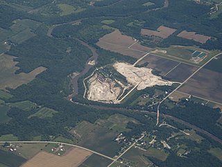
Hanover is a village in Jo Daviess County, Illinois, United States, along the Apple River. The town was previously named Wapello, in honor of Chief Wapello of the Meskwaki tribe. The population was 844 at the 2010 census, up from 836 in 2000.

<span class="mw-page-title-main">Menominee, Illinois</span> Village in Illinois, United States

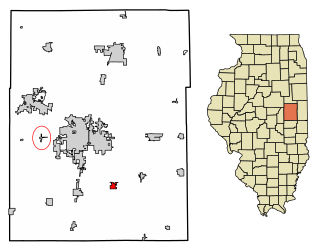
Menominee is a village in Jo Daviess County, Illinois, United States. The population was 248 at the 2010 census, up from 237 in 2000. The village is located on the Little Menominee River near East Dubuque and Galena.

<span class="mw-page-title-main">Ransom, Illinois</span> Village in Illinois, United States

Ransom is a village in LaSalle County, Illinois, United States. The population was 308 at the 2020 census, down from 384 at the 2010 census. It is part of the Ottawa Micropolitan Statistical Area. It is part of the subregion known as Streatorland.

<span class="mw-page-title-main">Tonica, Illinois</span> Village in LaSalle County, Illinois

Tonica is a village in LaSalle County, Illinois, United States. The population was 749 at the 2020 census, down from 768 at the 2010 census. It is part of the Ottawa Micropolitan Statistical Area.

<span class="mw-page-title-main">Hartford, Illinois</span> Village in Illinois, United States

Hartford is a village in Madison County, Illinois, United States, on the Mississippi River near the mouth of the Missouri River. The population was 1,185 at the 2020 census, down from 1,429 in 2010. Lewis and Clark spent the winter of 1803-04 there, near what has been designated the Lewis and Clark State Historic Site.

<span class="mw-page-title-main">Matherville, Illinois</span> Village in Illinois, United States

Matherville is a village in Mercer County, Illinois, United States. The population was 707 at the 2020 census.

<span class="mw-page-title-main">Maeystown, Illinois</span> Village in Illinois, United States

Maeystown is a village in Monroe County, Illinois, United States. The population was 150 at the 2020 census.

<span class="mw-page-title-main">Pleasant Hill, Illinois</span> Village in Illinois, United States

Pleasant Hill is a village in Pike County, Illinois, United States. The population was 966 at the 2010 census.

<span class="mw-page-title-main">Dupo, Illinois</span> Village in Illinois, United States

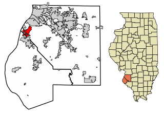
Dupo is a village in St. Clair County, Illinois, United States. The population was 4,138 at the 2010 census, an increase from 3,933 in 2000. The village was settled in about 1750 and was incorporated in 1907. Its modern name, adopted in the early 20th century, is shortened from Prairie du Pont.

<span class="mw-page-title-main">Fairview Heights, Illinois</span> City in Illinois, United States

Fairview Heights is a city in St. Clair County, Illinois, United States within Greater St. Louis. It is an eastern suburb of St. Louis. The population was 17,078 at the 2010 census. Fairview Heights is a dominant shopping center for Greater St. Louis and Southern Illinois and includes numerous shopping plazas and St. Clair Square mall.

<span class="mw-page-title-main">Sauget, Illinois</span> Village in Illinois, United States

Sauget is a village in St. Clair County, Illinois, United States. It is part of Greater St. Louis. The population was 141 at the 2020 census, down from 159 in 2010.

<span class="mw-page-title-main">Washington Park, Illinois</span> Village in Illinois, United States

Washington Park is a village in St. Clair County, Illinois, United States. The population was 2,592 as of the 2020 census, down from 4,196 in 2010.

<span class="mw-page-title-main">Okawville, Illinois</span> Village in Illinois, United States

Okawville is a village in Washington County, Illinois, United States. The population was 1,434 at the 2010 census.

<span class="mw-page-title-main">Toms Brook, Virginia</span> Town in Virginia, United States

Toms Brook is a town in Shenandoah County, Virginia, United States. The population was 258 at the 2010 census.

<span class="mw-page-title-main">Fairfield (CDP), Maine</span> CDP in Maine, United States

Fairfield is a census-designated place (CDP) in the town of Fairfield in Somerset County, Maine, United States. The population was 2,569 at the 2000 census.

References

  1. 1 2 Bureau, US Census. "Gazetteer Files". Census.gov. Retrieved June 29, 2022.
  2. 1 2 U.S. Geological Survey Geographic Names Information System: Brussels, Illinois
  3. Linn, Cindy (May 1, 1998). "National Register of Historic Places Registration Form: Brussels Historic District" (PDF). National Park Service. Archived from the original (PDF) on August 11, 2014. Retrieved August 9, 2014.
  4. "US Gazetteer files: 2010, 2000, and 1990". United States Census Bureau. February 12, 2011. Retrieved April 23, 2011.
  5. "Census of Population and Housing". Census.gov. Retrieved June 4, 2015.
  6. "Explore Census Data". data.census.gov. Retrieved June 28, 2022.

Commons-logo.svg Media related to Brussels, Illinois at Wikimedia Commons