
Flintshire is a county in the north-east of Wales. It borders England to the east, Denbighshire to the west and Wrexham County Borough to the south. It is named after the historic county of the same name which has notably different borders. Flintshire is considered part of the Welsh Marches and formed part of the historic Earldom of Chester and Flint. The county is governed by Flintshire County Council which has its main offices in County Hall, Mold.

Flint is a town and community in Flintshire, Wales, lying on the estuary of the River Dee. It is the former county town of Flintshire. According to the 2001 Census, the population of the community of Flint was 12,804, increasing to 12,953 at the 2011 census. The urban area including Holywell and Bagillt had a population of 26,442.

Holywell is a market town and community in Flintshire, Wales. It lies to the west of the estuary of the River Dee. The community includes Greenfield.
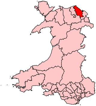
Delyn is a constituency represented in the House of Commons of the UK Parliament since 2019 by Rob Roberts, who was elected as a Conservative, but currently sits as an Independent following sexual harassment allegations.

Delyn was a local government district with borough status from 1974 to 1996, being one of six districts in the county of Clwyd, north-east Wales.

Caerwys is a town in Flintshire, Wales. It is just under two miles from the A55 North Wales Expressway and one mile from the A541 Mold-Denbigh road. At the 2001 Census, the population of Caerwys community was 1,315, with a total ward population of 2,496. Following reorganisation the community population fell at the 2011 Census to 1,283 with the ward raising to 2,569. The community includes Afonwen.
Bagillt is a market town and community in Flintshire, Wales. The town overlooks the Dee Estuary and is between the towns of Holywell and Flint. At the 2001 Census the population was recorded as 3,918, increasing to 4,165 at the 2011 census. The community also includes the villages of Walwen and Whelston. Landmark locations such as Gemma Rushes bath.

Northop is a village, community and electoral ward situated in Flintshire, Wales, approximately 12 miles west of the city of Chester, midway between Mold and Flint, and situated just off junction 33 of the A55 North Wales Expressway. At the 2001 Census, the population of Northop was 2,983, increasing to 3,049 at the 2011 census. The community includes Sychdyn.

Nannerch is a village and community in Flintshire, Wales, located within the Clwydian Range and Dee Valley Area of Outstanding Natural Beauty. At the 2001 Census the population of Nannerch was 531, reducing to 496 in 2011.

Langstone is a community and village of the city of Newport, Wales. The area is governed by the Newport City Council. The community had a population of 3,279 in 2011.

Cilcain is a village and community, near Mold in Flintshire, north-east Wales. The village has an industrial history and includes the Millennium Woods, a post office, a public house, a parish church, a primary school and a village hall.
Halkyn is a village and community in Flintshire, north-east Wales and situated between Pentre Halkyn, Northop and Rhosesmor. At the 2001 Census the population of the community was 2,876, increasing slightly to 2,879 at the 2011 Census. Pentre Halkyn is in the community.

Gwernymynydd is a village outside the market town of Mold in Flintshire, Wales. It forms part of the Gwernymynydd and Cadole community. At its highest point it is 1000 feet above sea level. It has two pubs and a once-busy garage, now a coach depot, home to Eagles & Crawford. Gwernymynydd is also home to a farm, a community centre, and a village primary school. Neighbouring communities include Gwernaffield, Llanferres, Nercwys, and Mold. The population at the 2011 census was 1,141.

Ysceifiog, also spelled as Ysgeifiog, is a village, community and parish in Flintshire, Wales. It lies on a back road just north of the A541 highway between Nannerch and Caerwys. The name translates roughly as "a place where elder trees grow".

Greenfield is a village in the community of Holywell, Flintshire, north-east Wales, on the edge of the River Dee estuary. At the time of the 2001 census it had a population of 2,741, which remained unchanged in the 2011 census.
Whitford is a village, community and an electoral ward near Holywell in Flintshire, northeast Wales. The population of both the community and the ward taken at the 2011 census was 2,332. The community includes the villages of Carmel, Lloc, Gorsedd and Pantasaph.
Holywell Golf Club is a golf club, situated a mile southwest of the town of Holywell, Flintshire, Wales. Instituted in 1906, it is an 18-hole moorland and parkland course and is approximately 800 feet above sea level. In 2001 the club nearly faced bankruptcy due to problems with Foot-and-mouth disease from roaming sheep.

St Michael's Church, also known as Brynford Parish Church, is a Grade II listed Church in Wales church in Brynford, Flintshire, northeast Wales, to the southwest of Holywell. The foundation stone was laid by the Bishop of St. Asaph on 6 October 1851, and it was consecrated on 12 July 1853. The architect was Thomas Henry Wyatt. It is designated as a Grade II listed building

Scleddau is a village and a community in the county of Pembrokeshire, Wales, and is 2 miles (3.2 km) south of Fishguard on the main A40 road. The Western Cleddau river which lends its name to the village flows under the main road. There are several springs in the village.


