Bunkie, Louisiana

Last updated

Bunkie, Louisiana
Motto: 
"The best place top side God's Green Earth" [1]
Avoyelles Parish Louisiana Incorporated and Unincorporated areas Bunkie Highlighted.svg
Location of Bunkie in Avoyelles Parish, Louisiana.
Louisiana in United States (US48).svg
Location of Louisiana in the United States
Coordinates: 30°57′13″N92°11′08″W / 30.95361°N 92.18556°W / 30.95361; -92.18556
CountryUnited States
StateLouisiana
Parish Avoyelles
Government
Area
[2]
  Total3.04 sq mi (7.87 km2)
  Land3.02 sq mi (7.83 km2)
  Water0.01 sq mi (0.04 km2)
Elevation
66 ft (20 m)
Population
 (2020)
  Total3,346
  Density1,107.21/sq mi (427.48/km2)
Time zone UTC-6 (CST)
  Summer (DST) UTC-5 (CDT)
Zip Code
71322
Area code 318
FIPS code 22-10950
Website bunkiecityhall.com

Bunkie is a city in Avoyelles Parish, Louisiana, United States. The population was 4,171 at the 2010 census. [3]

Contents

History

Bunkie was founded as a station terminus on the Texas and Pacific Railroad line. It was named for the daughter (whose nickname was "Bunkie") of the original landowner. [4]

The federal post office in town contains a mural, Cotton Pickers, painted in 1939 during the Great Depression by Caroline Speare Rohland. Federally commissioned murals were produced from 1934 to 1943 in the United States through the Section of Painting and Sculpture, later called the Section of Fine Arts, of the Treasury Department. This work was part of the effort by the federal government to employ artists during the difficult Depression years. [5]

The area around Bunkie is devoted to agriculture; since the late 20th century, corn has been an important commodity crop. Since 1987, Bunkie has hosted the annual Louisiana Corn Festival during the second full weekend of June. [6]

Geography

According to the United States Census Bureau, the city has a total area of 2.69 square miles (6.97 km2), of which 2.68 square miles (6.93 km2) is land and 0.015 square miles (0.04 km2), or 0.57%, is water. [3]

Climate

Climate data for Bunkie, Louisiana (1991–2020 normals, extremes 1956–present)
MonthJanFebMarAprMayJunJulAugSepOctNovDecYear
Record high °F (°C)81
(27)
85
(29)
88
(31)
93
(34)
99
(37)
102
(39)
103
(39)
107
(42)
106
(41)
98
(37)
89
(32)
83
(28)
107
(42)
Average high °F (°C)60.2
(15.7)
64.1
(17.8)
71.6
(22.0)
78.6
(25.9)
85.5
(29.7)
90.7
(32.6)
92.8
(33.8)
93.3
(34.1)
89.0
(31.7)
80.7
(27.1)
70.1
(21.2)
62.3
(16.8)
78.2
(25.7)
Daily mean °F (°C)49.7
(9.8)
53.4
(11.9)
60.4
(15.8)
67.3
(19.6)
74.9
(23.8)
80.5
(26.9)
82.8
(28.2)
82.5
(28.1)
77.7
(25.4)
68.1
(20.1)
58.1
(14.5)
51.7
(10.9)
67.3
(19.6)
Average low °F (°C)39.2
(4.0)
42.6
(5.9)
49.3
(9.6)
56.0
(13.3)
64.3
(17.9)
70.4
(21.3)
72.7
(22.6)
71.8
(22.1)
66.4
(19.1)
55.5
(13.1)
46.1
(7.8)
41.0
(5.0)
56.3
(13.5)
Record low °F (°C)10
(−12)
13
(−11)
23
(−5)
33
(1)
32
(0)
50
(10)
56
(13)
55
(13)
38
(3)
27
(−3)
22
(−6)
8
(−13)
8
(−13)
Average precipitation inches (mm)6.79
(172)
5.30
(135)
4.67
(119)
5.92
(150)
5.01
(127)
4.86
(123)
4.14
(105)
4.68
(119)
4.52
(115)
4.76
(121)
5.45
(138)
5.33
(135)
61.63
(1,565)
Average precipitation days (≥ 0.01 in)10.49.38.67.27.810.310.09.07.26.77.910.0104.4
Source: NOAA [7] [8]

Demographics

Historical population
CensusPop.Note
1890 299
1900 873192.0%
1910 1,765102.2%
1920 1,743−1.2%
1930 2,46441.4%
1940 3,57545.1%
1950 4,66630.5%
1960 5,18811.2%
1970 5,3954.0%
1980 5,364−0.6%
1990 5,044−6.0%
2000 4,662−7.6%
2010 4,171−10.5%
2020 3,346−19.8%
U.S. Decennial Census [9]

2020 census

Bunkie racial composition [10]
RaceNumberPercentage
White (non-Hispanic)1,07031.98%
Black or African American (non-Hispanic)2,04161.0%
Native American 90.27%
Asian 100.3%
Other/Mixed 1494.45%
Hispanic or Latino 672.0%

As of the 2020 United States census, there were 3,346 people, 1,702 households, and 1,227 families residing in the city.

2000 census

As of the census [11] of 2000, there were 4,662 people, 1,698 households, and 1,198 families residing in the city. The population density was 1,763.4 inhabitants per square mile (680.9/km2). There were 1,866 housing units at an average density of 705.8 per square mile (272.5/km2). The racial makeup of the city was 48.54% White, 50.26% African American, 0.04% Native American, 0.28% Asian, 0.34% from other races, and 0.54% from two or more races. Hispanic or Latino of any race were 1.48% of the population.

There were 1,698 households, out of which 35.2% had children under the age of 18 living with them, 39.4% were married couples living together, 26.6% had a female householder with no husband present, and 29.4% were non-families. 26.3% of all households were made up of individuals, and 11.8% had someone living alone who was 65 years of age or older. The average household size was 2.66 and the average family size was 3.22.

In the city, the population was spread out, with 30.3% under the age of 18, 9.1% from 18 to 24, 23.8% from 25 to 44, 20.6% from 45 to 64, and 16.2% who were 65 years of age or older. The median age was 35 years. For every 100 females, there were 82.5 males. For every 100 females age 18 and over, there were 73.2 males.

The median income for a household in the city was $14,745, and the median income for a family was $23,448. Males had a median income of $31,382 versus $19,479 for females. The per capita income for the city was $10,302. About 34.4% of families and 37.8% of the population were below the poverty line, including 38.9% of those under age 18 and 32.5% of those age 65 or over.

Notable people

Related Research Articles

<span class="mw-page-title-main">LaSalle Parish, Louisiana</span> Parish in Louisiana, United States

LaSalle Parish is a parish located in the U.S. state of Louisiana. As of the 2020 United States Census, the population was 14,791. The parish seat is Jena. The parish was created in 1910 from the western section of Catahoula Parish and named for René-Robert Cavelier, Sieur de La Salle.

<span class="mw-page-title-main">Avoyelles Parish, Louisiana</span> Parish in Louisiana, United States

Avoyelles is a parish located in central eastern Louisiana on the Red River where it effectively becomes the Atchafalaya River and meets the Mississippi River. As of the 2020 census, the population was 39,693. The parish seat is Marksville. The parish was created in 1807, with the name deriving from the French name for the historic Avoyel people, one of the local Indian tribes at the time of European encounter.

<span class="mw-page-title-main">Margaret, Alabama</span> City in Alabama, United States

Margaret is a city in St. Clair County, Alabama, United States. At the 2020 census, the population was 5,106. As of the 2010 census, the population is 4,428, an increase of 278.8%. Margaret incorporated in 1960 and became a city in October 2011.

<span class="mw-page-title-main">West Bradenton, Florida</span> Census-designated place in Florida, United States

West Bradenton is an unincorporated area and census-designated place (CDP) in Manatee County, Florida, United States. The population was 4,247 at the 2020 census. It is part of the Bradenton–Sarasota–Venice Metropolitan Statistical Area.

<span class="mw-page-title-main">Chattanooga Valley, Georgia</span> CDP in Georgia, United States

Chattanooga Valley is a census-designated place (CDP) in Walker County, Georgia, United States. The population was 3,962 at the 2020 census. It is part of the Chattanooga, TN–GA Metropolitan Statistical Area.

<span class="mw-page-title-main">Cottonport, Louisiana</span> Town in Louisiana, United States

Cottonport is a town in Avoyelles Parish, Louisiana, United States. The population was 2,006 at the 2010 census.

<span class="mw-page-title-main">Evergreen, Louisiana</span> Town in Louisiana, United States

Evergreen is a town in Avoyelles Parish, Louisiana, United States. The population was 310 at the 2010 census. Evergreen is located east of Bunkie.

<span class="mw-page-title-main">Hessmer, Louisiana</span> Village in Louisiana, United States

Hessmer is a village in Avoyelles Parish, Louisiana, United States. The population was 802 at the 2010 census.

<span class="mw-page-title-main">Marksville, Louisiana</span> City in Louisiana, United States

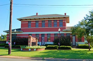
Marksville is a small city in and the parish seat of Avoyelles Parish, Louisiana, United States. The population was 5,702 at the 2010 census, an increase of 165 over the 2000 tabulation of 5,537.

<span class="mw-page-title-main">Moreauville, Louisiana</span> Village in Louisiana, United States

Moreauville is a village in Avoyelles Parish, Louisiana, United States. The population was 929 at the 2010 census.

<span class="mw-page-title-main">Plaucheville, Louisiana</span> Village in Louisiana, United States

Plaucheville is a village in Avoyelles Parish, Louisiana, United States. The population was 248 at the 2010 census.

<span class="mw-page-title-main">Simmesport, Louisiana</span> Town in Louisiana, United States

Simmesport is a town in Avoyelles Parish, Louisiana, United States. The population was 2,161 at the 2010 census. It is the northernmost town on the Atchafalaya River, located near the Old River which connects the Red and Atchafalaya rivers with the Mississippi River.

<span class="mw-page-title-main">Oil City, Louisiana</span> Town in Louisiana, United States

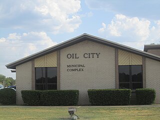
Oil City is a town in Caddo Parish, Louisiana. The population was 1,008 at the time of the 2010 census. Oil City is located on Louisiana Highway 1, north of Caddo Lake. It is part of the Shreveport–Bossier City Metropolitan Statistical Area.

<span class="mw-page-title-main">Cheneyville, Louisiana</span> Town in Louisiana, United States

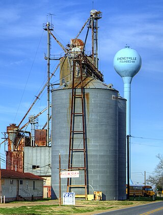
Cheneyville is a town in Rapides Parish, Louisiana, United States. It is part of the Alexandria, Louisiana Metropolitan Statistical Area. The population was 625 at the 2010 census.

<span class="mw-page-title-main">Gramercy, Louisiana</span> Town in Louisiana, United States

Gramercy is a town in the U.S. state of Louisiana, in St. James Parish. It is part of the New Orleans Metropolitan Area. The population was 3,613 at the time of the 2010 U.S. census and 3,188 according to the 2020 population estimates program.

Amelia is a census-designated place (CDP) in St. Mary Parish, Louisiana, United States. The population was 2,459 at the 2010 census. It is part of the Morgan City Micropolitan Statistical Area.

<span class="mw-page-title-main">Tangipahoa, Louisiana</span> Village in Louisiana

Tangipahoa is a village in Tangipahoa Parish, Louisiana, United States. The population was 425 at the 2020 census. It was named after the Tangipahoa Native American tribe. Tangipahoa is part of the Hammond Micropolitan Statistical Area.

Wyanett Township is a township in Isanti County, Minnesota, United States. The population was 1,698 at the 2000 census.

<span class="mw-page-title-main">Corning, Missouri</span> Village in Missouri, United States

Corning is a village in Holt County, Missouri, United States. The population was 3 at the 2020 census.

<span class="mw-page-title-main">LeBoeuf Township, Pennsylvania</span> Township in Pennsylvania, United States

LeBoeuf Township is a township in Erie County, Pennsylvania, United States. The population was 1,657 at the 2020 census, down from 1,698 at the 2010 census.

References

  1. "City of Bunkie, Louisiana". City of Bunkie, Louisiana. Archived from the original on November 27, 2012. Retrieved August 26, 2012.
  2. "2020 U.S. Gazetteer Files". United States Census Bureau. Retrieved March 20, 2022.
  3. 1 2 "Geographic Identifiers: 2010 Demographic Profile Data (G001): Bunkie city, Louisiana". U.S. Census Bureau, American Factfinder. Archived from the original on February 12, 2020. Retrieved May 16, 2013.
  4. Leeper, Clare D'Artois (October 19, 2012). Louisiana Place Names: Popular, Unusual, and Forgotten Stories of Towns, Cities, Plantations, Bayous, and Even Some Cemeteries. LSU Press. p. 47. ISBN   978-0-8071-4740-5.
  5. Arnesen, Eric (2007). Encyclopedia of U.S. Labor and Working-Class History. Vol. 1. New York: Routledge. p. 1540. ISBN   9780415968263.
  6. Louisiana Corn Festival
  7. "NowData - NOAA Online Weather Data". National Oceanic and Atmospheric Administration. Retrieved August 27, 2021.
  8. "Station: Bunkie, LA". U.S. Climate Normals 2020: U.S. Monthly Climate Normals (1991-2020). National Oceanic and Atmospheric Administration. Retrieved August 27, 2021.
  9. "Census of Population and Housing". Census.gov. Retrieved June 4, 2015.
  10. "Explore Census Data". data.census.gov. Retrieved December 29, 2021.
  11. "U.S. Census website". United States Census Bureau . Retrieved January 31, 2008.
  12. "Obituary of Sue Lyles Eakin". melanconfunerals.com. Retrieved September 21, 2009.
  13. "Donald Hines' Biography". votesmart.org. Retrieved October 16, 2013.
  14. "Seymour Weiss Papers" (PDF). Louisiana State University Libraries. Retrieved October 19, 2021.