Burley, Hampshire

Last updated

Burley
Burley, looking along Ringwood Road - geograph.org.uk - 177394.jpg
Burley, village centre
Hampshire UK location map.svg
Red pog.svg
Burley
Location within Hampshire
Population1,350  [1]
1,384 (2011 Census including Picket Post) [2]
OS grid reference SU2123003124
District
Shire county
Region
Country England
Sovereign state United Kingdom
Post town RINGWOOD
Postcode district BH24
Dialling code 01425
Police Hampshire and Isle of Wight
Fire Hampshire and Isle of Wight
Ambulance South Central
UK Parliament
Website Burley village
List of places
UK
England
Hampshire
50°49′38″N1°42′00″W / 50.827271°N 1.699937°W / 50.827271; -1.699937 Coordinates: 50°49′38″N1°42′00″W / 50.827271°N 1.699937°W / 50.827271; -1.699937

Burley is a village and civil parish in the New Forest, Hampshire, England. It has ancient origins and is now somewhat tourist-orientated.

Contents

The village

Burley is located towards the western edge of the New Forest, 4 miles (6 km) south-east of the town of Ringwood. [3] The village is fairly scattered, and apart from the village centre, there is Burley Street to the north; Bisterne Close to the east; and the Mill Lawn area to the north-east. [4] Burley has a post office, newsagents, butcher's shop, and village stores, as well as tea rooms, a Hippy/festival clothing shop, antique shops, art galleries and gift shops, pubs and a large Cycle Shop and Cycle Hire centre. [3] The village still practises the old tradition of commoning, allowing animals to graze on the open Forest, and ponies and cattle roam freely around the village. [5] Burley is home to a football club [6] and a cricket club. [7] Burley Golf Club can be found to the southeast of the village. [8]

The village is surrounded by the open heathland of the New Forest, [9] containing a complex of woodland, heathland and acid grassland, shrub and valley bog, supporting a richness and diversity of wildlife. [10] Burley is twinned with Beurlay, Charente-Maritime, France. Burley Fire Station is thought to be the only fire station in the country with a cattle grid at the entrance.

History

People have lived in the Burley area since prehistoric times. At least 23 Bronze Age barrows are known in the Burley area. [11] The site of an Iron Age hillfort can be seen just to the west of the village at Castle Hill. [12]

There is evidence of Saxon occupation as the name Burley is composed of two Saxon words 'burgh', which means fortified palace, and 'leah', which means an open meadow or clearing in a wood. [13]

Burley is not specifically mentioned in the Domesday book of 1086, but the entry for nearby Ringwood may well refer to Burley when it mentions lands in the forest with "14 villagers and 6 smallholders with 7 ploughs; a mill at 30d; and woodland at 189 pigs from pasturage." [14]

Burley was part of the royal lands of the New Forest. [15] By the beginning of the 13th century the family of de Burley was firmly established here. [13] Richard de Burley held the estate from Edward I who gave the village of Burley and Manor of Lyndhurst as dowry to his second wife Margaret, sister of Philip IV of France. [13] The manor is said to have belonged to the Crown down to the time of James I. [15]

There was a watermill belonging to the manor of Burley, [15] which ceased operating around 1820. [16] The mill is commemorated in names of Mill Lawn and Mill Lawn Brook, [15] but the only building which survives is the grist house in the grounds of Mill Cottage. [16]

The first known church in Burley was the Calvinistic Burley Chapel erected in 1789. [13] The ecclesiastical parish of Burley was formed in 1840 out of Ringwood., [15] this was served by the Anglican church of John the Baptist which was built in 1839 and added to in 1886–7. [15] A school was built in Burley in 1854 large enough to accommodate 120 children. [15]

In 1852 the manor passed into the possession of Colonel Esdaile who pulled down the old manor house and built a new one. [13] Further changes to the building have been made since that time, and the manor house is now a hotel. [13]

2 miles (3 km) to the north-east of the Burley village lies Burley Lodge, whose history dates back to the 15th century. It was part of the lands of the "bailiwick of Burley" which was held in the 18th century by the Paulets, Dukes of Bolton and Marquesses of Winchester. [15]

The civil parish of Burley was formed in 1868 from Burley Walk and Holmsley Walk, extra-parochial parts of the New Forest, together with the ancient vill of Burley. [15] From 1847 to 1964, Burley was served by trains at nearby Holmsley railway station, about 1.5 miles (2.4 km) southeast of the village. [17] The station buildings still stand, and are now tea rooms.

Arthur Clough (son of Arthur Hugh Clough) and his wife Eleanor Freshfield built Castletop House on Castle Hill Lane in 1898: Eleanor's father was President of the Royal Geographic Society and brought back many exotic plants from his travels which were planted at Castletop.

Burley has a long connection with witches; in the late 1950s, Sybil Leek, a self-styled white witch, lived in the village. [13] She could be seen walking around Burley with her pet jackdaw on her shoulder before she moved to America. [18] Some of the gift shops in Burley now sell witch-related gifts and ornaments. [13]

Burley was also once a favourite haunt for smugglers, and a secret cellar in the Queens Head pub was discovered during renovation work, where pistols, coins, and other unusual items were discovered. [9]

The Bisterne Dragon

Burley is notable in English folklore for the supposed location of a dragon's lair at Burley Beacon, just outside the village. [19] There are several versions of the tale, one being that the creature "flew" every morning to Bisterne, where it would be supplied with milk. To kill the dragon, a valiant knight (usually named Berkeley) built a hide, and with two dogs lay in wait. The creature came as usual one morning for its milk, and when the hut door was opened the dogs attacked it, and while thus engaged the knight took the dragon by surprise, the dogs dying in the affray. [19] The fight raged throughout the forest, with the dragon finally dying outside Lyndhurst, its corpse turning into a great hill (now known as Boltons Bench). Though the knight had defeated the dragon he had been mentally broken by the battle, and after thirty days and thirty nights he went back to Boltons Bench to die alone atop it, his body turning into the yew tree which can still be seen today. [20]

Related Research Articles

<span class="mw-page-title-main">Brockenhurst</span> Human settlement in England

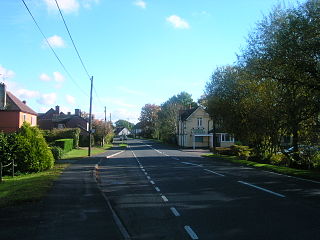
Brockenhurst is the largest village by population within the New Forest in Hampshire, England. The nearest city is Southampton some 13 miles (21 km) to the north-east, while Bournemouth is also nearby, 15 miles (24 km) south-west. Surrounding towns and villages include Beaulieu, Lymington, Lyndhurst, and Sway.

<span class="mw-page-title-main">Lyndhurst, Hampshire</span> Human settlement in England

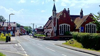
Lyndhurst is a large village and civil parish situated in the New Forest National Park in Hampshire, England. Serving as the administrative capital of the New Forest, it is a popular tourist attraction, with many independent shops, art galleries, cafés, museums, pubs and hotels. The nearest city is Southampton, about nine miles (14 km) to the north-east. As of 2001 Lyndhurst had a population of 2,973, increasing to 3,029 at the 2011 Census. The name derives from an Old English name, comprising the words lind and hyrst.

<span class="mw-page-title-main">Holbury</span> Human settlement in England

Holbury is a village in Hampshire, England. It is part of the parish of Fawley.

<span class="mw-page-title-main">Cadnam</span> Human settlement in England

Cadnam is a village situated in Hampshire, England, within the boundaries of the New Forest National Park. The village has existed since the medieval period, when it was an important crossroads between Southampton and the towns of Dorset.

<span class="mw-page-title-main">Hordle</span> Human settlement in England

Hordle is a village and civil parish in the county of Hampshire, England. It is situated between the Solent coast and the New Forest, and is bordered by the towns of Lymington and New Milton. Like many New Forest parishes Hordle has no village centre. The civil parish includes the hamlets of Tiptoe and Everton as well as part of Downton. The parish was originally much larger; stretching from the New Forest boundary to Hurst Castle.

<span class="mw-page-title-main">Minstead</span> Human settlement in England

Minstead is a small village and civil parish in the New Forest, Hampshire, about 2 miles (3.2 km) north of Lyndhurst. There is a shop and a pub, the Trusty Servant. Sir Arthur Conan Doyle's grave is under a large tree at the back of the 13th century All Saints' church.

Sybil Leek was an English witch, astrologer, occult author and self-proclaimed psychic. She wrote many books on occult and esoteric subjects, and was dubbed "Britain's most famous witch" by the BBC.

<span class="mw-page-title-main">Damerham</span> Human settlement in England

Damerham is a rural village and civil parish in the New Forest district of Hampshire, England, near Fordingbridge. The area has notable Neolithic and Bronze Age barrows. It was the site of an Anglo-Saxon religious community, mentioned in the will of Alfred the Great. By the time of Domesday Book (1086), Damerham was a major settlement in the possession of Glastonbury Abbey. The village has a riverside mill and a Norman church.

<span class="mw-page-title-main">Martin, Hampshire</span> Human settlement in England

Martin is a village and civil parish in the New Forest district of Hampshire, England. The nearest town, Fordingbridge, is 7 miles (11 km) to the south-east, and the cathedral city of Salisbury is 12 miles (19 km) to the north-east.

<span class="mw-page-title-main">Hale, Hampshire</span> Human settlement in England

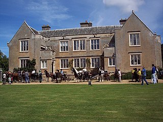
Hale is a small village and civil parish in Hampshire, England. It lies on the border of the New Forest, overlooking the valley of the River Avon. The village is about 3.5 miles (5.6 km) north-east of the town of Fordingbridge, and about 8 miles (13 km) south of the city of Salisbury. Within the parish stands Hale House, a large 18th-century mansion which was the country house of architect Thomas Archer, who also rebuilt Hale church in 1717.

<span class="mw-page-title-main">Pennington, Hampshire</span> Human settlement in England

Pennington is a ward in the New Forest district of Hampshire, England, which is defined based on the boundaries of the earlier manor. Pennington Village is at the centre of the ward, with Upper Pennington to the north and Lower Pennington to the south. The population taken at the 2011 census was 6,060. It is in the southernmost part of the New Forest on the Solent coastline near to the town of Lymington, with which it shares the civil parish of Lymington and Pennington.

<span class="mw-page-title-main">Ellingham, Hampshire</span> Human settlement in England

Ellingham is a small village near Ringwood in Hampshire, England, west of the New Forest National Park. It is in the civil parish of Ellingham, Harbridge and Ibsley. Ellingham is most famous for the story of Alice Lisle, who was executed by the infamous Judge Jeffreys in 1685, on the charge of harbouring fugitives after the defeat of the Monmouth Rebellion.

<span class="mw-page-title-main">Ibsley</span> Human settlement in England

Ibsley is a village in Hampshire, England. It is about 2.5 miles (4 km) north of the town of Ringwood. It is in the civil parish of Ellingham, Harbridge and Ibsley.

<span class="mw-page-title-main">Harbridge</span> Human settlement in England

Harbridge is a small village located some four kilometres north of Ringwood and a similar distance south of Fordingbridge, in southwest Hampshire, England. It is in the civil parish of Ellingham, Harbridge and Ibsley.

<span class="mw-page-title-main">Bank, Hampshire</span> Human settlement in England

Bank is a village in the English county of Hampshire. The settlement is within the civil parish of Lyndhurst in the New Forest, and is located approximately 8 miles (13 km) from both Ringwood and Southampton. It has one inn and approximately 30 distinct dwellings.

<span class="mw-page-title-main">Netley Marsh</span> Human settlement in England

Netley Marsh is a village and civil parish in Hampshire, close to the town of Totton. It lies within the New Forest District, and the New Forest National Park. It is the alleged site of the battle between an invading Anglo Saxon army, under Cerdic and a British army under Natanleod in the year 508.

<span class="mw-page-title-main">Bisterne</span> Human settlement in England

Bisterne is a hamlet in the civil parish of Ringwood in the New Forest National Park in Hampshire, England. Its nearest town is Ringwood, which lies 3 miles (4.8 km) to the north.

<span class="mw-page-title-main">Crow, Hampshire</span> Human settlement in England

Crow is a small village situated in the New Forest National Park in Hampshire, England. Its nearest town is Ringwood, which lies approximately 1 mile (1.6 km) north-west from the village.

<span class="mw-page-title-main">Emery Down</span> Human settlement in England

Emery Down is a small village in the New Forest National Park in Hampshire, England. Its nearest town is Lyndhurst, which lies approximately 1.4 miles (2.3 km) south-east from the village.

The Bisterne Dragon is a legend from the New Forest in England. The story takes place primarily in Bisterne, but also features Burley and Lyndhurst, and is one of the area's most famous pieces of folklore.

References

  1. Burley CP, 2001 Census Archived 11 October 2016 at the Wayback Machine – Office for National Statistics
  2. "Civil Parish population 2011". Neighbourhood Statistics. Office for National Statistics. Retrieved 11 December 2016.
  3. 1 2 Burley Archived 10 May 2013 at the Wayback Machine , New Forest Explorers Guide
  4. Burley Parish Council Archived 4 October 2016 at the Wayback Machine
  5. Burley Village Website Archived 21 October 2016 at the Wayback Machine
  6. BURLEY FC Archived 29 March 2010 at the Wayback Machine
  7. Burley Cricket Club
  8. Burley Golf Club Archived 14 October 2016 at the Wayback Machine
  9. 1 2 Burley Archived 10 August 2016 at the Wayback Machine , New Forest National Park
  10. Hampshire Treasures, Volume 5 (New Forest), Burley, page 56 Archived 31 May 2012 at the Wayback Machine
  11. Hampshire Treasures, Volume 5 (New Forest), Burley, page 57 Archived 4 March 2016 at the Wayback Machine , page 58 Archived 4 March 2016 at the Wayback Machine , page 59 Archived 4 March 2016 at the Wayback Machine
  12. Castle Hill (Hampshire) Archived 4 March 2016 at the Wayback Machine , The Megalithic Portal
  13. 1 2 3 4 5 6 7 8 Burley history, New Forest Online Archived 3 March 2016 at the Wayback Machine
  14. Burley History Archived 10 May 2013 at the Wayback Machine , New Forest Explorers Guide
  15. 1 2 3 4 5 6 7 8 9 Victoria County History, (1912), A History of the County of Hampshire: Volume 5, Pages 606–614 Archived 14 December 2013 at the Wayback Machine
  16. 1 2 Hampshire Treasures, Volume 5 (New Forest), Burley, page 61 Archived 31 May 2012 at the Wayback Machine
  17. Hampshire Treasures, Volume 5 (New Forest), Burley, page 64 Archived 31 May 2012 at the Wayback Machine
  18. Broomsticks in Burley Archived 14 July 2013 at the Wayback Machine , BBC Southampton, Tuesday, 29 October 2002
  19. 1 2 John Henry Blunt, (1877), Dursley and its neighbourhood; being historical memorials of Dursley Archived 11 August 2016 at the Wayback Machine , pages 124–6
  20. Reeve, Richard. New Forest Hauntings Archived 12 October 2016 at the Wayback Machine , Historic-UK, 2016