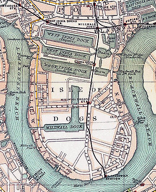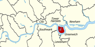
The Isle of Dogs is a large peninsula bounded on three sides by a large meander in the River Thames in East London, England, which includes the Cubitt Town, Millwall and Canary Wharf districts. The area was historically part of the Manor, Hamlet, Parish and, for a time, the wider borough of Poplar. The name had no official status until the 1987 creation of the Isle of Dogs Neighbourhood by Tower Hamlets London Borough Council. It has been known locally as simply "the Island" since the 19th century.
Limehouse is a district in the London Borough of Tower Hamlets in East London. It is 3.9 miles (6.3 km) east of Charing Cross, on the northern bank of the River Thames. Its proximity to the river has given it a strong maritime character, which it retains through its riverside public houses and steps, such as The Grapes and Limehouse Stairs. It is part of the traditional county of Middlesex. It became part of the ceremonial County of London following the passing of the Local Government Act 1888, and then part of Greater London in 1965. It is located between Stepney to the west and north, Mile End and Bow to the northwest, Poplar to the east, and Canary Wharf and Millwall to the south, and stretches from the end of Cable Street and Butcher Row in the west to Stainsby Road near Bartlett Park in the east, and from West India Dock and the River Thames in the south to Salmon Lane and Rhodeswell Road in the north.

Poplar is a district in East London, England, now part of the London Borough of Tower Hamlets. Five miles (8 km) east of Charing Cross, it is part of the East End.

Canary Wharf is an area of East London, England, located near the Isle of Dogs in the London Borough of Tower Hamlets. Canary Wharf is defined by the Greater London Authority as being part of London's central business district, alongside Central London. Alongside the City of London, it constitutes one of the main financial centres in the United Kingdom and the world, containing many high-rise buildings including the third-tallest in the UK, One Canada Square, which opened on 26 August 1991.

The West India Docks are a series of three docks, quaysides and warehouses built to import goods from and export goods and occasionally passengers to the British West Indies on the Isle of Dogs in London the first of which opened in 1802. Following their commercial closure in 1980, the Canary Wharf development was built around the wet docks by narrowing some of their broadest tracts.

Blackwall is an area of Poplar, in the London Borough of Tower Hamlets, East London. The neighbourhood includes Leamouth and the Coldharbour conservation area.

Millwall is a district on the western and southern side of the Isle of Dogs, in east London, England, in the London Borough of Tower Hamlets. It lies to the immediate south of Canary Wharf and Limehouse, north of Greenwich and Deptford, east of Rotherhithe, west of Cubitt Town, and has a long shoreline along London's Tideway, part of the River Thames. It was part of the County of Middlesex and from 1889 the County of London following the passing of the Local Government Act 1888, it later became part of Greater London in 1965.
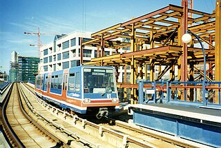
The London Docklands Development Corporation (LDDC) was a quango agency set up by the UK Government in 1981 to regenerate the depressed Docklands area of east London. During its seventeen-year existence it was responsible for regenerating an area of 8.5 square miles (22 km2) in the London Boroughs of Newham, Tower Hamlets and Southwark. LDDC helped to create Canary Wharf, Surrey Quays shopping centre, London City Airport, ExCeL Exhibition Centre, London Arena and the Docklands Light Railway, bringing more than 120,000 new jobs to the Docklands and making the area highly sought after for housing. Although initially fiercely resisted by local councils and residents, today it is generally regarded as having been a success and is now used as an exemplar of large-scale regeneration, although tensions between older and more recent residents remain.

Narrow Street is a narrow road running parallel to the River Thames through the Limehouse area of east London, England. It used to be much narrower, and is the oldest part of Limehouse, with many buildings originating from the eighteenth century.

Crossharbour is a light metro station on the Docklands Light Railway (DLR) Bank-Lewisham Line in Cubitt Town, East London. The station is situated on the Isle of Dogs and is between Mudchute and South Quay stations and is in Travelcard Zone 2.

Cubitt Town is a district on the eastern side of the Isle of Dogs in London, England. This part of the former Metropolitan Borough of Poplar was redeveloped as part of the Port of London in the 1840s and 1850s by William Cubitt, Lord Mayor of London (1860–1862), after whom it is named. It is on the east of the Isle, facing the Royal Borough of Greenwich across the River Thames. To the west is Millwall, to the east and south is Greenwich, to the northwest Canary Wharf, and to the north — across the Blue Bridge — is Blackwall. The district is situated within the Blackwall & Cubitt Town Ward of Tower Hamlets London Borough Council.

South Quay is a Docklands Light Railway (DLR) station on the Isle of Dogs, East London, England. The station is between Crossharbour and Heron Quays stations and is in Travelcard Zone 2. South Quay is in Millwall and is located on the southern shore of the South Dock of the West India Docks; the current station platforms sit astride the channel connecting Millwall Dock to the West India Docks.
Millwall Dock is a dock at Millwall, London, England, located south of Canary Wharf on the Isle of Dogs.

Mudchute Park and Farm is a large urban park and farm in Cubitt Town on the Isle of Dogs in the London Borough of Tower Hamlets, just south of Canary Wharf. It is a Local Nature Reserve and a Site of Metropolitan Importance for Nature Conservation.

London Buses route 277 is a Transport for London contracted bus route in London, England. Running between Crossharbour and Dalston Junction, it is operated by Stagecoach London.
The A1206, also known as the Isle of Dogs Distributor Road, is a crescent-shaped ring road around the Isle of Dogs, in the East End of London. It is made up of Westferry Road, Manchester Road and Prestons Road and is the main road through the area, connecting parts of the London Docklands.
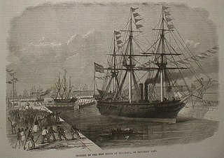
The Millwall Iron Works, London, England, was a 19th-century industrial complex and series of companies, which developed from 1824. Formed from a series of small shipbuilding companies to address the need to build larger and larger ships, the holding company collapsed after the Panic of 1866 which greatly reduced shipbuilding in London. Subsequently, a recovery was made by a series of smaller companies, but by the later 19th century the location was too small for the building of ships on the scale then required. Most of its buildings, being near the apex of the peninsula in the Isle of Dogs, survived the Blitz and have been made into apartment blocks in a residential estate, Burrells Wharf.

Coldharbour is a street and wider conservation area in Blackwall, lying on the north bank of the River Thames, east of Canary Wharf. The area is said to be "[t]he sole remaining fragment of the old hamlet of Blackwall" and "one of the last examples of the narrow streets which once characterised the river's perimeter".

Cascades Tower is a 20-storey residential building and a distinctive local landmark on the Isle of Dogs in East London. It was designed by Rex Wilkinson, a partner in the celebrated architectural firm CZWG, and built in 1987–88.