Nigeria is a country in West Africa. It shares land borders with the Republic of Benin to the west, Chad and Cameroon to the east, and Niger to the north. Its coast lies on the Gulf of Guinea in the south and it borders Lake Chad to the northeast. Notable geographical features in Nigeria include the Adamawa Plateau, Mambilla Plateau, Jos Plateau, Obudu Plateau, the Niger River, Benue River, and Niger Delta.
The city of Warri is an oil hub within South-South Nigeria and houses an annex of the Delta State Government House. Warri City is one of the major hubs of the petroleum industry in Nigeria. Warri, Udu, Okpe and Uvwie are the commercial capital of Delta State with a population of over 311,970 people in 2006. The city is the indigenous territory of Itsekiri, Urhobo and Ijaw people.

The Ijaw people, otherwise known as the Ijo people, are an ethnic group found in the Niger Delta in Nigeria, with significant population clusters in Bayelsa, Delta, and Rivers. They also occupy Edo, Ondo, and small parts of Akwa Ibom. Many are found as migrant fishermen in camps as far west as Sierra Leone and as far east as Gabon. They account for about 1.8% of the Nigerian population according to CIA Factbook. The Ijaws are one of the most populous tribes inhabiting the Niger Delta region and the eighth largest ethnic group in Nigeria.
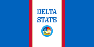
Delta State is a state in the South-South geopolitical zone of Nigeria. Named after the Niger Delta—a large part of which is in the state—the state was formed from the former Bendel State on August 27, 1991. Bordered on the north by Edo State, the east by Anambra and Rivers States, and the south by Bayelsa State, while to the west is the Bight of Benin which covers about 160 kilometres of the state's coastline. The State was initially created with 12 local government areas in 1991 which was later extended to 19 and now has 25 local government areas. Asaba as its state capital is located along the River Niger on the northeastern end of the State, while the state's economic centre is the twin cities of Warri and Uvwie.

The Escravos River is a river in southern Nigeria, close to the city of Warri. "Escravos" is a Portuguese word meaning "slaves" and the area was one of the main conduits for slave trade between Nigeria and the United States in the 18th century. The Escravos is a distributary of the Niger River, it flows for 57 kilometres (35 mi), ending at the Bight of Benin of the Gulf of Guinea where it flows into the Atlantic Ocean. Chevron, a major US oil company, has its main Nigerian oil production facility at the mouth of the Escravos River. This oil terminal pumps approximately.
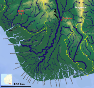
The Forçados River is a channel in the Niger Delta, in southern Nigeria. It flows for approximately 198 kilometres (123 mi) and meets the sea at the Bight of Benin in Delta State. It is an important channel for small ships. The Forçados River splits from the Niger River at Toru-Abubou near Agbere Town in Sagbama Local Government Area of Bayelsa State, the same point as the Nun River.

The Nun River, also known as Rio Nun, is a river in Bayelsa State, Nigeria. The river is formed when the Niger River splits into two at Toru-Abubou, near Agbere Town in Sagbama Local Government Area of Bayelsa State, forming the Nun and the Forcados rivers.
Bayelsa is a state in the South South region of Nigeria, located in the core of the Niger Delta. Bayelsa State was created in 1996 and was carved out from Rivers State, making it one of the newest states in the federation. The capital, Yenagoa, is susceptible to high risk of annual flooding. It shares a boundary with Rivers State to the east and Delta State to the north across the Niger River for 17 km and the Forçados River for 198 km, with the waters of the Atlantic Ocean dominating its southern borders. It has a total area of 10,773 square kilometres (4,159 sq mi). The state comprises eight local government areas: Ekeremor, Kolokuma/Opokuma, Yenagoa, Nembe, Ogbia, Sagbama, Brass and Southern Ijaw. The state is the smallest in Nigeria by population as of the 2006 census. Being in the Niger Delta, Bayelsa State has a riverine and estuarine setting, with bodies of water within the state preventing the development of significant road infrastructure.
Kontagora is a major town on the south bank of the Kontagora River in north-west Niger State, Nigeria. It is the capital city of the Kontagora Emirate. The former Niger state governor, Alhaji Abubakar Sani Bello hails from Kontagora. On December 15, 1995, the Roman Catholic Apostolic Vicariate of Kontagora was established here. St Michael's Cathedral is the seat of the apostolic vicar.
The United Africa Company of Nigeria is a Nigerian publicly listed company based in Lagos. Its areas of operation include manufacturing, services, logistics and warehousing, agricultural and real estate. UACN's food operations include UAC Franchising, UAC Restaurants and UAC Dairies. It also has equity stake in UACN Property Development Company, a quoted firm, CAP Plc, makers of Dulux paints and Portland Paints, manufacturers of Sandtex paints.
Suleja is a city in Niger State, Nigeria, pop. (2016) local government area, 260,240, just north of Abuja, capital of the Suleja Emirate. It is sometimes confused with the nearby city of Abuja, due to its proximity, and the fact that it was originally called Abuja before the Nigerian government adopted the name from the then Emir Sulayman Bal for its new federal capital in 1976.
Sapele is a primary town and one of the Local Government Areas of Delta State, Nigeria.

Bonny River is a river in Rivers State, Nigeria. Water taxis that move along the river provide the connection between Bonny Island and Port Harcourt, the capital of Rivers State, which lies alongside the river. It is also an arm of the Niger River delta. Shellfish such as prawns, periwinkle and crabs found in Bonny rivers have been discovered to contain high metals. The major activities done in Bonny River is fishing and transportation of people and goods.
Forçados is a small town in Burutu LGA of Delta State, Nigeria. It is most noted for the Forcados River, which is a major navigable channel of the Niger Delta. The river starts about 20 miles (32 km) downstream from Aboh and flows through zones of freshwater swamps, swamps, and coastal sand ridges before completing its 198-kilometre (123 mi) course to the Bight of Benin.
The Ekeremor tribe of the Ijaw people inhabits Ekeremor Local Government Area, Bayelsa State and Burutu Local Government Area, Delta State in southern Nigeria. Important Ekeremor settlements include: Ekeremor, Ojobo (Ozobo), Amabilo, and Ndoro. The Ekeremor tribe has close historical and kinship ties with the Oporoma, Eastern Olodiama and Ogbe tribes. The worship of the god Egbesu is widespread among the Ekeremor.
The Mein tribe of the Ijaw people lives along the Forcados River in Delta State, Nigeria. The Mein trace their origins to Benin City, via parts of the central Niger Delta. Important Mein settlements include Ogobiri and Kiagbodo.

The Nigerian Ports Authority (NPA) is a federal government agency that governs and operates the ports of Nigeria. The major ports controlled by the NPA include: the Lagos Port Complex and Tin Can Island Port in Lagos; Calabar Port, Delta Port, Rivers Port at Port Harcourt, and Onne Port. Operations of the NPA are carried out in affiliation with the Presidency of (Nigeria) and the Nigerian Shippers' Council. The Head office of the Nigerian Ports Authority is located in Marina, Lagos.
Mokwa is a Local Government Area in Niger State, Nigeria. Its headquarters are in the town of Mokwa on the A1 highway in the west of the area.
The Niger Delta Avengers (NDA) is a militant group in the Niger Delta region of Nigeria. The group publicly announced their existence in March 2016.
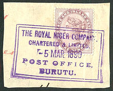
Julius Gbabojor Pondi is a Nigerian politician, member of the House of Representatives of Nigeria since 2015. In the House of Representatives, he represents Burutu Federal constituency of Delta State. He is a member of the People's Democratic Party (PDP).