
La Belle is a city in western Lewis County, Missouri, United States. The population was 664 at the 2020 census. It is part of the Quincy, IL–MO Micropolitan Statistical Area.

Paul William Henning was an American TV producer and screenwriter. Most famous for creating the television sitcom The Beverly Hillbillies, he was also crucial in developing the "rural" comedies Petticoat Junction (1963–1970) and Green Acres (1965–1971) for CBS.

The Spring River is a 129-mile-long (208 km) waterway located in southwestern Missouri, southeastern Kansas, and northeastern Oklahoma.
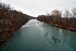
The James River is a 130-mile-long (210 km) river in southern Missouri. It flows from northeast Webster County until it is impounded into Table Rock Lake. It is part of the White River watershed. The river forms Lake Springfield and supplies drinking water for the city of Springfield.

Fiery Fork Conservation Area is a public area in Camden County, Missouri, along the Little Niangua River. It is 1,606 acres (6.50 km2) large. It is mostly wooded with oak trees and some open space. The park includes a small campground, fishing, hiking, hunting, wildlife viewing, and small-boat access to the Little Niangua River.
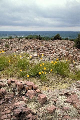
Hughes Mountain and the Hughes Mountain State Natural Area are located in southern Washington County, Missouri just south of the Big River and Highway M on Cedar Creek Road in the St. Francois Mountains range of The Ozarks. The mountain reaches an elevation of just over 1,200 feet, rising 430 feet above the Big River. The Hughes Mountain Natural Area of the Missouri Department of Conservation encompasses 462 acres (1.87 km2) of the mountain, including the rhyolite glade at its top.

The Missouri Department of Conservation (MDC) and the Missouri Conservation Commission were created by Article IV Sections 40-42 of the Missouri Constitution, which were adopted by the voters of the state in 1936 as Amendment 4 to the constitution. The Commission is vested with control, management, restoration, conservation, and regulation of fish, forest, and wildlife resources of the state. The Department of Conservation owns and oversees hatcheries, sanctuaries, refuges, and reservations, and enforces the state wildlife code. The Commission consists of four individuals appointed by the Governor of Missouri to serve unpaid 6-year terms. No more than two of the individuals may be from the same political party.

August A. Busch Memorial Conservation Area is a 6,987-acre (28.28 km2) conservation area that is owned and managed by the Missouri Department of Conservation. Located in St. Charles County, Missouri, the land was purchased by the Department of Conservation with help from Alice Busch, the wife of August Anheuser Busch, Sr., in 1947 from the U.S. Government.
Bismarck Conservation Area consists of 1,188 acres (4.81 km2) southwest of Bismarck, Missouri. The area surrounds 210 acres (85 ha) DiSalvo Lake. The lake was constructed in 1944 by Hanna Mining Company, and the Missouri Department of Conservation acquired the land from Hanna Mining Company in 1981.

The Seventy-Six Conservation Area is located in eastern Perry County, Missouri at the end of Route D, approximately four miles northeast of Brazeau. The Missouri Conservation Department created this area in 1990 with the purchase of an 818-acre farm from a private landowner.

Red Rock Landing Conservation Area is located in eastern Perry County, Missouri at the end of County Road 350, approximately ten miles east of Perryville, Missouri. The Missouri Conservation Department created this area in November 1994 with the purchase of 554-acres along the Mississippi River.

Hinkson Creek is a stream in Boone County in the U.S. state of Missouri. Its middle section runs through the city of Columbia, Missouri It was named after Robert Hinkson, a pioneer citizen who lived along its banks. Several trails, conservation areas, and parks are along its path. it eventually empties into Perche Creek southwest of Columbia. The MKT Trail follows the creek in Boone County.

Lake Springfield is a 318-acre artificial cooling lake located in Springfield, Missouri created for the James River Power Plant. It was built by placing a dam on the James River. It now serves as a popular fishing and recreation area. It is one of two sizeable fishing lakes near the city of Springfield, the other is Fellows Lake.
Rock Fork Lakes Conservation Area is a nature preserve and former strip mine in Boone County, Missouri. Located north of Columbia, Missouri adjacent to Finger Lakes State Park it is over 2000 acres of lakes, wetlands, forest, and prairie. Much of the land is severely degraded from strip mining by the Peabody Coal Company from 1963 to 1972. The land was acquired by the Missouri Department of Conservation in 1979. An unstaffed shooting range is open to the public and was renovated in 2014. The 50-acre Rocky Fork Lake has a boat ramp and is used for fishing. It is named after Rocky Fork Creek.
Bittersweet Woods Conservation Area is a 10-acre park located in the city of Des Peres in St. Louis County, Missouri. Positioned deep in suburban St. Louis, Bittersweet Woods offers outdoor recreational opportunities to nearby communities. The park is located on Barrett Station Road between Manchester Road and Dougherty Ferry Road.
Sara Parker Pauley is the director of the Missouri Department of Conservation and former president of the Association of Fish & Wildlife Agencies. In each of those roles she was the first woman to serve.
The Taberville Prairie Conservation Area is a 1,680-acre (685-hectare) unit, including a 1,360-acre tallgrass prairie which is a natural area located in St. Clair County in the U.S. state of Missouri. The conservation area is characterized by rolling tallgrass prairie, with outcrops of sandstone. The Taberville Prairie, located within the conservation area, is a National Natural Landmark.
Pickle Springs Natural Area is a 256.5-acre park location within Ste. Genevieve County in the U.S. state of Missouri. The site, a National Natural Landmark, is protected by the Missouri Department of Conservation. The natural area, a place of steep-sided rocky slopes, is characterized by small box canyons, sometimes called “shut-ins” because direct sunlight is shut out of them. Small, seasonal waterfalls trickle down the sides of the box canyons, providing nourishment for relict species that are otherwise rare in southern Missouri. Ferns and amphibians live here that are much more characteristic of the North American North Woods hundreds of miles away. Pickle Springs is located close to, although separate from, Hawn State Park. The nearest settlement is Farmington, Missouri. Access to the Natural Area requires hiking a 2-mile-long trail
The Maple Woods Natural Area is a natural area located in Clay County in the U.S. state of Missouri. The natural area is characterized by sugar maples. The 39.3-acre forest is recognized by the United States National Park Service as a Significant Natural Area. The small forest is a National Natural Landmark.
