
Banten is the westernmost province on the island of Java, Indonesia. Its capital city is Serang and its largest city is in Tangerang. The province borders West Java and the Special Capital Region of Jakarta on the east, the Java Sea on the north, the Indian Ocean on the south, and the Sunda Strait on the west and shares a maritime border with Bengkulu and Lampung to the east and Bangka Belitung Islands to the north. The province covers an area of 9,662.82 km2 (3,730.84 sq mi). It had a population of over 11.9 million in the 2020 census, up from about 10.6 million in 2010. The estimated mid-2022 population was 12.25 million. Formerly part of the province of West Java, Banten become a province in 2000. The northern half has recently experienced rapid rises in population and urbanization, and the southern half has a more traditional character but an equally fast-rising population.

Wakatobi Regency is a group of ca. 150 islands forming an administrative regency located in Southeast Sulawesi Province of Indonesia. The four largest islands are Wangi-wangi, Kaledupa, Binongko and Tomia. The capital of the regency is located on Wangi-wangi Island, and was established by virtue of Law of the Republic of Indonesia Number 29 of 2003 dated 18 December 2003. The regency has an area of 473.62 square kilometres and had a population of 92,922 at the 2010 Census and 111,402 at the 2020 Census; the official estimate as at mid 2022 was 115,286 - comprising 57,662 males and 57,624 females.
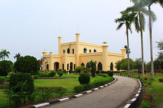
Siak, is a regency (kabupaten) of Riau Province, on the island of Sumatra, Indonesia. It has an area of 8,556.09 km² and had a population of 376,742 at the 2010 Census and 457,940 at the 2020 Census; the official estimate as at mid 2022 was 477,550, comprising 246,186 males and 231,364 females. The administrative centre of the regency is located at Siak Sri Indrapura. The northern part of this regency contains a large part of the Bukit Batu Biosphere Reserve.

The Bantenese people are an indigenous ethnic group native to Banten in the westernmost part of Java island, Indonesia. The area of Banten province corresponds more or less with the area of the former Banten Sultanate, a Bantenese nation state that preceded Indonesia. In his book "The Sultanate of Banten", Guillot Claude writes on page 35: “These estates, owned by the Bantenese of Chinese descent, were concentrated around the village of Kelapadua.” Most of Bantenese are Sunni Muslim. The Bantenese speak the Bantenese language, a variety of the Sundanese language which does not have a general linguistic register, this language is called Basa Sunda Banten.

Kutai is a historical region in what is now known as East Kalimantan, Indonesia on the island of Borneo and is also the name of the native ethnic group of the region, numbering around 300,000 who have their own language known as the Kutainese language which accompanies their own rich history. Today, the name is preserved in the names of three regencies in East Kalimantan province which are the Kutai Kartanegara Regency, the West Kutai Regency and the East Kutai Regency with the major river flowing in the heart of the region known as the Mahakam River. Kutai is known to be the place of the first and oldest Hindu kingdom to exist in East Indies Archipelago, the Kutai Martadipura Kingdom which was later succeeded by the Muslim Kutai Kartanegara Sultanate.

Somali architecture is the engineering and designing of multiple different construction types such as stone cities, castles, citadels, fortresses, mosques, temples, aqueducts, lighthouses, towers and tombs during the ancient, medieval and early modern periods in Somalia and other regions inhabited by Somalis, as well as the fusion of Somalo-Islamic architecture with Western designs in contemporary times.

The Diu Fortress is a Portuguese-built fortification located on the west coast of India in Diu. The fortress was built as part of Portuguese India's defensive fortifications at the eastern tip of the island of Diu during the 16th century. The fortress, which borders on the town of Diu, was built in 1535 subsequent to a defense alliance forged by Bahadur Shah, the Sultan of Gujarat and the Portuguese when Humayun, the Mughal Emperor attempted to annex this territory. It was strengthened over the years, till 1546. The Portuguese ruled over this territory from 1537 until the Indian invasion of December 1961. Today it is a landmark of Diu and one of the Seven Wonders of Portuguese Origin in the World.

Penyengat Island is an island in Tanjung Pinang, capital of the Riau Islands, Indonesia. It lies just off Bintan Island, close to the downtown of Tanjung Pinang. The island has historical significance, dating back to the 18th century, when it was established as a fort as part of the Sultanate of Johor-Riau by the Bugis people. The island contains the tomb of Raja Ali Haji, a 19th-century Bugis historian and scholar. It is a small island that is approximately 6 km from the downtown of Tanjung Pinang, Riau Islands province. This island measures approximately 2500 meters x 750 meters, and is approximately 35 km from the island of Batam. This island can be reached by using a boat or better known by pompong boat. By using pompong boat, it takes approximately 15 minutes drive.

Sultan Hasanuddin (Sultan Hasanuddin Tumenanga Ri Balla Pangkana; was the 16th Ruler of The Sultanate of Gowa as Sombaya Ri Gowa XVI from 1653 to 1669. He was proclaimed as Indonesian National Hero on 6 November 1973. The Dutch called Sultan Hasanuddin "the Rooster of the East" as he was described as aggressive in battle.

Fort Oranje is a 17th century Dutch fort on the island of Ternate in Indonesia.

Fort Kastela is a ruined Portuguese fortress located at the southwest coast of Ternate. It is famous for being the first colonial fortification constructed in the Spice Islands (Maluku) of Indonesia. Built by the Portuguese in 1522, it is also referred to in different languages as São João Baptista de Ternate or Fortaleza de Ternate (Portuguese), Ciudad del Rosario (Spanish) or Gammalamma. Today it is locally known as Kastella/Kastela.

The Butonese people is a collective term that embraces a number of ethnic groups of Buton and neighbouring islands in Southeast Sulawesi. Like many other ethnic groups in Sulawesi, the Butonese are seafarers and traders. Butonese have long since migrated to many parts of the Malay archipelago using smaller vessels ranging from those that can only accommodate five people to large boats that can hold up to about 150 tons of goods. In general, the Butonese are a community that inhabits the region of the historical Buton Sultanate. When the swapraja domain was abolished, so did the Buton Sultanate which ended in 1951. The area of the former Sultanate is now distributed over several regencies and cities of Southeast Sulawesi. Among them are Baubau, Buton Regency, South Buton Regency, Central Buton Regency, North Buton Regency, Wakatobi Regency and Bombana Regency.

Sultan Mahmud Badaruddin II Museum is a municipal museum in Palembang, Indonesia. The museum is established inside a 19th-century building former of the office of the colonial resident of South Sumatra. The building also houses the tourist department of Palembang.

The Sultanate of Palembang Darussalam was a sultanate in Indonesia whose capital was the city of Palembang in the southern part of the Indonesian island of Sumatra. It was proclaimed in 1659 by Susuhunan Abdurrahman (1659–1706) and dissolved by the colonial government of the Dutch East Indies on October 7, 1823. In 1825, its last ruler, Sultan Ahmad Najamuddin, was arrested and sent into exile on the island of Banda Neira in the Moluccas.

Sultan Babullah, also known as Sultan Baabullah was the 7th Sultan and 24th ruler of the Sultanate of Ternate in Maluku who ruled between 1570 and 1583. He is known as the greatest Sultan in Ternatan and Moluccan history, who defeated the Portuguese occupants in Ternate and led the Sultanate to a golden peak at the end of the 16th century. Sultan Babullah was commonly known as the Ruler of 72 (Inhabited) Islands in eastern Indonesia, including most of the Maluku Islands, Sangihe and parts of Sulawesi, with influences as far as Solor, East Sumbawa, Mindanao, and the Papuan Islands. His reign inaugurated a period of free trade in the spices and forest products that gave Maluku a significant role in Asian commerce.

Kota Batu is a historical as well as populated area in Bandar Seri Begawan, the capital of Brunei. It is home to the Kota Batu archaeological site, a few of the country's museums and two mausoleums of the earliest Sultans of Brunei. However, the place is still populated and at present it is a neighbourhood of the capital.
This is a list of emblems or coat of arms used in Indonesia. Indonesia is divided into 38 provinces, and each province is divided into regencies (kabupaten) and cities (kota). There are 416 regencies and 98 cities. Each province, regency, and city has its own emblem.
The Sultanate of Buton was an indigenous sultanate in what is today Indonesia. It used to rule over Buton island and adjacent areas within present-day Southeast Sulawesi province. It was a constitutional monarchy with its own written constitution and law, complete with bodies acting as a legislature, a system of judiciary, and executive power.

The Mempawah Kingdom, also known as the Mempawah Sultanate, was an Islamic Dayak kingdom located in a territory now known as the Mempawah Regency, West Kalimantan, Indonesia. The name Mempawah is taken from the term "Mempauh", which is the name of a tree that grows in the upper reaches of the river, also known as the Mempawah River. In its development, Mempawah became known as the name of one of the kingdoms and sultanates that developed in West Borneo. The history of Mempawah is divided into two periods, namely the Dayak kingdom based on Hindu teachings and the period of Islamic influence.

