
The Central Valley Project (CVP) is a federal power and water management project in the U.S. state of California under the supervision of the United States Bureau of Reclamation (USBR). It was devised in 1933 in order to provide irrigation and municipal water to much of California's Central Valley—by regulating and storing water in reservoirs in the northern half of the state, and transporting it to the water-poor San Joaquin Valley and its surroundings by means of a series of canals, aqueducts and pump plants, some shared with the California State Water Project (SWP). Many CVP water users are represented by the Central Valley Project Water Association.

The Carquinez Strait is a narrow tidal strait located in the Bay Area of Northern California, United States. It is part of the tidal estuary of the Sacramento and the San Joaquin rivers as they drain into the San Francisco Bay. The strait is eight miles (13 km) long and connects Suisun Bay, which receives the waters of the combined rivers, with San Pablo Bay, a northern extension of the San Francisco Bay.

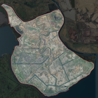
The Sacramento–San Joaquin River Delta, or California Delta, is an expansive inland river delta and estuary in Northern California. The Delta is formed at the western edge of the Central Valley by the confluence of the Sacramento and San Joaquin rivers and lies just east of where the rivers enter Suisun Bay, which flows into San Francisco Bay, then the Pacific Ocean via San Pablo Bay. The Delta is recognized for protection by the California Bays and Estuaries Policy. Sacramento–San Joaquin Delta was designated a National Heritage Area on March 12, 2019. The city of Stockton is located on the San Joaquin River at the eastern edge of the delta. The total area of the Delta, including both land and water, is about 1,100 square miles (2,800 km2). Its population is around 500,000.

The Mokelumne River is a 95-mile (153 km)-long river in northern California in the United States. The river flows west from a rugged portion of the central Sierra Nevada into the Central Valley and ultimately the Sacramento–San Joaquin River Delta, where it empties into the San Joaquin River-Stockton Deepwater Shipping Channel. Together with its main tributary, the Cosumnes River, the Mokelumne drains 2,143 square miles (5,550 km2) in parts of five California counties. Measured to its farthest source at the head of the North Fork, the river stretches for 157 miles (253 km).
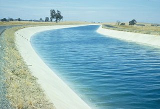
The Delta–Mendota Canal is a 117-mile-long (188 km) aqueduct in central California, United States. The canal was designed and completed in 1951 by the U.S. Bureau of Reclamation as part of the Central Valley Project. It carries freshwater to replace San Joaquin River water which is diverted into the Madera Canal and Friant-Kern Canal at Friant Dam.

The California Department of Water Resources (DWR) is part of the California Natural Resources Agency and is responsible for the management and regulation of the State of California's water usage. The department was created in 1956 by Governor Goodwin Knight following severe flooding across Northern California in 1955, where they combined the Division of Water Resources of the Department of Public Works with the State Engineer's Office, the Water Project Authority, and the State Water Resources Board. It is headquartered in Sacramento.

The delta smelt is an endangered slender-bodied smelt, about 5 to 7 cm long, in the family Osmeridae. Endemic to the upper Sacramento-San Joaquin Estuary of California, it mainly inhabits the freshwater-saltwater mixing zone of the estuary, except during its spawning season, when it migrates upstream to fresh water following winter "first flush" flow events. It functions as an indicator species for the overall health of the Delta's ecosystem.

Located in northern California, the Suisun Marsh has been referred to as the largest brackish water marsh on west coast of the United States of America. The marsh land is part of a tidal estuary, and subject to tidal ebb and flood. The marsh is home to many species of birds and other wildlife, and is formed by the confluence of the Sacramento and San Joaquin rivers between Martinez and Suisun City, California and several other smaller, local watersheds. Adjacent to Suisun Bay, the marsh is immediately west of the legally defined Sacramento-San Joaquin Delta as well as part of the San Francisco Bay estuary.

The California State Water Project, commonly known as the SWP, is a state water management project in the U.S. state of California under the supervision of the California Department of Water Resources. The SWP is one of the largest public water and power utilities in the world, providing drinking water for more than 27 million people and generating an average of 6,500 GWh of hydroelectricity annually. However, as it is the largest single consumer of power in the state itself, it has a net usage of 5,100 GWh.

The California Natural Resources Agency (CNRA) is a state cabinet-level agency in the government of California. The institution and jurisdiction of the Natural Resources Agency is provided for in California Government Code sections 12800 and 12805, et seq. The agency has six departments, 10 conservancies, 17 boards and commissions, three councils, and one urban park in Los Angeles that consists of two museums, the California Science Center and the California African American museum. Through its 25 departments, conservancies and commissions, the Natural Resources Agency is responsible for protecting prehistory history, natural landscapes and cultural sites, monitoring and stewarding state lands and waterways, and regulating fish and game use, as well as private lands and the intersection with federal lands and waters.

California's interconnected water system serves over 30 million people and irrigates over 5,680,000 acres (2,300,000 ha) of farmland. As the world's largest, most productive, and potentially most controversial water system, it manages over 40 million acre-feet (49 km3) of water per year.
California Reclamation Districts are legal subdivisions within California's Central Valley that are responsible for managing and maintaining the levees, fresh water channels, or sloughs, canals, pumps, and other flood protection structures in the area. Each is run autonomously and is run by an elected board and funded with taxes to property owners in the local area. However, the Central Valley Flood Protection Board has the power to determine that a district is not satisfactorily maintaining the structures and causing the California Department of Water Resources to declare an area as a maintenance area.
The San Francisco Estuary Partnership (Partnership) is one of the 28 National Estuary Programs created in the 1987 Amendments to the Clean Water Act. The Partnership is a non-regulatory federal-state-local collaboration working to restore water quality and manage the natural resources of the San Francisco Bay-Sacramento–San Joaquin River Delta estuary. The Partnership works with over 100 municipalities, non-profits, governmental agencies, and businesses and helps develop, find funding for, and implement over 40 projects and programs aimed at improving the health of the estuary. The partnership either directly implements these projects, or administers and manages grants, holds educational workshops and highlights project results. The Partnership is also the official representative for the San Francisco Bay region to the Most Beautiful Bays in the World.
The Sites Reservoir is a proposed $5.2 billion offstream reservoir project west of Colusa in the Sacramento Valley of northern California, to be built by the California Department of Water Resources. The project would pump 470,000 to 640,000 acre-feet per year of the winter flood flow from the Sacramento River upstream of the Sacramento–San Joaquin River Delta, through existing canals to an artificial lake 14 miles (23 km) away. Annual yield will depend on precipitation and environmental restrictions.
California Water Fix and Eco Restore, formerly known as the Bay Delta Conservation Plan, is a $15 billion plan proposed by Governor Jerry Brown and the California Department of Water Resources to build two large, four-story tall tunnels to carry fresh water from the Sacramento River under the Sacramento-San Joaquin Delta toward the intake stations for the State Water Project and the Central Valley Project.
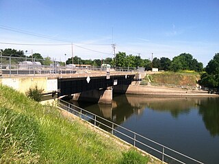
The Delta Cross Channel is a facility in California's Sacramento-San Joaquin Delta that diverts water from the Sacramento River. The facility was built in 1951 in Walnut Grove, California.

Winter Island is a 453-acre (183 ha) island in Suisun Bay, in the western Sacramento-San Joaquin River Delta. It is north of Pittsburg, separated from Browns Island to the west by a slough. It was private property, and contained one house. It is used as a duck hunting area, a wetland, and a dredging disposal area. In 2016 Winter Island was purchased by the California Department of Water Resources in order to restore the island as a tidal marsh. Winter Island is part of Contra Costa County, and managed by Reclamation District 2122. It is shown, labeled "Ruckels Island", on an 1850 survey map of the San Francisco Bay area made by Cadwalader Ringgold and an 1854 map of the area by Henry Lange.
The Delta Stewardship Council is a Government of California agency that is tasked with managing the Sacramento–San Joaquin River Delta.
Van Sickle Island is an approximately 10,000-acre (4,000 ha) island in Suisun Bay, California. It is part of Solano County, and administered by Reclamation District 1607. Its coordinates are 38°04′00″N121°54′04″W, and in 1981 the United States Geological Survey recorded its elevation as 0 ft (0 m). The island's land is divided into 22 privately-owned parcels, used primarily for duck clubs and private residences. A railroad bridge constructed in 1913 once connected it to Montezuma and Chipps Island, from which a ferry connected to Mallard Island and Pittsburg. The rail service was discontinued and the bridges no longer exist; currently, the island is accessible by water, as well as by road on bridges from Hammond Island and Wheeler Island.
