
Cumbria is a ceremonial county in North West England. It borders the Scottish council areas of Dumfries and Galloway and Scottish Borders to the north, Northumberland and County Durham to the east, North Yorkshire to the south-east, Lancashire to the south, and the Irish Sea to the west. Its largest settlement is the city of Carlisle.

Keswick is a market town and civil parish in the Cumberland unitary authority of Cumbria, England. Historically, until 1974, it was part of the county of Cumberland. It lies within the Lake District National Park, Keswick is just north of Derwentwater and is four miles from Bassenthwaite Lake. It had a population of 5,243 at the 2011 census.

Appleby-in-Westmorland is a market town and civil parish in Westmorland and Furness, Cumbria, England, with a population of 3,048 at the 2011 Census. Crossed by the River Eden, Appleby is the county town of the historic county of Westmorland. It was known just as Appleby until 1974–1976, when the council of the successor parish to the borough changed it to retain the name Westmorland, which was abolished as an administrative area under the Local Government Act 1972, before being revived as Westmorland and Furness in 2023. It lies 14 miles (23 km) south-east of Penrith, 32 miles (51 km) south-east of Carlisle, 27 miles (43 km) north-east of Kendal and 45 miles (72 km) west of Darlington.

Penrith is a market town and civil parish in the Westmorland and Furness district of Cumbria, England. It is less than 3 miles (5 km) outside the Lake District National Park and about 17 miles (27 km) south of Carlisle. It is between the Rivers Petteril and Eamont and just north of the River Lowther. The town had a population of 15,181 at the 2011 census. It is part of historic Cumberland.
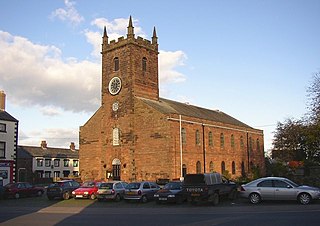
Wigton is a market town in Cumberland, Cumbria, England. It lies just outside the Lake District. Wigton is at the centre of the Solway Plain, between the Caldbeck Fells and the Solway coast. It is served by Wigton railway station on the Cumbrian Coast Line, and the A596 road to Workington. The town of Silloth-on-Solway lies 12 miles (19 km) to the west, beyond Abbeytown.

Shap is a village and civil parish located among fells and isolated dales in Westmorland and Furness, Cumbria, England. The village is in the historic county of Westmorland. The parish had a population of 1,221 in 2001, increasing slightly to 1,264 at the 2011 Census.

Bassenthwaite is a village and civil parish to the west of Bassenthwaite Lake in Cumbria, historically part of Cumberland, within the Lake District National Park, England. According to the 2001 census it had a population of 412, increasing to 481 at the 2011 Census. There is a Church of England Church, St John's Bassenthwaite and a tiny Methodist chapel. The village contains many elements of the archetypal English village including a green, primary school and a stream that runs through it.
Penrith was a rural district within the administrative county of Cumberland, England that existed from 1894 to 1974 with slight boundary changes in 1934.

Hesket is a large civil parish in the Eden District of Cumbria, England, on the main A6 between Carlisle and Penrith. At the 2001 census it had a population of 2,363, increasing to 2,588 at the 2011 census, and estimated at 2,774 in 2019. The parish was formed in 1894 with the passing of the Local Government Act 1894 and was enlarged to incorporate the parish of Plumpton Wall following a County Review Order in 1934. Hesket is part of the historic royal hunting ground of Inglewood Forest. Settlement in the parish dates back to the Roman occupation.
Dacre is a small village, civil parish and electoral ward in the Lake District National Park in the Eden District of Cumbria, England, and historically in Cumberland. In the 2001 census, the parish, which includes Newbiggin and Stainton, had a population of 1,326, increasing to 1,438 at the 2011 Census.

Plumpton or Plumpton Wall is a small village and former civil parish, now in the parish of Hesket, in the Westmorland and Furness district, in the ceremonial county of Cumbria, England. It is about 4 miles (6 km) north of Penrith. In 1931 the parish had a population of 320.

Skelton is a small village and civil parish about 7 miles (11 km) north west of Penrith in the English county of Cumbria. It is on the former route of the B5305 road, which is now about 1 mile (2 km) to the north. The parish had a population of 1,059 in 2001, increasing slightly to 1,153 at the 2011 Census.

The River Caldew is a river running through Cumbria in England. The river rises high up on the northern flanks of Skiddaw, in the Northern Fells area of the English Lake District, and flows in a northerly direction until it joins the River Eden on the north side of the city of Carlisle.

Great Cockup is a fell in the northern region of the English Lake District, one of the four Uldale Fells.

Ireby is a village in Cumbria, England, with a population of around 180. Between 1974 and 2023, it was in Allerdale district, Cumbria. Since April 2023, it is administered by Cumberland Council.

Hesket Newmarket is a small village in Cumbria, England, historically within Cumberland. It is on the opposite side of Skiddaw to Keswick within the Lake District National Park.

Camerton is a small village and civil parish in Cumbria, historically part of Cumberland, near the Lake District National Park in England. According to older maps, it was originally called "Camberton".
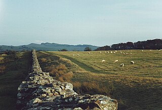
Cumberland is a unitary authority area in Cumbria, England, which means that is a non-metropolitan county and district. It borders Scotland, Northumberland, Westmorland and Furness, and the Irish Sea. Part of the area is in the Lake District National Park and notable landmarks include Carlisle Cathedral, Carlisle Castle and Hadrian's Wall.

Westmorland and Furness is a unitary authority area in Cumbria, England, which means that is a non-metropolitan county and district. The economy is mainly focused on tourism around both the Lake District and Cumbria Coast, shipbuilding and the port in Barrow-in-Furness, and agriculture in the rural parts of the area.


