
Waukesha County is a county in the U.S. state of Wisconsin. As of the 2020 United States Census, the population was 406,978, making it the third-most populous county in Wisconsin. Its county seat and largest city is Waukesha.

Washington County is a county in the U.S. state of Wisconsin. As of the 2020 census, the population was 136,761. Its county seat is West Bend. The county was created from Wisconsin Territory in 1836 and organized in 1845. It was named after President George Washington.

Butler is a village in Waukesha County, Wisconsin, United States. The population was 1,787 at the 2020 census.

Dousman is a village in Waukesha County, Wisconsin, United States. The population was 2,419 at the 2020 census.

New Berlin is a city located in eastern Waukesha County in the U.S. state of Wisconsin. The population was 40,451 at the 2020 census, making it the third-largest community in Waukesha County after the cities of Waukesha and Brookfield.
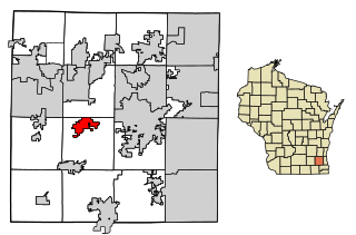
Wales is a village in Waukesha County, Wisconsin, first settled by Welsh immigrants. The population was 2,862 at the time of the 2020 census.

Kewaskum is a town in Washington County, Wisconsin, United States. The population was 1,119 at the 2000 census. The incorporated community of Village of Kewaskum is surrounded geographically by the Town of Kewaskum. The unincorporated community of Saint Michaels is located partially in the town.

The Milwaukee metropolitan area is a major metropolitan area located in Southeastern Wisconsin, consisting of the city of Milwaukee and some of the surrounding area. There are several definitions of the area, including the Milwaukee–Waukesha–West Allis metropolitan area and the Milwaukee–Racine–Waukesha combined statistical area. It is the largest metropolitan area in Wisconsin, and the 39th largest metropolitan area in the United States.

The Eastern Ridges and Lowlands is a geographical region in the eastern part of the U.S. state of Wisconsin, between Green Bay in the north, and the border with Illinois in the south. Lake Michigan lies to the east of the region.
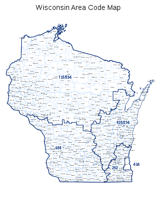
Area code 262 is a telephone area code in the North American Numbering Plan for the southeastern part of the U.S. state of Wisconsin. The numbering plan area comprises suburbs that are a part of the Milwaukee and Chicago metropolitan areas. The area code was created on September 25, 1999, in an area code split of area code 414.
Wisconsin's 5th congressional district is a congressional district of the United States House of Representatives in Wisconsin, covering most of Milwaukee's northern and western suburbs. It presently covers all of Washington and Jefferson counties, most of Waukesha County, and portions of Dodge, Milwaukee and Walworth counties. It is currently represented by Republican Scott Fitzgerald.

Waukesha County Technical College (WCTC) is a public community college in Waukesha County, Wisconsin. The college has campuses in Waukesha and Pewaukee. It is a member of the Wisconsin Technical College System.

Medina, originally Young's Corner, is an unincorporated community in the Town of Dale in southwest Outagamie County, Wisconsin, United States. It is located 3.5 miles (5.6 km) south of the village of Hortonville, 11 miles (18 km) west of Appleton, and 20 miles (32 km) northwest of Oshkosh.

Okee is an unincorporated community located in the town of Lodi, in Columbia County, Wisconsin, United States.

The Glacial Drumlin State Trail is a multipurpose rail trail in the U.S. State of Wisconsin. It stretches 52 miles (84 km) from Waukesha to Cottage Grove. The trail travels through or near the Wisconsin communities of Cottage Grove, Deerfield, London, Lake Mills, Jefferson, Helenville, Sullivan, Dousman, Genesee, Wales, and Waukesha. In Lake Mills, it crosses Rock Lake on one of its many old railroad bridges. The trail was opened in 1986 and follows the old Chicago and North Western Railway (C&NW) Madison–Milwaukee mainline.

Minnesota Junction is an unincorporated community located, in the town of Oak Grove, in Dodge County, Wisconsin, United States. Minnesota Junction is located on Wisconsin Highway 26. It is located at latitude 43.452 and longitude -88.697 at 925 feet above mean sea level.
Fort Howard was a city in Brown County, Wisconsin, United States. It was first incorporated as a "borough" of 664 acres on October 13, 1856. As the result of a referendum on the union of the two cities held on April 2, 1895, the city was entirely annexed to the City of Green Bay and ceased to exist.
Menomonee used to be a town in Waukesha County, Wisconsin, United States.

The Waukesha Beach Railway operated from 1895 until 1949 as an interurban railway from Waukesha to Pewaukee Lake in Wisconsin.

The New Berlin Trail is a 7-mile (11 km) shared-use path in Waukesha County, Wisconsin. It follows a former interurban route and a set of We Energies power lines.

