Kern County is a county located in the U.S. state of California. As of the 2020 census, the population was 909,235. Its county seat is Bakersfield.
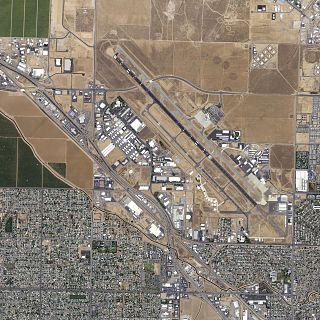
Meadows Field is a public airport in Kern County, California, United States, three miles northwest of Downtown Bakersfield. It is the main airport for the Bakersfield area, and one of two international airports in the San Joaquin Valley. Also known as Kern County Airport #1, it is located in an area of unincorporated Kern County adjacent to Oildale, California.

The Mojave Air and Space Port at Rutan Field is in Mojave, California, United States, at an elevation of 2,801 feet (854 m). It is the first facility to be licensed in the United States for horizontal launches of reusable spacecraft, being certified as a spaceport by the Federal Aviation Administration on June 17, 2004. The facility covers 2,998 acres and has three runways.

Modesto City–County Airport is two miles (3 km) southeast of Modesto in Stanislaus County, California, United States.

Henderson Executive Airport is a public use government airport located in Henderson, Nevada, 13 miles south of Las Vegas, in Clark County, Nevada. The airport is owned by the Clark County Commission and operated by the Clark County Department of Aviation. The FAA's National Plan of Integrated Airport Systems for 2009-2013 categorized it as a reliever airport.

Bakersfield Municipal Airport is a city-owned public-use airport located three nautical miles (6 km) south of the central business district of Bakersfield, a city in Kern County, California, United States. The airport is mostly used for general aviation.

Delano Municipal Airport is six miles southwest of Delano, in Kern County, California, United States.
Hanford Municipal Airport, formerly O18, is a mile (1.6 km) southeast of Hanford, in Kings County, California.

Kern Valley Airport is a public airport located in the Kern River Valley, 3 miles (4.8 km) south of Kernville in Kern County, California, United States. It serves the Lake Isabella area in the Southern Sierra Nevada.
Lost Hills Airport, also known as Lost Hills-Kern County Airport, was a public airport located one mile (1.6 km) northeast of the central business district (CBD) of Lost Hills, in Kern County, California, United States. It was mostly used for general aviation. It was closed in March 2019.

Tehachapi Municipal Airport is in Tehachapi, Kern County, California. It covers 264 acres (107 ha) and has one runway.
Taft Airport, also known as Taft-Kern County Airport, is a public airport located one mile (1.6 km) east of Taft, serving Kern County, California, USA. This general aviation airport covers 71 acres (29 ha) and has one runway. It is home to a skydive operation known as Skydive Taft.

Wasco Airport, also known as Wasco-Kern County Airport, is a public airport located two miles (3.2 km) northwest of Wasco, serving Kern County, California, USA. This general aviation airport covers 158 acres (64 ha) and has one runway.
Poso Airport, also known as Poso-Kern County Airport, is a county-owned public-use airport located four nautical miles (7 km) east of the central business district of Famoso, in Kern County, California, United States. It is mostly used for general aviation.
Elk Hills-Buttonwillow Airport is a public airport located three miles (5 km) south of the central business district (CBD) of Buttonwillow, in Kern County, California, United States. It is mostly used for general aviation.
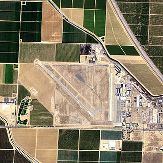
Shafter Airport, also known as Minter Field and formerly known as Air Corps Basic Flying School, is a public use airport located four nautical miles east of the central business district of Shafter and 14 miles northwest of Bakersfield, a city in Kern County, California, United States. Originally a World War II primary training facility for pilots, it is currently a public airport owned by the Minter Field Airport District. This airport is included in the National Plan of Integrated Airport Systems for 2011–2015, which categorized it as a general aviation facility.

Kissimmee Gateway Airport, formerly known as Kissimmee Municipal Airport, is a public airport in Kissimmee, a city in Osceola County, Florida, United States. The airport is located 16 nautical miles (30 km) southwest of the central business district of Orlando. It is owned and operated by the City of Kissimmee.

Mountain Valley Airport is a privately owned public-use airport located two nautical miles southeast of the central business district of Tehachapi, in Kern County, California, United States.
Rosamond Skypark is a residential airpark and public-use airport located three nautical miles (6 km) west of the central business district of Rosamond, in Kern County, California, United States. It is privately owned by the Rosamond Skypark Association.