Kern County, California

Last updated

Kern County
DowntownBakersfield.jpg
2009-0726-CA-NationalChavezCenter.jpg
Fort Tejon Barracks from CO Qtrs.JPG
F-35 at Edwards.jpg
MidwaySunsetWells.jpg
Images, from top down, left to right: Downtown Bakersfield, Cesar E. Chavez National Monument, Fort Tejon barracks, an F-35 landing at Edwards Air Force Base, the Midway-Sunset Oil Field
Seal of Kern County, California.png
Kern County, California
Interactive map of Kern County
Map of California highlighting Kern County.svg
Location in the state of California
Coordinates: 35°20′N118°43′W / 35.34°N 118.72°W / 35.34; -118.72
Country United States
State California
Incorporated April 2, 1866;158 years ago (1866-04-02)
Named for Kern River and Edward Kern
County seat Bakersfield
Largest cityBakersfield (population)
California City (area)
Incorporated cities11
Government
  Type Council–Administration
  Body Board of Supervisors [1] [2] [3] [4] [5]
  ChairJeff Flores (N.P.)
  Vice ChairZack Scrivner (N.P.)
  Board of Supervisors [6]
Supervisors
   Chief Administrative Officer [7] Ryan J. Alsop
Area
  Total8,163 sq mi (21,140 km2)
  Land8,132 sq mi (21,060 km2)
  Water31 sq mi (80 km2)
Highest elevation
[8]
8,755 ft (2,669 m)
Lowest elevation
[8]
206 ft (63 m)
Population
  Total909,235
  Density110/sq mi (43/km2)
Gross Domestic Product
  TotalUS$43.822 billion (2022)
Time zone UTC−8 (Pacific Time Zone)
  Summer (DST) UTC−7 (Pacific Daylight Time)
Area code 661, 760
FIPS code06-029
GNIS feature ID 2054176
Congressional districts 20th, 22nd, 23rd
Website www.co.kern.ca.us

Kern County is a county located in the U.S. state of California. As of the 2020 census, the population was 909,235. [9] Its county seat is Bakersfield. [11]

Contents

Kern County comprises the Bakersfield, California, Metropolitan statistical area. The county spans the southern end of the Central Valley. Covering 8,161.42 square miles (21,138.0 km2), it ranges west to the southern slope of the Coast Ranges, and east beyond the southern slope of the eastern Sierra Nevada into the Mojave Desert, at the city of Ridgecrest. Its northernmost city is Delano, and its southern reach extends to just beyond Frazier Park, and the northern extremity of the parallel Antelope Valley.

The county's economy is heavily linked to agriculture and to petroleum extraction. There is also a strong aviation, space, and military presence, such as Edwards Air Force Base, the China Lake Naval Air Weapons Station, and the Mojave Air and Space Port.

With a population that is 54.9% Hispanic as of 2020, Kern is California's third-most populous majority-Hispanic county and the sixth-largest nationwide. [12]

History

Indigenous Era

Native Americans lived in this region for hundreds of years: Chumash, tribes grouped together under the settler name Yokuts, and others. [13]

Spanish era

Spain claimed the area in 1769. Entering from Grapevine Canyon to the south in 1772, Commander Don Pedro Fages became the first European to set foot in the area.

The Battle of San Emigdio took place in Kern County in March 1824. The Chumash Native Americans of Mission Santa Barbara rebelled against the Mexican government and its taking over mission property and ejecting the natives. The battle occurred in the canyon where San Emigdio Creek flows down San Emigdio Mountain and the Blue Ridge, south of Bakersfield near today's Highway 166. Mexican forces from Monterey were commanded by Carlos Carrillo and the conflict was a low-casualty encounter, with only four Native Americans being killed and no Mexicans. The surviving Native Americans were pacified and brought back to Santa Barbara in June 1824 after a pursuit and negotiation in which many were allowed to keep their arms for the return march over the mountains. [14]

American era

The Havilah Court building was restored in the 1970s and now serves as a museum. Photo circa 2007. Havilah CA Courthouse Museum.JPG
The Havilah Court building was restored in the 1970s and now serves as a museum. Photo circa 2007.

In the beginning, what was to become Kern County was dominated by mining in the mountains and in the desert. In 1855 the California legislature attempted to form a county in the area by giving the southeastern territory of Tulare County on the west of the Sierra Nevada Mountains to Buena Vista County. However, it was never officially organized prior to 1859, when the enabling legislation expired. The south of Tulare County was later organized as Kern County in 1866, with additions from Los Angeles and San Bernardino Counties. Its first county seat was the mining town of Havilah, in the mountains east of Bakersfield and north of Tehachapi. [15]

Settlers considered the flat land of the valley inhospitable and impassable at the time due to swamps, lakes, tule reeds and diseases such as malaria. This changed when residents started draining land for farming and constructing canals, most dug by hired Chinese laborers. Within 10 years the valley surpassed the mining areas as the economic power of the county, and as a result the county seat was moved from Havilah to Bakersfield in 1874.[ citation needed ]

In 1899, the discovery well of the Kern River Oil Field was dug by hand [16] and soon the towns of Oil City, Oil Center and Oildale came into existence. [16]

Etymology

The county derives its name from the Kern River, which was named for Edward Kern, cartographer for General John C. Frémont's 1845 expedition, which crossed Walker Pass. The Kern River was originally named Rio Bravo de San Felipe by Father Francisco Garcés when he explored the area in 1776.

Earthquakes

Throughout recorded history, severe earthquakes have struck Kern County, including the 1857 Fort Tejon earthquake.

On July 21, 1952, an earthquake occurred with the epicenter about 23 miles (37 km) south of Bakersfield. It measured 7.3 on the moment magnitude scale and killed 12 people. In addition to the deaths, it was responsible for hundreds of injuries and more than $60 million in property damage. The main shock was felt over much of California and as far away as Phoenix, Arizona and Reno, Nevada. The earthquake occurred on the White Wolf Fault and was the strongest to occur in California since the 1906 San Francisco earthquake. Tehachapi suffered the greatest damage and loss of life from the earthquake, though its effects were widely felt throughout central and southern California. The event had a significant aftershock sequence that persisted into July and August with the strongest coming on August 22, an M5.8 event with a maximum perceived intensity of VIII (Severe) and resulted in two additional deaths and an additional $10 million in property damage. Repercussions of the sequence of earthquakes were still being felt in the heavily damaged downtown area of Bakersfield well into the 1990s as city leaders attempted to improve safety of the surviving non-reinforced masonry buildings.

Following the event, a field survey was conducted along the fault zone with the goal of estimating the peak ground acceleration of the shock based on visually evaluating rock formations and other indicators. Ground disturbances that were created by the earthquakes were also surveyed, both in the valley and in the foothills, with both vertical and horizontal displacements present in the epicenter area. The motion records that were acquired from the event were significant, and a reconnaissance report was recognized for its coverage of the event, and its setting a standard for similar engineering or scientific papers.

Abuse trials

Between 1983 and 1986, several ritual sex ring child abuse cases occurred in Kern County, resulting in numerous long prison sentences, all of which were overturned—some of them decades later, because the prosecutors had coerced false testimonies from the purported child victims. [17] The details of these false accusations are covered extensively in the 2008 documentary Witch Hunt, narrated by Sean Penn. [18]

Geography

Map of Kern County Kern County, California - Map (cropped).png
Map of Kern County

According to the United States Census Bureau, the county has a total area of 8,163 square miles (21,140 km2), of which 8,132 square miles (21,060 km2) is land and 31 square miles (80 km2) (0.4%) is water. [19] It is the third-largest county by area in California. The tallest peak in the county is Sawmill Mountain with an elevation of 8822 ft. Its area is nearly the size of the state of New Hampshire; it extends:

Air quality

Particulate pollution in Kern County varies with the seasons. PM 25 Kern County Bakersfield over time.jpg
Particulate pollution in Kern County varies with the seasons.

Kern County suffers from severe air pollution. Particulates cause poor visibility, especially in the winter. Western Kern County lies in the San Joaquin Valley and the topography traps pollutants. Although the topography is not as unfavorable in eastern Kern County, eastern Kern County is a non-attainment area for particulates. [20] Air pollution caused by particulates is "in the unhealthy range an average of 40 days a year, according to the American Lung Association's (ALA) 2018 State of the Air Report. [21]

Vegetation

Chaparral comprises a considerable portion of the natural area within Kern County; the species diversity within these chaparral habitats, however, is considerably less than in many other regions of California. [22] Whitethorn is a prominent example of chaparral species on the rocky slopes of the Sierra Nevada as well as the Inner Coastal Ranges. [23] California Buckeye is a notable tree found in both chaparral and forests and whose southern range terminates in Kern County. [24]

National protected areas

Demographics

Historical population
CensusPop.Note
1870 2,925
1880 5,60191.5%
1890 9,80875.1%
1900 16,48068.0%
1910 37,715128.9%
1920 54,84345.4%
1930 82,57050.6%
1940 135,12463.6%
1950 228,30969.0%
1960 291,98427.9%
1970 329,16212.7%
1980 403,08922.5%
1990 543,47734.8%
2000 661,64521.7%
2010 839,63126.9%
2020 909,2358.3%
2023 (est.)913,820 [25] 0.5%
U.S. Decennial Census [26]
1790–1960 [27] 1900–1990 [28]
1990–2000 [29] 2010 [30] 2020 [9]

According to the 2020 United States Census, Kern County's population was 909,235. [9] It was the eleventh-largest county by population in California. [31] The center of population of California is located in Kern County, in the town of Buttonwillow. [32]

2020 census

Kern County, California - Demographic Profile
(NH = Non-Hispanic)
Race / EthnicityPop 2010 [30] Pop 2020 [33] % 2010% 2020
White alone (NH)323,794279,60038.56%30.75%
Black or African American alone (NH)45,37746,7765.40%5.14%
Native American or Alaska Native alone (NH)5,8935,1970.70%0.57%
Asian alone (NH)33,10044,2573.94%4.87%
Pacific Islander alone (NH)9951,1270.12%0.12%
Some Other Race alone (NH)1,4724,5570.18%0.50%
Mixed Race/Multi-Racial (NH)15,96728,5631.90%3.14%
Hispanic or Latino (any race)413,033499,15849.19%54.90%
Total839,631909,235100.00%100.00%

Note: the US Census treats Hispanic/Latino as an ethnic category. This table excludes Latinos from the racial categories and assigns them to a separate category. Hispanics/Latinos can be of any race.

According to the 2020 United States Census: [34]

(Total can be greater than 100% because Hispanics may be counted in any race.)

2011

Places by population, race, and income

2010

The 2010 United States Census reported that Kern County had a population of 839,631. The racial makeup of Kern County was 499,766 (59.5%) White, 48,921 (5.8%) African American, 12,676 (1.5%) Native American, 34,846 (4.2%) Asian, 1,252 (0.1%) Pacific Islander, 204,314 (24.3%) from other races, and 37,856 (4.5%) from two or more races. Hispanic or Latino of any race were 413,033 persons (49.2%); 43.4% of Kern County residents are of Mexican heritage, 1.0% Salvadoran, 0.5% Colombian, and 0.4% Guatemalan. [43]

2000

According to the 2000 United States Census [44] of 2000, there were 661,645 people, 208,652 households, and 156,489 families residing in the county. The population density was 81 people per square mile (31 people/km2). There were 231,564 housing units at an average density of 28 units per square mile (11 units/km2). The racial makeup of the county was 61.6% White, 6.0% Black or African American, 3.4% Asian, 1.5% Native American, 0.2% Pacific Islander, 23.2% from other races, and 4.1% from two or more races. 38.4% of the population were Hispanic or Latino of any race. 8.4% were of German, 7.2% American and 5.7% Irish ancestry, according to the census. 66.8% spoke English, 29.1% Spanish and 1.0% Tagalog as their first language.

There were 208,652 households, out of which 42.2% had children under the age of 18 living with them, 54.6% were married couples living together, 14.5% had a female householder with no husband present, and 25.0% were non-families. 20.3% of all households were made up of individuals, and 7.8% had someone living alone who was 65 years of age or older. The average household size was 3.03 and the average family size was 3.50. [45]

In the county, the age distribution of the population shows 31.9% under the age of 18, 10.2% from 18 to 24, 29.8% from 25 to 44, 18.7% from 45 to 64, and 9.4% who were 65 years of age or older. The median age was 31 years. For every 100 females there were 105.3 males. For every 100 females age 18 and over, there were 105.3 males.

The median income for a household in the county was $35,446, and the median income for a family was $39,403. Males had a median income of $38,097 versus $25,876 for females. The per capita income for the county was $15,760. About 16.8% of families and 20.8% of the population were below the poverty line, including 27.8% of those under age 18 and 10.5% of those age 65 or over.

Arts and culture

Kern County is associated with the Bakersfield sound. The Buck Owens Crystal Palace is located in Bakersfield. [46]

Metropolitan statistical area

The United States Office of Management and Budget has designated Kern County as the Bakersfield, CA Metropolitan Statistical Area. [47] The United States Census Bureau ranked the Bakersfield, CA Metropolitan Statistical Area as the 63rd most populous metropolitan statistical area and the 68th most populous primary statistical area of the United States as of July 1, 2012. [48] [49]

Government, policing, and politics

Government

Kern County is a California Constitution-defined general law county and is governed by an elected Board of Supervisors. The Board consists of five members, elected by districts, who serve four-year staggered terms. The county government provides countywide services such as elections and voter registration, some law enforcement, jails, vital records, property records, tax collection, public health, and social services. In addition, the County serves as the local government for all unincorporated areas.

Safety

Fire

Logo of the Kern County Fire Department Kern County Fire Department Logo.png
Logo of the Kern County Fire Department

The Kern County Fire Department (KCFD) provides fire protection and emergency response services for the unincorporated areas of the county, as well as the cities of Arvin, Delano, Maricopa, McFarland, Ridgecrest, Shafter, Taft, Tehachapi and Wasco. [50]

Bakersfield has its own fire department, the Bakersfield Fire Department.

Sheriff

The Kern County Sheriff provides court protection, jail administration, and coroner services for the entire county of approximately 900,000 in population. It provides patrol and detective services for the unincorporated areas of the county and by contract to certain municipalities. The main Sheriff's office and station is at Bakersfield. There are 15 sheriff substations for the widespread county.

Municipal police

Municipal police departments in the county are: Bakersfield, population 384,000; Delano, 54,000; Ridgecrest, 29,000; Wasco (sheriff contract city), 28,000; Arvin, 21,000; Shafter, 20,000; McFarland, 15,000; California City, 14,671; Tehachapi, 13,000; Taft, 9,327; Maricopa (sheriff contract city), 1,200.

Politics and voter registration

Cities by population and voter registration

Federal

Kern is a strongly Republican county in Presidential and congressional elections. The last Democratic candidate for president to win a majority in the county was Lyndon Johnson in 1964. Kern remains the only county in Southern California that consistently votes Republican in recent elections. However, Republican margins in the county have shrunk recently, with Donald Trump's 10.2% margin of victory in 2020 being the smallest since Gerald Ford's 6.7% majority in 1976. This makes constituencies in Kern County in particular some of the most widely contested in California, and the United States as of the early 2020s, [52] [53] with the 2022 race for the 22nd US House district being close, and the 26th Senate District having one of the tightest margins in electoral history, with incumbent Democrat Melissa Hurtado retaining her seat by 13 votes. [54]

Democratic strength is concentrated in the small agricultural towns in the San Joaquin Valley portion of the county, such as Arvin, Delano, McFarland, Shafter and Wasco. Unincorporated communities close to agricultural areas, such as Lamont and Lost Hills, are Democratic strongholds. The eastern and southern parts of Bakersfield, along with unincorporated East Bakersfield have also become reliably Democratic. Republican strength is found in the foothill, mountain and high desert communities of the county. Cities like Maricopa, Ridgecrest and Taft are Republican strongholds. Along with the northern parts of Bakersfield, the wealthy unincorporated area of Rosedale and working-class Oildale are also seen as being strongly Republican. Cities like California City and the western areas of Bakersfield are seen as competitive in most elections. Bakersfield as a whole is seen as being competitive with a Republican lean. The remainder of the unincorporated areas of Kern County are seen as strongly Republican.

United States presidential election results for Kern County, California [55]
Year Republican Democratic Third party
No.%No.%No.%
2020 164,48453.88%133,36643.68%7,4422.44%
2016 129,58453.07%98,68940.42%15,8906.51%
2012 126,61856.99%89,49540.28%6,0762.73%
2008 134,79357.65%93,45739.97%5,5582.38%
2004 140,41766.49%68,60332.49%2,1541.02%
2000 110,66360.70%66,00336.20%5,6423.09%
1996 92,15153.77%62,65836.56%16,5829.67%
1992 80,76245.05%60,51033.75%37,99121.19%
1988 90,55061.48%55,08337.40%1,6601.13%
1984 94,77665.03%49,56734.01%1,4010.96%
1980 72,84259.65%41,09733.65%8,1826.70%
1976 58,02352.29%50,56745.57%2,3712.14%
1972 71,68660.14%41,93735.18%5,5704.67%
1968 53,99046.61%49,28442.55%12,55810.84%
1964 45,01441.18%64,17458.71%1200.11%
1960 52,80050.43%51,44049.13%4650.44%
1956 46,22051.31%43,53348.33%3220.36%
1952 46,49755.13%37,24044.16%6020.71%
1948 24,46441.60%33,02956.16%1,3182.24%
1944 20,73043.96%26,20555.56%2260.48%
1940 19,44537.30%32,20261.78%4790.92%
1936 8,34524.20%25,72674.61%4081.18%
1932 7,01125.11%19,63470.32%1,2754.57%
1928 14,69262.67%8,54136.43%2120.90%
1924 8,64646.08%3,15916.84%6,95837.08%
1920 7,07949.01%6,09542.20%1,2708.79%
1916 5,61135.11%9,56659.86%8045.03%
1912 670.62%5,56951.73%5,12947.65%
1908 2,27045.60%2,21544.50%4939.90%
1904 2,35951.61%1,72437.72%48810.68%
1900 1,69245.17%1,96052.32%942.51%
1896 1,43043.80%1,76354.00%722.21%
1892 99239.47%1,26650.38%25510.15%
1888 91041.46%1,22955.99%562.55%
1884 59842.02%79856.08%271.90%
1880 46340.94%66158.44%70.62%

In the United States House of Representatives, Kern County is split between California's 20th congressional district , seat currently vacant, California's 22nd congressional district , represented by Republican David Valadao, and California's 23rd congressional district , represented by Republican Jay Obernolte.

State

In the State Assembly, Kern County is split between the following four Assembly districts:

In the State Senate, Kern County is split between the 14th Senate District , represented by Democrat Anna Caballero, and the 16th Senate District , represented by Democrat Melissa Hurtado. [57]

On November 4, 2008, Kern County voted 75.29% in favor of Proposition 8, which amended the California Constitution to ban same-sex marriages. [58]

County

Kern County is governed by a five-member Board of Supervisors. Jeff Flores of District 3 currently serves as chairman. As of 2023, they are: [59]

Crime and public safety

Fire protection within the county is provided by the Kern County Fire Department. Law enforcement within the county is provided by the Kern County Sheriff's Department.

Fire

The Kern County Fire Department (KCFD) is an agency that provides fire protection and emergency medical services for the county of Kern, California, USA. Over 625 permanent employees and 100 extra help employees protect an area which spans over 8,000 square miles (21,000 km2). KCFD provides fire protection services for over 500,000 citizens living in the unincorporated areas of Kern County and the cities of Arvin, Delano, Maricopa, McFarland, Ridgecrest, Shafter, Taft, Tehachapi and Wasco. This agency is contracted to provide dispatch services for the California City Fire Department, Kern Ambulance based in Wasco, and Liberty Ambulance of Bakersfield. Over 546 uniformed firefighters are stationed in 46 fire stations throughout the county.

Sheriff's Office

The Kern County Sheriff's Department is the agency responsible for law enforcement within the county of Kern. The department provides law enforcement within the county, maintains the jails used by both the county and municipal cities, and provides search and rescue. The department contains over 1,200 sworn deputies and civilian employees. Its jurisdiction contains all of the unincorporated areas of Kern County, approximately 8,000 square miles (21,000 km2). The department headquarters is located at 1350 Norris Road in Bakersfield. There are 15 additional substations located throughout the county. The metro patrol area is divided into four regions: north, south, east, and west.

In 2009, the district attorney claimed "the highest per capita prison commitment rate of any major California county." Kern County contains multiple state and federal prisons, including two private prisons. The county is among the most prolific with the death penalty, assigning death penalty sentences in 26 cases since 1976. In 2015 Kern County policemen from all departments killed more people per capita than any other American county. Because of the very harsh local criminal justice system, Kern County has been dubbed "the most punitive authoritarian jurisdiction on the west coast" and "Oklahoma of the west". [60] In 2015, it was revealed that the Kern County Sheriff's office engaged in a longstanding program of attempted cash payoffs to women who had accused deputies of sexual assault. In the same year, a civil lawsuit filed by a survivor of a sexual assault committed by Kern County Sheriff's deputy Gabriel Lopez was settled for $1 million. [61]

Kern County had the most deaths per capita in the US by police shooting per an article published in The Guardian on December 1, 2015. [62] In 2015 to the date of publication of the article, there have been 13 deaths by police shootings in a county of less than 875,000 population, or 0.016 per thousand persons. By comparison, during the same period of time in New York City, a population 10 times the size with a police force more than 20 times the size, there were 9 such deaths. [63]

The following table includes the number of incidents reported and the rate per 1,000 persons for each type of offense.

Cities by population and crime rates

Economy

The county has a large agricultural base and is a significant producer of oil, natural gas, hydro-electric power, Biomass, solar power, and wind power. Kern is noted for minerals, including gold, borate, and kernite. The largest open pit mine in California, which mines borax, is at Boron. [67] As of October 1, 2016, Kern County contains nearly 25% of California's in-state renewable energy production, including 1,785 MW of solar power and 3,310 MW of wind power. [68] Kern County is home to the Tehachapi Energy Storage Project, which was commissioned in 2014. [69]

Aerospace and military

Department of Defense facilities include Edwards Air Force Base and China Lake Naval Air Weapons Station. As home to Edwards Air Force Base the Air Force's main flight test facility, Kern has been the site of many milestones, including the first supersonic flight and the first landing of the Space Shuttle. The base has brought prosperity to the railroad towns of Mojave and Rosamond. [70] Kern County is also the home of the first inland spaceport in the United States, the Mojave Spaceport. [71]

Agriculture

This has long been one of the county's biggest industries. [72] Between 2012 and 2013 the produced value of ag products increased 6%, to a total of $6.8 billion. [72] Grape is 31%, almond is 17%, milk is 13%, citrus is 11%, cattle + calves and pistachio are both 7%, carrots are only 6% (but that's 80% of carrots for the entire United States), hay is 4%, and cotton and potatoes are both 2%, of that. [72] This is one of the highest-producing locations in the United States for vegetables, and also for watermelons. [73] Vegetables are estimated to total $320 million every year. [73] There are about 1,938 farms, at an average size of 1,202 acres (486 ha) (however 41% are smaller than 50 acres (20 ha)), being the primary employment of 63% of operators. [72]

Major producer of almonds [74] with production greater than 100 million pounds (45,000 t; 50,000 short tons) annually. [72] That is third of all the counties, 16% of the state's production. [72] (See also almond in California.)

Pistachio is another important employer here. [75] The Michailides & Avenot group finds severe boscalid resistance in isolates of Alternaria alternata pathogenic on pistachio here. [75] They find extensive such resistance in a swathe from the center down into the central southern part of the state, but especially here. [75] (See also Pistachio in California and boscalid in California.)

The Glassy-Winged Sharpshooter (Homalodisca vitripennis) is a major insect pest in this county, including in this county's citrus groves. [76] (See also Glassy-Winged Sharpshooter in California.)

Petroleum

As of 2015, Kern is California's top oil-producing county, with 78% of the state's 56,653 active oil wells and 71% of oil production. [77] [78] The county produced 144.5 million barrels of oil in 2015, accounting for about 4% of overall U.S. oil production. [77] [79]

Discovery and development

Oil development began with the 1894 discovery of the Midway-Sunset Oil Field, now the third-largest in the United States, in the southwestern portion of Kern County near Maricopa. The 1899 discovery along the Kern River was a breakthrough in oil production. [16] Oil was refined here even before the establishment of the county. [16] The Buena Vista Petroleum Company was organized and incorporated in 1864. [16] Soon thereafter a refinery was built that operated until April 1867 when work ceased because of high freight charges. [16]

The 1910 Lakeview Gusher was the largest recorded oil strike in U.S. history. The well spewed approximately nine million barrels for 18 months before workers finally were able to cap it. [80]

Other big oil fields in southwestern Kern County discovered early in the 20th century include the Buena Vista, the South Belridge and the Cymric fields. The latter is the fastest-growing field in California in terms of barrels produced per year. [81] Later large fields include the Kern River Oil Field, the fifth-largest in the U.S., the adjacent Kern Front Oil Field, the Mount Poso Oil Field in the lower foothills of the Sierra north-northeast of Bakersfield and the Fruitvale Oil Field, which underlies much of the city of Bakersfield, along and north of the Kern River. [82] [83]

On July 22, 2009, Occidental Petroleum announced it had discovered the equivalent of 150 million to 250 million barrels of oil in Kern County, which the company called the largest oil discovery in California in 35 years. The find added about 10 percent to California's known reserves. Occidental's Ray Irani said it is likely that more oil would be found in the areas outside the initial six wells that tapped the discovery. Occidental has not revealed the exact location of the find, two-thirds of which is natural gas. BNET, an industry web publication, said the find would add to the company's 708 million barrels of proven reserves in California.[ citation needed ]

Petroleum today

The county today contributes more than three-quarters of all the oil produced onshore in California. [81] Some of the large oil fields in Kern County which are still active include:

Transportation

Major highways

Public transportation

Airports

Meadows Field is the only airport in the county served by scheduled commercial passenger flights.

Recreation

Outdoor recreational activities include horseback riding, water skiing (Lake Isabella, Lake Buena Vista, Lake Ming, and private ski ranches). Off-roading and other motorsports take place at Jawbone Canyon, California City, Randsburg, Willow Springs, Buttonwillow, Bakersfield Speedway, Famoso Raceway, and the half-mile Kern County Raceway Park. Hunting, paintball, white-water rafting, kayaking (Kern River), snow skiing (Shirley Meadows and Mount Pinos), shooting ranges (5 Dogs Range), hiking, biking (trails, paths, and roads), camping and fishing are also part of the recreational culture.

Media

Magazines

Newspapers

TV stations

Kern County is served by stations based in Bakersfield, including:

California City, Ridgecrest, and other areas in the Mojave Desert regions of eastern Kern County may instead receive Los Angeles stations.

Communities

Population reported at 2010 United States Census
The CountyTotal
Population
White African
American
Native
American
Asian Pacific
Islander
other
races
two or
more races
Hispanic
or Latino
(of any race)
Kern County839,631499,76648,92112,67634,8461,252204,31437,856413,033
Incorporated
city
Total
Population
White African
American
Native
American
Asian Pacific
Islander
other
races
two or
more races
Hispanic
or Latino
(of any race)
Arvin 19,30410,24719224015567,65580917,892
Bakersfield 347,483197,34928,3685,10221,43247877,68617,068158,205
California City 14,1209,1882,150132367591,4317935,385
Delano 53,04119,3044,1915016,7573020,3071,95137,913
Maricopa 1,15495812716211238232
McFarland 12,7075,4332361718466,33044711,625
Ridgecrest 27,61621,3871,1133411,2091431,8361,5874,941
Shafter 16,9888,150219198111197,64564613,634
Taft 9,3277,38839611893651,0232443,353
Tehachapi 14,4149,4261,297206238212,7255015,466
Wasco 25,54512,5791,951283180129,71482619,585
Census-designated
place
Total
Population
White African
American
Native
American
Asian Pacific
Islander
other
races
two or
more races
Hispanic
or Latino
(of any race)
Bear Valley Springs 5,1724,776744657389127399
Bodfish 1,9561,7584501334979189
Boron 2,2531,74616249474141104406
Buttonwillow 1,5085343611100890271,183
Cherokee Strip 22784040011722187
China Lake Acres 1,8761,601352916784104265
Derby Acres 322289010023936
Dustin Acres 65253949107128129
Edmundson Acres 279108531014319225
Edwards Air Force Base 2,0631,51816516991096159355
Fellows 1069415002411
Ford City 4,2782,7352815336321,1131811,971
Frazier Park 2,6912,2971631223212110528
Fuller Acres 99160713121032929768
Golden Hills 8,6567,235129124120156703631,674
Greenacres 5,5664,612491167085112001,119
Greenfield 3,9912,51271634511,1121872,263
Inyokern 1,09993014242524955116
Johannesburg 1721522280088
Keene 43138521080161047
Kernville 1,3951,25711970337882
Lake Isabella 3,4663,06969618773197339
Lake of the Woods 9178203181103431123
Lamont 15,1206,6771302307297,35165114,293
Lebec 1,4681,152144617014891395
Lost Hills 2,412132511712,232242,354
McKittrick 1151011100759
Mettler 1367400004319109
Mexican Colony 281162015009311227
Mojave 4,2382,3816385453198672261,592
Mountain Mesa 77768771662273277
North Edwards 1,05884743262016061179
Oildale 32,68427,463255590316302,6351,3956,301
Onyx 4754064900164030
Pine Mountain Club 2,3152,07929254505879231
Randsburg 69620420012
Rosamond 18,15011,2941,476221658663,2581,1776,230
Rosedale 14,05811,695208159389249975862,495
Smith Corner 5242271032326316440
South Taft 2,1691,404215551159677931
Squirrel Mountain Valley 5475092910131322
Stallion Springs 2,4882,23930263277975285
Taft Heights 1,9491,602153511022066441
Tupman 161149000021012
Valley Acres 527428110104245121
Weedpatch 2,6581,2128781401,2371092,484
Weldon 2,6422,37558211153115217
Wofford Heights 2,2002,0376411012679156
Other
unincorporated areas
Total
Population
White African
American
Native
American
Asian Pacific
Islander
other
races
two or
more races
Hispanic
or Latino
(of any race)
All others not CDPs (combined)138,64481,3055,0792,7301,90714141,6705,81282,746

Cities

Census-designated places

Unincorporated communities

Former places

Population ranking

The population ranking of the following table is based on the 2020 census of Kern County. [87]

county seat

RankCity/Town/etc.Municipal typePopulation (2020 Census)
1 Bakersfield City403,455
2 Delano City51,428
3 Oildale CDP36,135
4 Ridgecrest City27,959
5 Wasco City27,047
6 Rosamond CDP20,961
7 Shafter City19,953
8 Arvin City19,495
9 Rosedale CDP18,639
10 California City City14,973
11 McFarland City14,161
12 Lamont CDP14,049
13 Tehachapi City12,939
14 Golden Hills CDP9,578
15 Taft City8,546
16 Bear Valley Springs CDP5,592
17 Greenacres CDP5,496
18 Mojave CDP4,699
19 Ford City CDP4,348
20 Lake Isabella CDP3,573
21 Greenfield CDP3,447
22 Stallion Springs CDP3,139
23 Frazier Park CDP2,592
24 Pine Mountain Club CDP2,422
25 Lost Hills CDP2,370
26 Weldon CDP2,303
27 Wofford Heights CDP2,213
28 Weedpatch CDP2,206
29 Edwards AFB CDP2,135
30 South Taft CDP2,100
31 Boron CDP2,086
32 Bodfish CDP2,008
33 Taft Heights CDP1,999
34 China Lake Acres CDP1,757
35 Kernville CDP1,549
36 Buttonwillow CDP1,337
37 Lebec CDP1,239
38 North Edwards CDP1,054
39 Maricopa City1,026
40 Inyokern CDP988
41 Fuller Acres CDP917
42 Mountain Mesa CDP823
43 Lake of the Woods CDP790
44 Squirrel Mountain Valley CDP760
45 Dustin Acres CDP677
46 Smith Corner CDP594
47 Valley Acres CDP504
48 Keene CDP469
49 Onyx CDP457
50 Derby Acres CDP301
51 Edmundson Acres CDP296
52 Mexican Colony CDP283
53 Cherokee Strip CDP206
54 Tupman CDP177
55 Johannesburg CDP113
56 McKittrick CDP102
57 Mettler CDP90
58 Fellows CDP52
59 Randsburg CDP45

Education

School districts include: [88]

Unified:

Secondary:

Elementary:

The 2015 Disney film McFarland, USA , starring Kevin Costner, is based on the cross-country team in the city of McFarland, California, which is located in northern Kern County.

See also

Notes

  1. Other = Some other race + Two or more races
  2. Native American = Native Hawaiian or other Pacific Islander + American Indian or Alaska Native
  3. 1 2 Percentage of registered voters with respect to total population. Percentages of party members with respect to registered voters follow.

Related Research Articles

<span class="mw-page-title-main">Bakersfield, California</span> City in California, United States

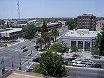
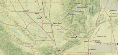
Bakersfield is a city in and the county seat of Kern County, California, United States. The city covers about 151 sq mi (390 km2) near the southern end of the San Joaquin Valley, which is located in the Central Valley region.

<span class="mw-page-title-main">California City, California</span> City in California, United States

California City is a city located in northern Antelope Valley in Kern County, California, United States. It is 100 miles (160 km) north of the city of Los Angeles, and the population was 14,973 at the 2020 census. Covering 203.63 square miles (527.4 km2), California City has the third-largest land area of any city in the state of California, and is the largest city in California, by land area, that is not a county seat. It is the 43rd-largest city in the United States by land area.

<span class="mw-page-title-main">Delano, California</span> City in California, United States

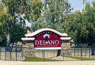
Delano is a city in Kern County, California, United States. Delano is located 31 miles (50 km) north-northwest of Bakersfield at an elevation of 315 feet (96 m). The population was 51,428 in 2020, down from 53,041 in 2010. It is Kern County's second-largest city after Bakersfield.

<span class="mw-page-title-main">Inyokern, California</span> Census designated place in California, United States

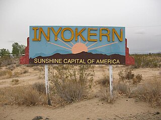
Inyokern is a census-designated place (CDP) in Kern County, California, United States. Its name derives from its location near the border between Inyo and Kern Counties. Inyokern is located 8 miles (13 km) west of Ridgecrest, at an elevation of 2,434 feet (742 m). It is on the western side of the Indian Wells Valley. The population was 988 in the 2020 census, down from 1,099 in the 2010 census. It was a railroad town established along the Southern Pacific railroad's Lone Pine Branch and with WWII became site of the Naval Air Weapons Station China Lake.

<span class="mw-page-title-main">Ridgecrest, California</span> City in California, United States

Ridgecrest is a city in Kern County, California, United States, along U.S. Route 395 in the Indian Wells Valley in northeastern Kern County, adjacent to the Naval Air Weapons Station China Lake. It was incorporated as a city in 1963. The population was 27,959 at the 2020 census, up slightly from 27,616 at the 2010 census.

<span class="mw-page-title-main">Rosamond, California</span> Unincorporated community in Kern County, California

Rosamond is an unincorporated community in Kern County, California, US, near the Los Angeles county line. Rosamond is part of Greater Los Angeles and is located in the Mojave Desert just north of Lancaster and Palmdale, two of the largest cities in Antelope Valley. As of the 2010 Census, Rosamond's population was 18,150. For statistical purposes, the United States Census Bureau has defined Rosamond as a census-designated place (CDP).

<span class="mw-page-title-main">Taft, California</span> City in California, United States

Taft is a city in the foothills at the extreme southwestern edge of the San Joaquin Valley, in Kern County, California. Taft is located 32 miles (51 km) west-southwest of Bakersfield, at an elevation of 955 feet (291 m). The population was 9,327 at the 2010 census. According to the United States Census Bureau, the city has a total area of 15.1 square miles (39.1 km2).

<span class="mw-page-title-main">Wasco, California</span> City in California, United States

Wasco is a city in the San Joaquin Valley, in Kern County, California, United States. Wasco is located 24 miles (39 km) northwest of Bakersfield, at an elevation of 328 feet (100 m). The population was 25,545 at the 2010 census, up from 21,263 at the 2000 census.

<span class="mw-page-title-main">Antelope Valley</span> Valley in Southern California, United States

The Antelope Valley is located in northern Los Angeles County, California, United States, and the southeast portion of California's Kern County, and constitutes the western tip of the Mojave Desert. It is situated between the Tehachapi, Sierra Pelona, and the San Gabriel Mountains. The valley was named for the pronghorns that roamed there until they were all eliminated in the 1880s, mostly by hunting, or resettled in other areas. The principal cities in the Antelope Valley are Palmdale and Lancaster.

<span class="mw-page-title-main">San Joaquin Valley</span> Area of the Central Valley in California

The San Joaquin Valley is the southern half of California's Central Valley. Famed as a major breadbasket, the San Joaquin Valley is an important source of food, producing a significant part of California's agricultural output.

<span class="mw-page-title-main">Area code 661</span> Area code in central and southern California, United States

Area code 661 is a telephone area code in the North American Numbering Plan for the southern part of the San Joaquin Valley and for the far northern part of the Los Angeles metropolitan area. The numbering plan area comprises most of Kern County, most of northern Los Angeles County, and small parts of Ventura County, Santa Barbara County, and Tulare County. It was created in an area code split of area code 805 on February 13, 1999.

The Bakersfield Californian is a daily newspaper serving Bakersfield, California and surrounding Kern County in the state's San Joaquin Valley.

California's 20th congressional district is a congressional district in California including much of the southern and southeastern part of the state's Central Valley. The district currently has no representative in the United States House of Representatives.

<span class="mw-page-title-main">California's 32nd State Assembly district</span> American legislative district

California's 32nd State Assembly district is one of 80 California State Assembly districts. It is currently represented by Republican Vince Fong of Bakersfield.

<span class="mw-page-title-main">Kern Transit</span> Public transit agency serving Kern County, California

Kern Transit, formerly Kern Regional Transit, is the operator of mass transportation in Kern County, California. Primarily, it provides inter-regional transportation, connecting outlying regions with the city of Bakersfield. It also provides inter-city transportation within specific regions. Kern (Regional) Transit is operated by the Kern County Department of Roads. The agency was founded in 1981. Its headquarters are located in Bakersfield.

<span class="mw-page-title-main">Transportation in Kern County, California</span>

Kern County’s transportation system was quoted as the “unseen industry.” Located at the southern end of the San Joaquin Valley, the county is at a prime location to ship goods west to the central coast, south to ports in Los Angeles, and east to corridors that connect to the rest of the country. It is also on major corridors that link to all northern points.

<span class="mw-page-title-main">Kern County Library</span>

The Kern County Library is a public library system serving the residents of Kern County, California. The library system is headquartered at the Beale Memorial Library in Downtown Bakersfield. There are additional branches located throughout Kern County. The library is also a part of the San Joaquin Valley Library System (SLVLS), which is a corporative network of library systems located throughout the San Joaquin Valley.

<span class="mw-page-title-main">Kern County Sheriff's Office</span> Law enforcement agency in California, US

The Kern County Sheriff's Office is the agency responsible for law enforcement within Kern County, California, in the United States. The agency provides: law enforcement within the county, maintain the jails used by both the county and municipalities, and provides search and rescue. Its jurisdiction contains all of the unincorporated areas of the county, approximately 8,000 square miles (21,000 km2). The headquarters is in Bakersfield with 15 substations located throughout the county. The metro patrol area is divided into four regions: north, south, east, and west. The Sheriff's Office has over 1,200 sworn officers and civilian employees.

References

  1. "Phillip Peters, Supervisor, District 1 from Kern County, California".
  2. "Zack Scrivner, Supervisor, District 2 from Kern County, California".
  3. "Mike Maggard, Supervisor, District 3 from Kern County, California".
  4. "David Couch, Supervisor, District 4 from Kern County, California".
  5. "Leticia Perez, Supervisor, District 5 from Kern County, California".
  6. "Board of Supervisors | Kern County, CA".
  7. "County Administrative Office | Kern County, CA".
  8. 1 2 Physical Features of Kern County Archived April 19, 2010, at the Wayback Machine . County of Kern. Retrieved July 22, 2010.
  9. 1 2 3 4 "QuickFacts Kern county, California". United States Census Bureau. Retrieved February 13, 2022.
  10. "Gross Domestic Product by County and Metropolitan Area, 2022" (PDF). www.bea.gov. Bureau of Economic Analysis.
  11. "Find a County". National Association of Counties. Archived from the original on May 31, 2011. Retrieved June 7, 2011.
  12. "P2: HISPANIC OR LATINO, AND NOT HISPANIC OR LATINO BY RACE". 2020 Census. United States Census Bureau. Retrieved October 10, 2021.
  13. "Native Land Digital Map". Native-Land.ca. Retrieved December 2, 2021.
  14. Hubert Howe Bancroft, History of California. The History Company, Publishers. San Francisco, 1886. pp. 532-536.
  15. 1865-1866 Calif. Stats., Chap. 569, § 3
  16. 1 2 3 4 5 6 Hoover, p.128
  17. Truth In Justice Archived April 13, 2015, at the Wayback Machine . Accessed January 28, 2008.
  18. Witch Hunt at IMDb OOjs UI icon edit-ltr-progressive.svg
  19. "2010 Census Gazetteer Files". United States Census Bureau. August 22, 2012. Retrieved September 26, 2015.
  20. Particulate Matter (PM-10) Nonattainment Area/State/County Report, September 16, 2010
  21. Borrell, Brendan (December 3, 2018). "In California's Fertile Valley, a Bumper Crop of Air Pollution". Undark. Retrieved September 27, 2019.
  22. The Wasmann Journal of Biology (1967) University of San Francisco, San Francisco, California, v.25
  23. Arthur Sampson (1963) California Range Brushlands and Browse Plants, ANR Publications, 162 pages ISBN   0-931876-54-0
  24. C. Michael Hogan. 2008. Aesculus californica, Globaltwitcher.com, ed. N. Strömberg Archived November 22, 2012, at the Wayback Machine
  25. "Annual Estimates of the Resident Population for Counties: April 1, 2020 to July 1, 2023". United States Census Bureau. Retrieved March 26, 2024.
  26. "Census of Population and Housing from 1790-2000". US Census Bureau . Retrieved January 24, 2022.
  27. "Historical Census Browser". University of Virginia Library. Retrieved September 26, 2015.
  28. Forstall, Richard L., ed. (March 27, 1995). "Population of Counties by Decennial Census: 1900 to 1990". United States Census Bureau. Retrieved September 26, 2015.
  29. "Census 2000 PHC-T-4. Ranking Tables for Counties: 1990 and 2000" (PDF). United States Census Bureau. April 2, 2001. Retrieved September 26, 2015.
  30. 1 2 "P2 HISPANIC OR LATINO, AND NOT HISPANIC OR LATINO BY RACE - 2010: DEC Redistricting Data (PL 94-171) - Kern County, California". United States Census Bureau .
  31. California State Association of Counties Archived May 12, 2011, at the Wayback Machine
  32. "California Center of Population".
  33. "P2 HISPANIC OR LATINO, AND NOT HISPANIC OR LATINO BY RACE - 2020: DEC Redistricting Data (PL 94-171) - Kern County, California". United States Census Bureau .
  34. "2020: DEC Redistricting Data (PL 94-171)" . Retrieved February 13, 2022.
  35. 1 2 3 4 5 6 7 8 9 10 11 12 13 14 15 16 17 U.S. Census Bureau. American Community Survey, 2011 American Community Survey 5-Year Estimates, Table B02001. U.S. Census website. Retrieved October 26, 2013.
  36. 1 2 U.S. Census Bureau. American Community Survey, 2011 American Community Survey 5-Year Estimates, Table B03003. U.S. Census website. Retrieved October 26, 2013.
  37. 1 2 U.S. Census Bureau. American Community Survey, 2011 American Community Survey 5-Year Estimates, Table B19301. U.S. Census website. Retrieved October 21, 2013.
  38. 1 2 U.S. Census Bureau. American Community Survey, 2011 American Community Survey 5-Year Estimates, Table B19013. U.S. Census website. Retrieved October 21, 2013.
  39. 1 2 U.S. Census Bureau. American Community Survey, 2011 American Community Survey 5-Year Estimates, Table B19113. U.S. Census website. Retrieved October 21, 2013.
  40. 1 2 U.S. Census Bureau. American Community Survey, 2011 American Community Survey 5-Year Estimates. U.S. Census website. Retrieved October 21, 2013.
  41. U.S. Census Bureau. American Community Survey, 2011 American Community Survey 5-Year Estimates, Table B01003. U.S. Census website. Retrieved October 21, 2013.
  42. Data unavailable
  43. "2010 Census P.L. 94-171 Summary File Data". United States Census Bureau.
  44. "U.S. Census website". United States Census Bureau . Retrieved May 14, 2011.
  45. "Volume I: Report – Chapter 3.12" (PDF). cms8.fra.dot.gov. Retrieved February 3, 2020.[ dead link ]
  46. "Home". Buck Owens. Retrieved October 27, 2023.
  47. "OMB Bulletin No. 13-01: Revised Delineations of Metropolitan Statistical Areas, Micropolitan Statistical Areas, and Combined Statistical Areas, and Guidance on Uses of the Delineations of These Areas" (PDF). United States Office of Management and Budget. February 28, 2013. Archived (PDF) from the original on January 21, 2017. Retrieved March 20, 2013.
  48. "Table 1. Annual Estimates of the Population of Metropolitan and Micropolitan Statistical Areas: April 1, 2010 to July 1, 2012". 2012 Population Estimates. United States Census Bureau, Population Division. March 2013. Archived from the original (CSV) on April 1, 2013. Retrieved March 20, 2013.
  49. "Table 2. Annual Estimates of the Population of Combined Statistical Areas: April 1, 2010 to July 1, 2012". 2012 Population Estimates. United States Census Bureau, Population Division. March 2013. Archived from the original (CSV) on May 17, 2013. Retrieved March 20, 2013.
  50. "Stations List". Kern County Fire Department. Archived from the original on March 17, 2014. Retrieved January 17, 2014.
  51. 1 2 3 4 5 6 7 8 9 10 11 12 13 14 15 16 17 California Secretary of State. February 10, 2013 — Report of Registration Archived July 27, 2013, at the Wayback Machine . Retrieved October 31, 2013.
  52. "Kern County isn't as 'red' as you might think it is". KERO 23 ABC News Bakersfield. November 7, 2022. Retrieved October 27, 2023.
  53. Hoeven, Emily (October 21, 2022). "Inside California's overlooked political powerhouse". CalMatters. Retrieved October 27, 2023.
  54. Patrick, Lacey (January 20, 2023). "Hurtado secures her victory in senate district 16 election". The Sun-Gazette Newspaper. Retrieved October 27, 2023.
  55. Leip, David. "Dave Leip's Atlas of U.S. Presidential Elections". uselectionatlas.org. Retrieved August 31, 2018.
  56. "Members Assembly". State of California. Retrieved April 11, 2013.
  57. "Senators". State of California. Retrieved April 11, 2013.
  58. "Statement of Vote: 2008 General Election" (PDF). California Secretary of State. December 13, 2008. Archived from the original (PDF) on May 6, 2013. Retrieved February 3, 2021.
  59. "Board of Supervisors | Kern County, CA". www.kerncounty.com. Retrieved March 1, 2023.
  60. Bslko, Radley (December 3, 2015). "America's killingest counties". Washington Post. Retrieved December 4, 2015.
  61. Laughland, Oliver (May 9, 2016). "California's Kern County settles for $1m over sexual assault by sheriff's deputy". The Guardian. Retrieved May 28, 2017.
  62. Swaine, Jon; Laughland, Oliver; Ryan, Mae; team, Guardian US interactive (December 1, 2015). "The County: the story of America's deadliest police". The Guardian. ISSN   0261-3077 . Retrieved January 30, 2019.
  63. Swaine, Jon; Laughland, Oliver; Ryan, Mae; Team, Guardian US Interactive (December 2015). "The County: the story of America's deadliest police". The Guardian. Retrieved May 28, 2017.
  64. 1 2 3 4 5 6 7 8 9 10 Office of the Attorney General, Department of Justice, State of California. Table 11: Crimes 2009 Archived December 2, 2013, at the Wayback Machine . Retrieved November 14, 2013.
  65. Only larceny-theft cases involving property over $400 in value are reported as property crimes.
  66. 1 2 3 United States Department of Justice, Federal Bureau of Investigation. Crime in the United States, 2012, Table 8 (California). Retrieved November 14, 2013.
  67. "Rio Tinto Borax : Home". Archived from the original on June 30, 2007. Retrieved July 4, 2007. Rio Tinto Borax. Accessed July 3, 2007.
  68. "Table 1: Number and Capacity of In-State Renewable Projects On-Line as of October 31, 2016". Tracking Progress: Renewable Energy – Overview (PDF) (Report). California Energy Commission. December 22, 2016.
  69. Edison International. "SCE Unveils Largest Battery Energy Storage Project in North America". Edison International. Retrieved May 10, 2020.
  70. Hoover, p. 134
  71. "Gateway to Space". www.faa.gov. Retrieved October 18, 2019.
  72. 1 2 3 4 5 6 "Kern County Facts" (PDF). Modesto: Almond Board of California. February 2015.
  73. 1 2 "Kern County Agriculture". UC Vegetable Research & Information Center . August 21, 2020. Retrieved September 11, 2022.
  74. Green, Miranda (April 10, 2021). "A California county, despite the state's climate goals, further embraces fossil fuels". Washington Post. ISSN   0190-8286 . Retrieved April 11, 2021.
  75. 1 2 3 Avenot, Hervé F.; Michailides, Themis J. (2010). "Progress in understanding molecular mechanisms and evolution of resistance to succinate dehydrogenase inhibiting (SDHI) fungicides in phytopathogenic fungi". Crop Protection . 29 (7). Elsevier (International Association for the Plant Protection Sciences (IAPPS)): 643–651. doi:10.1016/j.cropro.2010.02.019. ISSN   0261-2194. S2CID   41034322. HFA ORCID   0000-0001-6558-8472.
  76. "Glassy-Winged Sharpshooter Agriculture: Citrus Pest Management Guidelines". University of California Agriculture and Natural Resources (UCANR). 2017. 3441.
  77. 1 2 "Well Count And Production Of Oil, Gas And Water By County" (PDF). Division of Oil, Gas and Geothermal Resources. California Department of Conservation. 2015. Retrieved August 1, 2017.
  78. Hsu, Tiffany (January 30, 2015) "Plunging oil prices choke off boom in Bakersfield" Los Angeles Times
  79. "Crude Oil Production". Energy Information Administration. 2015.
  80. "The Story of the Lakeview Gusher". www.sjgs.com. Archived from the original on October 19, 2006. Retrieved May 28, 2017.
  81. 1 2 California Department of Conservation, Oil and Gas Statistics, Annual Report, December 31, 2006, p. 2
  82. Hluza, A.G. Calloway Area of Fruitvale Oil Field: California Division of Oil and Gas, Summary of Operations. 1961. Vol. 47 No. 2. 5-6
  83. DOGGR (2009), 63
  84. MAYER, STEVEN (October 4, 2015). "Rural neighborhood fielding a cluster of complaints".
  85. Martz, Matthew (September 28, 2012). "Victim of Old West Ranch shooting identified" . Retrieved May 28, 2017.
  86. "Tehachapi Life- Tehachapi, CA". www.tehachapilife.com. Retrieved May 28, 2017.
  87. "Explore Census Data". United States Census Bureau. Retrieved September 27, 2021.
  88. "2020 census - school district reference map: Kern County, CA" (PDF). U.S. Census Bureau . Retrieved July 25, 2022. - Text list

Further reading