
Kern County is a county located in the U.S. state of California. As of the 2020 census, the population was 909,235. Its county seat is Bakersfield.

Bakersfield is a city in Kern County, California, United States. It is the county seat and largest city of Kern County. The city covers about 151 sq mi (390 km2) near the southern end of the San Joaquin Valley and the Central Valley region. Bakersfield's population as of the 2020 census was 403,455, making it the 48th-most populous city in the United States of America and the 9th-most populous city in California. The Bakersfield–Delano Metropolitan Statistical Area, which includes all of Kern County, had a 2020 census population of 909,235, making it the 62nd-largest metropolitan area in the United States. The urban area that includes Bakersfield and areas immediately around the city, such as East Bakersfield, Oildale, and Rosedale, has a population of 570,235.

Lake of the Woods is an unincorporated area and census-designated place (CDP) in southwestern Kern County, California. As of the 2020 census, the population was 790.

Lamont is a census-designated place (CDP) in Kern County, California, United States. Lamont is located 9 miles (14 km) south-southeast of downtown Bakersfield, at an elevation of 404 feet (123 m). The population was 15,120 at the 2010 census, up from 13,296 at the 2000 census.

Oildale is a census-designated place (CDP) in Kern County, California, United States. Oildale is located 3.5 miles (5.6 km) north-northwest of downtown Bakersfield, at an elevation of 469 feet (143 m). The population was 32,684 at the 2010 census, up from 27,885 at the 2000 census. It is an unincorporated suburban town just north of Bakersfield across the Kern River, west of the Kern River Oil Field, and east of Highway 99.

Weedpatch is an unincorporated community and census-designated place (CDP) in Kern County, California, United States. Weedpatch is 10 miles (16 km) south-southeast of Bakersfield. It is considered to be one of the poorest areas in Kern County. As of the 2010 census it had a population of 2,658.

Kendall West is a census-designated place and unincorporated community in Miami-Dade County, Florida, west of the Florida Turnpike. The population was 36,536 at the 2020 census.
A census-designated place (CDP) is a concentration of population defined by the United States Census Bureau for statistical purposes only.
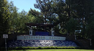
Stevenson Ranch is an unincorporated community in the Santa Clarita Valley of Los Angeles County, California. Stevenson Ranch is set in the foothills of the Santa Susana Mountains and lies west of Interstate 5 and the city of Santa Clarita. Stevenson Ranch encompasses about 6.4 square miles (17 km2). About 1,000 acres (4.0 km2) are set aside as parks, recreation areas, and open space. A master-planned community, it was approved by the county in 1987. The population was 20,178 at the time of the 2020 census. For statistical purposes, the Census Bureau has designated it a census-designated place (CDP).
Bakersfield Country Club is an 18-hole private golf course located in Bakersfield, California. The course is 6,819 yards on hilly terrain, designed by William P. Bell. Being located in the foothills of northeast Bakersfield makes this one of the few courses within Kern County that is naturally hilly. The club has reciprocating privileges to all private golf clubs in the Greater Bakersfield area. It is a championship course, which has hosted the Bakersfield Open Invitational between 1961 and 1962, which was a tournament on the PGA Tour.
Marlboro Village is an unincorporated community and census-designated place (CDP) in Prince George's County, Maryland, United States. Per the 2020 census, the population was 9,221. It was newly delineated for the 2010 census prior to which the area was part of the Greater Upper Marlboro census-designated place.
Queensland is a census-designated place south of Upper Marlboro in Prince George's County, Maryland, United States. The population of the CDP was 2,191 at the 2020 census. It was formerly known as Queenland until 2014 when its name was changed to Queensland and a small portion of its geography was transferred to Upper Marlboro.
Summerfield is a census-designated place near Landover in Prince George's County, Maryland. As of the 2020 census, the population was 14,758. It is a suburb of Washington, D.C.
Jovista is a census-designated place (CDP) in Tulare County, California, United States. It is on the southern border of the county, 5 miles (8 km) northeast of Delano, a city in Kern County. Jovista was first listed as a CDP prior to the 2020 census.
Bakersfield is the primary village and a census-designated place (CDP) in the town of Bakersfield, Franklin County, Vermont, United States. As of the 2020 census it had a population of 347, out of 1,273 in the entire town of Bakersfield.
Olde Stockdale is a neighborhood and census-designated place in Kern County, California. The population was 568 at the 2020 census.
Benton Park is a census-designated place (CDP) in Kern County, California. Although it is designated by the census as its own place, it is functionally a neighborhood of Bakersfield.
Casa Loma is a census-designated place (CDP) in Kern County, California. Although it is designated by the census as its own place, it is functionally a neighborhood of Bakersfield.
Choctaw Valley is the name of multiple neighborhoods and a census-designated place (CDP) in Kern County, California.
