
Kern County is a county located in the U.S. state of California. As of the 2020 census, the population was 909,235. Its county seat is Bakersfield.

Bakersfield is a city in Kern County, California, United States. It is the county seat and largest city of Kern County. The city covers about 151 sq mi (390 km2) near the southern end of the San Joaquin Valley and the Central Valley region. Bakersfield's population as of the 2020 census was 403,455, making it the 48th most populous city in the United States of America and the 9th most populous city in California. The Bakersfield–Delano Metropolitan Statistical Area, which includes all of Kern County, had a 2020 census population of 909,235, making it the 62nd largest metropolitan area in the United States. The urban area that includes Bakersfield and areas immediately around the city, such as East Bakersfield, Oildale, and Rosedale, has a population of 570,235.

Lake of the Woods is an unincorporated area and census-designated place (CDP) in southwestern Kern County, California. As of the 2020 census, the population was 790.

Lebec is an unincorporated community and census-designated place in southwestern Kern County, California. As of the 2010 census, the population was 1,468.

Pine Mountain Club is an unincorporated area and census-designated place in southwestern Kern County, California. As of the 2010 census it had a population of 2,315.

Weedpatch is an unincorporated community and census-designated place (CDP) in Kern County, California, United States. Weedpatch is 10 miles (16 km) south-southeast of Bakersfield. It is considered to be one of the poorest areas in Kern County. As of the 2010 census it had a population of 2,658.

West Athens is a census-designated place (CDP) in Los Angeles County, California. The population was 9,393 at the 2020 census. It is an unincorporated community within the 2nd Supervisorial District of Los Angeles County. West Athens is served by the Los Angeles County Sheriff's Department, operating out of the South Los Angeles Station. The approximate boundaries for West Athens are: 87th Street to the north, Vermont Avenue to the east, El Segundo Boulevard to the south, and approximately Western Avenue to Van Ness Avenue to the west. West Athens is predominantly residential, with commercial uses along its main corridors. Los Angeles Southwest Community College lies within the West Athens neighborhood and city limits.
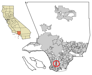
West Carson is an unincorporated community in Los Angeles County, California. The population was 21,699 at the 2010 census, up from 21,138 at the 2000 census. For statistical purposes, the United States Census Bureau has defined West Carson as a census-designated place (CDP).

Pine Manor is a census-designated place (CDP) located off U.S. Route 41 and Summerlin Road in Lee County, Florida, United States. The population was 4,122 at the 2020 census, up from 3,428 at the 2010 census. It is part of the Cape Coral-Fort Myers, Florida Metropolitan Statistical Area.

White Oak is a census-designated place and unincorporated area in Montgomery County, Maryland, United States. It had a population of 16,347 in 2020.

Woodmore is an unincorporated area and census-designated place in Prince George's County, Maryland, United States. Per the 2020 census, the population was 4,513. The CDP is located within the boundaries of Route 193 to the west, Church Road to the east, Route 214 to the south and Route 50 to the north. Woodmore Road runs east and west through the center. It contains a large gated community and country club, developments of Woodmore Meadows, and Woodmore South on the south side, as well as various other custom built homes and farmland.
A census-designated place (CDP) is a concentration of population defined by the United States Census Bureau for statistical purposes only.
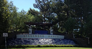
Stevenson Ranch is an unincorporated community in the Santa Clarita Valley of Los Angeles County, California. Stevenson Ranch is set in the foothills of the Santa Susana Mountains and lies west of Interstate 5 and the city of Santa Clarita. Stevenson Ranch encompasses about 6.4 square miles (17 km2). About 1,000 acres (4.0 km2) are set aside as parks, recreation areas, and open space. A master-planned community, it was approved by the county in 1987. The population was 20,178 at the time of the 2020 census. For statistical purposes, the Census Bureau has designated it a census-designated place (CDP).
The United States Census Bureau defines a place as a concentration of population which has a name, is locally recognized, and is not part of any other place. A place typically has a residential nucleus and a closely spaced street pattern, and it frequently includes commercial property and other urban land uses. A place may be an incorporated place or it may be a census-designated place (CDP). Incorporated places are defined by the laws of the states in which they are contained. The Census Bureau delineates CDPs. A small settlement in the open countryside or the densely settled fringe of a large city may not be a place as defined by the Census Bureau. As of the census, 26% of the people in the United States lived outside of places.
Bakersfield Country Club is an 18-hole private golf course located in Bakersfield, California. The course is 6,819 yards on hilly terrain, designed by William P. Bell. Being located in the foothills of northeast Bakersfield makes this one of the few courses within Kern County that is naturally hilly. The club has reciprocating privileges to all private golf clubs in the Greater Bakersfield area. It is a championship course, which has hosted the Bakersfield Open Invitational between 1961 and 1962, which was a tournament on the PGA Tour.
Olde Stockdale is a neighborhood and census-designated place in Kern County, California. The population was 568 at the 2020 census.
Casa Loma is a census-designated place (CDP) in Kern County, California. Although it is designated by the census as its own place, it is functionally a neighborhood of Bakersfield.
Choctaw Valley is the name of multiple neighborhoods and a census-designated place (CDP) in Kern County, California.
Rivergrove is a census-designated place (CDP) in Kern County, California. Although it is designated by the census as its own place, it is functionally a neighborhood of Bakersfield.
