
Gypsum is a soft sulfate mineral composed of calcium sulfate dihydrate, with the chemical formula CaSO4·2H2O. It is widely mined and is used as a fertilizer and as the main constituent in many forms of plaster, drywall and blackboard or sidewalk chalk. Alabaster, a fine-grained white or lightly tinted variety of gypsum, has been used for sculpture by many cultures including Ancient Egypt, Mesopotamia, Ancient Rome, the Byzantine Empire, and the Nottingham alabasters of Medieval England. Gypsum also crystallizes as translucent crystals of selenite. It forms as an evaporite mineral and as a hydration product of anhydrite.

Southern California is a geographic and cultural region that generally comprises the southern portion of the U.S. state of California. It includes the Los Angeles metropolitan area and also the Inland Empire. The region generally contains ten of California's 58 counties: Imperial, Kern, Los Angeles, Orange, Riverside, San Bernardino, San Diego, Santa Barbara, San Luis Obispo and Ventura counties.

An evaporite is a water-soluble sedimentary mineral deposit that results from concentration and crystallization by evaporation from an aqueous solution. There are two types of evaporite deposits: marine, which can also be described as ocean deposits, and non-marine, which are found in standing bodies of water such as lakes. Evaporites are considered sedimentary rocks and are formed by chemical sediments.

The Mojave River is an intermittent river in the eastern San Bernardino Mountains and the Mojave Desert in San Bernardino County, California, United States. Most of its flow is underground, while its surface channels remain dry most of the time, except for the headwaters and several bedrock gorges in the lower reaches.
Empire is an unincorporated community and census-designated place (CDP) in Washoe County, Nevada, with a population estimated at 65 (2021). It is part of the Reno–Sparks Metropolitan Statistical Area; before the 2010 census, it was part of the Gerlach–Empire census-designated place. The nearest town, Nixon, is 60 miles (97 km) to the south on a reservation owned by the Pyramid Lake Paiute Tribe.

The San Bernardino Mountains are a high and rugged mountain range in Southern California in the United States. Situated north and northeast of San Bernardino and spanning two California counties, the range tops out at 11,503 feet (3,506 m) at San Gorgonio Mountain – the tallest peak in Southern California. The San Bernardinos form a significant region of wilderness and are popular for hiking and skiing.

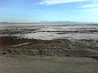
Searles Lake is an endorheic dry lake in the Searles Valley of the Mojave Desert, in northwestern San Bernardino County, California. The lake in the past was also called Slate Range Lake and Borax Lake.
Bristol Lake is a dry lake in the Mojave Desert of San Bernardino County, California, 42 km (26 mi) northeast of Twentynine Palms.
Cottonwood Canyon may refer to:

Arden, Nevada was an unincorporated community in Clark County, Nevada. The area is now part of the town of Enterprise. Located about 7 miles (11 km) southwest of Las Vegas, the area is experiencing rapid growth in housing development on land formerly owned by the Bureau of Land Management.

Searles Valley Minerals Inc. is a raw materials mining and production company with corporate offices in Overland Park, Kansas. It is owned by the Indian company Nirma. It has major operations in the Searles Valley centered in Trona, California where it is the town's largest employer. The company produces borax, boric acid, soda ash, salt cake, and salt. It also owns the Trona Railway.

Searles Valley is a census-designated place (CDP) in the Searles Valley of the Mojave Desert, in northwestern San Bernardino County, California.
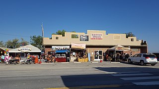
Trona is an unincorporated community in San Bernardino County, California. In 2015 it had a population of approximately 1,900. Trona is at the western edge of Searles Lake, a dry lake bed in Searles Valley, southwest of Death Valley. The town takes its name from the mineral trona, abundant in the lakebed. It is about 170 miles (274 km) northeast of Los Angeles, on State Route 178. The ZIP code is 93562.

The Salt Spring Hills are a low mountain range in the Mojave Desert, in northern San Bernardino County, California. They are just outside the southeastern corner of Death Valley National Park, southeast of the Saddle Peak Hills. The road between Shoshone and Baker passes through the hills.
Saltdale is an unincorporated community in Kern County, California. It is located near Koehn Lake 21 miles (34 km) south-southwest of Ridgecrest near Garlock, California.
Koehn Lake is a dry lake, and seasonally endorheic lake, in the Fremont Valley of the Mojave Desert, in eastern Kern County, California.
Barnwell, originally a rail camp named Summit, then Manvel, was a former railhead serving local mining camps, now a ghost town, in San Bernardino County, California. It lies at an elevation 4806 feet in the New York Mountains.

The Potash wars were a series of events that took place from 1910 to 1915 in the Searles Valley near Searles Lake, a dry lake, near the current town of Trona in the San Bernardino County of California. The Potash wars gained national and international news at the time due to the involvement of famous lawman Wyatt Earp and the importance of the valley's supply of potash at the time. Potash is an important crop fertilizer and the Searles Valley was a major supplier in the 1910s.

The Salina Group or Salina Formation is a Late Silurian-age, Stratigraphic unit of sedimentary rock that is found in Northeastern and Midwestern North America. Named for its Halite beds, the phrase "Salina Group" was first used as a descriptive term by James D. Dana in 1863.


