Related Research Articles

Bear Valley Springs is a guarded-gate community in Kern County, California, United States. The unincorporated community is in the Tehachapi Mountains and is part of the greater Tehachapi area. The elevation ranges from 4,121 feet (1,256 m) to 6,934 feet (2,113 m). The population fluctuates between a low during the winter months when snow is common, to a high in the summer months when its elevation keeps it much cooler than surrounding areas and major cities. The population was 5,172 at the 2010 census, up from 4,232 at the 2000 census. For statistical purposes, the United States Census Bureau has defined Bear Valley Springs as a census-designated place (CDP). The census definition of the area may not precisely correspond to local understanding of the area with the same name.

Keene is a census-designated place (CDP) in Kern County, California in the foothills of the Tehachapi Mountains at the southern extreme of the San Joaquin Valley. Keene is located 8.5 miles (14 km) northwest of Tehachapi, at an elevation of 2,602 feet (793 m). The population was 469 at the 2020 census, up from 431 at the 2010 census.

Mojave is an unincorporated community in Kern County, California, United States. Mojave is located 50 miles (80 km) east of Bakersfield, and 100 miles (161 km) north of Los Angeles, at an elevation of 2,762 feet (842 m). The town is located in the western region of the Mojave Desert, below and east of Oak Creek Pass and the Tehachapi Mountains. Mojave is on the Pacific Crest Trail.

Tehachapi is a city in Kern County, California, United States, in the Tehachapi Mountains, at an elevation of 3,970 feet (1,210 m), between the San Joaquin Valley and the Mojave Desert. Tehachapi is 35 miles (56 km) east-southeast of Bakersfield, and 20 miles (32 km) west of Mojave. According to the United States Census Bureau, the city has a total area of 10 square miles (26 km2) and a population of 14,414. The Tehachapi area is known for the nearby Tehachapi Loop, the Pacific Crest Trail and for the excellent conditions for the aerial sport of gliding.

Colfax is a city in Placer County, California, at the crossroads of Interstate 80 and State Route 174. The population was 1,963 at the 2010 census. The town is named in honor of U.S. Vice President Schuyler Colfax (1869–73), a bronze statue of whom stands at Railroad Street and Grass Valley Street.

Promontory is an area of high ground in Box Elder County, Utah, United States, 32 mi (51 km) west of Brigham City and 66 mi (106 km) northwest of Salt Lake City. Rising to an elevation of 4,902 feet (1,494 m) above sea level, it lies to the north of the Promontory Mountains and the Great Salt Lake. It is notable as the location of Promontory Summit, where the First transcontinental railroad from Sacramento to Omaha in the United States was officially completed on May 10, 1869. The location is sometimes confused with Promontory Point, a location further south along the southern tip of the Promontory Mountains. Both locations are significant to the Overland Route: Promontory Summit was where the original, now abandoned, alignment crossed just north of the Promontory Mountains; while Promontory Point is where the modern alignment, called the Lucin Cutoff, crosses the southern tip of the Promontory Mountains.
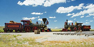
Golden Spike National Historical Park is a United States National Historical Park located at Promontory Summit, north of the Great Salt Lake in east-central Box Elder County, Utah, United States. The nearest city is Corinne, approximately 23 miles (37 km) east-southeast of the site.

The Tehachapi Loop is a 3,779-foot-long spiral, or helix, on the Union Pacific Railroad Mojave Subdivision through Tehachapi Pass, of the Tehachapi Mountains in Kern County, south-central California. The line connects Bakersfield and the San Joaquin Valley to Mojave in the Mojave Desert.
Wonder Acres is a settlement in the western Mojave Desert, within eastern Kern County, southern California, in the United States.

The Cahuenga Pass, also known by its Spanish name Paseo de Cahuenga, is a low mountain pass through the eastern end of the Santa Monica Mountains in the Hollywood Hills district of the City of Los Angeles, California. It has an elevation of 745 ft (227 m). The Cahuenga Pass connects the Los Angeles Basin to the San Fernando Valley via U.S. Route 101 and Cahuenga Boulevard. It is the lowest pass through the mountains.

Cajon Pass is a mountain pass between the San Bernardino Mountains to the east and the San Gabriel Mountains to the west in Southern California. Created by the movements of the San Andreas Fault, it has an elevation of 3,777 ft (1,151 m). Located in the Mojave Desert, the pass is an important link from the Greater San Bernardino Area to the Victor Valley, and northeast to Las Vegas. The Cajon Pass area is on the Pacific Crest Trail.

Caliente is an unincorporated community in Kern County, California. It is located 22 miles (35 km) east-southeast of Bakersfield, at an elevation of 1,312 feet (400 m).
The Fremont Valley is a valley located in the western Mojave Desert of California.

Laws is an unincorporated community in Inyo County, California. Laws is located 4 miles (6.4 km) northeast of Bishop on U.S. Route 6, towards the Nevada state line.

Havilah is an unincorporated community in Kern County, California. It is located in the mountains between Walker Basin and the Kern River Valley, 5 miles (8.0 km) south-southwest of Bodfish at an elevation of 3,136 feet (956 m).

Monroe High School is the main continuation high school that is located just outside Tehachapi, California. Monroe has one principal, a secretary and office clerk, two part-time counselors and three full-time teachers. The school is also the site of the Monroe Independent Study Center, and Tehachapi Adult School. Monroe is part of the Tehachapi Unified School District. After the 2010–2011 school year, the district plans on moving Monroe High School to the former junior high school building.
Tejon Creek, originally in Spanish Arroyo de Tejon, is a stream in Kern County, California. Its headwaters are located on the western slopes of the Tehachapi Mountains, and it flows northwest into the southern San Joaquin Valley.

The Errea House, a historic house located at 311 S. Green St. in Tehachapi, California, is the house is the only surviving building from the settlement of Tehichipa, the first town in the Tehachapi area. Tehichipa was founded in 1869, and the house was built sometime between 1870 and 1875. In 1876, the Southern Pacific Railroad bypassed Tehichipa, instead establishing a new townsite at Tehachapi Summit, which later became Tehachapi. The railroad's action led to the decline of Tehichipa's shipping industry, and the town's residents gradually moved to Tehachapi. The Errea House was moved to Tehachapi as well around 1900. No buildings from the original settlement survive at the site of Tehichipa, and the Errea House is the only building remaining from the town. The Errea House is now located across from the Tehachapi Museum, where it helps illustrate the city's early history.

The Tehachapi Railroad Depot was a railroad station in Tehachapi, California. The Southern Pacific Railroad built the line through the area in 1876. The depot was built in 1904 after the original station building was destroyed in a fire. the railroad founded the town of Tehachapi and drew the residents of nearby Tehichipa to the new settlement. The depot served a significant section of railroad, as it was located near the Tehachapi Loop and was one of the most active rural stations during World War II. The station later served as a warehouse and a railroad office.
References
- 1 2 3 Durham, David L. (1998). California's Geographic Names: A Gazetteer of Historic and Modern Names of the State. Clovis, Calif.: Word Dancer Press. p. 1083. ISBN 1-884995-14-4.
- ↑ Troy, D.; M. Farrell; J. C. Sammis (February 14, 1997). "National Register of Historic Places Registration Form: Errea House". National Park Service . Retrieved April 20, 2013.

35°05′09″N118°12′31″W / 35.0858°N 118.2085°W
| | This Kern County, California-related article is a stub. You can help Wikipedia by expanding it. |