Sageland, California

Last updated
Sageland
Unincorporated community
California Locator Map with US.PNG
Red pog.svg
Sageland
Location in California
Usa edcp location map.svg
Red pog.svg
Sageland
Sageland (the US)
Coordinates: 35°28′48″N118°12′45″W / 35.48000°N 118.21250°W / 35.48000; -118.21250 Coordinates: 35°28′48″N118°12′45″W / 35.48000°N 118.21250°W / 35.48000; -118.21250
Country United States
State California
County Kern County
Elevation [1] 4,026 ft (1,227 m)

Sageland (formerly, El Dorado Camp) [2] is an unincorporated community in Kern County, California. [1] It is located near Kelso Creek 3.5 miles (5.6 km) west-northwest at the base of the Piute Mountains, [2] at an elevation of 4,026 feet (1,227 m). [1]

Unincorporated area Region of land not governed by own local government

In law, an unincorporated area is a region of land that is not governed by a local municipal corporation; similarly an unincorporated community is a settlement that is not governed by its own local municipal corporation, but rather is administered as part of larger administrative divisions, such as a township, parish, borough, county, city, canton, state, province or country. Occasionally, municipalities dissolve or disincorporate, which may happen if they become fiscally insolvent, and services become the responsibility of a higher administration. Widespread unincorporated communities and areas are a distinguishing feature of the United States and Canada. In most other countries of the world, there are either no unincorporated areas at all, or these are very rare; typically remote, outlying, sparsely populated or uninhabited areas.

Kern County, California County in California, United States

Kern County is a county in the U.S. state of California. As of the 2010 census, the population was 839,631. Its county seat is Bakersfield.

Piute Mountains mountain range of Southern California

The Piute Mountains are a mountain range located in the Eastern Mojave Desert and within Mojave Trails National Monument, in San Bernardino County, California.

Quartz was discovered in the area in 1866 by miners from nearby Claraville. The New El Dorado Mining District was formed that year; the first mining settlement, El Dorado Camp, was renamed Sageland in 1867. By the spring of 1868, Sageland had become a boomtown with a population of almost a thousand, complete with multiple saloons, a billiard room, hotel, two stage lines to Havilah, and an opera house. Later that year, a silver rush occurred in White Pine County, Nevada, attracting legions of miners from Sageland and other California boom towns, an exodus known as 'White Pine Fever'. The St. John Mine closed in 1875 and by the next year, Sageland was essentially a ghost town. No structures remain from the original settlement, only fragments of stone walls.[ citation needed ]

Boomtown community that experiences sudden and rapid population and economic growth

A boomtown is a community that undergoes sudden and rapid population and economic growth, or that is started from scratch. The growth is normally attributed to the nearby discovery of a precious resource such as gold, silver, or oil, although the term can also be applied to communities growing very rapidly for different reasons, such as a proximity to a major metropolitan area, huge construction project, or attractive climate.

Havilah refers to both a land and people in several books of the Bible.

White Pine County, Nevada county in Nevada, United States

White Pine County is a largely rural, mountain county along the central eastern boundary of the U.S. state of Nevada. As of the 2010 census, the population was 10,030. Its county seat is Ely. The name "White Pine" is an old name for the Limber Pine, a common tree in the county's mountains.

The area was the site of a large village of Kawaiisu Indians. They were frequently accused of cattle rustling by white settlers, who would often retaliate mercilessly. [2] Cup holes and pictographs are present in the vicinity.

Kawaiisu

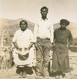
The Kawaiisu are a Native Californian ethnic group in the United States, which lives in the southern California Tehachapi Valley and across the Tehachapi Pass in the southern Sierra Nevada Mountains to the north, toward Lake Isabella and Walker Pass. Historically, the Kawaiisu also traveled eastward on food-gathering trips to areas in the northern Mojave Desert, to the north and northeast of the Antelope Valley, as far east as the Panamint Valley, the Panamint Mountains, and the western edge of Death Valley. Today, some Kawaiisu people are enrolled in the Tule River Indian Tribe.

Related Research Articles

El Dorado, California Unincorporated community in California, United States

El Dorado, not to be confused with the nearby El Dorado Hills, is an unincorporated community in El Dorado County, California. It is located 4 miles (6.4 km) southwest of Placerville, at an elevation of 1608 feet. The population was 4,096 at the 2000 census. The town is registered as California Historical Landmark #486. The ZIP code is 95623. The community is inside area code 530.

Rescue, California Unincorporated community in California, United States

Rescue is an unincorporated community in El Dorado County, California. It is located north-northwest of Shingle Springs and north-northeast of Cameron Park. The zip code is 95672, and Rescue is located in area code 530. The town lies at an elevation of 1214 feet. It has also been noted for its unusual place name. Formerly Green Valley, El Dorado County, California

Frenchtown, El Dorado County, California Unincorporated community in California, United States

Frenchtown is an unincorporated community in El Dorado County, California. It is located on French Creek 2 miles (3.2 km) south-southeast of Shingle Springs, at an elevation of 1165 feet.

Euchre Diggings is a former mining camp and settlement in El Dorado County, California. It was located near Shingle Springs The place was founded in 1849; the name is from the card game euchre, with which the miners entertained themselves during the winter.

Live Oak Bar is a former settlement and mining camp in El Dorado County, California. It was located on the South Fork of the American River 3 miles (4.8 km) upstream from Coloma.

Stony Bar is a former settlement and mining camp in El Dorado County, California. It was located on the South Fork of the American River 5 miles (8.0 km) upstream from Coloma.

Pleasant Flat is a former settlement and mining camp in El Dorado County, California. It was located on the north bank of the South Fork of the American River 1 mile (1.6 km) upstream from Coloma.

Snyders Bar is a former settlement and mining camp in El Dorado County, California. It was located on the South Fork of the American River 3 miles (4.8 km) downstream from Coloma.

Peru is a former settlement and mining camp in El Dorado County, California. It was located on the south bank of Irish Creek near its head, and near Sailors Flat.

Chili Bar is a former settlement and mining camp in El Dorado County, California. It was located on the South Fork of the American River 4.5 miles (7.2 km) east-southeast of Coloma.

Dufftown is a former settlement and mining camp in El Dorado County, California. It was located near Kelsey.

Cincinnati is a former settlement and mining camp in El Dorado County, California. It was located near Kelsey between Lawrenceberg and Irish Creek.

Dogtown is a former settlement and mining camp in El Dorado County, California. It was located 0.5 miles (0.80 km) northeast of Newtown.

Union Flat is a former settlement and mining camp in El Dorado County, California. It was located 0.5 miles (0.8 km) north of Spanish Flat.

Stag Flat is a former settlement and mining camp in El Dorado County, California. It was located 0.5 miles (0.8 km) south of Spanish Flat.

Chicken Flat is a former settlement and mining camp in El Dorado County, California. It was located on the north bank of the South Fork of the American River 1 mile (1.6 km) west of Spanish Flat.

Middletown is a former settlement and mining camp in El Dorado County, California. It was located 2 miles (3.2 km) to 3 miles (4.8 km) from Placerville on the road to Cold Springs.

El Dorado Canyon is a canyon in southern Clark County, Nevada famed for its rich silver and gold mines. The canyon was named in 1857 by steamboat entrepreneur Captain George Alonzo Johnson when gold and silver was discovered here. It drains into the Colorado River at the former site of Nelson's Landing.

Louisville, which is now a ghost town, was a mining camp in El Dorado Canyon near the Techatticup Mine in the Eldorado Mining District, of New Mexico Territory. The camp was probably named for Nat S. Lewis, the superintendent of the Techatticup Mine in the 1860s, and camp doctor.

Lucky Jim Camp sometimes called Lucky Camp is a ghost town site in Clark County, Nevada. It was within New Mexico Territory when founded in 1862.

References

  1. 1 2 3 U.S. Geological Survey Geographic Names Information System: Sageland, California
  2. 1 2 3 Durham, David L. (1998). California's Geographic Names: A Gazetteer of Historic and Modern Names of the State. Clovis, Calif.: Word Dancer Press. p. 1100. ISBN   1-884995-14-4.