White Pine County, Nevada

Last updated

White Pine County
White Pine County Courthouse in Ely.jpg
Map of Nevada highlighting White Pine County.svg
Location within the U.S. state of Nevada
Nevada in United States.svg
Nevada's location within the U.S.
Coordinates: 39°26′N114°54′W / 39.44°N 114.9°W / 39.44; -114.9
CountryFlag of the United States.svg United States
StateFlag of Nevada.svg  Nevada
Founded1869;155 years ago (1869)
Named for Rocky Mountain white pine
Seat Ely
Largest cityEly
Area
  Total8,897 sq mi (23,040 km2)
  Land8,876 sq mi (22,990 km2)
  Water21 sq mi (50 km2)  0.2%
Population
 (2020)
  Total9,080
  Density1.0/sq mi (0.39/km2)
Time zone UTC−8 (Pacific)
  Summer (DST) UTC−7 (PDT)
Congressional district 4th
Website whitepinecounty.net
Wheeler Peak, elevation 13,065 feet (3,982 m), in Great Basin National Park. WheelerPeakNV.jpg
Wheeler Peak, elevation 13,065 feet (3,982 m), in Great Basin National Park.
Timber Creek in the Schell Creek Range SchellCrRange.jpg
Timber Creek in the Schell Creek Range

White Pine County is a largely rural, mountain county along the central eastern boundary of the U.S. state of Nevada. As of the 2020 census, the population was 9,080. [1] Its county seat is Ely. [2] The name "(Rocky Mountain) white pine" is an old name for the limber pine (Pinus flexilis), a common tree in the county's mountains.

Contents

The county boasts dark skies, clean air and millions of acres of unspoiled public land. It is the home of Great Basin National Park, one of America's most remote and least visited national parks. It is also home to no less than 14 federally designated wilderness areas, offering an abundance of terrain available to explore for hikers, backpackers, skiers, hunters and anglers.

The Ely Shoshone Indian Reservation is located in the county, on the south side of the City of Ely. The reservation has a land area of 104.99 acres (0.4249 km2) and a 2000 census official resident population of 133 people.

History

European settlement in White Pine County began with mining exploration, activity generated by the Pony Express Trail (which passes through the county), and farming.

A limber (white) pine tree in Nevada 2013-06-27 10 20 11 Limber Pine on Spruce Mountain, Nevada.jpg
A limber (white) pine tree in Nevada

The county was established by the Nevada legislature in 1869 from Lander County and named after the heavy growth of limber pine trees in the area, which were then called white pine. Hamilton was the first county seat from 1869 to 1887, when it was replaced by Ely after a fire.

Geography

According to the U.S. Census Bureau, the county has a total area of 8,897 square miles (23,040 km2), of which 8,876 square miles (22,990 km2) is land and 21 square miles (54 km2) (0.2%) is water. [3]

Several sections of the Humboldt-Toiyabe National Forest exist within the county, within the Snake Range, Egan Range, White Pine Range, Ruby Mountains, and Schell Creek Range. The county also contains Ward Charcoal Ovens State Historic Park and Cave Lake State Park.

In the southeastern part of the county within Great Basin National Park lies 13,065 ft (3,982 m) Wheeler Peak, the tallest independent mountain within Nevada and the second-highest point within the state (the highest point being Boundary Peak). [4] It is also the most topographically prominent peak in the county and the second-most prominent peak in Nevada (after Mount Charleston).

Major highways

Wilderness

White Pine County is home to a number of designated wilderness areas. They were created by Congress on December 20, 2006, by the "White Pine County Conservation, Recreation, and Development Act of 2006." [5] About half are integral parts of Humboldt National Forest. The rest are managed by the Bureau of Land Management. One is shared between the two agencies. Some extend into neighboring counties, as indicated.

Adjacent counties

National protected areas

Demographics

Historical population
CensusPop.Note
1870 7,189
1880 2,682−62.7%
1890 1,721−35.8%
1900 1,96113.9%
1910 7,441279.4%
1920 8,93520.1%
1930 11,77131.7%
1940 12,3775.1%
1950 9,424−23.9%
1960 9,8084.1%
1970 10,1503.5%
1980 8,167−19.5%
1990 9,26413.4%
2000 9,181−0.9%
2010 10,0309.2%
2020 9,080−9.5%
2023 (est.)8,522 [6] −6.1%
U.S. Decennial Census [7]
1790-1960 [8] 1900-1990 [9]
1990-2000 [10] 2010-2018 [1]

White Pine County's population grew rapidly in the early part of the 20th Century in response to mining activity, and has remained relatively stable at around 9,500 residents since about 1950. Although mining has been a major employer throughout the county's history, tourism and services related to outdoor recreation are beginning to account for a larger share of jobs in the region.

2000 census

As of the census [11] of 2000, there were 9,181 people, 3,282 households, and 2,159 families living in the county. The population density was 1.0 people per square mile (0.39 people/km2). There were 4,439 housing units at an average density of 0.50 per square mile (0.19/km2). The racial makeup of the county was 86.35% White, 4.14% Black or African American, 3.29% Native American, 0.78% Asian, 0.24% Pacific Islander, 3.09% from other races, and 2.10% from two or more races. 10.98% of the population were Hispanic or Latino of any race.

There were 3,282 households, out of which 31.20% had children under the age of 18 living with them, 51.80% were married couples living together, 9.3% had a female householder with no husband present, and 34.2% were non-families. 29.6% of all households were made up of individuals, and 11.5% had someone living alone who was 65 years of age or older. The average household size was 2.42 and the average family size was 3.01.

In the county, the population was spread out, with 24.2% under the age of 18, 7.6% from 18 to 24, 29.9% from 25 to 44, 24.8% from 45 to 64, and 13.5% who were 65 years of age or older. The median age was 38 years. For every 100 females there were 128.6 males. For every 100 females age 18 and over, there were 138.5 males.

The median income for a household in the county was $36,688, and the median income for a family was $44,136. Males had a median income of $36,083 versus $26,425 for females. The per capita income for the county was $18,309. About 10.3% of families and 11.0% of the population were below the poverty line, including 11.8% of those under age 18 and 7.6% of those age 65 or over.

2010 census

As of the 2010 United States Census, there were 10,030 people, 3,707 households, and 2,344 families living in the county. [12] The population density was 1.1 inhabitants per square mile (0.42/km2). There were 4,498 housing units at an average density of 0.5 per square mile (0.19/km2). [13] The racial makeup of the county was 85.5% white, 4.2% American Indian, 3.9% black or African American, 1.0% Asian, 0.1% Pacific islander, 2.8% from other races, and 2.5% from two or more races. Those of Hispanic or Latino origin made up 13.2% of the population. [12] In terms of ancestry, 26.9% were American, 11.3% were English, 11.2% were German, 10.4% were Irish, and 5.6% were Italian. [14]

Of the 3,707 households, 28.6% had children under the age of 18 living with them, 48.2% were married couples living together, 8.8% had a female householder with no husband present, 36.8% were non-families, and 30.2% of all households were made up of individuals. The average household size was 2.37 and the average family size was 2.94. The median age was 40.8 years. [12]

The median income for a household in the county was $48,545 and the median income for a family was $62,946. Males had a median income of $51,010 versus $31,453 for females. The per capita income for the county was $21,615. About 11.7% of families and 15.5% of the population were below the poverty line, including 22.6% of those under age 18 and 8.6% of those age 65 or over. [15]

Economy

From the late 19th century until near the end of the 20th century, the major industry was mining the region's deposits of copper, silver, and gold. The most notable of these operations included a series of open-pit copper mines near the town of Ruth, and a copper smelter in McGill, run by the Kennecott Utah Copper Corporation. The decline of mining has meant the loss of area jobs.

Education

The entire county is served by the White Pine County School District. [16]

Communities

Steam excursion train at the Nevada Northern Railway Museum's East Ely depot Nevada Northern Museum.jpg
Steam excursion train at the Nevada Northern Railway Museum's East Ely depot

City

Census-designated places

Unincorporated communities

Ghost towns

Government and infrastructure

Regional offices of the U.S. Bureau of Land Management and the U.S. Forest Service are located in Ely.

Ely State Prison, the location of Nevada's death row for men and the state execution chamber, is located in the county.

Politics

A swing county for much of the 20th century, White Pine County has become powerfully Republican like the rest of rural Nevada since the 1980s. The last Democrat to carry a majority in the county was Jimmy Carter in 1976. The most recent Democratic win in the county was a 36% plurality by Bill Clinton in 1992; Clinton went on to lose the county in 1996 by just 2 votes. Donald Trump received over 70% of the county's vote in both 2016 and 2020.

United States presidential election results for White Pine County, Nevada [17] [18]
Year Republican Democratic Third party
No.%No.%No.%
2020 3,40377.89%85919.66%1072.45%
2016 2,72372.17%70718.74%3439.09%
2012 2,60170.22%98326.54%1203.24%
2008 2,44063.51%1,23032.01%1724.48%
2004 2,60468.49%1,08228.46%1163.05%
2000 2,23463.05%1,06930.17%2406.77%
1996 1,39940.03%1,39739.97%69920.00%
1992 1,20632.33%1,35436.30%1,17031.37%
1988 1,77453.31%1,35140.59%2036.10%
1984 1,91757.90%1,27638.54%1183.56%
1980 1,89654.77%1,18134.11%38511.12%
1976 1,54341.27%2,00953.73%1875.00%
1972 2,44661.27%1,54638.73%00.00%
1968 1,67040.65%2,06250.19%3769.15%
1964 1,17429.48%2,80970.52%00.00%
1960 1,55236.39%2,71363.61%00.00%
1956 2,38651.50%2,24748.50%00.00%
1952 2,20550.25%2,18349.75%00.00%
1948 1,39636.33%2,28759.51%1604.16%
1944 1,55435.59%2,81264.41%00.00%
1940 1,56829.93%3,67170.07%00.00%
1936 87223.71%2,80676.29%00.00%
1932 1,35238.30%2,17861.70%00.00%
1928 1,99258.50%1,41341.50%00.00%
1924 1,04944.52%49921.18%80834.30%
1920 1,35455.58%90237.03%1807.39%
1916 94830.31%1,92261.45%2588.25%
1912 25416.92%51434.24%73348.83%
1908 78647.84%72243.94%1358.22%
1904 27659.35%15232.69%377.96%

See also

Related Research Articles

<span class="mw-page-title-main">Clark County, Nevada</span> County in Nevada, United States

Clark County is a county located in the U.S. state of Nevada. The land area of Clark County is 8,061 square miles (20,880 km2), or roughly the size of New Jersey. As of the 2020 census, the population was 2,265,461. Most of the county population resides in the Las Vegas Census County Divisions, which has 2,196,623 people as of the 2020 Census. It is by far the most populous county in Nevada, and the 11th-most populous county in the United States. It covers 7% of the state's land area but holds 73% of the state's population, making Nevada the most centralized state in the United States.

<span class="mw-page-title-main">Washington County, Utah</span> County in Utah, United States

Washington County is a county in the southwestern corner of Utah, United States. As of the 2020 United States Census, the population was 180,279, making it the fifth-most populous county in Utah. Its county seat and largest city is St. George. The county was created in 1852 and organized in 1856. It was named after the first President of the United States, George Washington. A portion of the Paiute Indian Reservation is in western Washington County. Washington County comprises the St. George, UT Metropolitan Statistical Area.

<span class="mw-page-title-main">Inyo County, California</span> County in California, United States

Inyo County is a county in the eastern central part of the U.S. state of California, located between the Sierra Nevada and the state of Nevada. In the 2020 census, the population was 19,016. The county seat is Independence. Inyo County is on the east side of the Sierra Nevada and southeast of Yosemite National Park in Central California. It contains the Owens River Valley; it is flanked to the west by the Sierra Nevada and to the east by the White Mountains and the Inyo Mountains. With an area of 10,192 square miles (26,400 km2), Inyo is the second-largest county by area in California, after San Bernardino County. Almost one-half of that area is within Death Valley National Park. However, with a population density of 1.8 people per square mile, it also has the second-lowest population density in California, after Alpine County.

<span class="mw-page-title-main">Mono County, California</span> County in California, United States

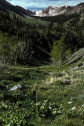
Mono County is a county located in the east central portion of the U.S. state of California. As of the 2020 census, the population was 13,195, making it the fourth-least populous county in California. The county seat is Bridgeport. The county is located east of the Sierra Nevada between Yosemite National Park and Nevada. The only incorporated town in the county is Mammoth Lakes, which is located at the foot of Mammoth Mountain. Other locations, such as June Lake, are also famous as skiing and fishing resorts. Located in the middle of the county is Mono Lake, a vital habitat for millions of migratory and nesting birds. The lake is located in a wild natural setting, with pinnacles of tufa arising out of the salty and alkaline lake. Also located in Mono County is Bodie, the official state gold rush ghost town, which is now a California State Historic Park.

<span class="mw-page-title-main">Churchill County, Nevada</span> County in Nevada, United States

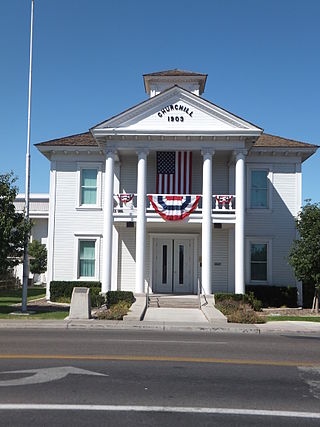
Churchill County is a county in the western U.S. state of Nevada. As of the 2020 census, the population was 25,516. Its county seat is Fallon. Named for Mexican–American War hero brevet Brigadier General Sylvester Churchill, the county was formed in 1861. Churchill County comprises the Fallon, NV Micropolitan Statistical Area. It is in northwestern Nevada. Churchill County is noteworthy in that it owns and operates the local telephone carrier, Churchill County Communications.

<span class="mw-page-title-main">Mohave County, Arizona</span> County in Arizona, United States

Mohave County is in the northwestern corner of the U.S. state of Arizona. As of the 2020 census, its population was 213,267. The county seat is Kingman, and the largest city is Lake Havasu City. It is the fifth largest county in the United States.

<span class="mw-page-title-main">Yavapai County, Arizona</span> County in Arizona, United States

Yavapai County is near the center of the U.S. state of Arizona. As of the 2020 census, its population was 236,209, making it the fourth-most populous county in Arizona. The county seat is Prescott.

<span class="mw-page-title-main">Washoe County, Nevada</span> County in Nevada, United States

Washoe County is a county in the U.S. state of Nevada. As of the 2020 census, the population was 486,492, making it Nevada's second-most populous county. Its county seat is Reno. Washoe County is included in the Reno, NV Metropolitan Statistical Area.

<span class="mw-page-title-main">Pershing County, Nevada</span> County in Nevada, United States

Pershing County is a county in the U.S. state of Nevada. As of the 2020 census, the population was 6,650. Its county seat is Lovelock. The county was named after army general John J. Pershing (1860–1948). It was formed from Humboldt County in 1919, and the last county to be established in Nevada. The Black Rock Desert, location for the annual Burning Man event, is partially in the county. The county is listed as Nevada Historical Marker 17. The marker is at the courthouse in Lovelock.

<span class="mw-page-title-main">Nye County, Nevada</span> County in Nevada, United States

Nye County is a county in the U.S. state of Nevada. As of the 2020 census, the population was 51,591. Its county seat is Tonopah. At 18,159 square miles (47,030 km2), Nye is Nevada's largest county by area and the third-largest county in the contiguous United States, behind Coconino County of Arizona and San Bernardino County of California.

<span class="mw-page-title-main">Lyon County, Nevada</span> County in Nevada, United States

Lyon County is a county in the U.S. state of Nevada. As of the 2020 census, the population was 59,235. Lyon County comprises the Fernley, NV Micropolitan Statistical Area which is part of the Reno-Carson City-Fernley, NV Combined Statistical Area.

<span class="mw-page-title-main">Lincoln County, Nevada</span> County in Nevada, United States

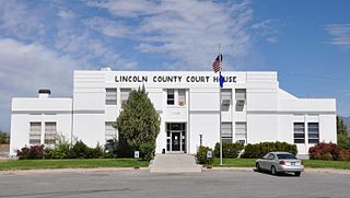
Lincoln County is a county in the U.S. state of Nevada. As of the 2020 census, the population was 4,499, making it the fourth-least populous county in Nevada. Its county seat is Pioche. Like many counties in Nevada, it is dry and sparsely populated, though notable for containing the Area 51 government Air Force base.

<span class="mw-page-title-main">Lander County, Nevada</span> County in Nevada, United States

Lander County is a county in the U.S. state of Nevada. As of the 2020 census, the population was 5,734. Its county seat is Battle Mountain.

<span class="mw-page-title-main">Humboldt County, Nevada</span> County in Nevada, United States

Humboldt County is a county in the U.S. state of Nevada. As of the 2020 Census, the population was 17,285. It is a largely rural county that is sparsely populated with the only major city being Winnemucca which has a population of 8,431. Humboldt County comprises the Winnemucca, NV Micropolitan Statistical Area and serves as an important crossroads in the national transportation network. Interstate 80 travels through the southeastern corner of the county, meeting US 95 in Winnemucca that serves as a primary freight corridor between Northern Nevada and Boise, Idaho and the Interstate 84 freight corridor that links much of the Pacific Northwest. The original transcontinental railway, constructed by the Central Pacific Railroad, reached Humboldt County on September 16, 1868. The Western Pacific Railroad would reach Humboldt County by November 1909, providing two mainline rail links to California and the Eastern United States. Both railroads have since been acquired by the Union Pacific Railroad, who continues to serve the region today.

<span class="mw-page-title-main">Eureka County, Nevada</span> County in Nevada, United States

Eureka County is a county in the U.S. state of Nevada. As of the 2020 census, the population was 1,855, making it the second-least populous county in Nevada. Its county seat is Eureka.

<span class="mw-page-title-main">Esmeralda County, Nevada</span> County in Nevada, United States

Esmeralda County is a county in the southwestern portion of the U.S. state of Nevada. As of the 2020 census, the population was 729, making it the least populous county in Nevada, and the 20th least populous county in the United States. Esmeralda County does not have any incorporated communities. Its county seat is the town of Goldfield.

<span class="mw-page-title-main">Elko County, Nevada</span> County in Nevada, United States

Elko County is a county in the northeastern corner of Nevada, United States. As of the 2020 census, the population was 53,702. Its county seat is Elko. The county was established on March 5, 1869, from Lander County.

<span class="mw-page-title-main">McGill, Nevada</span> CDP in Nevada, United States

McGill is a census-designated place (CDP) in White Pine County, Nevada, United States. The population was 1,148 at the 2010 census.

<span class="mw-page-title-main">Humboldt–Toiyabe National Forest</span> National forest in Nevada and California, United States

The Humboldt–Toiyabe National Forest (HTNF) is the principal U.S. National Forest in the U.S. state of Nevada, and has a smaller portion in Eastern California. With an area of 6,289,821 acres (25,454.00 km2), it is the largest U.S. National Forest outside of Alaska.

<span class="mw-page-title-main">Nevada Wilderness Areas</span>

In 1989 the U.S. Government enacted the Nevada Wilderness Bill, expanding the one existing Wilderness Area (Jarbidge) and creating thirteen new areas. The estimated total of 733,400 acres (296,800 ha) was over eleven times the area that had previously been under wilderness protection.

References

  1. 1 2 "State & County QuickFacts".
  2. "County Explorer". National Association of Counties. Retrieved June 7, 2011.
  3. "2010 Census Gazetteer Files". United States Census Bureau. August 22, 2012. Retrieved December 20, 2014.
  4. "Wheeler Peak, Nevada". Peakbagger.com.
  5. Fast facts about America's wilderness Archived June 14, 2019, at the Wayback Machine - Wilderness.net
  6. "Annual Estimates of the Resident Population for Counties: April 1, 2020 to July 1, 2023". United States Census Bureau. Retrieved March 26, 2024.
  7. "U.S. Decennial Census". United States Census Bureau. Retrieved December 20, 2014.
  8. "Historical Census Browser". University of Virginia Library. Retrieved December 20, 2014.
  9. "Population of Counties by Decennial Census: 1900 to 1990". United States Census Bureau. Retrieved December 20, 2014.
  10. "Census 2000 PHC-T-4. Ranking Tables for Counties: 1990 and 2000" (PDF). United States Census Bureau. Archived (PDF) from the original on March 27, 2010. Retrieved December 20, 2014.
  11. "U.S. Census website". United States Census Bureau . Retrieved January 31, 2008.
  12. 1 2 3 "DP-1 Profile of General Population and Housing Characteristics: 2010 Demographic Profile Data". United States Census Bureau. Archived from the original on February 13, 2020. Retrieved January 21, 2016.
  13. "Population, Housing Units, Area, and Density: 2010 - County". United States Census Bureau. Archived from the original on February 13, 2020. Retrieved January 21, 2016.
  14. "DP02 SELECTED SOCIAL CHARACTERISTICS IN THE UNITED STATES – 2006-2010 American Community Survey 5-Year Estimates". United States Census Bureau. Archived from the original on February 13, 2020. Retrieved January 21, 2016.
  15. "DP03 SELECTED ECONOMIC CHARACTERISTICS – 2006-2010 American Community Survey 5-Year Estimates". United States Census Bureau. Archived from the original on February 13, 2020. Retrieved January 21, 2016.
  16. "2020 CENSUS - SCHOOL DISTRICT REFERENCE MAP: White Pine County, NV" (PDF). U.S. Census Bureau. Archived (PDF) from the original on August 14, 2022. Retrieved August 14, 2022. - Text list
  17. Leip, David. "Dave Leip's Atlas of U.S. Presidential Elections". uselectionatlas.org. Retrieved April 12, 2018.
  18. The leading "other" candidate, Progressive Theodore Roosevelt, received 431 votes, while Socialist candidate Eugene Debs received 302 votes.

39°26′N114°54′W / 39.44°N 114.90°W / 39.44; -114.90