Mountain View Oil Field

Last updated
Mountain View Oil Field

MountainViewLoc.jpg

The Mountain View Oil Field in central California. Other oil fields are shown in dark gray.
Country United States
Region San Joaquin Basin
Location Kern County, California
Offshore/onshore onshore
Operators Atlantic, Pyramid, Sunray, The Termo, numerous others
Field history
Discovery 1933
Start of development 1933
Start of production 1933
Peak year 1936
Production
Current production of oil 437.5 barrels per day (~21,800 t/a)
Year of current production of oil 2008
Estimated oil in place 0.792 million barrels (~1.08×10^5 t)
Producing formations Walker (Oligocene), Santa Margarita (Miocene), Fruitvale (Miocene), Olcese (Miocene), Round Mountain (Miocene), Freeman-Jewett (Miocene), Chanac (Pliocene-Miocene), Kern River (Pleistocene), unnamed schist (Jurassic)

The Mountain View Oil Field is a large, mature, but still-productive oil field in Kern County, California, in the United States, in the extreme southern part of the San Joaquin Valley southeast of Bakersfield. It underlies the town of Arvin, as well as some smaller agricultural communities. The field is spread out across a large area, covering just under 8 square miles (21 km2), with wells and storage facilities widely dispersed throughout the area, scattered among working agricultural fields of broccoli and carrots as well as citrus orchards. Discovered in 1933, it has produced over 90 million barrels (14,000,000 m3) of oil in its lifetime, and although declining in production is one of the few inland California fields in which new oil is still being discovered. [1]

Kern County, California County in California, United States

Kern County is a county in the U.S. state of California. As of the 2010 census, the population was 839,631. Its county seat is Bakersfield.

San Joaquin Valley Valley in California

The San Joaquin Valley is the area of the Central Valley of the U.S. state of California that lies south of the Sacramento–San Joaquin River Delta and is drained by the San Joaquin River. It comprises seven counties of Northern and one of Southern California, including, in the north, all of San Joaquin and Kings counties, most of Stanislaus, Merced, and Fresno counties, and parts of Madera and Tulare counties, along with a majority of Kern County, in Southern California. Although a majority of the valley is rural, it does contain cities such as Fresno, Bakersfield, Stockton, Modesto, Turlock, Tulare, Porterville, Visalia, Merced, and Hanford.

Bakersfield, California City in California, United States of America

Bakersfield is a city in and the county seat of Kern County, California, United States. It covers about 151 sq mi (390 km2) near the southern end of the San Joaquin Valley and the Central Valley region. Bakersfield's population is around 380,000, making it the 9th-most populous city in California and the 52nd-most populous city in the nation. The Bakersfield–Delano Metropolitan Statistical Area, which includes all of Kern County, had a 2010 census population of 839,631, making it the 62nd-largest metropolitan area in the United States. The more built-up urban area that includes Bakersfield and areas immediately around the city, such as East Bakersfield, Oildale, and Rosedale, has a population of over 520,000. Bakersfield is a charter city.

Contents

As of the beginning of 2009, the field had numerous operators, unlike some of the larger, monolithic fields such as the Kern River field to the north, which is entirely owned by Chevron Corporation. Only independent oil companies operate on the Mountain View Field. Of the 175 active wells on the field in 2009, the largest operator was Atlantic Oil Company, with 49 producing wells; the second largest was Sunray Petroleum, with 22. Overall there were 23 separate operators, one of the most of any field in California. [2]

Kern River Oil Field

The Kern River Oil Field is a large oil field in Kern County in the San Joaquin Valley of California, north-northeast of Bakersfield in the lower Sierra foothills. Yielding a cumulative production of close to 2 billion barrels (320,000,000 m3) of oil by the end of 2006, it is the third largest oil field in California, after the Midway-Sunset Oil Field and the Wilmington Oil Field, and the fifth largest in the United States. Its estimated remaining reserves, as of the end of 2006, were around 476 million barrels (75,700,000 m3), the second largest in the state. It had 9,183 active wells, the second highest in the state. The principal operator on the field is Chevron Corporation

Chevron Corporation American multinational energy corporation

Chevron Corporation is an American multinational energy corporation. One of the successor companies of Standard Oil, it is headquartered in San Ramon, California, and active in more than 180 countries. Chevron is engaged in every aspect of the oil, natural gas, and geothermal energy industries, including hydrocarbon exploration and production; refining, marketing and transport; chemicals manufacturing and sales; and power generation. Chevron is one of the world's largest oil companies; as of 2017, it ranked nineteenth in the Fortune 500 list of the top US closely held and public corporations and sixteenth on the Fortune Global 500 list of the top 500 corporations worldwide. It was also one of the Seven Sisters that dominated the global petroleum industry from the mid-1940s to the 1970s.

Environmental setting

Gas-powered oil well within the Mountain View field, surrounded by row crops MountainViewWell.jpg
Gas-powered oil well within the Mountain View field, surrounded by row crops

Unlike the largest of the Kern County oil fields which occupy the arid hilly region ringing the Central Valley, the Mountain View field is one of several which entirely underlie the flat, richly agricultural valley bottomlands. It is long and relatively narrow, with the productive area of the field being almost 15 miles (24 km) long from its northwest to southeast extents, and from 1 to 3 miles (1.6 to 4.8 km) across. It consists of discontiguous areas, many of which are small, isolated, and some of which are abandoned. [3] Land use in the field is mainly agricultural, although the field also underlies the entire town of Arvin, as well as several small unincorporated communities. Oil wells are scattered throughout the region, never densely clustered; some are adjacent to homes in Arvin itself, and many are situated within clearings in the area's abundant orchards and fields of row crops. [4]

Two state highways pass through the field: California State Route 184, which runs south to north through the town of Lamont, passing through the extreme northwestern portion of the productive region; and Route 223 (Bear Mountain Boulevard), which goes west to east through the town of Arvin and then into the Tehachapi Mountains. Paved roads run along the section lines throughout at 1 mile (1.6 km) intervals.

California State Route 184 highway in California

State Route 184 is a state route in Kern County, California, locally known as “Weedpatch Highway.” It is mainly a 2-lane conventional highway, expanding to four lanes in Bakersfield, and Lamont. It connects the local agricultural land south of Bakersfield, and east of SR 99/I-5, to a major east/west freeway, SR 58. The freeway connects the San Joaquin Valley to all points southeast. It also connects to SR 178, a highway which runs from Bakersfield to the Kern Valley region, and SR 223, which connects I-5 to SR 58 on a route south of Bakersfield. SR 184 southern terminus is with Wheeler Ridge Rd, a county road. Although not a truck route, it is the only north/south road south of Bakersfield that directly connects to I-5, which runs east of SR 99. Its connection is with the Golden State Freeway section south of SR 99.

Lamont, California census-designated place in California, United States

Lamont is a census-designated place (CDP) in Kern County, California, United States. Lamont is located 9 miles (14 km) south-southeast of downtown Bakersfield, at an elevation of 404 feet (123 m). The population was 15,120 at the 2010 census, up from 13,296 at the 2000 census.

California State Route 223 highway in California

State Route 223 is a state route in Kern County, California, and is locally known as Bear Mountain Boulevard. It is a truck route, connecting the agricultural land south of Bakersfield and east of SR 99/I-5, and the city of Arvin, to three major transportation corridors without having to drive through Bakersfield. It connects to I-5 for goods traveling north and east of Sacramento. It connects to SR 99 for goods traveling to major San Joaquin Valley communities. It also connects to SR 58, for goods traveling to all points southeast, except for Los Angeles. For goods traveling south, trucks use SR 99 while cars can use Wheeler Ridge Road, which is a north-south county road that connects to I-5 south of SR 99.

Terrain in the vicinity of the oil field is almost table-flat, with elevations ranging from approximately 400 to 500 feet (120 to 150 m) above sea level throughout the productive region. The land rises with a slight gradient to the south and east, in the direction of the foothills of the Tehachapi Mountains. Climate is typical of the southern San Joaquin Valley, and is arid. Temperatures in the summer routinely exceed 100 °F (38 °C) on cloudless days. Rain falls mainly in the winter months, and averages 5 to 6 inches (130 to 150 mm) annually. Freezes occur occasionally during the winter, and the winter months are also subject to frequent dense tule fogs, limiting visibility to near zero. Drainage from the field is generally into the irrigation canal system, but because of the flat surface gradient most rainfall soaks directly into the ground. [5]

Tehachapi Mountains mountain range in Southern California

The Tehachapi Mountains are a mountain range in the Transverse Ranges system of California in the Western United States. The range extends for approximately 40 miles (64 km) in southern Kern County and northwestern Los Angeles County.

Tule fog

Tule fog is a thick ground fog that settles in the San Joaquin Valley and Sacramento Valley areas of California's Central Valley. Tule fog forms from late fall through early spring after the first significant rainfall. The official time frame for tule fog to form is from November 1 to March 31. This phenomenon is named after the tule grass wetlands (tulares) of the Central Valley. Tule fog is the leading cause of weather-related accidents in California.

Air quality in the vicinity of the oil field, and in Kern County in general, is among the worst in the United States. In 2009 Kern County had the worst particulate pollution in the U.S., [6] and was second-worst for ozone, after Los Angeles. [7]

Ozone chemical compound

Ozone, or trioxygen, is an inorganic molecule with the chemical formula O
3
. It is a pale blue gas with a distinctively pungent smell. It is an allotrope of oxygen that is much less stable than the diatomic allotrope O
2
, breaking down in the lower atmosphere to O
2
(dioxygen). Ozone is formed from dioxygen by the action of ultraviolet light (UV) and electrical discharges within the Earth's atmosphere. It is present in very low concentrations throughout the latter, with its highest concentration high in the ozone layer of the stratosphere, which absorbs most of the Sun's ultraviolet (UV) radiation.

Geology

Mountain View Oil Field Structure Map MountainViewOilFieldStructureMap.png
Mountain View Oil Field Structure Map

The Mountain View field is within the Southeast Stable Shelf, the southeastern extremity of the San Joaquin Basin Province, a region that contains numerous individual oil fields, including one of the largest in the United States – the Kern River Oil Field. [8] Unlike many of the fields in the surrounding foothills and uplands, the geology of the Mountain View field gives no surface expression at all, since the deep surface alluvium buries all trace of the underlying structures trapping petroleum. Discovery came by wildcat-well prospecting. Since fields to the north, including Kern River, Kern Front, and Edison, were already producing, it was a reasonable inference that their oil-bearing strata extended to the south, out of sight underneath the alluvium.

The overall structure of the field is a faulted homocline, with all the sedimentary units dipping in the same direction with little folding. The formations have a general strike towards the northwest, and dip to the southwest about 1,200 feet (370 m) for each mile. Updip migration of petroleum is blocked by impermeable units placed there by vertical fault offsets, with the faults being numerous, and the largest roughly following the strike of the beds. [3] [9]

Numerous oil-producing formations have been identified within the Mountain View field, ranging in age from the basement Jurassic schist, which itself contains some oil pools, all the way to Pliocene-Pleistocene at the top of the stratigraphic column. Viewed from above, the field is broken out into five discontiguous areas: the large Main Area, the Arvin and West Arvin areas near the town of that name, the abandoned Di Giorgio Area, and the Vaccaro Area in the extreme south-southeast. [3]

History, production, and operations

Numerous attempts were made to find the field, which was long suspected to exist. The first well in the area was drilled in 1924, and produced a small amount of oil, failing after four days. In the following years several more wells were drilled, including some by Shell Oil and Mohawk Petroleum Company, but all failed until Hogan Petroleum hit the rich Wharton pool in the Santa Margarita Formation at about 5,500 feet (1,700 m) below ground surface in May 1933. This well initially produced 3,200 barrels per day (510 m3/d) with a pressure of approximately 2,500 pounds per square inch (17,000 kPa)—a strong finding that brought other drillers to the area in short order. [10]

Subsequent wells expanding outwards from the discovery well delineated the limits of the main productive area by the late 1930s. In 1936, Mohawk Petroleum discovered the DiGiorgio Area by hitting oil in the Santa Margarita Formation. [11] The West Arvin area was discovered in 1937, with a well drilled into the Cattani pool of the Chanac Formation. [12] Also in 1937, General Petroleum Corp. of California discovered the Vaccaro Area. Each of these areas yielded subsequent discoveries in other deeper pools throughout the 1940s and 1950s. In 1986, a new discovery was made in the Kern River Formation in the Arvin Area, and smaller pools continue to be found in the widely dispersed oil field – for example, in 2006 Vaquero Energy, one of the field's current operators, found a new pool in the once-abandoned DiGiorgio area in the underlying schist basement rock. [13] [14]

As of the beginning of 2009, 175 wells remained active on the field, distributed between five discontiguous areas. Field-wide, the average production per well is 2.5 barrels (0.40 m3) of oil per day, with an 81 percent water cut (approximately four barrels of water come out of the reservoir for every barrel of oil). The Main Area remains the most productive, followed by the West Arvin and Arvin areas; many of the wells in these areas are slant-drilled to reach formations directly under the town. [15] [16]

Notes

  1. "2008 Report of the state oil & gas supervisor" (PDF). Department of Oil, Gas, and Geothermal Resources. California Department of Conservation ("DOGGR 2009"). 2009. Retrieved April 26, 2010. 239.
  2. DOGGR 2009, 110-168
  3. 1 2 3 DOGGR, 302
  4. John F. Matthews, Jr. Arvin and Vaccaro Areas of Mountain View Oil Field: California Division of Oil and Gas, Summary of Operations. 1961. Vol. 47 No. 1. 5-6
  5. "Ecoregion description". U.S. Forest Service. Archived from the original on 2005-03-11. Retrieved 2014-02-22.
  6. Report: Kern has the most dangerous pollution in U.S. KGET, Bakersfield, California. April 29, 2009.
  7. American Lung Association: Annual State of the Air Report
  8. Allegra Hosford Scheirer, ed. Petroleum Systems and Geologic Assessment of Oil and Gas in the San Joaquin Basin Province, California. Chapter 13, "Miocene Total Petroleum System—Southeast Stable Shelf Assessment Unit of the San Joaquin Basin Province", by Donald L. Gautier and Allegra Hosford Scheirer. USGS Professional Paper 1713, 2007. 1
  9. Miller, R.H. and Bloom, C.V. Mountain View Oil Field: California Division of Oil and Gas, Summary of Operations. 1937. Vol. 22 No. 4. 6, 14
  10. Miller and Bloom, 6-7
  11. DOGGR, 309
  12. DOGGR, 307
  13. DOGGR, 306
  14. DOGGR (2009), 239
  15. DOGGR (2009), 96
  16. Matthews, 6

Related Research Articles

Midway-Sunset Oil Field

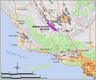
The Midway-Sunset Oil Field is a large oil field in Kern County, San Joaquin Valley, California in the United States. It is the largest known oilfield in California and the third largest in the United States.

South Belridge Oil Field

The South Belridge Oil Field is a large oil field in northwestern Kern County, San Joaquin Valley, California, about forty miles west of Bakersfield. Discovered in 1911, and having a cumulative production of over 1,500 million barrels (240,000,000 m3) of oil at the end of 2008, it is the fourth-largest oil field in California, after the Midway-Sunset Oil Field, Kern River Oil Field, and Wilmington Oil Field, and is the sixth-most productive field in the United States. Its estimated remaining reserves, as of the end of 2008, were around 494 million barrels (78,500,000 m3), the second-largest in the state, and it had 6,253 active wells. The principal operator on the field was Aera Energy LLC, a joint venture between Royal Dutch Shell and ExxonMobil. Additionally, the field included the only onshore wells in California owned and operated by ExxonMobil.

Elk Hills Oil Field

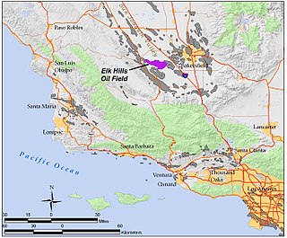
The Elk Hills Oil Field is a large oil field in northwestern Kern County, in the Elk Hills of the San Joaquin Valley, California in the United States, about 20 miles (32 km) west of Bakersfield. Discovered in 1911, and having a cumulative production of close to 1.3 billion barrels (210,000 dam3) of oil at the end of 2006, it is the fifth-largest oil field in California, and the seventh-most productive field in the United States. Its estimated remaining reserves, as of the end of 2006, were around 107 million barrels (17,000 dam3), and it had 2,387 active oil-producing wells. It is by an order of magnitude the largest natural gas-producing oil field in California, having produced over 2 trillion cubic feet (57 km3) of gas since its discovery, and retaining over 700 billion cubic feet (20,000,000 dam3) in reserve, making it even larger than the Rio Vista Gas Field, the largest non-associated natural gas field in the state.

Buena Vista Oil Field oil field in California, United States

The Buena Vista Oil Field, formerly the Naval Petroleum Reserve No. 2 (NPR-2) is a large oil field in Kern County, San Joaquin Valley, California in the United States. Discovered in 1909, and having a cumulative production of approximately 667 million barrels (106,000,000 m3), it is the tenth-largest oil field in California. It is also one of the closest to being exhausted, having a total reserve of only about one percent of its original oil, and having produced a mere 713,000 barrels (113,400 m3) in 2006.

Cymric Oil Field

The Cymric Oil Field is a large oil field in Kern County, California in the United States. While only the 14th-largest oil field in California in total size, in terms of total remaining reserves it ranks fifth, with the equivalent of over 119 million barrels (18,900,000 m3) still in the ground. Production at Cymric has been increasing faster than at any other California oil field.

Lost Hills Oil Field

The Lost Hills Oil Field is a large oil field in the Lost Hills Range, north of the town of Lost Hills in western Kern County, California, in the United States.

Mount Poso Oil Field

The Mount Poso Oil Field is a large oil and gas field in the lower foothills of the Sierra Nevada in Kern County, California, United States. Discovered in 1926, and relatively close to exhaustion with less than three percent of its original oil remaining, it is the 21st largest field in California by total ultimate oil recovery, having a cumulative production of close to 300 million barrels (48,000,000 m3). The current principal operator of the field is Plains Exploration & Production; 652 wells remained active at the end of 2006, while production had dwindled to 554,000 barrels (88,100 m3) during that year, from a peak of over 9 million barrels (1,400,000 m3) in 1981.

McKittrick Oil Field

The McKittrick Oil Field is a large oil and gas field in western Kern County, California. The town of McKittrick overlies the northeastern portion of the oil field. Recognized as an oil field in the 19th century, but known by Native Americans for thousands of years due to its tar seeps, the field is ranked 19th in California by total ultimate oil recovery, and has had a cumulative production of over 303 million barrels (48,200,000 m3) of oil. The principal operators of the field as of 2008 were Chevron Corp. and Aera Energy LLC, but many independent oil exploration and production companies were also active on the field. The California Department of Oil, Gas and Geothermal Resources (DOGGR) estimates approximately 20 million recoverable barrels of oil remain in the ground.

Kern Front Oil Field

The Kern Front Oil Field is a large oil and gas field in the lower Sierra Nevada foothills in Kern County, California. Discovered in 1912, and with a cumulative production of around 210 million barrels (33,000,000 m3) of oil, it ranks 29th in size in the state, and is believed to retain approximately ten percent of its original oil, according to the official estimates of the California Department of Oil, Gas, and Geothermal Resources (DOGGR). It is adjacent to the much larger Kern River Oil Field, which is to the southeast, and the Mount Poso Oil Field to the north.

South Cuyama Oil Field oil field

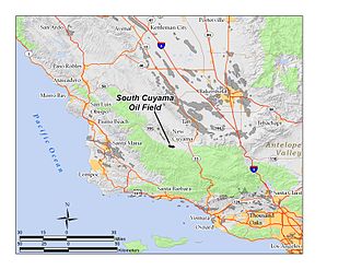
The South Cuyama Oil Field is a large oil and gas field in the Cuyama Valley and the adjacent northern foothills of the Sierra Madre Mountains in northeastern Santa Barbara County, California. Discovered in 1949, and with a cumulative production of around 225 million barrels (35,800,000 m3) of oil, it ranks 27th in size in the state, but is believed to retain only approximately two percent of its original oil, according to the official estimates of the California Department of Oil, Gas, and Geothermal Resources (DOGGR). Of the top forty onshore oil fields in California, it is the most recent to be discovered, but by the end of 2008 only 87 wells remained in production.

Fruitvale Oil Field

The Fruitvale Oil Field is a large oil and gas field in the southern San Joaquin Valley, California, within and just northwest of the city of Bakersfield, along and north of the Kern River. It is one of the few oil fields in the California Central Valley which is mostly surrounded by a heavily populated area. Discovered in 1928, and with a cumulative total recovery of more than 124 million barrels (19,700,000 m3) of oil at the end of 2006, it is 41st in size among California oil fields, and according to the California Department of Oil, Gas, and Geothermal Resources (DOGGR) its total reserve amounts to a little less than ten percent of its original oil.

Round Mountain Oil Field

The Round Mountain Oil Field is a large oil and gas field in the foothills of the Sierra Nevada, about 10 miles (16 km) northeast of Bakersfield, California, United States. It is east of the giant Kern River Oil Field, one of the largest in the United States, and also close to the Mount Poso Oil Field and Kern Front Oil Field. With a cumulative total recovery of more than 110 million barrels (17,000,000 m3) of oil, it is the 48th largest oil field in California, but remains relatively productive with still about ten percent of its reserves remaining in the ground, according to the California Department of Oil, Gas, and Geothermal Resources (DOGGR).

Vaccaro, California Former settlement in California, United States

Vaccaro is a former settlement in Kern County, California. It was located on the railroad 1.25 miles (2.0 km) south-southeast of Arvin, at an elevation of 423 feet. Vaccaro still appeared on maps as of 1933.

Long Beach Oil Field

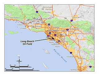
The Long Beach Oil Field is a large oil field underneath the cities of Long Beach and Signal Hill, California, in the United States. Discovered in 1921, the field was enormously productive in the 1920s, with hundreds of oil derricks covering Signal Hill and adjacent parts of Long Beach; largely due to the huge output of this field, the Los Angeles Basin produced one-fifth of the nation's oil supply during the early 1920s. In 1923 alone the field produced over 68 million barrels of oil, and in barrels produced by surface area, the field was the world's richest. The field is eighth-largest by cumulative production in California, and although now largely depleted, still officially retains around 5 million barrels of recoverable oil out of its original 950 million. 294 wells remained in operation as of the beginning of 2008, and in 2008 the field reported production of over 1.5 million barrels of oil. The field is currently run entirely by small independent oil companies, with the largest operator in 2009 being Signal Hill Petroleum, Inc.

Lompoc Oil Field

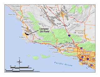
The Lompoc Oil Field is a large oil field in the Purisima Hills north of Lompoc, California, in Santa Barbara County. Discovered in 1903, two years after the discovery of the Orcutt Oil Field in the Solomon Hills, it is one of the oldest oil fields in northern Santa Barbara County, and one of the closest to exhaustion, reporting only 1.7 million barrels (270,000 m3) of recoverable oil remaining out of its original 50 million barrels (7,900,000 m3) as of the end of 2008. Its sole operator as of 2016 was Freeport McMoRan Oil and Gas, who acquired it with their 2013 purchase of Plains Exploration & Production. In 2009, the proposed decommissioning and habitat restoration of the 3,700-acre (15 km2) field was part of a controversial and so-far unsuccessful deal between Plains, several environmental groups, Santa Barbara County, and the State of California, to allow Plains to carry out new offshore oil drilling on the Tranquillon Ridge, in the Pacific Ocean about twenty miles (32 km) southwest of the Lompoc field.

South Mountain Oil Field

The South Mountain Oil Field is a large and productive oil field in Ventura County, California, in the United States, in and adjacent to the city of Santa Paula. Discovered in 1916, and having a cumulative production of over 158 million barrels (25,100,000 m3) of oil, it is the 37th largest oil field in California and the second largest in Ventura County. As of the beginning of 2009, it retains 316 active wells, and has an estimated 1.4 million barrels (220,000 m3) of oil remaining recoverable with current technology. Vintage Production, a subsidiary of Occidental Petroleum, was the largest operator as of 2009.

Semitropic Oil Field

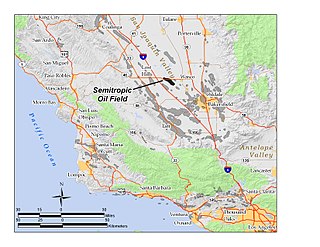
The Semitropic Oil Field is an oil and gas field in northwestern Kern County in California in the United States, within the San Joaquin Valley. Formerly known as the Semitropic Gas Field, it was discovered by the Standard Oil Company of California in 1935, and first understood to be primarily a natural gas reservoir; however, in 1956 a much deeper oil-bearing zone was discovered. The field contains the deepest oil well ever drilled in California, at 18,876 feet (5,753 m). At the end of 2008 the field still had 56 active oil wells, most of which were owned by Occidental Petroleum, and the field had an estimated 343,000 barrels of oil still recoverable with current technology.

Guijarral Hills Oil Field

The Guijarral Hills Oil Field is a formerly-productive oil and gas field near Coalinga on the western side of the Central Valley in central California in the United States. Discovered in 1948, and having produced 5.4 million barrels (860,000 m3) of oil during its peak year in 1950, it now has but one active oil well producing a little over a barrel of oil a day, and is very near to exhaustion, with only 343,000 recoverable barrels of oil remaining throughout its 2,515-acre (10.18 km2) extent according to the official California State Department of Conservation estimate. As of 2010, the only active operator was Longview Production Company.

Edison Oil Field

The Edison Oil Field is a large oil field in Kern County, California, in the United States, in the southeastern part of the San Joaquin Valley and adjacent foothills east-southeast of Bakersfield. The field has a total productive area of over 8,000 acres (32 km2), most of which is intermingled with agricultural land uses; oil pumps and storage tanks are surrounded with row crops and orchards in much of the field's extent. Discovered in 1928, and with a cumulative production of 149 million barrels (23,700,000 m3) of oil as of 2008, and having over 6 million barrels (950,000 m3) in reserve, it is ranked 38th among California's oil fields by total ultimate recovery. It is a mature field in decline, and is run entirely by small independent operators. As of 2008, there were 40 different oil companies active on the field, one of the most in the state for a single field. 914 wells remained active on the field, averaging only two barrels of oil per well per day from the dwindling reservoirs.

Cat Canyon Oil Field

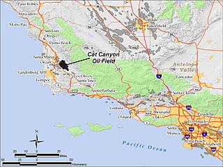
The Cat Canyon Oil Field is a large oil field in the Solomon Hills of central Santa Barbara County, California, about 10 miles southeast of Santa Maria. It is the largest oil field in Santa Barbara County, and as of 2010 is the 20th-largest in California by cumulative production.

References

Coordinates: 35°14′56″N118°52′13″W / 35.2490°N 118.8703°W / 35.2490; -118.8703