
Hemphill County is a county located in the U.S. state of Texas. As of the 2010 census, its population was 3,807. The county seat and only incorporated community in the county is Canadian. The county was created in 1876 and organized in 1887. It is named for John Hemphill, a judge and Confederate congressman. Hemphill County is one of six prohibition, or entirely dry, counties in the state of Texas.

Custer County is a county located in the U.S. state of Oklahoma. As of the 2010 census, the population was 27,469. Its county seat is Arapaho. The county was named in honor of General George Armstrong Custer.

Minco is a city in Grady County, Oklahoma, United States. The population was 1,632 at the 2010 census.

Canadian is a city in, and the county seat of, Hemphill County, Texas, United States. The population was 2,649 at the 2010 census, up from 2,233 in 2000. It is named for the nearby Canadian River, a tributary of the Arkansas River. Incorporated in 1908, Canadian is sometimes called "the oasis of the High Plains". Canadian is on the eastern side of the Texas Panhandle, close to the border with Oklahoma.

The Llano Estacado, sometimes translated into English as the Staked Plains, is a region in the Southwestern United States that encompasses parts of eastern New Mexico and northwestern Texas. One of the largest mesas or tablelands on the North American continent, the elevation rises from 3,000 feet (900 m) in the southeast to over 5,000 feet (1,500 m) in the northwest, sloping almost uniformly at about 10 feet per mile (1.9 m/km).
The Canadian River is the longest tributary of the Arkansas River in the United States. It is about 906 miles (1,458 km) long, starting in Colorado and traveling through New Mexico, the Texas Panhandle, and Oklahoma. The drainage area is about 47,700 square miles (124,000 km2).

The Santa Fe Trail was a 19th-century route through central North America that connected Franklin, Missouri with Santa Fe, New Mexico. Pioneered in 1821 by William Becknell, who departed from the Boonslick region along the Missouri River, the trail served as a vital commercial highway until 1880, when the railroad arrived in Santa Fe. Santa Fe was near the end of El Camino Real de Tierra Adentro, which carried trade from Mexico City.

The Oklahoma Panhandle is the extreme northwestern region of the U.S. state of Oklahoma, consisting of Cimarron County, Texas County and Beaver County, from west to east. As with other salients in the United States, its name comes from the similarity of its shape to the handle of a pan.

The Cimarron River extends 698 miles (1,123 km) across New Mexico, Oklahoma, Colorado, and Kansas. The headwaters flow from Johnson Mesa west of Folsom in northeastern New Mexico. Much of the river's length lies in Oklahoma, where it either borders or passes through eleven counties. There are no major cities along its route. The river enters the Oklahoma Panhandle near Kenton, Oklahoma, crosses the southeastern corner of Colorado into Kansas, reenters the Oklahoma Panhandle, reenters Kansas, and finally returns to Oklahoma where it joins the Arkansas River at Keystone Reservoir west of Tulsa, Oklahoma, its only impoundment. The Cimarron drains a basin that encompasses about 18,927 square miles (49,020 km2).

The Cherokee Trail was a historic overland trail through the present-day U.S. states of Oklahoma, Kansas, Colorado, and Wyoming that was used from the late 1840s up through the early 1890s. The route was established in 1849 by a wagon train headed to the gold fields in California. Among the members of the expedition were a group of Cherokee. When the train formed in Indian Territory, Lewis Evans of Evansville, Arkansas, was elected Captain. Thus, this expedition is sometimes written as the Evans/Cherokee Train. In 1850 four wagon trains turned west on the Laramie Plains, along Wyoming's southern border to Fort Bridger.

The Antelope Hills are a series of low hills in the bend of the Canadian River in northwest Roger Mills County, Oklahoma, near the border between western Oklahoma and the Texas panhandle. They were a major landmark for the Plains Indians and travelers on what is now the western plains of Oklahoma. The area was part of the Cheyenne-Arapaho reservation until the Land Run of 1892 opened it to non-Indian settlement. The hills are on the National Register of Historic Places.

Josiah Gregg was an American merchant, explorer, naturalist, and author of Commerce of the Prairies, about the American Southwest and parts of northern Mexico. He collected many previously undescribed plants on his merchant trips and during the Mexican–American War, for which he has often been credited in botanical nomenclature. After the war he went to California, where he reportedly died of a fall from his mount due to starvation near Clear Lake on 25 February 1850, following a cross-country expedition which fixed the location of Humboldt Bay.

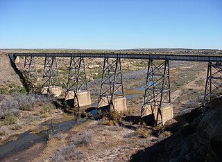
The Panhandle and Santa Fe Railway (P&SF) is a now-defunct railroad company that was a subsidiary of the Atchison, Topeka and Santa Fe Railway (AT&SF), operating primarily in the Texas Panhandle.

Tucumcari Mountain, once referred to as Tucumcari Peak or Mesa Tucumcari, is a mesa situated just outside Tucumcari, New Mexico.
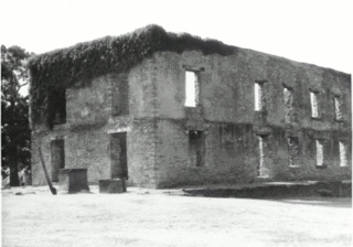
Fort Washita is the former United States military post and National Historic Landmark located in Durant, Oklahoma on SH 199. Established in 1842 by General Zachary Taylor to protect citizens of the Choctaw and Chickasaw Nations from the Plains Indians it was later abandoned by Federal forces at the beginning of the American Civil War. Confederate troops held the post until the end of the war when they burned the remaining structures. It was never reoccupied by the United States military. After years in private hands the Oklahoma Historical Society bought the fort grounds in 1962 and restored the site. Today, the Fort Washita Historic Site and Museum is a tourist attraction and hosts several events throughout the year, and it is jointly managed by the Chickasaw Nation and the Oklahoma Historical Society.

Preston, also known as Preston Bend, is an unincorporated community and census-designated place located on the Red River in Grayson County, Texas, United States. It grew in the 19th century at the intersection of several military and trade roads and was an important crossing on the Shawnee cattle trail. Preston lost prominence after the MK&T railroad bypassed the town to the east, leading to a decline in traveler and cattle drive traffic. Much of its former town site is submerged beneath the waters of Lake Texoma. Its population was 2,096 as of the 2010 census.
In the American Old West, overland trails were built by pioneers and immigrants throughout the 19th century and especially between 1829 and 1870 as an alternative to sea and railroad transport. These immigrants began to settle much of North America west of the Great Plains as part of the mass overland migrations of the mid-19th century. Settlers emigrating from the eastern United States were spurred by various motives, among them religious persecution and economic incentives, to move to destinations in the far west via routes including the Oregon Trail, California Trail, and Mormon Trail. After the end of the Mexican–American War in 1849, vast new American conquests again enticed mass immigration. Legislation like the Donation Land Claim Act and significant events like the California Gold Rush further lured people to travel overland to the west.

Southern Emigrant Trail, also known as the Gila Trail, the Kearny Trail, Southern Trail and the Butterfield Stage Trail, was a major land route for immigration into California from the eastern United States that followed the Santa Fe Trail to New Mexico during the California Gold Rush. Unlike the more northern routes, pioneer wagons could travel year round, mountain passes not being blocked by snows, however it had the disadvantage of summer heat and lack of water in the desert regions through which it passed in New Mexico Territory and the Colorado Desert of California. Subsequently, it was a route of travel and commerce between the eastern United States and California. Many herds of cattle and sheep were driven along this route and it was followed by the San Antonio-San Diego Mail Line in 1857-1858 and then the Butterfield Overland Mail from 1858 - 1861.

Black Beaver or Se-ket-tu-may-qua was a trapper and interpreter who worked for the American Fur Company. He served as a scout and guide as he was fluent in English, as well as several European and Native American languages. He is credited with establishing the California and Chisholm trails.
The history of Cleveland County, Oklahoma refers to the history of a county in the U.S. state of Oklahoma, and the land on which it developed prior to 1907 statehood. Prior to European colonization, the land represented the edge of the domain of the Plains Indians. France and Spain both colonized and explored the area before it became part of the United States via the Louisiana Purchase. It became part of the territory of the United States and tribal land and eventually part of the U.S. state of Oklahoma.


