Related Research Articles

Fort Towson was a frontier outpost for Frontier Army Quartermasters along the Permanent Indian Frontier located about two miles (3 km) northeast of the present community of Fort Towson, Oklahoma. Located on Gates Creek near the confluence of the Kiamichi River and the Red River in present-day Choctaw County, Oklahoma, it was named for General Nathaniel Towson.

The Sioux Wars were a series of conflicts between the United States and various subgroups of the Sioux people which occurred in the later half of the 19th century. The earliest conflict came in 1854 when a fight broke out at Fort Laramie in Wyoming, when Sioux warriors killed 31 American soldiers in the Grattan Massacre, and the final came in 1890 during the Ghost Dance War.

Fort Gibson is a historic military site located next to the present day city of Fort Gibson, in Muskogee County Oklahoma. It guarded the American frontier in Indian Territory from 1824 until 1888. When constructed, the fort lay farther west than any other military post in the United States; it formed part of the north–south chain of forts intended to maintain peace on the frontier of the American West and to protect the southwestern border of the Louisiana Purchase. The fort succeeded in its peacekeeping mission for more than 50 years, as no massacres or battles occurred there. The fort site is now managed by the Oklahoma Historical Society as the Fort Gibson Historical Site. It is a National Historic Landmark.

Fort Supply was a United States Army post established on November 18, 1868, in Indian Territory to protect the Southern Plains. It was located just east of present-day Fort Supply, Oklahoma, in what was then the Cherokee Outlet.
The Pacific Coast Theater of the American Civil War consists of major military operations in the United States on the Pacific Ocean and in the states and Territories west of the Continental Divide. The theater was encompassed by the Department of the Pacific that included the states of California, Oregon, and Nevada, the territories of Washington, Utah, and later Idaho.
The Department of the Missouri was a command echelon of the United States Army in the 19th century and a sub division of the Military Division of the Missouri that functioned through the Indian Wars.

Fort Griffin, now a Texas state historic site as Fort Griffin State Historic Site, was a US Cavalry fort established 31 July 1867 by four companies of the Sixth Cavalry, U.S. Army under the command of Lt. Col. S.D. Sturgis, in the northern part of West Texas, specifically northwestern Shackelford County, to give settlers protection from early Comanche and Kiowa raids. Originally called Camp Wilson after Henry Hamilton Wilson, a recently deceased lieutenant, it was later named for Charles Griffin, a former Civil War Union general who had commanded, as de facto military governor, the Department of Texas during the early years of Reconstruction.
Fort Richardson was a United States Army installation located in present-day Jacksboro, Texas. Named in honor of Union General Israel B. Richardson, who died in the Battle of Antietam during the American Civil War, it was active from 1867 to 1878. Today, the site, with a few surviving buildings, is called Fort Richardson State Park, Historic Site and Lost Creek Reservoir State Trailway. It was designated a National Historic Landmark in 1963 for its role in securing the state's northern frontier in the post-Civil War era.
The Morrisite War was a skirmish between a Latter Day Saint sect known as the "Morrisites" and the Utah territorial government.
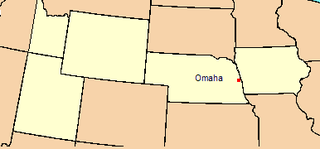
The Department of the Platte was a military administrative district established by the U.S. Army on March 5, 1866, with boundaries encompassing Iowa, Nebraska, Dakota Territory, Utah Territory and a small portion of Idaho. With headquarters in Omaha, the district commander oversaw the army's role initially along the Overland route to Salt Lake City, then later the construction route of the Union Pacific Railroad. The district also included the Montana road through eastern Wyoming. The district was discontinued when the Army's command was reorganized in 1898.
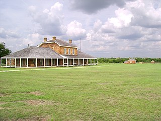
Fort Washita is the former United States military post and National Historic Landmark located in Durant, Oklahoma on SH 199. Established in 1842 by General Zachary Taylor to protect citizens of the Choctaw and Chickasaw Nations from the Plains Indians it was later abandoned by Federal forces at the beginning of the American Civil War. Confederate troops held the post until the end of the war when they burned the remaining structures. It was never reoccupied by the United States military. After years in private hands the Oklahoma Historical Society bought the fort grounds in 1962 and restored the site. Today the Fort Washita Historic Site and Museum is a tourist attraction and hosts several events throughout the year.

The history of Idaho in the American Civil War is atypical, as the territory was far from the battlefields.
The Utah Territory during the American Civil War was far from the main operational theaters of war, but still played a role in the disposition of the United States Army, drawing manpower away from the volunteer forces and providing its share of administrative headaches for the Lincoln Administration. Although no battles were fought in the territory, the withdrawal of Union forces at the beginning of the war allowed the Indian tribes to start raiding the trails passing through Utah. As a result, units from California and Utah were assigned to protect against these raids. Mineral deposits found in Utah by California soldiers encouraged the immigration of non-Mormon settlers into Utah.
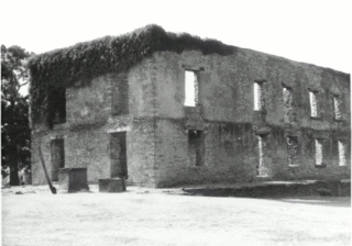
Fort Arbuckle was constructed by the US Army in 1850 to counter raids by Plains Indian tribes on immigrant trains heading west to California and on the settlements of Choctaw and Chickasaw nations in Indian Territory.

Fort Miller is former fort on the south bank of the San Joaquin River in what is now Madera County, California. It lay at an elevation of 561 feet. The site is now under Millerton Lake formed by the Friant Dam in 1944. It is registered as California Historical Landmark #584.
The District of Southern California was a nineteenth century district of Department of the Pacific, a command of the United States Army.
During the American Civil War in the early 1860s, the District of Utah was a subordinate district of the U.S. Army's Department of the Pacific. The district was composed of territorial areas that later became parts of the modern U.S. states of Idaho, Nevada, and Utah.
Fort Cobb was a United States Army post established in what is now Caddo County, Oklahoma in 1859 to protect relocated Native Americans from raids by the Comanche, Kiowa, and Cheyenne. The fort was abandoned by Maj. William H. Emory at the beginning of the Civil War and remained abandoned until it was reoccupied in 1868. After establishing Fort Sill the Army abandoned Fort Cobb. Today there is little left of the former military post.
The Department of California was one of two Army Departments created September 13, 1858, replacing the original Department of the Pacific and was composed of the territory of the United States lying west of the Rocky Mountains and south of Oregon and Washington territories, except the Rogue River and Umpqua Districts of southwestern Oregon Territory, which were assigned to the Department of California and excluding the Utah Territory east of the 117th meridian west and New Mexico Territory east of the 110th meridian west. Its creation was authorized by General Orders, No. 10, of the War Department, Adjutant-General's Office, September 13, 1858. Headquarters as before remained at San Francisco.
Fort Thorn or Fort Thorne, originally Cantonment Garland, was a settlement and military outpost located on the west bank of the Rio Grande, northwest of present-day Hatch, and west of Salem in Doña Ana County, New Mexico, United States. It was named for 1st Lt. Herman Thorn of the 2nd U.S. Infantry drowned in the Colorado River in 1849. He had previously been an aide to General John Garland, the new commander of the Ninth Military District, that encompassed New Mexico Territory in 1853.
References
- ↑ Frazer, Robert W. (1975). Forts of the West: Military Forts and Presidios and Posts Commonly Called Forts West of the Mississippi River to 1898. Norman, Oklahoma: University of Oklahoma Press. pp. 43–45. ISBN 9780806112503.