
Hunters Creek Village is a city in Harris County, Texas, United States, part of the Greater Houston metropolitan area. The population was 4,367 at the 2010 census. It is part of a collection of upscale residential communities in west Houston known as the Memorial Villages.

Piney Point Village is a city in Harris County, Texas, United States. The population was 3,125 at the 2010 census. Piney Point Village is the wealthiest place in Texas, as ranked by per capita income. It is part of a collection of upscale residential communities in west Houston known as the Memorial Villages.

This article documents the wide-ranging history of the city of Houston, the largest city in the state of Texas and the fourth-largest in the United States.

Downtown is the largest business district in the city of Houston and the largest in the state of Texas, located near the geographic center of the metropolitan area at the confluence of Interstate 10, Interstate 45, and Interstate 69. The 1.84-square-mile (4.8 km2) district, enclosed by the aforementioned highways, contains the original townsite of Houston at the confluence of Buffalo Bayou and White Oak Bayou, a point known as Allen's Landing. Downtown has been the city's preeminent commercial district since its founding in 1836.
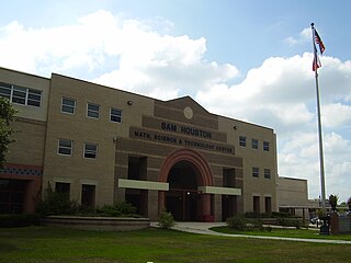
Sam Houston Math, Science, and Technology Center (SHMSTC) is a secondary school located at 9400 Irvington Boulevard in Houston, Texas, United States. Sam Houston Math, Science, and Technology Center handles grades nine through twelve and is part of the Houston Independent School District. Before 1955, it was located in Downtown Houston.
Harrisburg is a community that is now located within the city of Houston, Texas, United States.

The Memorial area of Houston, Texas is located west of Downtown, northwest of Uptown, and south of Spring Branch. The Memorial Super Neighborhood, as defined by the City of Houston, is bounded by Buffalo Bayou to the south, Barker Reservoir to the west, the Katy Freeway to the north, and the Memorial Villages, a contiguous group of independent municipalities, to the east.

Buffalo Bayou is a slow moving body of water which flows through Houston in Harris County, Texas. Formed 18,000 years ago, it has its source in the prairie surrounding Katy, Fort Bend County, and flows approximately 53 miles (85 km) east through the Houston Ship Channel into Galveston Bay and the Gulf of Mexico. In addition to drainage water impounded and released by the Addicks and Barker reservoirs, the bayou is fed by natural springs, surface runoff, and several significant tributary bayous, including White Oak Bayou, Greens Bayou, and Brays Bayou. Additionally, Buffalo Bayou is considered a tidal river downstream of a point 440 yards (400 m) west of the Shepherd Drive bridge in west-central Houston.
Meyerland is a community in southwest Houston, Texas, outside of the 610 Loop and inside Beltway 8. The neighborhood is named after the Meyer family, who bought and owned 6,000 acres (24 km²) of land in southwest Houston.

Memorial Park, a municipal park in Houston, Texas, is one of the largest urban parks in the United States. Opened 98 years ago in 1924, the park covers approximately 1,466 acres (5.9 km2) mostly inside the 610 Loop, across from the neighborhood of Memorial. Memorial Drive runs through the park, heading east to downtown Houston and west to the 610 Loop. A small portion of land west of the 610 Loop bordered by Woodway Drive and Buffalo Bayou is also part of the park. I-10/U.S. 90 borders the park to the north. The park was originally designed by landscape architects Hare & Hare of Kansas City, Missouri.

Rice Military is a neighborhood in Houston, Texas, United States. The Beer Can House is located in Rice Military.
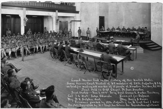
The Houston Riot of 1917 was a mutiny and riot by 156 soldiers from the all-black 24th Infantry Regiment of the United States Army, taking place on August 23, 1917, in Houston, Texas. The incident occurred within a climate of overt hostility from members of the all-white Houston Police Department (HPD) against members of the local black community and black soldiers stationed at Camp Logan. Following an incident where police officers arrested and assaulted some black soldiers, many of their comrades mutinied and marched to Houston, where they opened fire and killed eleven civilians and five policemen. Four soldiers were also killed and Sergeant Vida Henry, who led the mutineers, allegedly died by suicide. In accordance with policies of the time, the soldiers were tried at three courts-martial; nineteen were executed, and 41 were sentenced to life imprisonment.

Allen's Landing is the officially recognized birthplace of the city of Houston, Texas, United States, the largest city in Texas and the fourth largest in the United States. Located in Downtown Houston between the Main Street and Fannin Street viaducts, the landing encompasses the southern bank of Buffalo Bayou, the city's principal river, at its confluence with White Oak Bayou, a major tributary. Allen's Landing is located south of the University of Houston–Downtown Commerce Street Building.
Crestwood/Glen Cove is a community in Houston, Texas. It consists of the Crestwood and Glen Cove subdivisions. The Crestwood/Glen Cove Civic Club serves the Crestwood/Glen Cove community.

Olivewood Cemetery, in Houston, Texas, lies near a bend in White Oak Bayou, along the rail line to Chaney Junction, where the First and Sixth wards meet just northwest of downtown. The 6-acre (24,000 m2) cemetery is an historic resting place for many freed slaves and some of Houston's earliest black residents.
Briargrove Park (BGP) is a subdivision in western Houston, Texas, United States. It has about 1,480 houses. It is bounded by Beltway 8, the Buffalo Bayou, Gessner Road, and Westheimer Road.

Congregation Beth Israel of Houston, the oldest Jewish congregation in Texas, was founded in Houston in 1854. It operates the Shlenker School.
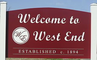
West End is a neighborhood in Houston, Texas, United States located along the Washington Avenue Corridor.

Emancipation Park and Emancipation Community Center are located at 3018 Emancipation Ave in the Third Ward area of Houston. It is the oldest park in Houston, and the oldest in Texas. In portions of the Jim Crow period it was the sole public park in the area available to African-Americans.

Buffalo Bayou Park is a 2.3 mile long municipal park located along the banks of the Buffalo Bayou near Downtown Houston, Texas.


